Flat Earth Proofs & Questions & Answers Proving The Earth Is Flat ?
22 videos
Updated 8 months ago
A Strangers Guide to the Flat Earth. A comprehensive beginners course that thoroughly explains the answers to the most frequently asked questions about flat earth.
Journey through the list from beginning to end while all the "loose ends" are tied up by the time it's over. Share with you friends, family and loved ones. The #earth is most definitely #flat and it is important for us to understand.
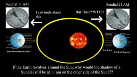
Flat Earth Proofs The largest collection of supposed "spinning ball Earth proofs" I can find from NASA is 10, all of which are debunked in the following video. So here is 20x the amount of proofs your government has ever given you that you are NOT living on a spinning ball planet. Please sit your friends and family down to watch this most important documentary and help share this on all your social media accounts so we can wake humanity up to this greatest deception and mother of all conspiracies!
What If Everything You Were Taught Was A Lie? All Info. shared for non-race and historical purposes to educate, elevate, entertain, enlighten, and empower through old and new film and document allowance is made for fair use for purposes such as criticism, comment, news reporting, scholarship, and research. Fair use is a use permitted by copyright statute that might otherwise be infringing. non-profit, educational or personal use tips the balance in favour of fair use.
-
Flat Earth Vs. Round Earth Vs. Black Knight Satellite Vs. Fermi Paradox The Great Debate
What If Everything You Were Taught Was A Lie?Is The Earth Flat Vs. Round Earth Vs. Black Knight Satellite Vs. Fermi Paradox? Here is my honest opinion on what I believe to be the actual shape of the Earth. This is only my opinion and what I believe. Flat-earthers believe one of the most curious conspiracy theories on the internet. Here's a look at what they believe and why. Of all the conspiracy theories that litter the Internet, the flat Earth conspiracy is quite possibly the most curious. After all, the ancient Greeks figured out the planet's shape (and even its circumference) in the third century B.C. But a fringe society founded in the 1950s, dedicated to insisting that the Earth is flat, has given rise to a modern ground of flat Earth adherents. These believers claim that the Earth is a flat disc, and that evidence that it is round — say, pictures taken from space — are an elaborate hoax involving multiple governments. Opinions differ on exactly how the flat Earth works, with believers concocting elaborate versions of physics and creative interpretations of the solar system to make their theories work. No one knows how many flat Earth believers are out there. According to Smithsonian Magazine, membership in the Flat Earth Society, founded in 1956, once reached 3,500 people. Today, the society claims more than 500 members on its roster. But some believers want nothing to do with the Flat Earth Society, according to a 2019 CNN article, with some attendees of the Flat Earth International Conference in Dallas that year telling the news agency that the organization is a government-sponsored front designed to make Flat Earthers look bad. (The Flat Earth Society responded to this by telling CNN, "We are not a government-controlled body. We're an organization of Flat Earth theorists that long predates most of the FEIC newcomers to the scene.") 81 Government & Affiliate Documents that admit Flat Earth It's A PDF Download. https://www.terre-plate.org/library/CIA%20NASA%20Documents/81%20Government%20_%20Affiliate%20Documents%20that%20admit%20Flat%20Earth-converted.pdf If a scientific conspiracy theory is funny, that doesn’t mean it’s a joke. As the Flat Earth Society/Flat Earth International Conference schism reveals, flat-earthers are not a monolithic group. The current president of the Flat Earth Society, Daniel Shenton, is a Londoner who now lives in Hong Kong. Robbie Davidson, who organizes the annual Flat Earth International Conferences, is a Canadian who espouses a Biblical worldview and opposes what he calls "scientism." A 2017 national poll by Public Policy Polling found that only 1% of Americans believed the Earth was flat, with an additional 6% saying they weren't sure. There was very little evidence of differences in this belief by political affiliation, with any differences between Trump voters, Clinton voters and third-party voters falling within the poll's margin of error of 3.2%. A 2018 article in the Colorado Sun on a flat Earth convention in Denver found that many attendees believed a whole suite of conspiracy theories, such as that all politicians are actors and that powerful shadowy forces control the world. Flat-earthers occasionally get a boost from celebrity believers. For instance, on Jan. 25, 2016, rapper-singer Bobby Ray Simmons Jr. (known as B.o.B) released a track called "Flatline" in which he disses astrophysicist Neil deGrasse Tyson, after the two had a Twitter battle over the spherical-ness of the planet. B.o.B is convinced Earth is flat. A day earlier, the rapper tweeted: "No matter how high in elevation you are... the horizon is always eye level ... sorry cadets... I didn't wanna believe it either." In 2018, NBA player Kyrie Irving had to apologize after causing a media controversy by speculating that the Earth was flat on a 2017 podcast. The leading flat-earther theory holds that Earth is a disc with the Arctic Circle in the center and Antarctica, a 150-foot-tall (45 meters) wall of ice, around the rim. NASA employees, they say, guard this ice wall to prevent people from climbing over and falling off the disc. (In keeping with their skepticism of NASA, known flat-earther conspiracy theorist Nathan Thompson approached a man he said was a NASA employee in a Starbucks in mid-May 2017. In a YouTube video of the exchange, Thompson, founder of the Official Flat Earth and Globe Discussion page, shouted that he had proof the Earth is flat — apparently saying an astronaut drowning was that proof — and that NASA is "lying.") Furthermore, Earth's gravity is an illusion, they say. Objects do not accelerate downward; instead, the disc of Earth accelerates upward at 32 feet per second squared (9.8 meters per second squared), driven up by a mysterious force called dark energy. Currently, there is disagreement among flat-earthers about whether or not Einstein's theory of relativity permits Earth to accelerate upward indefinitely without the planet eventually surpassing the speed of light. (Einstein's laws apparently still hold in this alternate version of reality.) As for what lies underneath the disc of Earth, this is unknown, but most flat-earthers believe it is composed of "rocks." It's worth noting that all of the above is completely contentious even within the flat Earth community. "None of us believe that we're a flying pancake in space," Davidson told CNN in the 2019 article. At the Flat Earth International Conferences, it's more common to believe that space simply does not exist at all and the disc of the Earth sits still, he said. One speaker at the 2018 FEIC even argued that Earth is neither a sphere nor a disc, but instead is shaped like a diamond, according to The Guardian. Flat Earth opinions about the moon vary. Some think that while Earth is flat, the moon and sun are spheres, Live Science's sister site Space.com reported. In this vision of the solar system, Earth's day and night cycle is explained by positing that the sun and moon are spheres measuring 32 miles (51 kilometers) that move in circles 3,000 miles (4,828 km) above the plane of the Earth. (Stars, they say, move in a plane 3,100 miles up.) Like spotlights, these celestial spheres illuminate different portions of the planet over a 24-hour cycle. Flat-earthers believe there must also be an invisible "antimoon" that obscures the moon during lunar eclipses. On YouTube, there are videos pointing to shadows in pictures of the moon and arguing that the moon is transparent, and thus just a light. One speaker at the 2018 conference attended by a Guardian reporter made a case for the moon as a projection. If flat-earthers seem hard to dissuade based on standard scientific evidence, there's a reason for that: flat Earth theorizing follows from a mode of thought called the "Zetetic Method." The Zetetic Method is an alternative to the scientific method, developed by a 19th-century flat-earther, in which sensory observations reign supreme. "Broadly, the method places a lot of emphasis on reconciling empiricism and rationalism, and making logical deductions based on empirical data," Flat Earth Society vice president Michael Wilmore, an Irishman, told Live Science in 2017. In Zetetic astronomy, the perception that Earth is flat leads to the deduction that it must actually be flat; the antimoon, NASA conspiracy and all the rest are just rationalizations for how that might work in practice. Those details make the flat-earthers' theory so elaborately absurd it sounds like a joke, but many of its supporters genuinely consider it a more plausible model of astronomy than the one found in textbooks. In short, they aren't kidding. "The question of belief and sincerity is one that comes up a lot," Wilmore said. "If I had to guess, I would probably say that at least some of our members see the Flat Earth Society and Flat Earth Theory as a kind of epistemological exercise, whether as a critique of the scientific method or as a kind of 'solipsism for beginners.' There are also probably some who thought the certificate would be kind of funny to have on their wall. That being said, I know many members personally, and I am fully convinced of their belief." Wilmore counts himself among the true believers. "My own convictions are a result of philosophical introspection and a considerable body of data that I have personally observed, and which I am still compiling," he said. Wilmore and the society's president Shenton both think the evidence for global warming is strong, despite much of this evidence coming from satellite data gathered by NASA, the kingpin of the "round Earth conspiracy." They also accept evolution and most other mainstream tenets of science. This is in contrast to Davidson, who disputes other scientific theories and findings, such as evolution, that contradict a strict interpretation of the Bible. Despite the claims from flat-earthers, there are plenty of ways to know that the world is round. One quick option is to check out NASA's image library, which is chock-full of nice, curvy pictures of the globe taken from the International Space Station. If NASA is hoaxing everyone, they're committed to the bit. Don't trust NASA? The Russians also snap pictures of the round Earth, Space.com reported. So does Japan's space agency. And China's. For the flat-earther convinced that all these countries put aside their political tensions in order to maintain the fiction of a spherical Earth, there are also ways to check on the planet's shape with one's own eyes. One of the simplest is to go to a harbor and watch the ships depart. As a ship disappears over the horizon, the bottom of the ship will go first, followed gradually by the mast. You can also take a page out of the ancient Greeks' book. Ancient Hellenistic philosophers figured out that the world had to be a globe based on a few observations. One was that the stars aren't the same in the Northern and Southern Hemispheres: From opposite halves of the Earth, you're clearly looking out at different quadrants of space. Another was that Earth's shadow on the moon's surface during lunar eclipses is curved. The Greeks even figured out how to calculate an approximate circumference of the Earth with no fancier tools than a stick and the light of the sun. By measuring the angle of a shadow cast by the sun at the same time and day in two cities a known distance apart, the philosopher Eratosthenes was able to calculate that the planet's circumference was between 24,000 and about 29,000 miles (38,600 and 46,670 kilometers). (It's actually 24,900 miles.) The very fact that the angle of the sun differs on different parts of the planet indicates that we're all sitting on a globe. As inconceivable as their belief system seems, it doesn't really surprise experts. She said all conspiracy theories share a basic thrust: They present an alternative theory about an important issue or event, and construct an (often) vague explanation for why someone is covering up that "true" version of events. "One of the major points of appeal is that they explain a big event but often without going into details," she said. "A lot of the power lies in the fact that they are vague." The self-assured way in which conspiracy theorists stick to their story imbues that story with special appeal. After all, flat-earthers are more adamant that the Earth is flat than most people are that the Earth is round (probably because the rest of us feel we have nothing to prove). "If you're faced with a minority viewpoint that is put forth in an intelligent, seemingly well-informed way, and when the proponents don't deviate from these strong opinions they have, they can be very influential. We call that minority influence. Five Impossible Facts That Would Have To Be True If The Earth Were Flat. From any one location on the surface of the Earth, it's impossible to tell what our planet's shape is. Having a single vantage point, even with a clear horizon, allows you to see a handful of miles (or kilometers) in any direction, but that can only allow you to place constraints. The Earth could be flat, or spherical, or in hydrostatic equilibrium, or egg-shaped, or irregular, and you wouldn't know. All that you can know, from a single location on our surface, is that the Earth is indistinguishable from flat beyond a certain degree. If the Earth is round, it must be quite large: more than a few hundred miles (or kilometers) in diameter. Of course, it actually is quite round: a near-perfect sphere, to better than 99% precision. If you leave Earth's surface, it's impossible not to see the true shape of the Earth, as it's been unavoidable since we first traveled high enough to observe our planet's curvature. From high altitudes, or even from space, the true shape of the Earth can easily be seen. Its dimensions can be measured; its radius of curvature in all directions can be calculated; the imperfections and departures from sphericity are directly observable by our instruments. If you travel far enough away from Earth, you can observe an entire hemisphere at once, even watching the planet rotate on its axis in real time. At right around 12,700 kilometers (7,900 miles) in diameter, our world is undoubtedly a sphere. But what if you had never been to space, or high enough up to see the Earth's curvature yourself? What if you had never circumnavigated the globe, done the Eratosthenes experiment, or heard about the Shaquille O'Neal experiment that anyone can perform? Believe it or not, there are still a number of simple observations you can make that wouldn't occur if the Earth were flat. Here are the top five simplest ones. 1.) Lunar Eclipses don't occur only at midnight. Take a look at the shape of the Earth's shadow during a lunar eclipse, particularly during a partial phase. Do you notice how the Earth's shadow always appears to be a piece of a near-perfect circle? If the Earth were a flat disk, that means there's only one possible orientation that the Sun-Earth-Moon alignment can take place in to create a circular (rather than elliptical) shadow: with the Earth's "disk" perpendicular to the Sun-Moon plane. This means the Sun would need to be at the "midnight" position relative to the night side of Earth, and yet lunar eclipses occur at all different times depending on where you are on Earth. The flat Earth can't explain that. 2.) Different locations on Earth experience seasons at different times. Ever notice how the summer in the United States corresponds to winter in Australia? Or how winter in Italy lines up with summer in Argentina? This is because the Sun's rays, which are almost perfectly parallel, strike Earth at different angles during different parts of the year. If the Earth were flat, the Sun's rays would always come in at the same angle, meaning that the USA, Australia, Italy, and Argentina would all experience the seasons the same exact way. The flat Earth idea can't explain this. 3.) Different stars are visible from different latitudes. Look up at the night sky from a very high (northern) latitude location, and you'll see the Big and Little Dippers, the bright orange giant Arcturus, and the Pleiades, among other sights. Yet if you head to the south pole, none of these celestial sights are visible, but you can see Alpha Centauri, the Magellanic Clouds, and the Southern Cross, all of which are never visible to most northern hemisphere skywatchers. If the Earth were flat, everyone on the night side of the Earth would see the same sky; this is another observation that the flat Earth can't account for. 4.) You cannot see Kawaikini from the peak of Mauna Kea. Mauna Kea, the highest peak in Hawaii (the summit of the Big Island), offers incredible views. With nothing but the ocean around it, and a few other nearby islands, you should be able to see extremely far away. The island of Kauai has the seventh highest point in the Hawaiian islands: the peak known as Kawaikini. If you were to draw a straight line from Mauna Kea (elevation: 13,796 ft.) to Kawaikini (elevation: 5226 ft.) it would span a distance of 303 miles. However, you cannot see one from the other, which you would absolutely be able to do if the Earth were flat. With a curved Earth of its measured radius, the line-of-sight limit for those two elevations caps out at 233 miles. Only with a curved Earth is one invisible from the other, and this is true for any two mountain peaks with clear line-of-sights from one to the other. 5.) Sunsets and sunrises happen at different times depending on your longitude. If the Earth were flat, then someone in New York and someone in Los Angeles would see the sun rise and set at exactly the same time as one another. But in practice, the difference is approximately three hours. Not only that, but at every point in between, the Sun rises/sets at a different time, something that could not happen if the Earth were flat. The fact that it can be evening in New York and late afternoon in Los Angeles, or morning in New York while it's still before dawn in Los Angeles, is something that a flat Earth can't account for. If the Earth were flat, these five phenomena would be very different, and yet they are so simple to verify that any flat Earth believer cannot possibly doubt their veracity. Whether it changes anyone's mind is up for debate, but without resorting to space, circumnavigation, or any advanced scientific experiments, you can experience a whole handful of phenomena that a flat Earth can't account for. With a flat Earth, we'd only get lunar eclipses at midnight, everywhere would have the same seasons, every location would see the same stars, all high mountain peaks would be visible from one another, and every place on your "side" of the Earth would see sunrise and sunset at the same time. Since these are false, so is the flat Earth. If this helps even one person challenge their belief that the Earth is flat, it's a remarkable win for knowledge. But don't bet on it. Like the old saying goes, you can't reason someone out of a position they didn't reason themselves into. Does the Bible prove that the Earth is round and not flat? Despite the many images of the Earth we have from space, theories about the Earth being flat continue to arise. By searching the Scriptures, you will not find proof that the Earth is round. Language in Scripture reflects the ancient Near East writers’ observations of the sun moving through its circuit in the sky (Ps. 19:6), of the sun rising and falling (Ps. 50:1; 113:3; Isa. 59:19; Mal. 1:11), and of the horizon being circular (Job 26:10). The role of Scripture is to reveal spiritual matters, not to argue for scientific fact. For this reason, Scripture does not mention many scientific discoveries. The Bible is for making us wise toward salvation to carry out the work of the gospel (2 Tim. 3:14–17). Believers must be people of truth (Prov. 12:19; Eph. 4:25); lying is a characteristic of those outside of Christ (1 Tim. 1:10; Titus 1:12; Rev. 21:8). As people of truth, in humility, we should tell people who debate over the spherical shape of the Earth that such an argument is unnecessary, for all related data points to the truth of a spherical Earth. When we encounter those who wish to argue, we should walk away and not argue with foolishness (Prov. 26:4–5). We can leave such persons to ponder the swirling of the water in their sinks and bathtubs—swirling that reverses direction when we cross the equator. https://samuel-lereah.com/articles/Physics/flat-vs-round-earth According to some UFO conspiracists, the Black Knight is an artificial satellite of extraterrestrial origin that has orbited Earth for approximately 13,000 years. However, this story is most likely a conflation of several disconnected stories about various objects and their interpretations, all of which have been well documented independently and none using the term Black Knight upon their first publication. The Black Knight's narrative is essential a recall of man previous stories, each with its own unique interpretation, all of which have been thoroughly recorded and studied by leading authorities. A photo taken during the STS-88 mission claimed by some to show the Black Knight satellite is catalogued by NASA as a photo of space debris, and space journalist James Oberg considers it as probable debris of a thermal blanket confirmed as lost during the mission. The claim that the black object is a satellite of extraterrestrial origin near Earth is false, according to NASA. The 'Black Knight' satellite: A hodgepodge of alien conspiracy theories It's a convoluted story that invokes Nikola Tesla, a spacewalker's fumble and more. Sometimes the introduction of a news report will stop you in your tracks, forcing you to reread in fear you didn't quite grasp its point the first time. That was certainly the case when Mail Online published a story on Mar. 21, 2017: "An alien satellite set up more than 12,000 years ago to spy on humans has been shot down by elite soldiers from the illuminati, UFO hunters claim." And with that, the conspiracy surrounding the so-called "Black Knight" satellite appeared to be very much alive. It's been more than 120 years, conspiracists believe, since the existence of the Black Knight was first recorded. Those who subscribe to the theory invoke an extraterrestrial spacecraft in near-polar orbit of Earth, although they draw upon pieces of evidence so disparate that it's not entirely clear why people link them. What it all amounts to is a strange brew that has spurred some folks to shout about cover-ups by NASA and other government entities. It's a legend that refuses to go away. A lot of the earliest discoveries that have been linked to the Black Knight satellite theory relate to radio signals. But a series of images from 1998 really threw the celestial cat among the pigeons. They were taken during STS-88, the first space shuttle mission to the International Space Station (ISS). There, for all to see, were images released by NASA that showed a black object hovering above our planet in low Earth orbit. And it wasn't long after the images were thrust in front of a hopeful public before people were performing some conspiratorial sums and sharing them with the wider world. By way of explanation, STS-88 astronaut Jerry Ross pointed out that the ISS was in the midst of being constructed when the images were taken. The U.S. team, he said, was on its way to attach the American module to the one created by the Russians and, as part of that work, they had taken four trunnion pin thermal covers with them. The task was to wrap these around four bare trunnion pins, these being rods that attached the module to the space shuttle Endeavour while it was being transported. This would act to prevent heat loss from the exposed metal. Unfortunately, during one of the spacewalks associated with this work, things went a little bit wrong: One of the covers came loose from its tether, causing it to float away along with some other items. "Jerry, one of the thermal covers got away from you," STS-88 commander Robert Cabana (who now serves as associate administrator of NASA) told Ross during the spacewalk, and it soon became apparent that the cover was lost for good. Subsequently captured on camera, this runaway black object was given the catalog number 025570 by NASA. A few days later, the item fell from orbit and burned up. Much of this information been placed on the record. Former NASA engineer James Oberg, who personally knows Ross and the person who took the photos, cosmonaut Sergei Krikalev, has demonstrated that these supposed images of the Black Knight actually depict a very mundane object. "Before leaving NASA, I led the trajectory design team that produced the mission profile," Oberg told All About Space. "Every step of the way, there is consistency with what I learned as a lifelong spaceflight operations specialist: why the blankets were needed, why one of them came loose, why it floated off the way it did," he added. "The difference is, for the general public all these features are unearthly to folks who are only familiar with Earthside principles of heating, working, motion and dozens of other never-before-encountered-in-history aspects of outer space." Given Oberg's thorough debunking, you'd think the matter would have been put to bed long ago. But no. Since the images were shared far and wide, conspiracy theories have lingered. "They are probably some of the weirdest-looking 70-mm photos to ever come out of the space shuttle program," Oberg said. “And apparently a NASA website update made the original links inoperative, sparking concerns over a cover-up. All normal journalistic practices — determining the timeline, asking witnesses, searching for the wider context — were skipped." Conspiracists absorbed the STS-88 images into a growing body of "evidence," claiming they were proof that the Black Knight alien satellite really is out there. Reaching that conclusion, however, has required greats leaps of faith, and has also needed past observations to be forced into the overall story. Firm believers have had no problems going all the way back to 1899 in pursuit of such "truth," but, just like the photographic records, each piece of supposed evidence brought to the table so far has been explained just fine without falling back on the Black Knight myth. So what happened in 1899? Nikola Tesla began to record some very odd signals, seemingly from outer space. While in his barn-like laboratory in Colorado Springs that year, the genius Serbian-American inventor and electrical engineer noted some unusual radio signals and speculated they had come from an intelligent alien civilization. That's perhaps the least likely explanation, of course. Over the years, some people have speculated that Tesla may have detected emissions from a pulsar, a superdense, fast-spinning stellar corpse. But that's probably off the mark as well, scientists say. "The very first source of non-terrestrial radio waves was discovered in the 1930s, and that was from the center of our galaxy, which is the most powerful radio source in the sky at many frequencies," said Varoujan Gorjian, a scientist at NASA's Jet Propulsion Laboratory in Southern California. "It wasn’t until the 1960s that the technology evolved to detect the first pulsars. If what Tesla detected was a real signal and not an artifact of his instrument, it most likely came from Earth." People continued to use Tesla's findings to bolster claims for the Black Knight. They also took on board the work of a Norwegian engineer called Jørgen Hals, who in the 1920s found that radio signals he transmitted were being echoed back to him a few seconds later. We now know these as long delayed echoes, and Hals was the first person to observe them. The fact that we don't have a confirmed explanation of their cause, however, has been seized upon: In 1973, Duncan Lunan wrote an article in Spaceflight magazine suggesting that people studying long delayed echoes had overlooked the possibility they were sent by an alien space probe. Lunan still has faith in an extraterrestrial explanation for the recordings. "The changes in the long distance echo patterns in apparent response to changes in the outgoing signals from Earth really do look like the responses of a Bracewell probe, and there is still no satisfactory natural explanation for the phenomenon," he said, referring to a hypothesized autonomous spacecraft designed to communicate with other civilizations. If the long distance echoes were deliberately produced by a probe, however, there's a problem in that they stopped in 1975. "If a probe was monitoring Earth, rather than trying to attract attention, perhaps it belatedly discovered from the 1973 to 1974 publicity that it had given away its presence in the 1920s and pulled out in 1975," Lunan said. "That's the only explanation I can see for its apparent departure." And yet, for all of that, Lunan said his research has nothing to do with the "Black Knight nonsense." If there is a link between his theory and the Black Knight, it is not one that is being made by him. The Black Knight conspiracy theory may be with us for a while yet, for there is growing public interest in unidentified flying objects (UFOs) — or, as the US military has recently rebranded them, unidentified aerial phenomena (UAP). This interest really began to surge in December 2017, when The New York Times published three videos captured by cameras aboard US Navy jets. The footage showed objects that appeared to maneuver in ways beyond the capabilities of known technology. That New York Times story also discussed the Advanced Aerospace Threat Identification Program (AATIP), a previously secret US military project looking into UFOs. Politico and The Washington Post published their own pieces about AATIP around that same time, adding to the UFO momentum. AATIP officially lasted just from 2007 to 2012. But in 2020, the military announced a successor program called the Unidentified Aerial Phenomena Task Force, whose mission is "to detect, analyze and catalog UAPs that could potentially pose a threat to US national security." This is a very practical concern for military officials. For example, what if some of the mysterious objects are alarmingly advanced reconnaissance craft developed by adversary nations? So there is some real intrigue and mystery surrounding UFOs, some of which are difficult to explain. But that mystery does not extend to the Black Knight, a wayward thermal blanket that burned up in Earth's atmosphere more than two decades ago. Fermi Paradox: Where are the aliens? The Fermi Paradox seeks to answer the question of where the aliens are. Given that our solar system is quite young compared to the rest of the universe — roughly 4.5 billion years old, compared to 13.8 billion — and that interstellar travel might be fairly easy to achieve given enough time, Earth should have been visited by aliens already, the idea goes. The paradox takes its name from Nobel Prize-winning physicist Enrico Fermi, who supposedly made the above points during a casual lunchtime conversation in 1950. And the implications have had astrobiologists and other scientists scratching their heads in the decades since. "Fermi grasped that any civilization with a modest amount of rocket technology and an immodest amount of imperial incentive could rapidly colonize the entire galaxy," representatives of the Search For Extraterrestrial Intelligence (SETI) Institute in Mountain View, California, wrote in a Fermi Paradox explainer. "Within a few tens of millions of years, every star system could be brought under the wing of empire. Tens of millions of years may sound like a long project, but in fact it’s quite short compared to the age of the galaxy, which is roughly a thousand times more." Fermi died in 1954, so exploration and explication of the idea fell to other people, such as Michael Hart, who wrote an article titled "An explanation for the absence of extraterrestrials on Earth" in the Royal Astronomical Society (RAS) Quarterly Journal in 1975. (Some say this is the first such paper to explore the Fermi Paradox, although this claim is a bit hard to prove.) "We observe that no intelligent beings from outer space are now present on Earth," Hart wrote in the paper's abstract. "It is suggested that this fact can best be explained by the hypothesis that there are no other advanced civilizations in our galaxy." He noted, however, that more research in biochemistry, planetary formation and atmospheres was needed to better narrow down the answer. Hart argued that intelligent aliens could already have visited Earth at some point in our planet's history unless they started their journey less than two million years ago. He thought the apparent lack of such visits is most likely due to the lack of intelligent aliens. But he outlined four other potential explanations as well: Aliens never came here because of a physical difficulty "that makes space travel infeasible," which could be related to astronomy, biology or engineering. Aliens simply chose never to visit us. Advanced civilizations beyond Earth arose too recently for aliens to reach us. Aliens have visited Earth in the past, but we have not observed them. Frank Tipler, a professor of physics at Tulane University, followed up on Hart's argument in 1980 with a paper titled "Extraterrestrial intelligent beings do not exist," also published in the RAS Quarterly Journal. The bulk of his paper dealt with how to get resources for interstellar travel, which he suggested could be achieved by having some kind of self-replicating artificial intelligence move from star system to star system, creating copies of itself as it traveled. Since evidence of such advanced machinery has never been found on Earth, Tipler argued that we are likely the only intelligence out there. He also wrote in the 1980 paper that those who believe in extraterrestrial intelligence are similar to UFO (unidentified flying object) enthusiasts because both camps believe "we are going to be saved from ourselves by some miraculous interstellar intervention." Today, the topic of extraterrestrial intelligence is a popular one, with multiple papers appearing every year from different research groups. And the idea that advanced civilizations may exist beyond Earth has been buoyed by the ongoing exoplanet revolution. The universe is incredibly vast and old. Data gathered by a variety of telescopes show that the observable universe is about 92 billion light-years wide (and growing faster and faster all the while). And separate measurements indicate it is about 13.82 billion years old. So alien civilizations have had plenty of time to arise and spread — but they also likely must cross a vast cosmic gulf to get to us. When Fermi made his famous remark, the only planets scientists knew about were in our own solar system. But in 1992, astronomers spotted worlds circling a superdense stellar corpse known as a pulsar. And a few years later, the first exoplanet around a sunlike star was confirmed. There are now more than 5,000 confirmed exoplanets, with more being found every year. The sheer number of alien worlds suggests that life may be plentiful throughout the cosmos. Over time, with more advanced telescopes, scientists will be able to probe the chemical compositions of some nearby exoplanets' atmospheres. "Nearby" is a relative term, however; the closest known exoplanet, Proxima b, lies about 4.2 light-years away, which is roughly 25 trillion miles (40 trillion kilometers). The eventual goal is to understand how often rocky planets form in the "habitable zone" of their parent stars, which is traditionally defined as the range of orbital distances in which water can exist on a world's surface. Habitability isn't just about water, however. Other factors must be considered as well, such as the host star's activity and the planet's atmospheric composition. (And there are other reasons why the habitable zone, as traditionally defined, is increasingly viewed as overly simplistic. For example, icy moons in our own solar system, such as Jupiter's Europa and Saturn's Enceladus, lie far beyond the habitable zone and may still harbor life in their subsurface seas.) Such caveats notwithstanding, there does seem to be plenty of habitable real estate out there. For example, a November 2013 study using data from NASA's Kepler space telescope suggested that one in five sunlike stars has a roughly Earth-size planet orbiting in the habitable zone. A few months later, Kepler scientists released a "planet bonanza" of 715 newly discovered worlds. Many of these planets were confirmed using a new technique called "verification by multiplicity," which works partly on the logic of probability. (Objects seen to cross a star's face or tug at it gravitationally are more likely to be planets rather than companion stars, because a companion star at close proximity would likely destabilize the entire system over time.) Sunlike stars are the minority population in our galaxy, however; about three-quarters of Milky Way stars are small, dim burners known as red dwarfs. Astronomers have found multiple rocky worlds circling in the habitable zone of red dwarfs — Proxima b, for example, and three planets in the TRAPPIST-1 system, which lies about 39 light-years from Earth and harbors seven rocky worlds in total. But it's unclear how habitable such planets really are, because red dwarfs are incredibly volatile, especially in their youth. Stellar eruptions may therefore quickly blast away the nascent atmospheres of young "habitable zone" red dwarf planets, making it extremely difficult for life to get a foothold there. More study is required to better understand these stars and the ability of life to persist around them, scientists say. Researchers are getting more tools with which to do such work. For example, NASA's Transiting Exoplanet Survey Satellite (TESS) launched successfully in April 2018 and soon picked up the baton from Kepler, which was retired late that same year. The agency's highly-anticipated, $10 billion James Webb Space Telescope, which is scheduled to launch in December 2021, will hunt for potential biosignature gases in the air of nearby exoplanets, among many other tasks. The European Space Agency's PLATO (PLAnetary Transits and Oscillations of stars) mission is expected to launch in 2026. Three huge ground-based observatories powerful enough to sniff exoplanet air — the Extremely Large Telescope, the Giant Magellan Telescope and the Thirty-Meter Telescope — are scheduled to come online later this decade as well. And one highly ambitious project, known as Breakthrough Starshot, aims to study Proxima b and other nearby worlds up close with swarms of tiny, laser-sailing nanoprobes. If technology development goes well, the first such interstellar robotic craft could launch around 2050. Such missions and instruments will help scientists flesh out their understanding of astrobiology, which remains relatively primitive. For instance, we don't even know if there are life-hosting worlds in our own backyard. Studies here on Earth have shown that microbes can survive in extreme environments, suggesting that microbial life may well exist on Mars, Europa, Enceladus and/or the giant Saturn satellite Titan. But we haven't explored any of those worlds nearly well enough to know for sure. The Fermi Paradox is thinking much bigger than microbes, however. To solve it, we need to know not only how commonly life evolves on alien planets, but also how often it gains the ability, and the desire, to communicate with other intelligent lifeforms or go sailing among the stars. Related: 13 ways to hunt intelligent aliens The number of intelligent, detectable alien civilizations is estimated by the Drake Equation. In the words of the SETI Institute, the equation — written as "N = R* • fp • ne • fl • fi • fc • L" — has the following variables: "N: The number of civilizations in the Milky Way galaxy whose electromagnetic emissions are detectable. R*: The rate of formation of stars suitable for the development of intelligent life (number per year). fp: The fraction of those stars with planetary systems. ne: The number of planets, per solar system, with an environment suitable for life. fl: The fraction of suitable planets on which life actually appears. fi: The fraction of life bearing planets on which intelligent life emerges. fc: The fraction of civilizations that develop a technology that produces detectable signs of their existence. L: The average length of time such civilizations produce such signs (years)." None of these values are known with any certainty right now, which makes predictions difficult. So the Fermi Paradox is fertile ground for speculation, and scientists and laypeople have advanced literally hundreds of possible explanations over the years. These ideas run a very wide gamut. For example, in 2015, scientists analyzing data from the Hubble Space Telescope and the Kepler space telescope concluded that Earth was likely an early bloomer, relatively speaking. Just 8% of all the potentially habitable worlds that will ever exist in the universe were around when Earth formed about 4.5 billion years ago, the researchers determined. So that's one possible explanation to the paradox: The aliens will come, but not for a while yet. Or perhaps life is too fragile to survive for long. A 2016 study suggested that the early part of a rocky planet's history can be very conducive to life, which may commonly emerge starting just 500 million years or so after the planet cools down and liquid water becomes available. The history of our own Earth would seem to bolster that conclusion; there's (disputed) evidence that life had emerged here by about 4.1 billion years ago , and it was definitely established by 3.8 billion years ago. But those good times may not last long, thanks to a runaway greenhouse effect (as occurred on Venus long ago) or other climatic shifts. "Between the early heat pulses, freezing, volatile content variation and runaway positive feedbacks, maintaining life on an initially wet rocky planet in the habitable zone may be like trying to ride a wild bull. Most life falls off," researchers Aditya Chopra and Charley Lineweaver wrote in the study, which was published in the journal Astrobiology. "Life may be rare in the universe, not because it is difficult to get started, but because habitable environments are difficult to maintain during the first billion years." Or maybe the bottleneck comes much later. A number of thinkers have suggested that civilizations may tend to extinguish themselves soon after becoming technologically competent. Again, Earth provides some support for this hypothesis: Humanity came alarmingly close to nuclear war during the Cuban Missile Crisis in 1962, and we may be in the process of destroying ourselves, and much of the other life on the planet, right now via anthropogenic climate change. There are many other factors to consider as well. For example, planetary scientist Alan Stern, the leader of NASA's New Horizons mission to Pluto, recently posited that the most common life-hosting environments in the Milky Way galaxy may be buried oceans, such as the seas of Enceladus and Europa. Organisms that evolve in such locales seem unlikely to develop spacecraft; indeed, many of them may not even know there are other worlds out there to explore. Alien psychology could be playing a role as well. Maybe there are lots of advanced alien civilizations out there, for example, but most of them have no desire to communicate with us or visit Earth. Perhaps Earth and its inhabitants just aren't interesting enough for them to trifle with — and won't be until humanity demonstrates enough intelligence and merit to be welcomed into the "galactic club." Or maybe most intelligent aliens tend to keep quiet as a general rule, concerned that making contact with their cosmic neighbors could bring on their own enslavement or annihilation. A number of researchers, including the late Stephen Hawking, have invoked such possibilities in arguing that humanity shouldn't actively advertise its presence. Then there are the logistical difficulties of finding intelligent aliens. The universe is enormous and incredibly old. Humanity has been around for just 200,000 years, and we've been listening for possible radio signals from E.T. just since 1960. So the odds that we overlap in time and space with a detectable alien civilization don't seem great. There probably is no single solution to the Fermi Paradox, most researchers say. A combination of factors — including, perhaps, some of the ones discussed above — are likely responsible for the "great silence" that currently confronts us. And the nature of those factors may start coming into clearer focus relatively soon. For example, say scientists find evidence of past or present microbial life on Mars, Europa or another body in our own solar system, and that those organisms represent a "second genesis" — something totally different than life on Earth. Such a discovery would strongly suggest that it's not hard for life to get going throughout the cosmos, allowing researchers to cross one possible Fermi Paradox explanation off the lengthy list. Do modern researchers tend to accept the premise of the Fermi Paradox — that is, if intelligent life outside our planet exists, then it's likely that they would have contacted or reached Earth by now? I can't speak for everyone else, but no I do not believe in the premise. Because the Earth is the only planet where we know that life exists, we can only make guesses based on how life here has evolved. The Earth formed about 4.6 billion years ago. Life on Earth began at least 3.5 billion years ago, since fossils of this age have been found, but simpler cells are expected to have formed earlier than that. Possibly, life on Earth started very quickly after conditions allowed for liquid water to be commonly available. On the other hand, life that had more than one cell took until about 1 billion years ago, and humans did not evolve in 0.2 billion years ago. As far as we know, humans are the only life form on the Earth that thinks about what is going on in the Universe, and could potentially communicate with other life. The first telescopes were invented about 400 years ago, and the first space probes were launched less than 100 years ago. What I take away from this is that simple life (like one celled organisms) might be easy to create, but complex life is harder, and life that tries to communicate with life elsewhere in the Universe could be extremely rare. While the technology to find and communicate with extraterrestrial life, once started, appears to develop extremely fast on the timeline of the Universe, we do not know how long modern humans will survive as a species. Is there a commonly accepted way to resolve the Fermi Paradox? I doubt there is a commonly accepted way to resolve the Fermi Paradox, other than to point to the fact that we have very little information about highly evolved intelligent life. We don't know how rare it is, how long a civilization lasts, how likely it would or would not want to communicate with us, how likely it would spread through the Galaxy, or how we would recognize and understand each other. In the absence of any real information to figure any of this out, it just seems like there are many possibilities to solve it. In evaluating the Fermi Paradox, it is important to think about the vast distances of space in the Milky Way. The time for light to travel to the nearest star is more than four years. If a rocket ship travels 20,000 miles per hour, then it would take more than 33,000 years to get there. The light travel time from the Sun to the center of our galaxy is 30,000 years. The rocket travel time is a 170 million years. It is completely unclear whether life will want to, or be able to, travel over these sorts of distances to populate the Galaxy. If it is attempted, it is not clear whether there are suitable places for it to land and thrive. Spreading life throughout the galaxy might be much more difficult than Fermi supposed. Do researchers studying exoplanets, particularly potentially habitable ones, usually consider the Fermi Paradox? Modern researchers looking for potentially habitable planets usually use the Seager Equation when they are thinking about the likelihood of finding life. This is an update of the Drake Equation which was a summary of what people were looking for in 1961. Note that one of the key differences is that the Seager Equation asks how many planets we can find with life that transformed the atmosphere (for example by photosynthesis), while the Drake Equation calculates the number of civilizations that are sending out detectable radio waves. In the 20th century, the SETI program looked for these civilizations and found no signals of such civilizations. So you can see that the conversation has changed to the search for life that is not necessarily intelligent — something that the Earth's history would tell us is much more likely to find. I occasionally teach an Exoplanets and Life class, and the textbook I use does not talk about the Fermi Paradox. My expectation is that most researchers are not currently thinking about it. The current search is for exoplanets, habitable exoplanets with liquid water, and signs of life that is not necessarily intelligent. What are some ways current research might eventually resolve the Fermi Paradox? As we learn more about exoplanets, it becomes more possible to make statistical statements about the likelihood of life, and the possibility for it to spread. The basis of the paradox lies in the idea that there are hundreds of billions of stars in the Milky Way, and with so many there must be other intelligent life on one of them. But we don't really have a way to assess whether that is true. In six tons of sand, there are hundreds of billions of grains of sand. So, it might seems reasonable to think that there must be at least one of them that is made of uranium. But we don't look for uranium on the beach because if it was there, it would be dissolved in the water and wash away. Just having a large number of objects doesn't mean that every possibility for what those objects are must therefore exist. Current experiments are teaching us how many exoplanets there are, what the conditions are on those planets, how common it is for exoplanets to have surface temperatures that allow for liquid water, and possibly how many exoplanets exhibit atmospheric abundances that favor the existence of life. We are working towards actually finding other life of any kind that is on another planet. This information would give us some basis for then extrapolating to the probability that technological civilizations form elsewhere, and would tell us how far they might have to travel to find the nearest habitable planet where they could establish a colony. Ultimate Field Guide 82 Extraterrestrial Species Iceberg Explained Alleged Alien Races https://rumble.com/v2lb5b8-ultimate-field-guide-82-extraterrestrial-species-iceberg-explained-alleged-.html In the story of the abduction and encounters with alien beings or humanoids in the history of ufology, there are, as reported by the various reports of the various police and military who are interested in the subject, lists of different types of beings who should represent various civilizations do not belong to the human, who were either vengoino still in touch with people on our planet. Taboo Conspiracy Of Nature's True Flat Earth Real Time 40 Schemes From N.A.S.A. https://rumble.com/v2dm0zi-taboo-conspiracy-of-natures-true-flat-earth-real-time-40-schemes-from-n.a.s.html Taboo Conspiracy and Other Video's Removed by ? Those channels have since been silenced by ? the other censor's and Nazis at Alphabet. lot's of people have provides time and time again, the very best proofs of our flat world, tests and experiments that completely debunk the heliocentric fantasy, and is also personally responsible for exposing the fakery in every supposed 24/7 sun in Antarctica video. He has certainly opened hundreds of thousands of people’s eyes to our false reality and for that, I’m proud to share his work here at new world order year zero. Flat Earth 21 Questions And Answers Proving Stranger's Guide And Course Flat Earth https://rumble.com/v2u3emu-flat-earth-21-questions-and-answers-proving-strangers-guide-and-course-flat.html Proving Stranger's Guide And Course Flat Earth A comprehensive beginners course that thoroughly explains the answers to 21 of the most frequently asked questions about flat earth. Journey through the list from beginning to end while all the "loose ends" are tied up by the time it's over. Share with you friends, family and loved ones. The #earth is most definitely #flat and it is important for us to understand. Stanley Kubrick Fake Apollo 11 Moon Landing Was A Hoax By The U.S.A. Government https://rumble.com/v2s6afk-stanley-kubrick-fake-apollo-11-moon-landing-was-a-hoax-by-the-u.s.a.-govern.html NASA faked the historic Apollo 11 Moon landing footage with the help of Hollywood veteran director Stanley Kubrick, book author and filmmaker Jay Weidner has shockingly claimed. When NASA astronauts Neil Armstrong and Buzz Aldrin landed on the Moon on April 20, 1969, more than 500 million watched around the globe with bated breath. But the monumental moment in the history of mankind is often overshadowed by conspiracy theories claiming the Moon landing was faked. As the 50th anniversary of the Moon landing approaches, the number of conspiracist questioning NASA’s official version of events is on the rise. Mr Weidner, who directed the documentary Kubrick's Odyssey, has astonishingly claimed footage of the Apollo 11 landing was directed by Mr Kubrick. However, even more surprisingly, the filmmaker said NASA did go to the Moon – but the footage broadcast around the world was a hoax. NASA Admits Fake International Space Station A Global World Wide Satellite Hoax https://rumble.com/v3dm5uj-nasa-admits-fake-international-space-station-a-global-world-wide-satellite-.html NASA Admits Its All Fake National Aeronautics and Space Administration On July 29, 1958, President Dwight D. Eisenhower signed the National Aeronautics and Space Act into law, establishing the National Aeronautics and Space Administration (NASA), a civilian agency responsible for coordinating America's activities in space. The agency absorbed the earlier National Advisory Committee for Aeronautics (NACA), which was a U.S. federal agency founded on March 3, 1915, to undertake, promote, and institutionalize aeronautical research. NASA has since sponsored space expeditions, both human and mechanical, that have yielded vital information about the solar system and universe. During the 1960s, NASA started its space science and interplanetary probe program, with the Mariner program being its flagship program, launching probes to Venus, Mars, and Mercury in the 1960s. The Jet Propulsion Laboratory was the lead NASA center for robotic interplanetary exploration, making significant discoveries about the inner planets. Flat Earth Vs. Round Earth 8 Ways Life Would Get Weird On A Flat Earth Conspiracy https://rumble.com/v2pu5k6-flat-earth-vs.-round-earth-8-ways-life-would-get-weird-on-a-flat-earth-cons.html Flat-earthers believe one of the most curious conspiracy theories on the internet. Here's a look at what they believe and why. Of all the conspiracy theories that litter the Internet, the flat Earth conspiracy is quite possibly the most curious. After all, the ancient Greeks figured out the planet's shape (and even its circumference) in the third century B.C. But a fringe society founded in the 1950s, dedicated to insisting that the Earth is flat, has given rise to a modern ground of flat Earth adherents. These believers claim that the Earth is a flat disc, and that evidence that it is round — say, pictures taken from space — are an elaborate hoax involving multiple governments. Opinions differ on exactly how the flat Earth works, with believers concocting elaborate versions of physics and creative interpretations of the solar system to make their theories work. Proofs Earth Is Not A Spinning Ball What The Hell Happened 200 Times Collection https://rumble.com/v2u2d94-proofs-earth-is-not-a-spinning-ball-what-the-hell-happened-200-times-collec.html Proofs Earth Is Not A Spinning Ball When a photo of spherical Earth is pointed out to flat-earthers, they will dismiss it as CGI in the blink of an eye; even if they haven’t done any analysis at all. They do this because their belief in flat-Earth is not evidence-based, and any evidence contrary to their beliefs needs to be invalidated no matter how. They are so used to doing it, and sometimes they become confused by it themselves, to the point that they would take the slightest hint of digital manipulation of any picture of the Earth as evidence of the flat Earth. Flat Earth 101 Channel - Episode 14 - Eclipse Of Fantasy - (Gerhana Fantasi) https://rumble.com/v2bq47m-flat-earth-101-channel-episode-14-eclipse-of-fantasy-gerhana-fantasi-w0w.html This is the number 1 question? - Flat Earthers hear, why would anyone go through this elaborate hoax? - The powers that be want to hide the truth of our existence at all costs as they do not want to have anyone/anything else in higher power than themselves. The majority of people believe they are descendants. NASA Admits Faking Space Part 1 The Space Program Is Faked Yes It's A Conspiracy https://rumble.com/v3dqlbc-nasa-admits-faking-space-part-1-the-space-program-is-faked-yes-its-a-conspi.html NASA Admits Faking Space Part 1 The Space Program and shows provable deception in the space program. NASA is a corrupt government organization. It gets worse. NASA was started to create the illusion of going into so-called (non-existent) "outer space". The truth is that no one or nothing has ever been to the fantasy known as "outer space". NASA Admits Faking Space Part 2 Bonus Proof Stephen Hawking Is A Fraud Conspiracy https://rumble.com/v3dssxw-nasa-admits-faking-space-part-2-bonus-proof-stephen-hawking-is-a-fraud-cons.html NASA Admits Faking Space Part 2 The Space Program and shows provable deception in the space program. NASA is a corrupt government organization. It gets worse. NASA was started to create the illusion of going into so-called (non-existent) "outer space". The truth is that no one or nothing has ever been to the fantasy known as "outer space". After Atomic World War 3 Is Over Creation Of The Humanoids AI Robots Futura Lives https://rumble.com/v2im0dw-after-atomic-world-war-3-is-over-creation-of-the-humanoids-ai-robots-futura.html What would happen to planet earth if the human race were to suddenly disappear forever? Would ecosystems thrive? What remnants of our industrialized world would survive? What would crumble fastest? Life After People is a television series on which scientists, structural engineers, and other experts speculate about what might become of Earth should humanity instantly disappear. If anything, the world is consistent; no one in any country has a clue how to rebuild the castles found in their own countries. Real Timeline Of Deception Part 0 Exploring Tartaria 1000 Years Exploring Tartaria - Old World Secrets Revealed https://rumble.com/v2u8ef4-real-timeline-of-deception-part-0-exploring-tartaria-1000-years-added-to-ou.html Real Timeline Of Deception Part 1 Exploring Tartaria 1000 Years The Timeline Deception - Part I - Exploring Tartaria https://rumble.com/v2ua8sa-real-timeline-of-deception-part-1-exploring-tartaria-1000-years-added-to-ou.html Real Timeline Of Deception Part 2 Exploring Tartaria 1000 Years The Timeline Deception - Part II - Exploring Tartaria https://rumble.com/v2ubf4w-real-timeline-of-deception-part-2-exploring-tartaria-1000-years-added-to-ou.html Real Timeline Of Deception Part 3 Exploring Tartaria 1000 Years The King of Tartaria - Exploring Tartaria https://rumble.com/v2ueih6-real-timeline-of-deception-part-3-exploring-tartaria-1000-years-added-to-ou.html Real Timeline Of Deception Part 4 Exploring Tartaria 1000 Years The Saints - Relics, Reliquaries, & The First Resurrection https://rumble.com/v2ugl92-real-timeline-of-deception-part-4-exploring-tartaria-1000-years-added-to-ou.html Real Timeline Of Deception Part 5 Exploring Tartaria 1000 Years The Saints - The Ruling Class - Exploring Tartaria https://rumble.com/v2uij7w-real-timeline-of-deception-part-5-exploring-tartaria-1000-years-added-to-ou.html Real Timeline Of Deception Part 6 Exploring Tartaria 1000 Years From Atheism, Agnosticism, New Age, Protestantism, to Roman Catholicism https://rumble.com/v2ujvr6-real-timeline-of-deception-part-6-exploring-tartaria-1000-years-added-to-ou.html Real Timeline Of Deception Part 7 Exploring Tartaria 1000 Years The Millennial Kingdom of God - Exploring Tartaria https://rumble.com/v2uldss-real-timeline-of-deception-part-7-exploring-tartaria-1000-years-added-to-ou.html Real Timeline Of Deception Part 8 Exploring Tartaria 1000 Years Magic of the White City 1893 Chicago World's Fair https://rumble.com/v2un20g-real-timeline-of-deception-part-8-exploring-tartaria-1000-years-added-to-ou.html Real Timeline Of Deception Part 9 Exploring Tartaria 1000 Years 1000 Years Added To Our History & Dark Ages Never Existed https://rumble.com/v2uo07i-real-timeline-of-deception-part-9-exploring-tartaria-1000-years-added-to-ou.html Real Timeline Of Deception Part 10 Exploring Tartaria 1000 Years Church History - Complete Documentary AD 33 to Present https://rumble.com/v2uprfu-real-timeline-of-deception-part-10-exploring-tartaria-1000-years-added-to-o.html Real Timeline Of Deception Part 11 Exploring Tartaria 1000 Years Christmas Unveiled - Pied Piper - Templars Secret - Saturn's Workshop - Giants Stealing Children https://rumble.com/v2urmd0-real-timeline-of-deception-part-11-exploring-tartaria-1000-years-added-to-o.html Real Timeline Of Deception Part 12 Exploring Tartaria 1000 Years Ancient Cloning Factories - Foundlings - Incubators - Test-Tube Babies https://rumble.com/v2uu8ck-real-timeline-of-deception-part-12-exploring-tartaria-1000-years-added-to-o.html Real Timeline Of Deception Part 13 Exploring Tartaria 1000 Years Homunculus Unveiled - Jesus - Artificial Generation - Liber Vaccae - Lost Esoteric Secrets https://rumble.com/v2uwmvc-real-timeline-of-deception-part-13-exploring-tartaria-1000-years-added-to-o.html Archaix Chronology Anunnaki Sumerian Gods Crystalinks Timelines 2040B.C. 2046A.D. https://rumble.com/v2v0zks-archaix-chronology-anunnaki-sumerian-gods-crystalinks-timelines-2040b.c.-20.html Archaix 2.0 Doomsday Chronology Five color charts with extensive Legend-chronology; exhibits 62 dates involving 300 events in linear timeline combining the Phoenix and Nemesis X Object appearances, the Mayan Long-Count baktuns and the Anunnaki NER 600 year periods, a history spanning over 74 centuries to May 2040 and November 2046. https://rumble.com/v2b2zqq-a-must-see-video-what-on-earth-happened-parts-14-all-13-parts-together-woeh.html The Lost History of Earth (Ewaranon) W0W - A Must See Video Lost Earth Everything we were taught about the Earth, History, Science, Space, Energy and our Civilization was a lie. This mind blowing documentary will shift your perspective of the world monumentally. https://rumble.com/v28b4q6-a-must-see-video-lhfe-part-8-history-of-a-lost-earth-all-7-parts-together-l.html The Secret Life of Symbols with Jordan Maxwell Knowledge of the Heavens, Life on Earth https://rumble.com/v28wyns-the-secret-life-of-symbols-with-jordan-maxwell-knowledge-of-the-heavens-lif.html Ancient Religions From Alpha To Stone Age To Omega To Modern Times To Infinity https://rumble.com/v2wigv2-ancient-religions-from-alpha-to-stone-age-to-omega-to-modern-times-to-infin.html This 11.5 Hrs. Full Documentary With Sound Is About Ancient Religions From Alpha To Stone Age To Omega To Modern Times To Infinity. Everything we were taught about the Earth, History, Science, Space, Energy and our Civilization was a lie. This mind blowing documentary will shift your perspective of the world monumentally.48.9K views 87 comments -
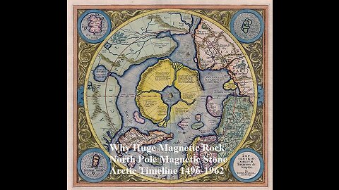
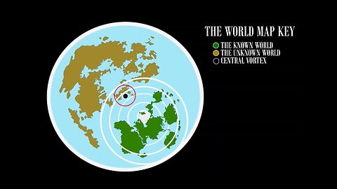
Magnetic Stone Rupes Nigra Huge Magnetic Rock 180km In Diameter At North Pole
What If Everything You Were Taught Was A Lie?This Is A Very Rare And Top Secrets Real Video From M.I.R. Space Station of the North Pole Septentrionalium Terrarum descriptio - Magnetic Stone The Rupes Nigra ("Black Rock") 1595 First Edition Mercator Map of the Arctic (1st Map of the North Pole) Hello my friends. this is an ancient map of the north pole. The North Pole as a magnetic mountain goes back at least to Roman times. the North Pole as a magnetic mountain surrounded by a circular continent divided by four powerful rivers from maps Martin Behaim's 1492 globe shows, at the arctic pole there is a high magnetic rock, thirty-three German miles in circumference. A surging sea surrounds this rock, as if the water were discharged downward from a vase through an opening. Around it are islands, two of which are inhabited." Mercator's map from 1595 showing the Arctic continent, with the "Rupes nigra et altissima" ('black and highest rock') at its centre. The Rock is the site of the North Pole, captioned as the POLVS ARCTICVS. Gerardus Mercator's world map of 1569 reflects his reading of Cnoyen's Itinerarium. It also features a marginal note alluding to the Franciscan's "discovery", "we have taken [the Arctic geography] from the Itinerium of Jacobus Cnoyen of the Hague, who makes some citations from the Gesta of Arthur of Britain; however, the greater and most important part he learned from a certain priest at the court of the king of Norway in 1364. He was descended in the fifth generation from those whom Arthur had sent to inhabit these lands, and he related that in the year 1360 a certain Minorite, an Englishman from Oxford, a mathematician, went to those islands; leaving them, advanced still farther by magic arts and mapped out all and measured them by an astrolabe in practically the subjoined figure, as we have learned from Jacobus.The four canals there pictured he said flow with such current to the inner whirlpool, that if vessels once enter they cannot be driven back by wind." The Arctic map inset on Mercator's 1569 world map was the prototype for the influential and widely circulated Septentrionalium Terrarum of 1595, posthumously published by his son, and the maps in Ortelius's Theatrum Orbis Terrarum of 1570. Both show the same configuration of the arctic regions as the 1569 map. In his letter to Dee, Mercator further quotes Cnoyen's description of the Northern regions: "...In the midst of the four countries is a Whirlpool into which there empty these four Indrawing Seas which divides the North. And the water rushes round and descends into the earth just as if one were pouring it through a filter funnel. It is 4 degrees wide on every side of the Pole, that is to say eight degrees altogether. Except that right under the Pole there lies a bare rock in the midst of the Sea. Its circumference is almost 33 French miles, and it is all of magnetic stone. And is as high as the clouds, so the Priest said, who had received the astrolabe from this Minorite in exchange for a Testament. And the Minorite himself had heard that one can see all round it from the Sea, and that it is black and glistening. And nothing grows thereon, for there is not so much as a handful of soil on it." More interesting to modern researchers are the people the friar encountered, "pygmies" who may well be identical with the Skrælings referred to in old Norse texts about Greenland, predecessors of the modern Inuit. The John Day letter In 1956 a letter referring to the existence of the book was found in the Archivo General de Simancas (Spain) from the English merchant John Day to "The Most Magnificent And Most Worthy Lord - The Lord Grand Admiral" (presumably Christopher Columbus). written in either December 1497 or January 1498, John Day says, "Your Lordship's servant brought me your letter. I have seen its contents and I would be most desirous and most happy to serve you. I do not find the book Inventio Fortunata, and I thought that I (or he) was bringing it with my things, and I am very sorry not [to] find it because I wanted very much to serve you. I am sending the other book of Marco Polo and a copy of the land which has been found [by John Cabot]… The Rupes Nigra ("Black Rock"), a phantom island, is believed to be a 33-mile-wide black rock (Mercator actually describes the rock's circumference as 33 "French" miles) located at the Magnetic North Pole or at the North Pole itself.It purportedly explains why all compasses point to this location.comes from a lost work titled Inventio Fortunata, and the island features on maps from the sixteenth and seventeenth centuries, including those of Gerardus Mercator and his successors.Mercator describes the island in a 1577 letter to John Dee: In the midst of the four countries is a Whirl-pool, into which there are empty these four indrawing Seas which divide the North. And the water rushes round and descends into the Earth just as if one were pouring it through a filter funnel. It is four degrees wide on every side of the Pole, that is to say eight degrees altogether. Except that right under the Pole there lies a bare Rock in the midst of the Sea. Its circumference is almost 33 French miles, and it is all of magnetic Stone [Jacobus Cnoyen] years ago. Gerard Mercator (March 5, 1512 - December 2, 1594) is a seminal figure in the history of cartography. Mercator was born near Antwerp as Gerard de Cremere in Rupelmonde. He studied Latin, mathematics, and religion in Rupelmonde before his Uncle, Gisbert, a priest, arranged for him to be sent to Hertogenbosch to study under the Brothers of the Common Life. There he was taught by the celebrated Dutch humanist Georgius Macropedius (Joris van Lanckvelt; April 1487 - July 1558). It was there that he changed him name, adapting the Latin term for 'Merchant', that is 'Mercator'. He went on to study at the University of Louvain. After some time, he left Louvain to travel extensively, but returned in 1534 to study mathematics under Gemma Frisius (1508 - 1555). He produced his first world map in 1538 - notable as being the first to represent North America stretching from the Arctic to the southern polar regions. This impressive work earned him the patronage of the Emperor Charles V, for whom along with Van der Heyden and Gemma Frisius, he constructed a terrestrial globe. He then produced an important 1541 globe - the first to offer rhumb lines. Despite growing fame and imperial patronage, Mercator was accused of heresy and in 1552. His accusations were partially due to his Protestant faith, and partly due to his travels, which aroused suspicion. After being released from prison with the support of the University of Louvain, he resumed his cartographic work. It was during this period that he became a close fried to English polymath John Dee (1527 - 1609), who arrived in Louvain in 1548, and with whom Mercator maintained a lifelong correspondence. In 1552, Mercator set himself up as a cartographer in Duisburg and began work on his revised edition of Ptolemy'sGeographia. He also taught mathematics in Duisburg from 1559 to 1562. In 1564, he became the Court Cosmographer to Duke Wilhelm of Cleve. During this period, he began to perfect the novel projection for which he is best remembered. The 'Mercator Projection' was first used in 1569 for a massive world map on 18 sheets. On May 5, 1590 Mercator had a stroke which left him paralyzed on his left side. He slowly recovered but suffered frustration at his inability to continue making maps. By 1592, he recovered enough that he was able to work again but by that time he was losing his vision. He had a second stroke near the end of 1593, after which he briefly lost speech. He recovered some power of speech before a third stroke marked his end. Following Mercator's death his descendants, particularly his youngest son Rumold (1541 - December 31, 1599) completed many of his maps and in 1595, published hisAtlas. Nonetheless, lacking their father's drive and genius, the firm but languished under heavy competition from Abraham Ortelius. It was not until Mercator's plates were purchased and republished (Mercator / Hondius) by Henricus Hondius II (1597 - 1651) and Jan Jansson (1588 - 1664) that his position as the preeminent cartographer of the age was re-established. Jodocus Hondius (October, 14 1563 - February 12, 1612) was an important Dutch cartographer active in the late 16th and early 17th centuries. His common name, Jodocus Hondius is actually a Latinized version of his Dutch name, Joost de Hondt. He is also sometimes referred to as Jodocus Hondius the Elder to distinguish him from his sons. Hondius was a Flemish artist, engraver, and cartographer. He is best known for his early maps of the New World and Europe, for re-establishing the reputation of the work of Gerard Mercator, and for his portraits of Francis Drake. Hondius was born and raised in Ghent. In his early years he established himself as an engraver, instrument maker and globe maker. In 1584 he moved to London to escape religious difficulties in Flanders. During his stay in England, Hondius was instrumental in publicizing the work of Francis Drake, who had made a circumnavigation of the world in the late 1570s. In particular, in 1589 Hondius produced a now famous map of the cove of New Albion, where Drake briefly established a settlement on the west coast of North America. Hondius' map was based on journal and eyewitness accounts of the trip and has long fueled speculation about the precise location of Drake's landing, which has not yet been firmly established by historians. Hondius is also thought to be the artist of several well-known portraits of Drake that are now in the National Portrait Gallery in London. In 1593, Hondius returned to Amsterdam, where he remained until the end of his life. In 1604, he purchased the plates of Gerard Mercator'sAtlasfrom Mercator's grandson. Mercator's work had languished in comparison to the rival atlas,Theatrum Orbis Terrarumby Ortelius. Hondius republished Mercator's work with 36 additional maps, including several which he himself produced. Despite the addition of his own contributions, Hondius recognizing the prestige of Mercator's name, gave Mercator full credit as the author of the work, listing himself as the publisher. Hondius' new edition of Mercator revived the great cartographer's reputation and was a great success, selling out after a year. Hondius later published a second edition, as well as a pocket version called theAtlas Minor. The maps have since become known as the "Mercator/Hondius series". Between 1605 and 1610 Hondius was employed by John Speed to engrave the plates for Speed'sThe Theatre of the Empire of Great Britaine. Following Hondius' death in 1612, his publishing work in Amsterdam was continued by his widow and two sons, Jodocus II and Henricus. Later his family formed a partnership with Jan Jansson, whose name appears on theAtlasas co-publisher after 1633. Eventually, starting with the first 1606 edition in Latin, about 50 editions of the Atlas were released in the main European languages. In the Islamic world, the atlas was partially translated by the Turkish scholar Katip Çelebi. The series is sometimes called the 'Mercator/Hondius/Jansson' series because of Jansson's later contributions. Hondius' is also credited with a number of important cartographic innovations including the introduction of decorative map borders and contributions to the evolution of 17th century Dutch wall maps. The work of Hondius was essential to the establishment Amsterdam as the center of cartography in Europe in the 17th century. This is the first edition, first state of Gerard Mercator's seminal 1595 map of the Arctic, the great cartographer's most interesting and important atlas map. In this first edition, it is the scarcest of Mercator's atlas maps and a holy grail for any Arctic collector. For all its flaws and inaccuracies, it is a schematized interpretation of factual voyages between Norway, England, Iceland, Greenland, and Labrador (Markland). Context of this Polar Projection Mercator's Arctic projection has its roots in a magnificent 1569 wall map of the world in which Mercator first introduces his revolutionary projection. The difficulty with the Mercator Projection is that it dramatically inflates the appearance of size it draws near to the poles: its application to the polar regions themselves would result in an infinitely tall map. Mercator therefore included a polar projection, very similar to the map shown here, in the lower-left corner of his wall map. Mercator produced the present map, expanded and updated from his wall map, for inclusion in the first edition of hisAtlas, published posthumously in 1595. As such, it is the first specific separate map of the Arctic. At the North Pole, Mercator depicts a large black rock, theRupes Nigra, surrounded by a great whirlpool fed by four powerful rivers - 'the Indrawing Seas'. These divide a massive continent-sized landmass into four distinct islands. When the English polymath John Dee wrote to Mercator asking about his sources for this map, Mercator returned the following letter which survives in his own hand (April 20, 1577, British Library): In the midst of the four countries is a Whirl-pool, into which there empty these four indrawing Seas which divide the North. And the water rushes round and descends into the Earth just as if one were pouring it through a filter funnel. It is four degrees wide on every side of the Pole, that is to say eight degrees altogether. Except that right under the Pole there lies a bare Rock in the midst of the Sea. Its circumference is almost 33 French miles, and it is all of magnetic Stone (…) This is word for word everything that I copied out of this author years ago. The author to which Mercator referred is the Dutch traveler Jacobus Cnoyen van Tsertoghenbosche, whose report combined firsthand encounters with interpretations of an enigmatic lost work, theInventio Fortunata(Fortunate Discoveries). This 14th century work, now largely forgotten, was a well-known resource for cartographers of the 15th and 16th centuries. The mysterious author may have been Nicholas of Lynn, Thomas Kingsbury, or Hugh of Ireland. The work told of a Minorite monk from Oxford who traveled extensively in northern lands, including Iceland, Greenland, Norway, and possibly even Labrador. TheInventioalso cited far older lost works, thePrincipio Gestorum Arturiand the Leges Anglorum Londoniis Collectae, which contributed a chapter to the legend of King Arthur, casting him as a 6th century Arctic explorer, and describing Arthurian conquests of Iceland, Greenland, the Faeroes, parts of Norway, and even the North Pole. King Arthur - Arctic Explorer TheInventiodescribed Arthur's invading Arctic army as consisting of some 4000 men on 12 ships. He sent the army into one of these 'indrawing seas', apparently the only way to bypass the 'Encircling Arctic Mountains'. According to John Dee, in Arthur's time there were cities lying beyond those mountains. Perhaps unsurprisingly, no further report of this momentous invasion appears in Arthurian record. In the fourteenth century, at the court of King Håkan Magnusson (1340 - 1380) in Norway, Cnoyen met and interviewed eight travelers from northern regions. One, a priest, even carried an astrolabe. Historian E. G. Taylor ('A letter dated 1577 from Mercator to John Dee.'Imago Mundi13:56–68) believed Cnoyen's voyagers were Norse settlers from 'Greenland, or even . . . a group from Markland (Labrador).' The combination of concrete voyager's reports with the tantalizing, remote voyages of a legendary king helped cement Mercator's formulation of the Arctic as he presented here. The Magnetic North The black rock at the pole, theRupes Nigra, also came to Mercator from Cnoyen, who reported that it was made of magnetic stone (an explanation the wonders of the compass). Mercator, however, did not ascribe toRupes Negrathe magnetic properties claimed by Cnoyen. Instead, Mercator placed a different magnetic rock to the north of the Strait of Anian, and it was this that he identified as the magnetic pole: an attempt to explain the correct observation that the geographic pole and the magnetic pole were not the same. Perilous Waters The placement, both by medieval scholars and Mercator, of violent currents and whirlpools in the northern waters was neither isolated nor fanciful. The Lofoten Maelstrom on the coast of Norway inspired many early legends, for example. The explorers John Davis and Martin Frobisher both believed the strong currents that they encountered corresponded to Mercator's polar rivers and their descriptions reflected such: This place seemeth to have a marvellous great indrafte, and draweth in to it most of the drift ice and other things which doe flote in the sea (George Best - Martin Frobisher's Lieutenant) which inlet or gulfe this afternoone and in the night we passed over: where to our great admiration we saw the sea falling down into the gulfe with a mighty overfal and roaring, and with divers circular motions like whirle-pooles. (James Davis) It is hard to know exactly what these navigators witnessed, but there can be no doubt that Arctic currents in Davis's Strait are powerful and erratic. Mercator wasnotin doubt: at the southern opening of Davis Strait, he noted in English,'a furious over fall.' Indigenous Peoples Throughout the map are references to remote Indigenous populations. These include the Samoyed people of Siberia (described here as cannibals), and theZolotaya Babaor 'Golden Woman,' an idol worshipped by indigenes on the Ob River. This probably derives from Sigismund von Herberstein's (1486 - 1566) 1557 map of Muscovy which included the idol. Ir is very likely that Herberstein's book informed Mercator's geography for Siberia, as did the small map of Maciej Miechowita (1457 - 1523). Further north, the Latin text on the island north of Norway notes 'Here live pygmies, at most 4 feet tall, who are like those in Greenland called Scraelings.' This may derive again from Cnoyen, but from his report of Norse travelers: the name 'Scraeling,' referring to the Inuit of Greenland, was a Viking term. It also appeared in the Sagas referring to abortive Viking efforts to colonize Vinland. Placing the Inuit on that particular Arctic island, neighboring Greenland, would be a reasonable assumption; after all, Mercator notes the presence of Scraelings in Greenland as well. Zeno anf Frisland The difficulty Mercator confronted in presenting a map of such remote regions is not just that the sources available to him were few, but that they could not be confirmed - resulting in the perpetuation of geographical information that was arguably concocted deceptively. Hence, his inclusion of the imaginary island of Frisland, which appears between Greenland and Iceland. Mercator's delineation of this region is drawn from the 1558 map of Nicolo Zeno the younger, informed by the purported explorations of his ancestors Nicolo and Antonio Zeno. The brothers Zeno allegedly explored the coasts of Greenland and Labrador in the 14th century, and as such were held forth as a Venetian discovery of America. Modern historical consensus has been that Nicolo the Younger's map was a hoax, with a minority of dissenters considering it a confused re-telling of a legitimate voyage. Some archival evidence places the Zeno brothers in Venice at the time they were supposedly at sea; it is possible that they never voyaged at all. Nevertheless, in the 16th century Zeno's map was accepted as legitimate. Warts and all, it represented the first attempt at mapping the remote north Atlantic, and so its many phantom islands - notably Frisland - would be included on the maps of Mercator and other cartographers well into the 17th century. Mercator thought Frisland important enough that he assigned one of three detail maps to it: the other two roundels portray the Shetland Islands and the Faroe Islands, respectively. (Iceland was afforded a full map to itself, so it is no outrage that it was not shown in greater detail here.) Drawing on Thevet and Cartier Mercator's mapping of North America is unique among his works. It features the 'Lago de Conibaz', a large lake with a central island and a river emptying far to the west into a great bay north of the Strait of Anian. The land directly south of the bay is named 'Bergi Regio,' while that to the north bears an astonishing Latin text reading (in translation), 'California region, known only to the Spanish.' This system bears no similarity to any other Mercator map of which we are aware. Mercator's 1569 world map obscured this whole area under a cartouche; its Arctic inset lacks Conibaz and its attached bay. Likewise, neither his 1595America sive India Novanor his son Rumold's 1587 world map include them. In all of these other maps, the whole region north ofAnian Regnumwas collectively referred to asBergi regio, and the California reference appearing here is repeated nowhere else. Lake Conibas, the attached bay and its rivers first appeared on the 1575 André Thevet map of America. (The system also appears, in slightly different form, on the 1593 De JodeAmericae Pars Borealis.) To include it here, Mercator bisected his 'Bergi regio,' moving that placename to the south. In doing so, he created a new peninsula north of the Arctic Circle, and it is this to which he applied the California text. (It appears unlikely that even the Spanish knew about this region, since it was probably entirely the creation of Mercator.) On the other hand, Conibaz and its attendant rivers represent an important passage of explorers' information to Mercator. Thevet is known to have met with Jacques Cartier (1491 - 1557), who explored the Saint Lawrence River and interacted with the Iroquoians. The term Conibaz may relate to 'Cornibotz' (Wampum shells). Cartier's report via Thevet appears to have been informed by his conversations with the Iroquois, and this reflects factual indigenous reports of the North American interior. Conibaz has been associated by some scholars with Great Salt Lake, Lake Ontario, or even the Great Lakes in general. Thus Mercator, and other cartographers had general knowledge of great inland lakes of North America long before Europeans actually encountered them. Still, Mercator's application of the term 'California' to a region north of the Arctic circle is baffling. The 1595Americauses the word only to refer to the tip of the Baja Peninsula; it does not appear prominently in his 1569 world map. (Ortelius's 1570 America would apply the name to the tip of Baja; his edited 1587 America used the term for the entire peninsula.) No other map of which we are aware uses the term as it appears here. The 1593 De Jode, although it includes Thevet's bay and Lake Conibaz, more appropriately places California to the south. It may be that Mercator was simply referring to the whole of Spain's discoveries on the West Coast as 'California,' and including the Arctic regions among them, but why then did he not do so in any other map? Revelations in Central Asia Opposite the American side of the Strait of Anian, is the Asian land of Gog, which appears bound in a tight ring of mountains. Gog and Magog, Biblical nations from the Book of Revelations, were associated by many Europeans with the Tartars. It was believed that Alexander the Great walled off the Kingdom of Gog and Magog behind a mountain range. Many early maps, following up on this legend as well as references from the journals of Marco Polo, place either Gog or Magog in the northeastern extreme of Asia behind an impenetrable mountain range. Publication History and Census This first state of Mercator's Arctic map was introduced in the 1595 first edition of Mercator'sAtlas sive cosmographicae…It bears the elder Mercator's imprint, and is attributed to him. (We note that the composition of this map, with its circular cartouche and insets, and acanthus borders, is reminiscent of the 1595America sive India Nova, which was engraved by Mercator's grandson Michael.) Jodocus Hondius, having acquired theAtlasin 1606, significantly altered and updated the plate. Examples of the Mercator/ Hondius second plate remained in the atlas until 1634, and various editions of that version of the map appear on the market from time to time. This 1595 first state is virtually unobtainable. CARTOGRAPHERS Gerard Mercator (March 5, 1512 - December 2, 1594) is a seminal figure in the history of cartography. Mercator was born near Antwerp as Gerard de Cremere in Rupelmonde. He studied Latin, mathematics, and religion in Rupelmonde before his Uncle, Gisbert, a priest, arranged for him to be sent to Hertogenbosch to study under the Brothers of the Common Life. There he was taught by the celebrated Dutch humanist Georgius Macropedius (Joris van Lanckvelt; April 1487 - July 1558). It was there that he changed him name, adapting the Latin term for 'Merchant', that is 'Mercator'. He went on to study at the University of Louvain. After some time, he left Louvain to travel extensively, but returned in 1534 to study mathematics under Gemma Frisius (1508 - 1555). He produced his first world map in 1538 - notable as being the first to represent North America stretching from the Arctic to the southern polar regions. This impressive work earned him the patronage of the Emperor Charles V, for whom along with Van der Heyden and Gemma Frisius, he constructed a terrestrial globe. He then produced an important 1541 globe - the first to offer rhumb lines. Despite growing fame and imperial patronage, Mercator was accused of heresy and in 1552. His accusations were partially due to his Protestant faith, and partly due to his travels, which aroused suspicion. After being released from prison with the support of the University of Louvain, he resumed his cartographic work. It was during this period that he became a close fried to English polymath John Dee (1527 - 1609), who arrived in Louvain in 1548, and with whom Mercator maintained a lifelong correspondence. In 1552, Mercator set himself up as a cartographer in Duisburg and began work on his revised edition of Ptolemy'sGeographia. He also taught mathematics in Duisburg from 1559 to 1562. In 1564, he became the Court Cosmographer to Duke Wilhelm of Cleve. During this period, he began to perfect the novel projection for which he is best remembered. The 'Mercator Projection' was first used in 1569 for a massive world map on 18 sheets. On May 5, 1590 Mercator had a stroke which left him paralyzed on his left side. He slowly recovered but suffered frustration at his inability to continue making maps. By 1592, he recovered enough that he was able to work again but by that time he was losing his vision. He had a second stroke near the end of 1593, after which he briefly lost speech. He recovered some power of speech before a third stroke marked his end. Following Mercator's death his descendants, particularly his youngest son Rumold (1541 - December 31, 1599) completed many of his maps and in 1595, published hisAtlas. Nonetheless, lacking their father's drive and genius, the firm but languished under heavy competition from Abraham Ortelius. It was not until Mercator's plates were purchased and republished (Mercator / Hondius) by Henricus Hondius II (1597 - 1651) and Jan Jansson (1588 - 1664) that his position as the preeminent cartographer of the age was re-established. Jodocus Hondius (October, 14 1563 - February 12, 1612) was an important Dutch cartographer active in the late 16th and early 17th centuries. His common name, Jodocus Hondius is actually a Latinized version of his Dutch name, Joost de Hondt. He is also sometimes referred to as Jodocus Hondius the Elder to distinguish him from his sons. Hondius was a Flemish artist, engraver, and cartographer. He is best known for his early maps of the New World and Europe, for re-establishing the reputation of the work of Gerard Mercator, and for his portraits of Francis Drake. Hondius was born and raised in Ghent. In his early years he established himself as an engraver, instrument maker and globe maker. In 1584 he moved to London to escape religious difficulties in Flanders. During his stay in England, Hondius was instrumental in publicizing the work of Francis Drake, who had made a circumnavigation of the world in the late 1570s. In particular, in 1589 Hondius produced a now famous map of the cove of New Albion, where Drake briefly established a settlement on the west coast of North America. Hondius' map was based on journal and eyewitness accounts of the trip and has long fueled speculation about the precise location of Drake's landing, which has not yet been firmly established by historians. Hondius is also thought to be the artist of several well-known portraits of Drake that are now in the National Portrait Gallery in London. In 1593, Hondius returned to Amsterdam, where he remained until the end of his life. In 1604, he purchased the plates of Gerard Mercator'sAtlasfrom Mercator's grandson. Mercator's work had languished in comparison to the rival atlas,Theatrum Orbis Terrarumby Ortelius. Hondius republished Mercator's work with 36 additional maps, including several which he himself produced. Despite the addition of his own contributions, Hondius recognizing the prestige of Mercator's name, gave Mercator full credit as the author of the work, listing himself as the publisher. Hondius' new edition of Mercator revived the great cartographer's reputation and was a great success, selling out after a year. Hondius later published a second edition, as well as a pocket version called theAtlas Minor. The maps have since become known as the "Mercator/Hondius series". Between 1605 and 1610 Hondius was employed by John Speed to engrave the plates for Speed'sThe Theatre of the Empire of Great Britaine. Following Hondius' death in 1612, his publishing work in Amsterdam was continued by his widow and two sons, Jodocus II and Henricus. Later his family formed a partnership with Jan Jansson, whose name appears on theAtlasas co-publisher after 1633. Eventually, starting with the first 1606 edition in Latin, about 50 editions of the Atlas were released in the main European languages. In the Islamic world, the atlas was partially translated by the Turkish scholar Katip Çelebi. The series is sometimes called the 'Mercator/Hondius/Jansson' series because of Jansson's later contributions. Hondius' is also credited with a number of important cartographic innovations including the introduction of decorative map borders and contributions to the evolution of 17th century Dutch wall maps. The work of Hondius was essential to the establishment Amsterdam as the center of cartography in Europe in the 17th century. SOURCE Mercator, G.,Atlantis Pars Altera, (Rumold Mercator) 1595. Mercator'sAtlasis one of the most important works in the history of cartography. Although in fact Ortelius was the first to publish a proper atlas, theTeatrum Orbis Terrarum, Mercator'sAtlasthe first book to employ the termAtlasfor a collection of maps. The term is derived both from the mythical titan, Atlas, who was forced to bear the world upon his shoulders, and the Libyan king, philosopher, and astronomer of the same name that, so the legend goes, constructed the first globe. Mercator dedicated the final 25 years of his life to compile theAtlas. He published two parts during his lifetime in 1585 and 1589, but the final part published posthumously by his son Rumold Mercator, in 1595. The map plates for theAtlaswere later acquired by Jodocus Hondius who published the most complete and well known edition in 1606. It was Jodocus who popularized theAtlasand who did the most to elevate Gerard Mercator's work. The North Pole, Land of Pygmies and Giant Magnets According to Mercator, the North Pole was marked by a giant black magnetic rock. Somewhere in the 14th century, a Franciscan from Oxford, a ‘priest with an astrolabe’, writes a travelogue about his discoveries in the North Atlantic, calls it the Inventio Fortunata (‘The Discovery of Fortunata’) and in 1360 presents it to the King of England. This book has been lost since the late 15th century. However, a Jacobus Cnoyen from the city of ‘s Hertogenbosch (in present-day Netherlands) summarizes the contents of the Inventio, related to him in 1364 in Norway by another Franciscan who had met the author. Cnoyen’s own travel-book is called the Itinerarium. https://en.wikipedia.org/wiki/William_of_Rubruck This book has also been lost. https://commons.wikimedia.org/wiki/File:Mercator_Septentrionalium_Terrarum_descriptio.jpg All this we know by the extensive quotes from the Itinerarium in a letter by the Flemish cartographer Gerhard Mercator to his friend, the English scientist, occultist and royal advisor John Dee. That letter, written in 1577 and now in the British Museum, mentions that: “In the midst of the four countries is a Whirl-pool, into which there empty these four indrawing Seas which divide the North. And the water rushes round and descends into the Earth just as if one were pouring it through a filter funnel. It is four degrees wide on every side of the Pole, that is to say eight degrees altogether. Except that right under the Pole there lies a bare Rock in the midst of the Sea. Its circumference is almost 33 French miles, and it is all of magnetic Stone (…) This is word for word everything that I copied out of this author (i.e. Cnoyen) years ago.” A giant magnetic rock, exactly at the North Pole… well, that would explain why all compasses point north, wouldn’t it? Alas, the ominous magnet (described in the letter as “black and glistening” and “high as the clouds”) is a bit too fantastic an explanation for the phenomenon of magnetism. For even back in the late 16th century, mariners often found that their compasses increasingly deviated from ‘true north’ as they approached it. But only later did the separate (and wandering) location of the magnetic poles become common knowledge. In the intervening Age of Exploration (and sometimes Fabulation), Mercator cites an author who clearly hadn’t seen the North Pole with his own eyes – nor had the author he quoted, nor in fact would anyone for centuries to come. In the meantime, the invented geography in the Inventio Fortunata that came to us via that one letter greatly influenced cartographers’ views of the Arctic region. For if no other knowledge of yet-undiscovered lands is available, there’s really not much argument against unbelievable stories. And so, the Black Cliff, the four countries and the whirlpool are evident in Martin Behaim’s globe (1492), which predates Mercator’s map. In 1956, a letter surfaced written by the English merchant John Day in 1497 or 1498 to ‘the Lord Grand Admiral’ (probably Columbus), with Day expressing regret that he hadn’t been able to find the Inventio Fortunata for him. In a marginal note on one of Johannes Ruysch’s maps (from 1508), the Dutch cartographer even mentions that two of the continents surrounding the North Pole are inhabited. Mercator’s late-16th-century Arctic map (Septentrionalium Terrarum, ‘Of the Northern Lands’) was the first ever to be centred on the North Pole itself. It was a mix of fact and fiction, showing some recent discoveries but also the four fanciful countries surrounding the Arctic whirlpool with in its middle the Rupes Nigra et Altissima (‘Black and Very High Cliff’), supposedly responsible for animating navigators’ compasses. On the subject of mixing fact with fiction, Mercator incongruously includes in his map two other magnetic poles, along the 180° meridian, indicating that he did know of the magnetic deviation from the ‘true North’, but wasn’t yet prepared to ditch the preceding fabulation (thanks to Greg for pointing this out). Mercator’s map was included in the last of three volumes constituting his ground-breaking work (the first geographic tomes to be called an Atlas). The cartographer didn’t live to see it published: the last volume was brought out by his son Rumold in 1595, the year after his death. In 1604, cartographer Jodocus Hondius acquired the printing plates of Mercator’s Atlas, and over the years improved on the Arctic map (and others) as explorers and whalers came back with ever more accurate descriptions of the coastlines, in the case of the Arctic map especially those of Spitsbergen and Nova Zembla (also, and more correctly known as Novaya Zemlya, ‘New Land’ in Russian). Mercator’s authoritative (but wrong) depiction of the North Pole persisted well into the 17th century, only to be dispelled gradually by real discoveries. On the map, the Rupes Nigra can be seen surrounded by the four countries, all of which are labelled with Latin texts, some of which I can make out: • The island on the bottom right is labelled: Pygmei hic habitant & ad summum pedes longi quem admodum illi quos in Gronlandia Screlingers vocant. Which translates as something like this: ‘Here live Pygmies and (something about long feet), like those in Greenland that are called Skraelinger’. The island to the north of Pygmy-land is labelled: Hic euripus habet ostia et propter angustiam ac celerem fluvium nunquam congelatur. Which goes something like this: ‘This narrow channel has a harbour and due to its narrowness and swift current never freezes’. A glance at the North Pole and its mythology, from whirlpools and giants to the indrawing sea and the Rupes Nigra. https://www.arcus-atlantis.org.uk/horizons/magnetic-north.html HYPERBOREA was a fabulous realm of eternal spring located in the far north beyond the home of the north wind. Its people were a blessed, long-lived race untouched by war, hard toil and the ravages of old age and disease. Hyperborea was usually described as a continent-bound land bordered on the north by the great, earth-encircling river Okeanos (Oceanus), and on the south the peaks of the legendary Rhipaion (Rhipaean) Mountains. Its main river was the Eridanos whose banks were lined with amber-weeping poplar-trees and its waters home to flocks of white swans. Blessed with eternal spring, the land producing two crops of grain per year, but most of the countryside was wild and covered with beautiful forests--the so-called "garden of Apollon." The southern border of Hyperborea was guarded by the bitterly cold peaks of the impassable Rhipaion (Rhipaean) mountains--home to Boreas (the North Wind) whose chill breath brought winter to the lands of the south. Its peaks were inhabited by gold-guarding Grypes (Griffins) and its valleys by the fierce, one-eyed Arimaspoi tribe. Beneath the southern slopes lay Pterophoros--a desolate, snow-covered land cursed with eternal winter. Hyperborea was a theocracy ruled by three priests of the god Apollon. These gigantic kings, known as the Boreades, were sons of Boreas (the North Wind). Their capital contained a circular temple dedicated to the god where hecatombs (a hundred-head) of asses were sacrificed in his honour. The people also celebrated their god in an eternal festival of music, song and dance whose hymns were joined by the sweet song of the circling Hyperborean swans. The realm plays a role in several myths. Phaethon tried to drive the chariot of the sun but lost control and was struck down by Zeus, sending his flaming body plummeting into the Hyperborean river Eridanos. His mourning sisters, the Heliades, were afterwards transformed into amber-shedding poplar trees on its banks, and his grief-stricken friend Kyknos (Cycnus) into a swan. Elderly Hyperboreans commemorated the event by leaping into the lake formed by Phaethon's fall to be transformed into white swans. Perseus later travelled to Hyperborea and was entertained by its folk when he was searching for the Nymphs who guarded the treasures of the gods, or else the Graiai--swan-bodied hags who could reveal the location of Medousa. Perseus' descendant Herakles made the same journey on two separate occassions. The first time was in his quest for the golden-horned deer of Artemis which fled north during the chase. The second time he sought Atlas and the golden apples of Hesperides. Another body of stories describes Hyperboreans as pilgrim-founders of several important Greek shrines. The Delians told a tale of how the pregnant goddess Leto came to the island from Hyperborea accompanied by a pack of wolves where she gave birth to Apollon with the assistance of Eileithyia who was summoned from the northern realm to further the labour. After this event, the Hyperboreans sent pilgrims to the island--five men and several maiden-priestesses. However, after several of the maidens were either raped or killed, the Hyperboreans ended the pilgrimage and instead delivered their offerings indirectly through neighbouring tribes and peoples. The next major shrine connected with the Hyperboreans was the oracle of Apollon at Delphoi. The second of the early, mythical temples of the shrine was said to have been built by Hyperborean pilgrims out of beeswax and feathers. When the army of the Gauls tried to seize the temple in historical times, phantoms of these prophets were said to have appeared on the battlefield, routing the army. Finally they appear in the myths of the founding of the Olympic Games. It was said that when Herakles--either the Daktylos or the son of Zeus--established the festival in honour of Zeus he made a pilgrimage to Hyperborea to obtain sacred wild olives for the shrine. The most famous prophet of the Hyperboreans was probably Abaris who was given a magical arrow by the god Apollon on which he flew around the world performing miracles. Some say this arrow was the one which Apollon had used to slay the Kyklopes (Cyclopes) which had been hidden beneath a Hyperborean mountain. An Arctic Timeline : 1496-1962 The exploration of the North has extended over five hundred years and rather than finding a northwest passage to the eastern trade, it discovered a great fur trade and valuable fisheries, and even great oil fields. Early crews were often separated from their homes for years and some never returned. While hopes of finding a northwest passage was the initial objective, the ice conditions discouraged expectations of success. In the past, the problems of reaching the North Pole have been subordinate to the hope of finding, via that route, a water way to the east, and though the early north polar attempts failed in their main purpose, they resulted in the discovery of new lands and industries. Traveling in vulnerable wooden ships first powered only by sails, they gradually changed to powerful new and innovative vehicles and a commercial trade in the north was established. But even from the beginning of polar exploration the ships that sailed with orders to attain the North Pole have been in number and importance the exception, not the rule. Attempts to reach the North Pole itself followed using stronger ships with newer designs as a base for the dashes to the almost mythical prize. Balloons and the new dirigibles were tried, followed by airships and submarines. When the Pole itself was finally reached, it proved to be a vain goal since it was just a point on the ice above a moving body of water. The oceans of the Arctic basin and the frozen lands around it are now recognized as important study areas, and over the years virtually all exploration parties became directed toward studies of some kind. 1496: Henry VII granted "Letters patent" to John Cabot and his three sons to make voyages of discovery in "northern, eastern or western seas." The original charts and manuscripts of John Cabot and his son Sebastian have, for the most part, disappeared. 1576: Martin Frobisher's first voyage. An attempt would be made to reach Cathay through a passage to the northwest. Vessels used were two small barks, MICHAEL and GABRIEL. Frobisher, aboard the GABRIEL, crossed (now) Davis Strait between Greenland and (now) Baffin Island. They explored the vicinity of (now) Frobisher's Bay. They encountered Inuit, described as being "like to Tartars, with long blacke haire, broad faces and flatte noses and tawnie in colour, wearing Seale skinnes, and so doe the women, not differing in the fashion, but the women are marked in the face with blewe streekes downe the cheekes, and round about the eyes." On this first expedition, a rock was picked up as a souvenir in Frobisher's Bay and upon the expedition's return, the rock was assayed and said to contain gold. 1577: Martin Frobisher's second voyage to (now) Frobisher's Bay, under the auspices of the Cathay Company. The expedition was to continue the search for the Northwest Passage and to mine more of the 'gold'-bearing ore discovered the year before. The expedition remained in the bay for five weeks from 17 July to 23 August 1577 and mined about 200 tons of the ore. The AYDE, MICHAEL and GABRIEL returned to England, bringing an Eskimo man (Kalicho), woman (Arnaq) and child (Nutaaq) to Bristol. The man and woman died and were buried at St. Stephen's Church while the child died in London and was buried at St. Olaves, Hart Street. 1578: Martin Frobisher's third voyage to the Arctic. Commanding the AYDE, Frobisher led a fleet of fifteen vessels to (now) Frobisher's Bay. Over 100 miners from Cornwall and the Forest of Dean were to form a wintering party on a small island under the leadership of Captain Edward Fenton. Poor weather prevented the fleet from keeping together. Frobisher, together with several other vessels, sailed up what he called the "Mistaken Straightes," now called Hudson Strait. Most of the fleet was eventually reunited in the region where 1200 tons of "black ore" was extracted and loaded onto the ships. Upon their return to England, the ore proved to be worthless and the Cathay Company went bankrupt. Frobisher did not return to the Arctic but did retrieve his reputation firstly with Drake in the West Indies and later by his conduct as one of the main commanders of the English fleet that defeated the Spanish Armada of 1588. 1585: John Davis's first voyage in search of the Northwest Passage. The expedition, aboard the two small vessels SUNSHINE and MOONSHINE, made its first northern landfall on the east coast of Greenland. They sailed across (now) Davis Strait to (now) Baffin Island. They came ashore at (now) Cumberland Sound where two sledges were discovered "made like ours in Englande." Despite signs of inhabitants, none were encountered. 1586: John Davis's second voyage to the Arctic. The vessels MERMAID, SUNSHINE, MOONSHINE and pinnace NORTH STAR sailed up the west coast of Greenland and encountered the "people of the country" in the vicinity of Gilbert Sound, later named Godthaab Fiord. In August, they sailed westwards from Greenland, finding land on southeast Baffin Island. Two of the ship's company were surprised and killed by the "Savages" ashore. 1587: John Davis's third voyage toward the Northwest Passage. Sailing aboard the barks SUNSHINE, ELIZABETH and the pinnace ELLEN, Davis and his crews traveled up the west coast of Greenland, trading with the Greenlanders as they went. After reaching the relatively high latitude of 72° 12' North, Davis turned to the west and sighted Cumberland Sound on Baffin Island which he discovered on his first voyage. They coasted the south shore of Cumberland Sound and re-entered Davis Strait in latitude 64° North. They continued south with the Labrador current, passing a "very great gulfe" which was no doubt Hudson Strait. Upon reaching the vicinity of Labrador, they set sail across the Atlantic for Dartmouth. 1602: George Waymouth, sent by the East India Company, may have proceeded along Hudson Strait for a good distance. His vessel, DISCOVERY, is one of the earliest of a line of exploring ships bearing that name. 1610: Henry Hudson, aboard DISCOVERY, sailed westward for 450 miles through a long strait and into a great bay, both of which now bear Hudson's name. Hudson turned south and the vessel was forced to winter at the southern end of the bay because of ice. They escaped from the ice in June 1611 but soon afterwards a mutiny took place after which Hudson, his son, the sick and the Hudson loyalists were all set adrift in a boat. They were never seen again. Two of the mutineers were killed by the Eskimos at the western end of Hudson Strait while many others died on the voyage home. Stories related by the survivors were believable so all were left unpunished. 1611: Thomas Button sailed on the RESOLUTION, with the DISCOVERY in company. This voyage was to follow-up Hudson's discoveries. Two of the mutineers on Hudson's expedition, Prickett and Bylot, were among the ship's company. Part of the west coast of Hudson Bay was charted and Port Nelson, where they wintered-over, was named after one of the mates who was buried there. The RESOLUTION was crushed by the ice and sank. The DISCOVERY sailed north to what was called Sir Thomas Roe's Welcome, between Southampton Island and the east coast of America, before turning for England. A considerable length of coastline was charted on this expedition. It was also determined that no westward passage from Hudson Bay existed. 1615: Robert Bylot and William Baffin, in the DISCOVERY, sailed through Hudson Strait but found no passage northward through what became known as Frozen Strait. 1619-20: Backed by the King of Denmark, Jens Munk fails to discover the Northwest Passage. His two ships wintered near the site of the later Hudson's Bay Company post, Fort Prince of Wales, on the Churchill River. 1631-32: Two independent voyages are made through Hudson Strait and into Hudson Bay in a further attempt to find a northwest passage through this route. Captain Thomas James commanded the HENRIETTA MARIA while Captain Luke Foxe commanded the CHARLES. James Bay, at the head of Hudson Bay, and Foxe's Channel were named after the two captains. 1668: The small vessel NONSUCH sails from London through the Hudson Strait and into Hudson Bay. Her voyage opens a sea route for trade in furs with the local Indians. 1670: By royal charter, incorporation of the Hudson's Bay Company is established. King Charles II appoints his nephew, Prince Rupert, their Governor and grants the "sole trade and commerce of all those Seas Streightes Bayes Rivers Lakes Creekes and Soundes in whatsoever latitude they shall bee that lye within the entrance of the Streightes commonly called Hudson's Streightes, together with all the Landes and Territorys upon the Countryes Coasts and confynes of the Seas Bayes Lakes Rivers Creekes and Soundes aforesaid that are not actually possessed by or granted to any of our Subjectes or possessed by the Subjectes of any other Christian Prince or State." The vast territory, to be known as Rupert's Land, would comprise nearly 40% of modern Canada. Three wooden forts are built on James Bay in 1685. 1719: Provisioned by the Hudson's Bay Company, elderly Captain James Knight leads two ships in search of "minerals and to traverse the 'Strait of Anian.'" This was a mythical strait attributed to unreliable charts and globes of the time. They departed from Gravesend on the lower Thames in June 1719 and were never seen again. 1741-42: Commanded by Captain Christopher Middleton, the FURNACE and DISCOVERY sail for Hudson's Bay on June 8, 1741. The vessels winter at Sloop Cove, between the Hudson's Bay Company's fort, named after the Prince of Wales, and the recently vacated Old Factory on the Churchill River. The expedition set sail the following year towards the north where they navigated the uncharted and ice-infested waters of Sir Thomas Roe's Welcome (now Roe's Welcome Sound), between the west coast of Southampton Island and the east coast of North America. They reach a deep bay whose upper reaches touch the Arctic Circle. Middleton names it Repulse Bay as there was no passage there. 1746-47: An attempt to find the Northwest Passage is privately organized by Arthur Dobbs, a member of the Irish House of Commons. The expedition is supported by a group of merchants who form the North West Committee. Commanded by William Moor in the DOBBS and Francis Smith in the CALIFORNIA, the expedition "carried out some useful exploration in difficult conditions, but ... every move, it seemed was dogged by disagreement, ineptitude and controversy." 1770-72: On behalf of the Hudson's Bay Company, the Governor of Fort Prince of Wales, Moses Norton, instructs Samuel Hearne to find and trace the Coppermine River to ascertain whether or not a route exists from Hudson Bay to the Pacific Ocean via the continent of North America. According to the Orders and Instructions, Hearne is "to trace to the mouth, and there determine the latitude and longitude as near as you can; but more particularly so, if you find it navigable, and that a settlement can be made there with any degree of safety, or benefit to the Company." Hearne was accompanied by a group of Northern (Chipewyan) Indians, led by a chief named Matonabbee. The successful journey departed on December 7, 1770 with the women carrying heavy loads together with their infants. Meanwhile, the men hunted and sometimes ate while the women went hungry. They reached the Coppermine River on July 14, 1771 but found the river too dangerous to navigate. On July 17 they surprised a group of Inuit fishing on the river. The Chipewyan Indians showed no mercy towards the Inuit, massacring them and destroying their tents, kettles and every other provision necessary to sustain life in this harsh environment. Shortly after the massacre, Hearne reaches the mouth of the river. He found the vicinity "full of islands and shoals" with unbroken sea ice off in the distance. The tide was out so the water tasted fresh but the bones of whales and sealskins at the Eskimo encampment convinced him that he had reached the "Northern Ocean." As a consequence, he became the first European to accomplish this feat. The significance of this expedition was to prove that no passage existed through the American continent south of the Arctic Circle. 1776-80: Captain James Cook's third voyage of discovery, commanding HMS RESOLUTION and HMS DISCOVERY, with the object of finding the Northwest Passage via the Pacific Ocean. Unfortunately, "armchair cartographers" had drawn their maps and charts from theory, rather than surveys, which frustrated Cook and his officers while coasting southern Alaska. Cook's ships penetrated as far as Icy Cape on the coast of Alaska. This route into the Arctic, forged by the RESOLUTION and DISCOVERY, would later be taken by the ships of the Royal Navy. 1789: Alexander Mackenzie, a young partner in the North West Company, is driven by the need for a trading route to the Pacific after being displaced from the vicinity of Detroit due to the American Revolution. Mackenzie is accompanied by four French Canadian voyageurs, a Chipewyan Indian by the name of "English Chief," a number of Indian's wives and a young German, John Steinbruck. The expedition departs from Fort Chipewyan, on the southern shore of Lake Athabasca, on June 3, 1789. They reach a great river (subsequently named after Mackenzie), extending northward from the Great Slave Lake. The river is followed all the way to the Arctic Ocean which is reached on July 14, 1789, the same date as the outbreak of the French Revolution. 1792-94: Captain George Vancouver explores and surveys the northwest coast of America. It is subsequently proven that no navigable waterway exists between the Pacific and Atlantic oceans in temperate latitudes. 1817: William Scoresby, a young whaling captain and son of William Scoresby, Sr., inventor of the crow's nest, makes a voyage to Greenland where he finds "2000 square leagues of the surface of the Greenland Sea, between the parallels of 74° and 80° North, perfectly void of ice which is usually covered with it." 1818: In command of the ISABELLA, John Ross makes his first voyage in search of the Northwest Passage. Lt. Edward Parry, second in command, accompanies Ross in the ALEXANDER. Astronomer on the expedition is Captain Edward Sabine. They turn back at Lancaster Sound. 1819: In command of the DORTHEA, David Buchan seeks the North Pole via Spitzbergen. Lt. John Franklin is second in command aboard the TRENT. 1819-20: In command of the HECLA, William Edward Parry leads his first expedition in search of the Northwest Passage. Lt. Matthew Liddon is second in command aboard the GRIPER. A Parliamentary Act passed in 1818 "authorized the [payment of] ... five thousand pounds to the officers and men of the first ship to cross the 110th meridian of west longitude to the north of America by sailing within the Arctic Circle." Parry was the first to qualify when they proceeded westwards along what is now called Parry Channel, passing 110° West longitude in September 1819. They subsequently reach and name Melville Island after the First Lord of the Admiralty. 1819-21: In conjunction with Edward Parry's voyage, John Franklin leads his first overland expedition to Point Turnagain, in search of the Northwest Passage. The expedition ends in disaster with eleven members of the expedition losing their lives. 1821-23: In command of the FURY, Edward Parry leads his second voyage in search of the Northwest Passage. Second in command is George Lyon aboard the HECLA. The ice master of the HECLA dies of scurvy. 1824-25: Once again HECLA and FURY sail north under Edward Parry's command in search of the Northwest Passage. This, Parry's third voyage, would prove to be his final voyage to the Canadian Arctic. The FURY is grounded during a storm on July 30, 1825 and subsequently abandoned on Fury Beach at Somerset Island. 1825-27: John Franklin's second land expedition to the mouth of the Coppermine River. Together with John Richardson, he explores and maps more than a thousand miles of coastline from Coronation Gulf to Icy Cape, Alaska. 1827: On June 1, Edward Parry, aboard HECLA, leaves Spitzbergen on an attempt to reach the North Pole. Second in command is James Clark Ross. He reaches 82° 45' North and establishes a Farthest North that will stand for 50 years. 1825-28: The Admiralty dispatches BLOSSOM to the north Pacific. The expedition, under the command of F.W. Beechey, is instructed to await the emergence of Parry's HECLA and FURY into the north Pacific. Also anticipated is the arrival of Franklin's boats from his overland expedition. They reach Captain Cook's Icy Cape and proceed along the coast. Point Barrow is discovered and named after Sir John Barrow of the Admiralty, "to mark the progress of northern discovery on each side of the American continent which has been so perseveringly advocated by that distainguished member of our naval administration." 1829-33: John Ross's second expedition in search of the Northwest Passage. The expedition is privately sponsored by gin merchant Felix Booth. With the help of Eskimos, Ross and his crew survive through four Arctic winters. 1833: George Back, together with Richard King, leads an expedition to the Great Fish River in search of John Ross. 1837-39: A Hudson's Bay Company overland expedition is led by Peter Dease and Thomas Simpson. They survey most of the remaining unknown areas of the Northwest Passage. 1845-47: Tragedy befalls John Franklin and his men as he commands EREBUS and TERROR on a search for the Northwest Passage. Franklin is last seen by a whaling ship on June 25, 1845. Neither he nor any of the other 128 men would be seen alive again. Between 1848 and 1859 more than 50 expeditions are mounted to find him, with enormous sums of money spent on the search. The British Government spent approximately £675,000, Lady Franklin £35,000, the United States Government $150,000 and Henry Grinnell, president of the American Geographical Society, $100,000. 1848: The search for the Franklin expedition begins early in 1848. The First Lord of the Admiralty offers £10,000 to anyone who can merely discover what happened to Franklin and his lost ships, EREBUS and TERROR. The Admiralty proposed a 3-pronged attack from the east, west and south to find Franklin: two ships would enter the archipelago from the east by way of Lancaster Sound and Barrow Strait and then move west to Melville Island and Banks Land and then proceed south. (See James Clark Ross below). Two more ships would sail around Cape Horn hoping to rendezvous that July in Bering Strait to explore the western Arctic. (See Pullen below). Finally, a land expedition would travel to the Canadian northwest and follow the Mackenzie River north to the Arctic coast and then eastward along the rim of Wallaston Land and Victoria Land (See John Richardson below). It was expected that both of the naval expeditions would meet up with the land expedition. 1848-49: James Clark Ross, now at the end of his career, is instructed to follow Franklin's route through Barrow Strait and then south or southwest in search of the lost expedition. His two senior officers, Leopold M'Clintock and Robert McClure, will become Arctic heroes. The expedition ships, ENTERPRISE and INVESTIGATOR, are blocked by impassable ice north of Somerset Island. They are frozen in for eleven months at Port Leopold on the northwest tip of the island. They return to England, both officers and men having suffered badly from scurvy. Six of his company of sixty-four die on the expedition. 1848-51: John Richardson, at the age of sixty, leaves his family and embarks from Liverpool for North America in search of his old friend, John Franklin. Dr. John Rae is second in command of the overland expedition. After lodging together at Fort Confidence during the winter of 1848-49, Richardson returns to England, leaving Rae to follow the Mackenzie River to the Arctic coast and then explore eastward along the rim of Wallaston Land and Victoria Land. On Rae's third journey into the Arctic (now 1851), he proves that Wallaston Land and Victoria Lands are actually one and the same. Two fragments of wood are found that clearly came from a Royal Navy vessel. It would be years before anyone realized that they were most certainly from one of the Franklin expedition ships. 1848-51: Lt. W.J.S. Pullen commanding the expedition vessel HMS HERALD, together with the PLOVER and NANCY, reach Bering Strait. From here, he commands 5 small boats in an effort to go east, exploring the Arctic coastline to the Mackenzie Delta. See Rest Of The Text In This Post Part Two. Why Huge Magnetic Rock North Pole Magnetic Stone An Arctic Timeline 1496-1962 https://rumble.com/v3e30gf-why-huge-magnetic-rock-north-pole-magnetic-stone-an-arctic-timeline-1496-19.html Why Huge Magnetic Rock North Pole Septentrionalium Terrarum descriptio - Magnetic Stone The Rupes Nigra ("Black Rock") 1595 First Edition Mercator Map of the Arctic (1st Map of the North Pole) Hello my friends.9.04K views 9 comments -
Daylight Debunks the Globe detailed illustration of this, imagine the Sun 2020 ?
What If Everything You Were Taught Was A Lie?One simple and definitive proof that you are not living on a spinning ball orbiting around the Sun is the fact that daytime and nighttime never switch places as they must for the heliocentric model to be true. According to the globe doctrine, Earth makes one complete rotation on its axis every 24 hours, while simultaneously orbiting around the Sun and completing one full revolution every 365 days. If this was truly happening however, as you can see from the following image, the daytime and nighttime sides of the globe would have to flip every 6 months. For a more detailed illustration of this, imagine the Sun rising at 6am in New York on the Summer solstice. After 3 months of 24 hour rotations, the globe would be 90 degrees from its previous position and a quarter turn away from the Sun, meaning that sunrise in New York during the Autumnal equinox should now be happening at midnight. After 3 more months of 24 hour rotations, the globe would be on the complete opposite side of the Sun, 180 degrees from its starting position, so that sunrise in New York during the Winter solstice should be happening at 6pm, or in other words, daytime and nighttime would have completely flipped from 6 months earlier. After 3 more months of 24 hour rotations, the globe would be 270 degrees from its original position, and sunrise in New York during the Spring equinox should be happening at noon.282 views -
Tree Of Life 4 Waters Enoch 26-32 Garden Of Eden At The North Pole Genesis 2:10-14
What If Everything You Were Taught Was A Lie?Was the Garden of Eden at the North Pole ? Where was the Garden of Eden ? Hyperborea is a legendary land in Greek mythology, located to the far north of the known world, beyond the North Wind. This tree of life and or this tree is of ineffable goodness and fragrance...Its root is in the garden at the Earth’s end. And Paradise is between corruptibility and incorruptibility. Hyperborea was a fabulous realm of eternal spring located in the far north beyond the home of the north wind. Its people were a blessed, long-lived race untouched by war, hard toil and the ravages of old age and disease. And two springs come out... and they separate into four parts, and go round with quiet course, and go down into the Paradise Of Eden, between corruptibility and incorruptibility. And thence they go forth along the Earth, and have a revolution to their circle even as other Elements. And here there is no unfruitful tree, and every place is blessed. - II Enoch 8:3-8 Religious scholars have spent thousands of years looking for the Biblical paradise. Commonly, scholars suggest that any potential real-world model for Eden existed at the head of the Persian Gulf where the Tigris and Euphrates once met the Persian Karun River and the now-vanished Wadi Al-Rummah that once emptied into the Persian Gulf. This would therefore correlate both with the four rivers of Eden described in Genesis as well as the proposed location of the Mesopotamian paradise called Dilmun. However, others have proposed locations ranging from China-India to Georgia Guide-stones, in Elbert County, Georgia. The Garden of Eden had to be removed from Earth to spare it from the flood, to serve as a holy dwelling place for those ultra-righteous, like Enoch and Melchizedek and their cities, who were given access to the Tree of Life there so as not to fall victim to death until their transformation by resurrection to glory. ! The Garden of Eden is in a heaven between God's residence and Earth and will rejoin Earth at the parousia and meld with the New Jerusalem that will be stand through Christ's millennial reign. The New Jerusalem will be taken just before Earth passes away to spare it from destruction so that it can descend again to the New Earth described at the end of John's Revelation. Today I’d like to discuss one of the more fanciful suggestions, which attracted a scholarly hearing at the end of the nineteenth century. In Paradise Found (1885), the Rev. William F. Warren, president of Boston University, proposed a startling new theory about the location of Eden, “that the cradle of the human race, the Eden of primitive tradition, was situated at the North Pole, in a country submerged at the time of the Deluge.” His evidence for this claim ranged from the improbable to the ridiculous, as judged in the light of modern science, but in his time scholars had not yet discovered two essential facts that we know today: (a) that there is no land mass hidden beneath the arctic ice cap, and (b) that the ice has been in place since before the emergence of human beings. So much for his geographic, botanical, and zoological evidence, which he though sealed the case that the Arctic had once been a tropic paradise and the place from which all life evolved. More interesting is his claim for comparative mythology, which begins, as all fringe history books must (even when written by seemingly mainstream scholars), with the assertion that “the cosmology of the ancients has been totally misconceived by modern scholars” and that our author has some unique insight that gives him special knowledge of the truth. He begins by disputing that the ancients viewed the world as a flat plane surmounted by a metal or clay vault, in apparently willful contradiction of the plain reading of ancient texts (Enuma Elish 4.137-138, Iliad 17.425, Odyssey 15.329, Genesis 1:6-8, 3 Baruch 3:7, etc.). Instead, he claims that the ancients viewed the earth as a sphere in which the gods lived in the stars above the North Pole, humans in the northern hemisphere, the dead in the southern hemisphere, and demons in the stars below the South Pole. He is here literalizing the ancient concept of stacked planes and applying them directly to the earth itself. He goes on to literalize the concept of the world axis (around which the stars revolve) as twin mountains rising from the poles. This interpretation, though, is more a difference of form rather than a difference in kind. Flat or curved, the result isn’t really all that different except in one detail: By asserting that the ancients knew the earth to be round, it makes north more than just a direction on a map and lets Warren revise the Islands of the Blessed (in the west) and Eden (in the east) to correspond with the polar paradise in the north imagined as Hyperborea and Ultima Thule, and the world axis with the North Pole, despite Hindu cosmology placing Mount Meru in “the middle of the earth,” the Canaanites claiming it to be Mt. Hermon, and so on—after all, relative to the observer, the stars appear to spin high above any spot on earth, not specifically the North Pole. By collapsing mythic variation into the physical reality of geography, he makes every myth into the North Pole, washing away contradictory evidence as corruption or misinterpretation. He also has difficulty accepting the ambiguity of ancient versions of the underworld (probably due to divergent traditions), where the land was accessible both by descending into the earth and by crossing the River Ocean, instead asserting that such a land could only be the southern hemisphere. He concludes that the aurora borealis gave rise to the myth of a polar paradise blessed by God since the lights would have been taken as evidence of the divine abode of the gods in the memory of the descendants of the polar peoples. Warren received some interesting support. William Gladstone, Homeric scholar and British prime minister, endorsed part of his idea because it conformed to his own idea of Homeric cosmology, and professors of various ancient languages, cultures, and religions endorsed his reading. This isn’t really important. What is important is Warren’s claim, first expressed in an earlier book called The True Key to Ancient Cosmology and Mythical Geography (1882), which focused on Homer, that Atlantis “must be looked for, not between Europe and America, but at the pole, whither all the oldest ethnic traditions point us for the cradle of the human race.” While expressed in a footnote, he would expand upon it for the later book. There, he identified Atlantis with the Garden of Eden, and he asserted that both “were precisely where the tradition” of the ancients placed them: the North Pole. He does so by identifying Atlantis with Hyperborea (on the faulty claims of Noah’s Ark theorist Jacob Bryant, citing Pindar [Pythian 10], who said no such thing) and the charmed, long, and leisurely lives of the Hyperboreans (Pliny, Natural History 4.26) with the sinless world of Eden. You will, undoubtedly, recognize the core of this claim. Although modern science makes a tropical continent at the North Pole impossible, modern fringe writers can’t let an old claim die. Rand and Rose Flem-Ath, in When the Sky Fell (1995), invert it, though apparently without knowledge of the original, basing their work on Charles Hapgood and the earth crust displacement theory. In 2004, Robert Argod wrote Out of Antarctica which more explicitly recycled Warren’s claims. He used the same evidence that Warren had—claims of tropical plants and warm-weather myths—but moved everything to Antarctica (the South Pole). Graham Hancock, of course, famously embraced the Antarctica-as-Atlantis theory for a time before the sheer weight of geological fact forced him to amend his views. But surely the silliest application of the theory has to be in Raymond Bernard’s 1964 opus The Hollow Earth, actually written pseudonymously by Dr. Walter Siegmeister, an occultist who hoped to start a Master Race in Brazil. He was a UFO believer and an early exponent of ancient astronaut themes (vimana aircraft, etc.). He argued that the Atlanteans moved into the hollow earth where they developed UFOs and have become greatly upset at our nuclear weapons. In so doing, he adopted part of Warren’s argument and then made it ridiculous in his attempt to deal with the geological fact that no tropical paradise ever existed at the North Pole by removing it into the earth. Right after summarizing Warren’s claims and tying them to the hollow earth theory, he writes: May not Santa Claus represent a race memory of a benefactor of humanity who came from this subterranean race, who came to the surface through the north polar opening—perhaps on a flying saucer, symbolized by his flying sled and reindeer? The Genius Of The Few - Chapter 4 The Chronicles Of Enoch And I looked at myself and I was like one of the others; there was no difference and all my fear and trembling left me: - Secrets of Enoch: XXIII Unquestionably, the most rewarding descriptions of the Garden in Eden, in the Hebraic tradition, occur in the Books of Enoch, which were translated and edited by Dr R. H. Charles, a Fellow of Merton College, Oxford, in the early years of this century. His material was comprised of pre-Rabbinic, Palestinian Jewish texts, compiled from fragments of varying ages - all close in content, but occasionally varying in detail. There are three principal versions extant; the full Ethiopic version (E); fragments of the Greek versions (Gs) preserved in Syncelles; and a large fragment of the Greek version (Gg), discovered at Akhim, and deposited in the Gizeh Museum at Cairo. Charles also discovered a Slavonic edition which has become known as 2 Enoch or the Secrets of Enoch, and persuaded his friend Dr Morfill, the Professor of Slavonic Studies at Oxford at the time, to undertake its translation - and it is from Morfill's work that we have the clearest accounts of the Garden in Eden. The author of the early chapters of the three-part book, which are those with which we are primarily concerned, has been shown by Burkitt to have been a Jew who lived in northern Palestine, south-west of the Hermon Range, near to the headwaters of the Jordan River. The very area in which much of the action described in our Chapter 5 is stated to have taken place. We do not know the source of the original material, but it can be said with some confidence that the Books of Enoch were produced around the second century BC from materials with a much older tradition. Some may have been orally transmitted but there is considerable evidence for an originally-written background. Charles was greatly excited by what he found in these works, but had to admit that they seemed to contain much of a questionable nature, seemingly apochryphal in character with passages that were obscure and even fanciful. Of course, Charles was writing seventy years ago, when his own understanding was limited by the knowledge, and prejudices of that period. Man had only just, somewhat unsteadily, taken to the air, and intelligence was generally considered to be the prerogative of only two places in the whole Universe - Heaven and Planet Earth. Despite these limitations, Charles placed a great deal of value on the teachings of the Books of Enoch, stating: Nearly all the writers of the New Testament were familiar with it, and were more or less influenced by it in thought and diction. It is quoted as a genuine production of Enoch by St Jude, and as scripture by St Barnabas. The authors of the Book of Jubilees, the Apocalypse of Baruch, and 4 Ezra, laid it under contribution. With the earliest Fathers and Apologists it had all the weight of a canonical book. The citations of Enoch by the Testaments of the Twelve Patriarchs, and by the Book of Jubilees, show that at the close of the second century Be, and during the first century Be, this book was regarded in certain circles as inspired. When we come down to the first century AD, we find it recognized as scripture by St Jude. But the popularity of the Book of Enoch rested on false premises. It was thought to be a series of prophecies of a Golden Age that would occur in the future; the Fathers failed to see that, conversely, it was an account of a Golden Age that had already occurred in the distant past. Around 325 AD, the work was declared to be apocryphal by St Jerome in his De Viris illustr. iv with the words, De libro Enoch qui apocryphus est It fell under a cloud, which led to its disuse and we believe that copies were destroyed, because it was lost to Western scholarship for nearly 1500 years - until the Ethiopian version was discovered by Bruce, in Abyssinia, at the beginning of the nineteenth century. The Book of Enoch contains an autobiographical account of the life of Enoch among the Elohim in the area known as Eden, which, as we have already suggested, can be identified from the text as the north-west corner of the Fertile Crescent, centered on Mount Hermon on the borders of modern Lebanon, Syria and Israel (Map 1). Enoch had much to do with the Watchers: a large group of craftsmen-teachers who arrived in Eden as reinforcements for the third order of the Shining Ones - the Elohim, and this association will be the subject of the next chapter. Here, we must repeat the following quotation: [EN VI:6 VB] And they were in all two hundred, who descended in the days of Jared on the summit of Mount Hermon ... This translation is taken from the Greek, but the Ethiopic text confirms it: And they descended on Ardis which is the summit of Mount Hermon. Jared, the father of Enoch, was fifth in the line of Patriarchs after Adam, and may have been born around 7736 BC (not recalibrated) the Watchers may have arrived about 166 years later. The majority of them were dispatched down to the Lowlands to teach the expanding Hebrew families the arts of reading and writing, and a wide spread of crafts and agricultural practices. Enoch must have impressed them as a particularly promising student, because they seem to have concentrated on his education until he was a fluent speaker and writer of the languages of the Highlands, as well as his own. Eventually, as we shall recount, Enoch was summoned to the Garden in Eden to act as scribe and chronicler to the Shining Ones - with the added responsibility of liaison with the Watchers. In biblical terms, the Watchers are first mentioned, as such, in Daniel 4:10 - Next a Watcher, a holy one came down from heaven: The Hebraic term, used in the plural for the Watchers, was Eyrim. The Eyrim were referred to as the 'sons of the Elohim'; but remembering that such expressions as 'father and son, in the Middle Eastern vernacular, do not necessarily imply a blood relationship, we may infer that the Watchers were an inferior order in the Elohim group. And this is amply demonstrated in the accounts which follow. We have thought it best to recount Charles's translation of Enoch as a straight narrative, in our own words, but interspersed with lightly paraphrased quotations where these are necessary for clarification or emphasis. The paraphrases are desirable in order to amend archaic expressions, and overly religious stylization; but they have been kept faithful to the sense of Charles's text, except in a few details where it has been found essential to deviate for specific reasons - in such cases, footnotes have been added in explanation. The Summoning of Enoch Enoch was the seventh in the recorded line of Patriarchs (see Table 1), being the eldest son of Jared, the father of Methuselah, the grandfather of Lamech, and the great-grandfather of Noah, all of whom have their places in this account. He has always been given special reverence in the Hebraic tradition because of his unusual career; this, as we have already quoted, was described somewhat tersely by the writer of Genesis. Enoch walked with the Elohim. Then he vanished because the Elohim took him. Fortunately, this laconic and enigmatic statement, which is not enlarged upon in Genesis, is considerably, and intelligibly, amplified in the Secrets of Enoch (2 Enoch). [SE 1:2-10 PP] On the first day of the month, I was alone in my house, and was resting on my bed. And as I was sleeping, I dreamt that a great grief came over me and that I wept; and I could not understand why I felt like this, or what was going to happen to me. I awoke to find, in my room, two very tall men different from any that I have seen in the Lowlands. Their faces shone like the Sun, and their eyes burned like lamps; and the breath from their mouths was like smoke. Their clothes were remarkable - being purplish [with the appearance of feathers]; and on their shoulders were things which I can only describe as 1ike golden wings'. They stood by the head of my bed, and I was awoken by them, calling me by name; and I clearly saw them standing in front of me. I bowed my head to them and hid my face, and they said to me: 'Do not be afraid, Enoch; the Great Lord has sent us to you and, today, you are to go with us up to the Highlands. Now, tell your sons and your servants that they must manage without you down here; and tell them that no one is to come looking for you. Eventually, you will be brought back'. So I obeyed them. I went out of the house and called my sons Methuselah, Regim and Gaidal, and told them what these men had said to me. It is probable from this account, and from later revelations, that the Patriarchal family was living in the lowlands of the Jordan Valley, possibly around the Sea of Chinnereth (Galilee). And that Enoch was to be taken up to the high country of the Anti Lebanon to the Settlement of the Elohim, which Charles refers to as Heaven (from the Greek - paradeisos). That Enoch's destination was on Earth, and not some nebulous place in the sky, is clearly indicated in the instruction that no one was to go looking for him ! Years later, Methusaleh did go looking for him - to tell Enoch of the birth of Noah - and Methusaleh walked, or at best, rode a donkey. [SE III:l PP] When I had spoken to my sons, the men called me. They lifted me up and placed me on what seemed to be a cloud, and this cloud moved, and going upwards I could see the sky around and, still higher, I seemed to be in Space. Eventually, we landed on the First Haven and, there, they showed me a very great sea, much bigger than the inland sea where I lived. Elsewhere, the First Haven is described as a 'treasury of snow and ice, and clouds and dew', and from it Enoch could see a wide panorama of lands and sea, and rivers. From a later context, the landing place can be identified as Mount Hermon, and the 'very great sea' as the Mediterranean. This would certainly contrast in size with Chinnereth - one of the lakes in the Rift Valley of the River Jordan. Our use of the term 'Space' is, we believe, justifiable because the Greek word, used, was ether, which was an old term for the regions above the Earth's atmosphere - though we doubt very much whether Enoch travelled as high as that on his relatively short journey to Hermon. Unless, of course, the men sought to confuse him over his destination by going high into the stratosphere! The term Haven needs more justification. The Greek, again, used the term= paradeisos. This was originally a Persian word, introduced by Xenophon, meaning 'a park' or 'a shelter' or sanctuary'. Therefore, the use of 'haven~ rather than 'heaven' has some authority on its side. Many religions have the concept of a plurality of 'heavens' - seven being a common number; and many religions seem to have taken this concept from the seven havens, or sheltering places, which Enoch encountered on his journey through Eden. Enoch's description of the two men is the first that we have of personalities from the Elohim who, much later, were to be universally known as Angels'. An alternative translation, from a separate document, describes their dress as having the 'appearance of feathers', which might have contributed to the illusion of wings on their shoulders. It may also be significant that some statuettes from the third millenium BC in Sumer show a below-waist, kilt like garment with a boldly 'feathered' composition. Well-known examples, shown in Plate 5, are those of Dudu, a scribe from the period of Ur-Nina, and of Ebih-il from Mari, dated from the middle of the millenium. Later, in Chapter 6, we shall discuss what is known of the characteristics, and dress, of the Shining Ones and assess the importance of statuettes and bas-reliefs from the archaic periods of Sumer. How Enoch was transported need not be discussed at this stage, but he was clearly aware that it was aerial. A comparative passage from the first Book of Enoch states: [EN LXX:2 VB] And he was raised aloft on a chariot of the spirit - and his name vanished from among them The Greek word, which Charles translated as 'spirit: was .which transliterates to pneuma, the principal meaning of which is 'air' (we still use it in our word 'pneumatic'). Enoch's means of transportation was stated, literally, as 'the air-chariot' - strangely similar to our modem term 'airplane'. The stark anachronism, in terms of the technology believed to have been available in the eighth century BC, should not divert us, for the present, from the main theme. But it is a problem that must be faced - before this book closes; there is far too much documentary evidence, for this kind of phenomenon, for it to be possible to ignore it. The continuing narrative of Enoch reads like the diary of a wide eyed traveler being shown sights which, not only has he never seen the like before, but are so alien to his experience that they are partly beyond his power of comprehension. In our paraphrases, we have been careful not to superimpose our own technical understanding onto Enoch's halting attempts to explain what he saw. [EN XVII:1-2 PP] They [the two men] conducted me to a place where those who were there were as bright as fire, but when they wished they could appear as ordinary men. They had brought me to a place of darkness from a mountain whose summit reached to the heavens. There I saw lighted places, and heard thunderous noises; and, in the deepest part, there were lights, which looked like a fiery bow and arrows with their quiver, and moving lights like a fiery sword. This passage, like others to follow, only makes sense in the context of an inexperienced countryman brought suddenly into the dwellings, and perhaps workshops, of a more advanced culture. Perhaps the closest modem comparison would be with an intelligent Aborigine who, having lived only in the central deserts of Australia, was attempting to describe his experiences after being carried by helicopter to the mountain ridge outside Alice Springs, and after looking down at the lights of the town, through the darkness. If Enoch's high mountain, as we believe, were Hermon, and if the Garden in Eden lay to the north, Enoch could have looked down into the depths, some hundreds of metres below him, and seen the bright lights of a settlement; and who knows what strange shapes they might have formed in his mind. Enoch came at last to his destination - a great house, which he refers to as the 'Seventh Haven'. [SE XXI:2 - XXII:12 PP] After I had seen all this, these two men said: 'Enoch, we have only been told to accompany you this far: Then they left me, and I saw them no more. I was left alone outside the Haven; and I was afraid and fell on my face, saying to myself, Whatever has happened to me?' Then the Lord sent one of his great Archangels, Gabriel, out to fetch me, and he said to me: 'Enoch, do not be afraid; stand up and come with me - and keep standing up when you are in front of the Lord: So I answered: 'Oh! my Lord, my courage has failed me, and has left me in fear and trembling; please call back the men who brought me here - I have relied on them so far, and I should like them with me when I go in to see the Lord: But Gabriel whisked me away like a leaf carried by the wind; and he took me in to the Lord. (Despite what I had been told), I fell prostrate in front of the Lord and he spoke to me: Do not be afraid, Enoch; get up and, in future, always stand up when you are with me: Then Michael, who was the chief captain, raised me up and brought me right up to the Lord, and the Lord said to his attendants: 'Enoch is always to have entry to me: And these bowed to the Lord, and said: 'Enoch shall be given access, as you say: Then the Lord said to Michael: 'Go and strip Enoch of his own clothes; anoint him with fine oil, and dress him like ourselves: and Michael did as he was told. He stripped me of my clothes, and rubbed me over with a wonderful oil like dew - with the scent of myrrh which shone like a sunbeam. And I looked at myself, and I was like one of the others; there was no difference and all my fear and trembling left me. Then the Lord called one of his Archangels named Uriel, who was the most learned of them all, and said: 'Bring out the books from my library, and give Enoch a pen for speedy writing, and tell him what the books are about: And Uriel hurried and brought me the books, smelling of myrrh, and handed me a pen: The sincerity of this account is quite remarkable. There are no heroics - no bombast; just an honest statement of human frailty in the face of what must have been a terrifying experience. The parallel Sumerian account showed that this house to which Enoch was brought was a large cedar-wood building, brilliantly illuminated, and equipped with running water. On the wider issues, the account supplies three particularly important pieces of information. 1. In a preliminary manner, it explains the purpose behind the uprooting of Enoch from his patriarchal home and his transportation to a mountain eyrie close to Hermon. Enoch was educated, within the limits of what the Watchers had taught him; he was a fluent writer, and he was a man of particular integrity. In the Greek, he is described in two pertinent phrases: (a)'Enoch - the truthful man' and (b)Writer of the truth'. In his translation, Charles used 'righteous' in the place of our 'truthful', and 'righteousness' in the place of 'truth". In our view, this is quite unjustifiable, and the practice has lead to much misunderstanding. The Greek word -meant truth andmeant 'true'. The introduction of moral values, where none seems to have been intended, is surely a religious gloss, which was not present in the early documents. Enoch was chosen for his writing ability and for his honesty, and these virtues were to be used for the dissemination of knowledge from books in the possession of the Archangels. What these books contained, we can only guess; but it is possible, in the light of what Enoch later communicated to his son, Methusaleh, that they were chronicles explaining the Mission of the Sages and perhaps describing what had occurred in Eden up to that time. They might even have referred to the origins of the Shining Ones; information, which would have been of incalculable value to us today. It is possible that these records were destroyed when the Great House succumbed to the flames in the great Storm - if so, this was the tragedy of all tragedies. 2. The shining countenances of the Archangels were a striking characteristic, which has become a familiar part of both mythology and standard religious traditions. It is an integral factor in all the major religions and in heroic stories the world over. As a single example, Lugh, in the Old Irish traditions, was so radiant that mortal men could not bear to look him in the face. Of course, the same characteristic was claimed for Yahweh. This radiance of countenance has, hitherto, been attributed to some supernatural or spiritual effect; but the foregoing passage clearly suggests that it could have been the result of the application of a superficial oil with highly luminescent properties. The simple, if overly speculative, explanation would be that the Sages had very sensitive skins, and were particularly susceptible to harm from ultra violet radiation in the rarified mountain air. And yet, we hesitate to put this explanation forward as a viable proposition. Had the radiance been solely due to the oil, there seem to have been too many examples, in too many cultures, for this practice not to have been generally recognized as the source of the shining countenances. It is also possible that the anointing of Enoch was a device to make him feel more at home in the alien environment and, if this were the case, it would argue a compassionate understanding of his fright by the Great Lord. 3. The 'chief captain' among the Archangels was stated to be Michael. This title implies some kind of military or, more likely, security responsibility which will require some discussion later. Once Enoch was settled into his new surroundings, he was taken on a tour of Eden and the surrounding districts, with different Archangels accompanying him at different times. The account of these travels has led to much misinterpretation, and seems to have been largely responsible for the apocryphal denigration suffered by these Books in the early centuries of the Christian Church. We believe that one misunderstanding arose out of the assumption that 'Heaven' was some ethereal place outside the physical world, whereas there is substantial evidence for considering that the original use of the term was to describe a geographical location on Earth. To augment the arguments used in our first chapter, we must repeat that the Hebraic term, which has been translated as 'heaven, occurs as one of the first words in the Old Testament. And at the beginning of the account of the Garden in Eden, the expression is found in the lines: [GEN 2:4-5 VB] ... When Yahweh Elohim made heaven and earth no plant of the field being yet in the earth and no grains having yet sprouted ... In the Hebrew, the phrase 'heaven and earth - no plant' is written as: Transliterated into English characters, this becomes: Shemim ares (or arz) - kol shem 'heaven and earth - no plant'. Shemim, like Elohim, was plural; and the root, SHM, is the same as that for shem = 'plant'. In the cognate Akkadian language, shamu also meant 'heaven'; but it had another, associated meaning - 'the high place'; while shammu meant 'a plant'. Shammu is considered to have been a loan word taken from the Sumerian sham which also meant 'plant'; and the close etymological connection between sham, or shem = 'heaven', and sham or shem = 'plant' is self-evident. Originally, shemim, in archaic Hebrew, should have meant 'high places where plants were grown', and it is not surprising, therefore, that the term should have been associated with the Garden in Eden - it is a perfect, concise description. In English, the connection is more obscure. The modem word 'heaven' was derived from the Anglo-Saxon heofon, and is close to the Scandivanian havn meaning a 'harbour' or 'port'; the latter is even closer to the English haven meaning a 'refuge' or a 'sanctuary'. It would be reasonable to assume that the ancient root SHM lost its initial 'S' and, in the western world, changed its ending from 'M' to VN'. There is immediate support for this in the Teutonic word for 'heaven,' which is himmel; here, the initial 'S' has been lost, but the 'M' has been retained, and doubled. It is also of importance that the same Hebraic term= ares or arz is used in both places, in the above Genesis quotation, where the English translation is 'earth'. This, therefore, must apply to the land, or ground, rather than to the planet. We postulate, in consequence, that there was an ancient word - possibly deriving from the original eme-an of the Kharsag epics - which had the root SHM, and which was adopted by the early Semitic people to describe the area around the Garden in Eden; the Highlands where plants were cultivated. Because it was also the abode of Yahweh Elohim, the Leader of the Shining Ones, who later became the Deity of the Hebrews, shamim was transferred to those celestial regions which were considered the likely abode of God - but only after the Garden had been forgotten in terms of what it had originally been. To Enoch, Heaven' was the place where he was living; but within it were several 'heavens', seven in fact, each one definable as a separate part of the overall area. The plurality of these 'heavens', as a concept of the primary religions, has already been mentioned. Enoch describes his travels through these places in terms, which are incomprehensible if the modem, ecclesiastical meaning of Heaven is applied to the site of his wanderings. He met with both good and evil, and the latter caused early churchmen many sleepless nights - even Canon Charles himself - because it was inconceivable that evil could exist in Heaven, in the presence of God. And many were the convoluted explanations advanced to cover this anomaly. The idea of Satan, the Prince of Evil, was probably developed as just such a cover, because his original ha-satan - had no taint of evil; he was a functionary among the Archangels known as The Adversary, and probably had judicial responsibilities, like Ugmash. On each of Enoch's journeys, the Archangel acting as guide and mentor patiently dealt with the flood of questions that flowed from the quick mind of the excited and inquisitive Lowlander. But, before Enoch's descriptions can be understood, it is necessary to know something of the topographical features of the Levant, inland from the eastern shore of the Mediterranean Sea. And, strangely enough, the geological characteristics of the area have a distinct bearing on any interpretation which is made. The Terrain of the Country around Eden As shown in Map 1, the terrain of the Levant, immediately inland from the eastern coast of the Mediterranean, is dominated by a series of roughly north to south tension faults which control the sides of the narrow Rift Valley ,which runs, almost unbroken, from Turkey in the north to the Gulf of Aqaba in the south, a distance of nearly 500km. In sequence from the north, the Valley carries the Orontes River; the Biqa Plain with its ancient settlement at Ba'albek; the Litanni River (the Leontes); the Dan River; the Lakes of Hulah; the sub-sea Jordan Valley with the Sea of Galilee (Chinnereth) and the Dead Sea; and, finally, the Gulf of Aqaba, itself. Associated with the Rift, volcanic outpourings of lava and ejectamenta have continued into near-modern times, probably causing the destruction of Sodom and Gomorrah in the time of Abraham, perhaps close to 2000 BC. The central part of the Rift Valley is bounded by the Lebanon Range on the west side, and on the east by the Anti Lebanon Range of which Mount Hermon, at its south-west end, is the highest point at 2,814m (9,232 ft). The highest point of the Lebanon Range, Qarnet es Sauda, rises up to 3,086m (10,125 ft). The country of this central part contains the four elements necessary for it to equate with the terrain described by Enoch: (a) high mountains, including Hermon, with a substantial, but seasonal, rainfall; snow-covered in the winter: (b) isolated, inter-montane, alluvial plains or basins: (c) deep, narrow ravines, fault-controlled, with evidence of volcanism within the past 10-15,000 years; and (d) a climate capable of sustaining an ecology including grain agriculture, vineyards, fruit orchards and extensive cedar forests. Bearing these elements in mind, it is possible to follow, and interpret even the wilder-sounding descriptions. The Excursions of Enoch: The Volcanic Ravines The first comments, which Enoch makes on his local excursions refer to scenes which he encountered on his journey into Eden, starting at Mount Hermon. [EN XVII:4-8 PP] And they the two men took me to the swiftly flowing river, and the fire of the west, which reflects every setting of. the Sun. I came to the river of fire in which fire flows like water, and discharges itself into the Great Sea towards the west. I saw great rivers, and a place of darkness which was uninhabited. I saw the mountains in the darkness of winter and the sources from which all the rivers come, which debouch into the Sea. Assuming that Enoch had been landed on Mount Hermon, and was being shown the views shortly before sunset, he would have been able to see the Orontes flowing northwards, the Jordan flowing southwards, and the Litani (Leontes) below him. As he descended the mountain, looking westward, he would have been directly in line with the 20km long reach of the River Leontes, shown in Map 1, as it flowed directly east to west into the Mediterranean. Around the Spring and Autumn Equinoxes, the setting Sun, viewed from the slopes of Hermon at a critical angle, would have appeared to set the waters of the Leontes alight, and Enoch could well have seen 'a river of fire' entering the Mediterranean. He also mentioned snow on the mountains, which would have made Spring a more likely season than the Autumn; so allowing the event to be placed in the period covering early March to the middle of April. He also mentioned the 'great darkness', which would have settled over the deep valleys on the eastern side of Hermon after the sun had set on the other side. On what was obviously another excursion, after he had settled in Eden, Enoch wrote: [EN XVIII:6-8 PP] I went further and saw a place which was burning all the time - night and day - and where there were seven mountains of magnificent rocks; three were roughly to the east, one was of coloured rock, one was of a pearl-grey colour, and the other was reddish-orange; those in the south were of red rock. The middle mountain reached up to the sky like the 'throne of the lord'; it was white like gypsum and, above, the sky was a sapphire-blue. Enoch's colour descriptions are fully compatible with the geology of the Hermon area. The crests of the highest ridges are composed of white, crystalline limestone, which would glisten like gypsum in the early morning sunlight. Under the upper limestone, there is a reddish-brown sandstone which forms the lower ridges, and volcanic rocks of varying colours form individual peaks. Enoch was a splendid observer, appreciative of beauty, and, seeing mountain country at its best, was keen to express his delight. [EN XXVI: 1-4 PP] From there I went into the middle of the [mountain] area and saw a wonderful place in which there were trees with branches in full bloom. And there I saw a high mountain, and underneath it to the east was a stream, and it flowed towards the south. Towards the east was another mountain, higher than the first, and between them was a deep and narrow ravine; in it there was a stream also running beneath this mountain. And to the west of this there was another lower mountain, not very high, and between them another ravine, deep and dry; and another deep and dry ravine lay at the end of the mountain. This passage is quoted for its very ordinariness. This is not apocryphal, or fanciful writing - as such it would be pointless. But as the eager jottings of a man who just noted down the things that took his eye, it is unexceptional. However, the tone changes, markedly, when he is brought into volcanic ravines, the fires of which he had already noticed from a distance. Still vividly descriptive, Enoch begins to show his distaste for the smoke and heat of lava and ash - and for the stark moon-scape which these places tend to resemble. [EN XVIII:11-12 PP] And I saw a deep rift in the earth with columns of flame and smoke; the fires rose to a great height and fell again into the depths. Beyond the rift, I saw a place where no sky could be seen above, and which had no firm ground below. There was no water on it, and no birds - it was a desolate and terrible place. Again, there is a ring of authenticity. Ordinary flames rise and disappear, but flaming volcanic material spurts upwards and can be seen falling back into the pit. The Levant Rift valley is gradually widening due to the drift of Arabia away from Africa, and every tiny lurch is liable to bring earthquakes in its train and, from time to time, volcanic activity. From Enoch's description, his visit to this ravine was at a time when the upper reaches of the Jordan and Dan Valley's were experiencing limited eruptions with spurts of incandescent, molten rock being thrown up like fountains of fire - a very common phenomenon in active rift areas. His place without firm ground suggests a local lava-flow, or a place in which smoke was trapped close to the ground. The destruction of Sodom and Gomorrah, mentioned earlier, was by hot ash and sulphurous smoke and fire - further south in the same rift section (GEN 19:23-28). Enoch continued: [EN XIX:1-2 PP] Uriel said to me: This is the place where the Angels who have cohabited with women will be imprisoned; those who, in many different ways, are corrupting Mankind, and leading men astray into making sacrifices to demons. They shall remain here until they come to trial; and the women of the Angels who went astray shall become sirens: This passage introduces the punishment of those Watchers who took wives from among the daughters of men against the instructions of their superiors. Enoch was to become the intermediary between the Archangel Council and these Watchers, and this visit to the proposed penal area was quite deliberately organized. He was to visit two other outdoor prisons, or places of detention, which suggests that the Angel authorities laid down strict rules of behaviour - and enforced them rigorously. [EN XXI: 1-6 PP] I went to a place where everything was disorientated, and there I saw something horrible. I could neither see the sky above nor the ground below, but only a strange and terrible place. And there I saw seven of the Angels imprisoned together ... So I said: What have they done wrong, and why are they held, here' Uriel, one of the Archangels who was with me, and who was responsible for the prisoners, said: 'Enoch, why do you ask, and why are you so keen to know the truth? These are a group of Angels who have disobeyed the orders of the Lord; they will be imprisoned, here, until their sentence is fully completed: There are two points of importance in this text: (i) the verbatim passage by Charles states, 'I saw seven stars of the heaven bound together in it .. :, and this has led to misinterpretation by scholars. In the archaic Sumerian script, which developed out of the original language of Kharsag, the star was a symbol for the Shining Ones whom we equate with the Angels; consequently, references by Enoch to stars and luminaries are frequently intended to indicate the Angels. It may be significant that, in Sumerian literature, there are many references to the seven Anannage, who were imprisoned in the underworld. The phrase bound together', which Charles used, implied being confined, or imprisoned, together: (ii) the seven imprisoned in Enoch's 'horrible place' could not have been Watchers who had erred by cohabitating with women because the orders for their arrest had not yet been issued. They must have been other Angels who had transgressed the laws in some way, and were paying a penalty. It is quite understandable that the early Christian Fathers would have been dismayed by this account of evil in 'Heaven', and that they would have declared the account apocryphal - if not blasphemous. The passage continues: [EN XXI:7-10 PP] And from there I went to a place which was still more horrible, and I saw another fearful thing - a great fire which burnt and blazed in a place that was cleft down to the bottom of the ravine, full of great, falling columns of fire. I could neither see its size or its extent; nor could I even guess at them. I said, 'How fearful this place is, and how terrible to look at: And Uriel ... replied: 'Enoch, why are you so afraid?: and I answered: 'Because of the fearsomeness of this place, and because of the sight of such suffering: And he said to me: 'This place is the prison of the Angels, and here they will be imprisoned for life: Enoch's visits to the prison areas, in the volcanically active ravines within Eden, have been emphasized because we believe that he was deliberately exposed to these unpleasant sights so that he could describe them to the apostate Watchers, down in the Lowlands, to whom he would later be sent; possibly to deter those who might not yet have succumbed to the temptation. Additionally, it is interesting to consider how much Enoch may have contributed to the Christian idea of Hell-fire by his accounts of these places of punishment. The use of these penal valleys in which, Enoch claims, there was so much suffering raises questions of considerable portent which cannot be ignored, if we are to understand the natures and, indeed, the spirituality of the Shining Ones. The Excursions of Enoch: The Garden in Eden A rather more pleasant excursion awaited Enoch when he was taken around the garden plantations. These are referred to by Charles as the 'Garden of Righteousness' - but, for what reason, is not clear. The Greek text, literally translated, meant 'Paradise of Justice: and we believe that this expression has to be accepted as an alternative epithet for the Garden in Eden. It may be that the penal establishments were still haunting Enoch, and that he tended to see the place in which he was living as a Paradise where Justice was dispensed - Paradise being a term, adapted by the Greeks, and meaning beside the gods'. [EN XXXII: 3-6 PP] And I came to Paradise, the Garden of Justice, and saw beyond the first trees, many large trees growing there. They were a glorious sight - large, beautiful and of a lovely fragrance - and among them was the Tree of Understanding, the fruit of which they eat and, thereby, obtain great purpose. The height of the tree is like a fir, and its leaves resemble the Carob [locust-tree, or false acacia]. Its fruits hang in clusters like grapes on the vine and are very beautiful; and its fragrance can be detected from a long way off. I commented on how beautiful and attractive the tree was, and Raphael, the Archangel who was with me, said: This is the Tree of Understanding; your ancestral father and mother ate of it, and it made them realize that they were naked; so they were expelled from the Garden: This passage makes it quite clear that the Garden of Justice, around which Enoch was being shown by Raphael, was also the Biblical Garden in Eden. Enoch also refers to the Tree in another, separate passage. [EN XXIV:3 - XXV:5 PP] And the seventh mountain was in the middle and was higher than the others, and that made it look like a chair; and fragrant trees surrounded the chair. Among them was a tree which was different from the others, with a scent that I had not known before. It had a fragrance beyond all fragrances, and its leaves and blossoms and wood [seem tollast for ever; and its fruit resembled the dates of a palm. So I said: 'How beautiful this tree is and how fragrant, and what a wonderful sight its leaves and blossoms make: Then Michael, one of the Archangels, who was with me, and who was their leader, answered me and said: Why do you ask about the scent of this tree, and why do you want to know about it?' I answered: 'I should like to know about everything, but especially about this tree: Then he told me: This high mountain whose summit is like the Chair of the Lord (in a sense) is his chair. It is where the Great Lord of Judgments, the Arbiter of length of life, will descend when he comes to inspect the cultivated land. And as for this fragrant tree, no human is allowed to touch it until the Great Selection; at that time, he will finally decide on the length of life to be granted. It will be given, then, to those who have observed the laws of Man and God. To those selected, its fruit will be a food, which is a means of life; they will be transferred to the Highlands, to the house of the Lord, the Arbiter of length of life. Then they will greatly rejoice and be glad. And into the holy place shall they enter; and its fragrance shall be in their bones, and they shall live a long life on Earth, such as thy Fathers lived. And, in their length of days, no illness, or pain of body, or torment, or calamity, or plague, shall touch them. Whether there were two remarkable trees in the Garden in Eden - a Tree of Understanding and a Tree of Life - is difficult to determine. To attempt a clarification, it is necessary to return to Genesis and the Hebraic text. [GEN 2:9 VB] And from the ground Yahweh Elohim caused to grow every tree that was pleasing to the sight and good for food, with the Tree of Life in the middle of the Garden, and the Tree of Knowledge of Good and Bad. The Hebrew term for Life: used here, was= hayyim. The singular form did, indeed, mean life, but the plural hayyim also meant 'health' and 'wholeness'. The term used for 'knowledge' was= da'at, a broad term suggesting technical knowledge, ability and understanding. The term for 'good' was .= tub; but this, again, was a broad term implying 'the best of what a person, or place, possesses', 'well-being: 'beauty' and also 'happiness'. On the other hand, the term for 'bad' was= ra " implying 'the worst in a person', 'ill-temper', 'discontentment', 'evil', and 'unwholesomeness'; in fact, Deuteronomy 28:35 and Job 2:7 use the term for 'boils' and 'ulcers'. From these determinations, it could be said that the Tree of Life promoted 'health' and length of life: and the Tree of Understanding or Knowledge distinguished between 'well-being' and 'ill-health'. That would imply that they were one and the same tree. But if that were so, there would be a problem with Genesis 3:22 which states (and we paraphrase to take account of the above expressions): [GEN 3:22 PP] And Yahweh Elohim said, Now that man has become like one of us with the understanding of well-being and ill-health, what if he should stretch out his hand and take also from the Tree of Life and eat, and have extended life. This passage suggests that there were two different trees because the term= gam meant 'also'; but if the writer meant 'again' rather than 'also: then it would be consistent with only one tree. The implication would be that occasional eating of the fruit of the tree gave health and well-being, but that the continuous use of it as food extended the life-span. Through the Tree of Life, the Leader of the Elohim, or the Lord of Spirits as he is called in the Book of Enoch, was able to promote well-being and to extend the life-span of those selected to receive the fruit. This selection was made by the Great Lord of Judgments, who made periodic visits to Eden to inspect the cultivations. In the next chapter we shall describe one such visit. On its own, all this would have had to be considered allegorical; but the parallel Sumerian account of the agricultural Settlement of Kharsag with its extensive orchards, peopled by the Anannage, who were undoubtedly long-lived, provides too solid a confirmation. The Great Lord of Judgments, who was obviously superior to the Lord of Spirits, equates with Anu, the supreme commander of the Anannage, who lived at Ba'albek and made similar visits to Kharsag to inspect the cultivations. This Great Lord was referred to, more frequently, by Enoch as the Most High, and later we shall be quoting from a passage describing a dramatic visit which Enoch made to his house. So far, apart from the Great House and the magnificent trees, Enoch has not mentioned any feature of the Garden in Eden, which assists with its identification with Kharsag; but we shall now put this matter to rights. An obvious feature of Kharsag, which would have to be mentioned by Enoch if Kharsag were the Garden in Eden, was the Reservoir. And Enoch does not disappoint us. Within the Garden, Enoch mentions a number of activities, which are apposite to this identification, but they require careful translation. Two of these refer to the water-supply required for irrigation. In each case, we shall first quote the passage verbatim, as Charles translated it, and then follow with a paraphrased interpretation. [EN LX:21 VB] And when the spirit of the rain goes forth from its chamber, its Angels come and open the chamber and lead it out, and when it is diffused over the whole earth, it unites with the water on the earth. This passage is only enigmatic if the translator fails to realize that the context is that of irrigation of plantations. The term 'spirit', again derived from the Greek word for 'air' or breath: represents the accumulation of air in the lungs; the 'spirit' of the rain is the accumulation of water in the 'chamber: or 'reservoir'. Our translation, therefore, is as follows: When the water is required from the reservoir, the angels responsible, come and open the sluice and let the water out. And when it has dispersed (as irrigation) over all the fields, it soaks into the ground: Enoch continued: [LX:22-23 VB] For the waters are for those who dwell on the earth; for they are nourishment for the earth from the Most High who is in heaven: therefore, there is a measure for the rain, and the Angels take it in charge. And these things I saw towards the Garden of Righteousness. Here, the revised translation is: 'For these waters are for the benefit of those who live off the land; they are irrigation for the land, planned by the Most High who lives in the Highlands. Therefore, there has to be a measure of the rainfall, and the angels are responsible for keeping a record of the rain-gauge. These things I saw around the Garden in Eden: Enoch was certainly aware that there was a reservoir available for supplying irrigation to the plantations. A third passage on angel activities in the Garden involved measurement of a different kind. [EN LXI:1-2 VB] And I saw in those days how long cords were given to the Angels, and they took themselves wings and flew, and went towards the north. And I asked an Angel, saying unto him: Why have these taken cords and gone off?' And he said to me: They have gone to measure: A natural paraphrase reads: Then I saw how long measuring "tapes" were given to some of the angels and they hurried off towards the north. So I asked the angel with me why the others had taken tapes and gone away, and he replied, 'They have gone to make a survey:' We have deliberately ignored the reference to wings and flying, which occurs in the verbatim text, because this is open to a number of interpretations. In modern usage, we still say 'I must fly' or 'he took wings' when referring to a state of haste, though whether this is applicable here, we cannot say. The reference to measuring in relation to surveying is a homely one for the author. While surveying in the high country of South Iran, I was often asked by curious tribesmen what I was doing with my plane-table, my range-finder and my linen tapes. The only answer that could be reasonably given to one who had no concept of mapping, was: 'I am measuring: In the context of the simplest operation, it was the only phrase which could readily be understood by the untutored hills-man - but often the answer only served to fan the curiosity. 'But what is the Agha measuring?' he would riposte. And the only honest answer, The distance between those two far-off mountains; only served to confirm the tribesman's conviction that all foreigners were mad. In the context of the Garden in Eden, measurement would have been an essential part of a well-organized, agricultural operation; and particularly as the Kharsag epics refer to the laying out of the rectilinear irrigation system in relationship to the positions of the Sun. In addition to the Great House and the Reservoir, there was one other edifice at Kharsag, which should have drawn Enoch's attention in the Garden in Eden. Without it, it would be quite impossible to state with any assurance that the places were one and the same. With it, all the loose ends fall into place, and the argument is complete. This edifice was the Building of Knowledge in which Ninkharsag and her teams of Serpent scientists researched the ecology of the area, and devised cures for the various plant diseases that they discovered. Enoch was wide-awake. [SE XIX:I-S PP] After this, the men brought me to the sixth haven, and there I saw seven groups of Angels, very bright and wonderful, with their faces shining brighter than the Sun. They were brilliant, and all dressed alike and looked alike. Some of these Angels study the movements of the Stars, the Sun and the Moon, and record the peaceful order of the World. Other Angels, there, undertake teaching and give instruction in clear and melodious voices. These are the Archangels who are promoted over the ordinary Angels. They are responsible for recording (and studying) the fauna and the flora in both the Highlands and the Lowlands. There are Angels who record the seasons and the years; others who study the rivers and the seas; others who study the fruits of the Lowlands, and the plants and herbs which give nourishment to men and beasts. And there Angels study Mankind and record the behaviour of men, and how they live. This record of the sixth place to which Enoch was taken within Eden is the fullest statement that we have, anywhere, of the actual daily activities of the Angels/Anannage in the Settlement of Eden/Kharsag. And the extraordinary conclusion, which we find that we cannot avoid, is that these activities appear to be compatible with the scientific interests of an exploration expedition into unknown country. Its members appear to have been studying every facet of science, which such an expedition would require - from geology to botany, and from astronomy to anthropology. The passage goes even further, and provides a rational explanation for the religious concept of the Recording Angel and the writing down of the good, and bad, deeds of men. From this account, we can now understand that these angel investigators were only observing Mankind from anthropological, genetic and psychological viewpoints - they were not concerned with 'guilt' or 'original sin, which can now be seen as superimpositions by later, misunderstanding, religious interpreters. https://www.goldenageproject.org.uk/enoch_chronicals_01.php Kramer may be right when he claims that 'History begun at Sumer'. But Prehistory, and prehistorical science in particular, began at Kharsag in Eden - and for our knowledge of this, we can thank Enoch and the scribes of Sumer. Magnetic Stone Rupes Nigra Huge Magnetic Rock 180km In Diameter At North Pole - https://rumble.com/v3e220t-magnetic-stone-rupes-nigra-huge-magnetic-rock-180km-in-diameter-at-north-po.html This Is A Very Rare And Top Secrets Real Video From M.I.R. Space Station of the North Pole. Why Huge Magnetic Rock North Pole Magnetic Stone An Arctic Timeline 1496-1962 - https://rumble.com/v3e30gf-why-huge-magnetic-rock-north-pole-magnetic-stone-an-arctic-timeline-1496-19.html Its Called ? Septentrionalium Terrarum descriptio - Magnetic Stone The Rupes Nigra ("Black Rock") 1595 First Edition Mercator Map of the Arctic (1st Map of the North Pole) Hello my friends. Who’s Telling Truth About The Firmament On Earth Quran Or Bible Or Waters Above - https://rumble.com/v3nxzhl-whos-telling-truth-about-the-firmament-on-earth-quran-or-bible-or-waters-ab.html Who’s Telling Truth About The Firmament On Earth And Sun Moon Luminaries Part 2 - https://rumble.com/v3o0bk9-whos-telling-truth-about-the-firmament-on-earth-and-sun-moon-luminaries-par.html Creation is the most overlooked day in creation week story. It's important to understand the home setting that God created for Himself, the angels/spirits and for us. Join us as I explore the overall significance of day two on Earth, while also hinting at its eschatological implications nearing the end of the video. 1958 Encyclopedia Americana mention the dome above are flat earth in Antarctic. The same year the Antarctic Treaty was born, prohibiting free travel under the 60. south width. and the Sun is only 3,002 Miles Above the Earth Surface in the 7 layer of the Firmament from the water above and the water below. In 1956, US military aircraft proved that a dome covers the Earth at a height of 13000 feet (~ 4000 meters) of 90 degrees south (80. degrees). This is left out of all the new edition of this 1959 On Encyclopedia Americana Documents.. ‘Then God said, “Let there be an expanse in the midst of the waters, and let it separate the waters from the waters.” And God made the expanse, and separated the waters which were below the expanse from the waters which were above the expanse; and it was so. And God called the expanse heaven. And there was evening and there was morning, a second day.’ Genesis 1:6–8 I know many have strong opinions about the Book of Enoch. Whatever your opinion may be on it, the fact remains, it was well known to the authors of Scripture, to the point where Jude even quoted directly from it, while under the inspiration of the Holy Spirit. At the very least, it shows the mindset of the Hebrews (including the authors of the canonized text), confirming the belief they (and the entire Ancient Near East) had concerning the shape and nature of the Earth and its place in the cosmos: https://ia600300.us.archive.org/33/items/1611TheAuthorizedKingJamesBible/1611%20The%20Authorized%20King%20James%20Bible.pdf ENOCH AND THE STILL FLAT EARTH When it comes to the Book of Enoch, I know many want to dispute whether or not we should consider it canon, or even a valid source for deriving, confirming and/or elaborating on the canonized Biblical truths. Many commentaries have been written giving the various perceived pros can cons of doing so. For me, I have no need to consider it "Scripture." However, I do value it primarily because the authors of Scripture certainly did, even to the point of directly quoting from it, while under the inspiration of the Holy Spirit. What Would Happen If The Earth Were Actually Flat How Everything Works On Earth - https://rumble.com/v3xj693-what-would-happen-if-the-earth-were-actually-flat-how-everything-works-on-e.html Proofs Earth Is Not A Spinning Ball What The Hell Happened 200 Times Collection - https://rumble.com/v2u2d94-proofs-earth-is-not-a-spinning-ball-what-the-hell-happened-200-times-collec.html Flat Earth 21 Questions And Answers Proving Stranger's Guide And Course Flat Earth - https://rumble.com/v2u3emu-flat-earth-21-questions-and-answers-proving-strangers-guide-and-course-flat.html What Would Happen if the Earth Were Actually Flat ? Welcome To The Tartaria New Year Wow Its 2024. The Earth has yet again made a revolution about the sun. But not so fast. If you subscribe to the idea of a flat Earth, then you’d believe that no such thing happened, because the sun rotates in a circle around the sky.16.8K views 13 comments -
Why Huge Magnetic Rock North Pole Magnetic Stone An Arctic Timeline 1496-1962
What If Everything You Were Taught Was A Lie?Why Huge Magnetic Rock North Pole Septentrionalium Terrarum descriptio - Magnetic Stone The Rupes Nigra ("Black Rock") 1595 First Edition Mercator Map of the Arctic (1st Map of the North Pole) Hello my friends. this is an ancient map of the north pole. The North Pole as a magnetic mountain goes back at least to Roman times. the North Pole as a magnetic mountain surrounded by a circular continent divided by four powerful rivers from maps Martin Behaim's 1492 globe shows, at the arctic pole there is a high magnetic rock, thirty-three German miles in circumference. A surging sea surrounds this rock, as if the water were discharged downward from a vase through an opening. Around it are islands, two of which are inhabited." Mercator's map from 1595 showing the Arctic continent, with the "Rupes nigra et altissima" ('black and highest rock') at its centre. The Rock is the site of the North Pole, captioned as the POLVS ARCTICVS. Gerardus Mercator's world map of 1569 reflects his reading of Cnoyen's Itinerarium. It also features a marginal note alluding to the Franciscan's "discovery", "we have taken [the Arctic geography] from the Itinerium of Jacobus Cnoyen of the Hague, who makes some citations from the Gesta of Arthur of Britain; however, the greater and most important part he learned from a certain priest at the court of the king of Norway in 1364. He was descended in the fifth generation from those whom Arthur had sent to inhabit these lands, and he related that in the year 1360 a certain Minorite, an Englishman from Oxford, a mathematician, went to those islands; leaving them, advanced still farther by magic arts and mapped out all and measured them by an astrolabe in practically the subjoined figure, as we have learned from Jacobus.The four canals there pictured he said flow with such current to the inner whirlpool, that if vessels once enter they cannot be driven back by wind." The Arctic map inset on Mercator's 1569 world map was the prototype for the influential and widely circulated Septentrionalium Terrarum of 1595, posthumously published by his son, and the maps in Ortelius's Theatrum Orbis Terrarum of 1570. Both show the same configuration of the arctic regions as the 1569 map. In his letter to Dee, Mercator further quotes Cnoyen's description of the Northern regions: "...In the midst of the four countries is a Whirlpool into which there empty these four Indrawing Seas which divides the North. And the water rushes round and descends into the earth just as if one were pouring it through a filter funnel. It is 4 degrees wide on every side of the Pole, that is to say eight degrees altogether. Except that right under the Pole there lies a bare rock in the midst of the Sea. Its circumference is almost 33 French miles, and it is all of magnetic stone. And is as high as the clouds, so the Priest said, who had received the astrolabe from this Minorite in exchange for a Testament. And the Minorite himself had heard that one can see all round it from the Sea, and that it is black and glistening. And nothing grows thereon, for there is not so much as a handful of soil on it." More interesting to modern researchers are the people the friar encountered, "pygmies" who may well be identical with the Skrælings referred to in old Norse texts about Greenland, predecessors of the modern Inuit. The John Day letter In 1956 a letter referring to the existence of the book was found in the Archivo General de Simancas (Spain) from the English merchant John Day to "The Most Magnificent And Most Worthy Lord - The Lord Grand Admiral" (presumably Christopher Columbus). written in either December 1497 or January 1498, John Day says, "...Your Lordship's servant brought me your letter. I have seen its contents and I would be most desirous and most happy to serve you. I do not find the book Inventio Fortunata, and I thought that I (or he) was bringing it with my things, and I am very sorry not [to] find it because I wanted very much to serve you. I am sending the other book of Marco Polo and a copy of the land which has been found [by John Cabot]… The Rupes Nigra ("Black Rock"), a phantom island, is believed to be a 33-mile-wide black rock (Mercator actually describes the rock's circumference as 33 "French" miles) located at the Magnetic North Pole or at the North Pole itself.It purportedly explains why all compasses point to this location.comes from a lost work titled Inventio Fortunata, and the island features on maps from the sixteenth and seventeenth centuries, including those of Gerardus Mercator and his successors.Mercator describes the island in a 1577 letter to John Dee: In the midst of the four countries is a Whirl-pool, into which there are empty these four indrawing Seas which divide the North. And the water rushes round and descends into the Earth just as if one were pouring it through a filter funnel. It is four degrees wide on every side of the Pole, that is to say eight degrees altogether. Except that right under the Pole there lies a bare Rock in the midst of the Sea. Its circumference is almost 33 French miles, and it is all of magnetic Stone [Jacobus Cnoyen] years ago. Gerard Mercator (March 5, 1512 - December 2, 1594) is a seminal figure in the history of cartography. Mercator was born near Antwerp as Gerard de Cremere in Rupelmonde. He studied Latin, mathematics, and religion in Rupelmonde before his Uncle, Gisbert, a priest, arranged for him to be sent to Hertogenbosch to study under the Brothers of the Common Life. There he was taught by the celebrated Dutch humanist Georgius Macropedius (Joris van Lanckvelt; April 1487 - July 1558). It was there that he changed him name, adapting the Latin term for 'Merchant', that is 'Mercator'. He went on to study at the University of Louvain. After some time, he left Louvain to travel extensively, but returned in 1534 to study mathematics under Gemma Frisius (1508 - 1555). He produced his first world map in 1538 - notable as being the first to represent North America stretching from the Arctic to the southern polar regions. This impressive work earned him the patronage of the Emperor Charles V, for whom along with Van der Heyden and Gemma Frisius, he constructed a terrestrial globe. He then produced an important 1541 globe - the first to offer rhumb lines. Despite growing fame and imperial patronage, Mercator was accused of heresy and in 1552. His accusations were partially due to his Protestant faith, and partly due to his travels, which aroused suspicion. After being released from prison with the support of the University of Louvain, he resumed his cartographic work. It was during this period that he became a close fried to English polymath John Dee (1527 - 1609), who arrived in Louvain in 1548, and with whom Mercator maintained a lifelong correspondence. In 1552, Mercator set himself up as a cartographer in Duisburg and began work on his revised edition of Ptolemy'sGeographia. He also taught mathematics in Duisburg from 1559 to 1562. In 1564, he became the Court Cosmographer to Duke Wilhelm of Cleve. During this period, he began to perfect the novel projection for which he is best remembered. The 'Mercator Projection' was first used in 1569 for a massive world map on 18 sheets. On May 5, 1590 Mercator had a stroke which left him paralyzed on his left side. He slowly recovered but suffered frustration at his inability to continue making maps. By 1592, he recovered enough that he was able to work again but by that time he was losing his vision. He had a second stroke near the end of 1593, after which he briefly lost speech. He recovered some power of speech before a third stroke marked his end. Following Mercator's death his descendants, particularly his youngest son Rumold (1541 - December 31, 1599) completed many of his maps and in 1595, published hisAtlas. Nonetheless, lacking their father's drive and genius, the firm but languished under heavy competition from Abraham Ortelius. It was not until Mercator's plates were purchased and republished (Mercator / Hondius) by Henricus Hondius II (1597 - 1651) and Jan Jansson (1588 - 1664) that his position as the preeminent cartographer of the age was re-established. Jodocus Hondius (October, 14 1563 - February 12, 1612) was an important Dutch cartographer active in the late 16th and early 17th centuries. His common name, Jodocus Hondius is actually a Latinized version of his Dutch name, Joost de Hondt. He is also sometimes referred to as Jodocus Hondius the Elder to distinguish him from his sons. Hondius was a Flemish artist, engraver, and cartographer. He is best known for his early maps of the New World and Europe, for re-establishing the reputation of the work of Gerard Mercator, and for his portraits of Francis Drake. Hondius was born and raised in Ghent. In his early years he established himself as an engraver, instrument maker and globe maker. In 1584 he moved to London to escape religious difficulties in Flanders. During his stay in England, Hondius was instrumental in publicizing the work of Francis Drake, who had made a circumnavigation of the world in the late 1570s. In particular, in 1589 Hondius produced a now famous map of the cove of New Albion, where Drake briefly established a settlement on the west coast of North America. Hondius' map was based on journal and eyewitness accounts of the trip and has long fueled speculation about the precise location of Drake's landing, which has not yet been firmly established by historians. Hondius is also thought to be the artist of several well-known portraits of Drake that are now in the National Portrait Gallery in London. In 1593, Hondius returned to Amsterdam, where he remained until the end of his life. In 1604, he purchased the plates of Gerard Mercator'sAtlasfrom Mercator's grandson. Mercator's work had languished in comparison to the rival atlas,Theatrum Orbis Terrarumby Ortelius. Hondius republished Mercator's work with 36 additional maps, including several which he himself produced. Despite the addition of his own contributions, Hondius recognizing the prestige of Mercator's name, gave Mercator full credit as the author of the work, listing himself as the publisher. Hondius' new edition of Mercator revived the great cartographer's reputation and was a great success, selling out after a year. Hondius later published a second edition, as well as a pocket version called theAtlas Minor. The maps have since become known as the "Mercator/Hondius series". Between 1605 and 1610 Hondius was employed by John Speed to engrave the plates for Speed'sThe Theatre of the Empire of Great Britaine. Following Hondius' death in 1612, his publishing work in Amsterdam was continued by his widow and two sons, Jodocus II and Henricus. Later his family formed a partnership with Jan Jansson, whose name appears on theAtlasas co-publisher after 1633. Eventually, starting with the first 1606 edition in Latin, about 50 editions of the Atlas were released in the main European languages. In the Islamic world, the atlas was partially translated by the Turkish scholar Katip Çelebi. The series is sometimes called the 'Mercator/Hondius/Jansson' series because of Jansson's later contributions. Hondius' is also credited with a number of important cartographic innovations including the introduction of decorative map borders and contributions to the evolution of 17th century Dutch wall maps. The work of Hondius was essential to the establishment Amsterdam as the center of cartography in Europe in the 17th century. HYPERBOREA was a fabulous realm of eternal spring located in the far north beyond the home of the north wind. Its people were a blessed, long-lived race untouched by war, hard toil and the ravages of old age and disease. Hyperborea was usually described as a continent-bound land bordered on the north by the great, earth-encircling river Okeanos (Oceanus), and on the south the peaks of the legendary Rhipaion (Rhipaean) Mountains. Its main river was the Eridanos whose banks were lined with amber-weeping poplar-trees and its waters home to flocks of white swans. Blessed with eternal spring, the land producing two crops of grain per year, but most of the countryside was wild and covered with beautiful forests--the so-called "garden of Apollon." The southern border of Hyperborea was guarded by the bitterly cold peaks of the impassable Rhipaion (Rhipaean) mountains--home to Boreas (the North Wind) whose chill breath brought winter to the lands of the south. Its peaks were inhabited by gold-guarding Grypes (Griffins) and its valleys by the fierce, one-eyed Arimaspoi tribe. Beneath the southern slopes lay Pterophoros--a desolate, snow-covered land cursed with eternal winter. Hyperborea was a theocracy ruled by three priests of the god Apollon. These gigantic kings, known as the Boreades, were sons of Boreas (the North Wind). Their capital contained a circular temple dedicated to the god where hecatombs (a hundred-head) of asses were sacrificed in his honour. The people also celebrated their god in an eternal festival of music, song and dance whose hymns were joined by the sweet song of the circling Hyperborean swans. The realm plays a role in several myths. Phaethon tried to drive the chariot of the sun but lost control and was struck down by Zeus, sending his flaming body plummeting into the Hyperborean river Eridanos. His mourning sisters, the Heliades, were afterwards transformed into amber-shedding poplar trees on its banks, and his grief-stricken friend Kyknos (Cycnus) into a swan. Elderly Hyperboreans commemorated the event by leaping into the lake formed by Phaethon's fall to be transformed into white swans. Perseus later travelled to Hyperborea and was entertained by its folk when he was searching for the Nymphs who guarded the treasures of the gods, or else the Graiai--swan-bodied hags who could reveal the location of Medousa. Perseus' descendant Herakles made the same journey on two separate occassions. The first time was in his quest for the golden-horned deer of Artemis which fled north during the chase. The second time he sought Atlas and the golden apples of Hesperides. Another body of stories describes Hyperboreans as pilgrim-founders of several important Greek shrines. The Delians told a tale of how the pregnant goddess Leto came to the island from Hyperborea accompanied by a pack of wolves where she gave birth to Apollon with the assistance of Eileithyia who was summoned from the northern realm to further the labour. After this event, the Hyperboreans sent pilgrims to the island--five men and several maiden-priestesses. However, after several of the maidens were either raped or killed, the Hyperboreans ended the pilgrimage and instead delivered their offerings indirectly through neighbouring tribes and peoples. The next major shrine connected with the Hyperboreans was the oracle of Apollon at Delphoi. The second of the early, mythical temples of the shrine was said to have been built by Hyperborean pilgrims out of beeswax and feathers. When the army of the Gauls tried to seize the temple in historical times, phantoms of these prophets were said to have appeared on the battlefield, routing the army. Finally they appear in the myths of the founding of the Olympic Games. It was said that when Herakles--either the Daktylos or the son of Zeus--established the festival in honour of Zeus he made a pilgrimage to Hyperborea to obtain sacred wild olives for the shrine. The most famous prophet of the Hyperboreans was probably Abaris who was given a magical arrow by the god Apollon on which he flew around the world performing miracles. Some say this arrow was the one which Apollon had used to slay the Kyklopes (Cyclopes) which had been hidden beneath a Hyperborean mountain. Hyperborean Albion Timeline The Albion is the androgynous human template created from the twelve spheres of the Tree of Life which, during the fall of humankind, became buried in the lower dimensional fields of the earth, waiting to be awakened. This elemental structure of the primordial human template is located in the earth body, and is made from the Original Cosmic Blueprint. This original blueprint records the divine plan for humanities ascension to the diamond sun body, and holds the celestial records of humankind’s evolution throughout the Solar System. The Awakening Albion occurs in progressive stages, and the recent constellation transmissions are intelligently designed to stimulate the higher mind activation throughout the Albion body in the earth. This gently accelerates the shift in the mental body of the earth to reflect the higher mind consciousness which is reflected in the sequential stages of Awakening Albion. Recent transmissions that have activated in the planetary body open to communicate with the Silver Gate, the intersection gateway located in-between the Taurus and Gemini constellations. The states of evolution are related to the Universal Laws of Alchemy, which are transmitted from the Galactic Zodiac constellations. These transmissions move through the Sun to earth, as we move through the annual ecliptic. The stages in the Galactic Zodiac represent moving human consciousness evolution through the process of Spiritual Ascension, the process of humanity undergoing the spiritualization of the matter world. As we expand consciousness, we are connected to the Albion body, which acts as the consciousness representative of the entire human species, healing and integrating the 12 Tribes. As we awaken to our spiritual nature and oneness, we are contributing to the collective Awakening of Albion. The Krystic Avatars come to the earth through the Sirius B portal, and these Ancient Builder Races were the original engineers of many of the planetary grid networks, stone megaliths, dolmens, and many other geomantic structures found on the earth. Many of these geomantic structures exist in the parallel earth or in the higher realms of the future earth, such as 7D Gaia. We are in the process of descending many of these higher timelines, and the future architecture and instruction sets into the earth plane during this time. This is to activate previously dormant or inactive geomantic structures to be able to run and exchange living life current. and run the blue plasma fields. These are called chalice formations in the planetary grid. Chalice formations bring support to the earth and the local inhabitants, who can be replenished with this quality of blue plasma and vital life force. The Templar The planetary grid network is a living consciousness matrix that is encoded with the blueprint or original instruction set for the divine plan of humanities spiritual evolution. Much of our mission as Starseeds is to extract the alien machinery and fallen entities which obstruct, siphon or damage the energies in the planetary grid system. Deeply hidden in the organic matrix of our planet is the mirror image of the cosmic projection of our Galaxy of Stars, which is the multidimensional hologram of the Cosmos. When we are describing planetary grid work, we are describing the consciousness body (holographic geography) which is representing the map of the Galaxy on earth. When we consciously understand this interplay, we can help support consciousness evolution by dedicating ourselves as conduits to express the divine plan for planet earth. We currently refer to this level of participation or conduit, as a planetary gridworker. Over the ages the spiritual science of gridworking has also been referred to as the “Templar”. Templar defines a person who comprehends planetary architecture, and the math behind the geometries of earth consciousness that is built in the geomantic structures. Templars can sense how the spiritual-energy current moves in the earth and how to create or work with the geomantic structures to help increase or direct that energy for the greater good of the whole planet. Hyperborean Albion The Hyperboreans are the Root Races from 7th dimensional Earth known as Gaia. Hyperboreans are important, because this was the timeline of the original trauma of the "fall" that happened to the human race. This is where the split in time occurred and this is when the Moon was brought to the planet, as its companion satellite to manage the gravitational field. As a result, many of us on the earth will feel the pain of the separation created during the timeline of the fall from divinity, that marked the begininng of the dark age for humanity. The Hyperborean period on Gaia was humanities Golden Age. This level of monadic identity was fully connected and fully embodied in Christ Consciousness. When the electric wars happened to the Hyperboreans, they were split apart from their higher spiritual counterparts in Polaris. On the 7D Gaian body, which is the monadic body of the planet Earth, the Hyperboreans existed as a part of the history of seedings in the human root race cycles. Currently that consciousness memory from the Hyperborean timelnes has an access point made in the earth timelines, in the northern part of our planet in the United Kingdom. When these timelines open and bleed through into this reality, they interfere with the reversal networks that are running in that ley line system. With the latest transmission of Galactic Law, the planet is intersecting with the Hyperboreans timelines in the 7th dimension, which are the original histories of humanities fall from the Edenic state. The current Aeonic Pairs (hierogamic unions) are being taken out of the dimensional door of Transtime continuum (TTC) to experience the infinite space of God Worlds, in order to bring back that specific future timeline memory to this density of earth. The Albion body contains the collective memory record of the human experience in the 7D timelines on Gaia. The divine plan is to find and locate the pieces of the Albion body, which awaken the World Soul through the Galactic Zodiac and star transmissions. Ultimately, this integrates all the broken mirrors of consciousness back into the Albion body which then unites with the Cathar Body of Mother. This is the Alchemical Wedding of the masculine and feminine principle, which is the marriage of spirit and matter on the earth in this ascending timeline. As we expand our consciousness, our spiritual mission is to facilitate the preparations for this sacred union of the Albion and Cathar bodies, as we bring our witness to the ceremony that takes place during the Alchemical Wedding. The Alchemical Wedding is also called Hieros Gamos or hierogamy. The Albion body has consciousness centers that make up entire sections of his body which represent principles recorded in the earth to expand solar consciousness and beyond. When the Albion body is asleep, it exists in states of unconsciousness and generates darkness, understood as the dead light of the Luciferian consciousness. To Awaken Albion is also to rehabilitate the unconsciousness of the Luciferian forces (Fallen Angelics) on earth, to the self-realized higher consciousness of the Krystic Self in the Diamond Sun DNA that recognizes it is one with all things. Albion Code and Cathar Code The Albion is in the planetary body as a sphere and it is the exact replica of an original 12 strand DNA human, the first expression of a human being that is recorded within the planetary body. The Albion is comprised of the architecture of the Universal Law of Structure that manifests as the divine human body in the Universal Tree of Life. The Albion is within the core manifestation template of the human body, and the actual shape of that body is referred to as the Albion. The Albion is masculine in its principle, although it is genderless, it is a manifestation of the Law of Structure governed by the Cosmic Logos. The Albion exists as a cell in the body of the Solar Logos. Each of us exist as a cell in the planetary body. The planetary body is made in the image of the Albion, as it is connected to the 12 Strand DNA silicate matrix body. Each of the twelve spheres in the Tree of Life represents a part of the consciousness of the auric egg that makes up the Lightbody. The auric egg contains color waves within the spheres and these are known as the Cathar, which is the feminine principle. The Albion and the Cathar, represent the Holy Father and Holy Mother Principle united, as the Hieros Gamos, or the risen Christos-Sophia made manifest through the corrected or resurrected Albion. The Cathar is the mother principle of the sound, tone, music, and colors that fill in the Albion spherical architecture. The Cathar is the Holy Mother’s body which is the color tonal wave spectrum, and the living life code of the breathing Holy Spirit. The Cathar is Mother’s creation code, as the Albion is Father’s creation code, and both have to interact and interconnect in sacred marriage to birth the Christos-Sophia. As they unite in hierogamic union, Mother’s sound tones and Holy Spirit can bring color waves into the base template of the Albion architecture. This sacred union generates new balanced creations throughout the matter worlds, as matter becomes spiritualized through the animating force of the Holy Spirit. An Arctic Timeline : 1496-1962 The exploration of the North has extended over five hundred years and rather than finding a northwest passage to the eastern trade, it discovered a great fur trade and valuable fisheries, and even great oil fields. Early crews were often separated from their homes for years and some never returned. While hopes of finding a northwest passage was the initial objective, the ice conditions discouraged expectations of success. In the past, the problems of reaching the North Pole have been subordinate to the hope of finding, via that route, a water way to the east, and though the early north polar attempts failed in their main purpose, they resulted in the discovery of new lands and industries. Traveling in vulnerable wooden ships first powered only by sails, they gradually changed to powerful new and innovative vehicles and a commercial trade in the north was established. But even from the beginning of polar exploration the ships that sailed with orders to attain the North Pole have been in number and importance the exception, not the rule. Attempts to reach the North Pole itself followed using stronger ships with newer designs as a base for the dashes to the almost mythical prize. Balloons and the new dirigibles were tried, followed by airships and submarines. When the Pole itself was finally reached, it proved to be a vain goal since it was just a point on the ice above a moving body of water. The oceans of the Arctic basin and the frozen lands around it are now recognized as important study areas, and over the years virtually all exploration parties became directed toward studies of some kind. 1496: Henry VII granted "Letters patent" to John Cabot and his three sons to make voyages of discovery in "northern, eastern or western seas." The original charts and manuscripts of John Cabot and his son Sebastian have, for the most part, disappeared. 1576: Martin Frobisher's first voyage. An attempt would be made to reach Cathay through a passage to the northwest. Vessels used were two small barks, MICHAEL and GABRIEL. Frobisher, aboard the GABRIEL, crossed (now) Davis Strait between Greenland and (now) Baffin Island. They explored the vicinity of (now) Frobisher's Bay. They encountered Inuit, described as being "like to Tartars, with long blacke haire, broad faces and flatte noses and tawnie in colour, wearing Seale skinnes, and so doe the women, not differing in the fashion, but the women are marked in the face with blewe streekes downe the cheekes, and round about the eyes." On this first expedition, a rock was picked up as a souvenir in Frobisher's Bay and upon the expedition's return, the rock was assayed and said to contain gold. 1577: Martin Frobisher's second voyage to (now) Frobisher's Bay, under the auspices of the Cathay Company. The expedition was to continue the search for the Northwest Passage and to mine more of the 'gold'-bearing ore discovered the year before. The expedition remained in the bay for five weeks from 17 July to 23 August 1577 and mined about 200 tons of the ore. The AYDE, MICHAEL and GABRIEL returned to England, bringing an Eskimo man (Kalicho), woman (Arnaq) and child (Nutaaq) to Bristol. The man and woman died and were buried at St. Stephen's Church while the child died in London and was buried at St. Olaves, Hart Street. 1578: Martin Frobisher's third voyage to the Arctic. Commanding the AYDE, Frobisher led a fleet of fifteen vessels to (now) Frobisher's Bay. Over 100 miners from Cornwall and the Forest of Dean were to form a wintering party on a small island under the leadership of Captain Edward Fenton. Poor weather prevented the fleet from keeping together. Frobisher, together with several other vessels, sailed up what he called the "Mistaken Straightes," now called Hudson Strait. Most of the fleet was eventually reunited in the region where 1200 tons of "black ore" was extracted and loaded onto the ships. Upon their return to England, the ore proved to be worthless and the Cathay Company went bankrupt. Frobisher did not return to the Arctic but did retrieve his reputation firstly with Drake in the West Indies and later by his conduct as one of the main commanders of the English fleet that defeated the Spanish Armada of 1588. 1585: John Davis's first voyage in search of the Northwest Passage. The expedition, aboard the two small vessels SUNSHINE and MOONSHINE, made its first northern landfall on the east coast of Greenland. They sailed across (now) Davis Strait to (now) Baffin Island. They came ashore at (now) Cumberland Sound where two sledges were discovered "made like ours in Englande." Despite signs of inhabitants, none were encountered. 1586: John Davis's second voyage to the Arctic. The vessels MERMAID, SUNSHINE, MOONSHINE and pinnace NORTH STAR sailed up the west coast of Greenland and encountered the "people of the country" in the vicinity of Gilbert Sound, later named Godthaab Fiord. In August, they sailed westwards from Greenland, finding land on southeast Baffin Island. Two of the ship's company were surprised and killed by the "Savages" ashore. 1587: John Davis's third voyage toward the Northwest Passage. Sailing aboard the barks SUNSHINE, ELIZABETH and the pinnace ELLEN, Davis and his crews traveled up the west coast of Greenland, trading with the Greenlanders as they went. After reaching the relatively high latitude of 72° 12' North, Davis turned to the west and sighted Cumberland Sound on Baffin Island which he discovered on his first voyage. They coasted the south shore of Cumberland Sound and re-entered Davis Strait in latitude 64° North. They continued south with the Labrador current, passing a "very great gulfe" which was no doubt Hudson Strait. Upon reaching the vicinity of Labrador, they set sail across the Atlantic for Dartmouth. 1602: George Waymouth, sent by the East India Company, may have proceeded along Hudson Strait for a good distance. His vessel, DISCOVERY, is one of the earliest of a line of exploring ships bearing that name. 1610: Henry Hudson, aboard DISCOVERY, sailed westward for 450 miles through a long strait and into a great bay, both of which now bear Hudson's name. Hudson turned south and the vessel was forced to winter at the southern end of the bay because of ice. They escaped from the ice in June 1611 but soon afterwards a mutiny took place after which Hudson, his son, the sick and the Hudson loyalists were all set adrift in a boat. They were never seen again. Two of the mutineers were killed by the Eskimos at the western end of Hudson Strait while many others died on the voyage home. Stories related by the survivors were believable so all were left unpunished. 1611: Thomas Button sailed on the RESOLUTION, with the DISCOVERY in company. This voyage was to follow-up Hudson's discoveries. Two of the mutineers on Hudson's expedition, Prickett and Bylot, were among the ship's company. Part of the west coast of Hudson Bay was charted and Port Nelson, where they wintered-over, was named after one of the mates who was buried there. The RESOLUTION was crushed by the ice and sank. The DISCOVERY sailed north to what was called Sir Thomas Roe's Welcome, between Southampton Island and the east coast of America, before turning for England. A considerable length of coastline was charted on this expedition. It was also determined that no westward passage from Hudson Bay existed. 1615: Robert Bylot and William Baffin, in the DISCOVERY, sailed through Hudson Strait but found no passage northward through what became known as Frozen Strait. 1619-20: Backed by the King of Denmark, Jens Munk fails to discover the Northwest Passage. His two ships wintered near the site of the later Hudson's Bay Company post, Fort Prince of Wales, on the Churchill River. 1631-32: Two independent voyages are made through Hudson Strait and into Hudson Bay in a further attempt to find a northwest passage through this route. Captain Thomas James commanded the HENRIETTA MARIA while Captain Luke Foxe commanded the CHARLES. James Bay, at the head of Hudson Bay, and Foxe's Channel were named after the two captains. 1668: The small vessel NONSUCH sails from London through the Hudson Strait and into Hudson Bay. Her voyage opens a sea route for trade in furs with the local Indians. 1670: By royal charter, incorporation of the Hudson's Bay Company is established. King Charles II appoints his nephew, Prince Rupert, their Governor and grants the "sole trade and commerce of all those Seas Streightes Bayes Rivers Lakes Creekes and Soundes in whatsoever latitude they shall bee that lye within the entrance of the Streightes commonly called Hudson's Streightes, together with all the Landes and Territorys upon the Countryes Coasts and confynes of the Seas Bayes Lakes Rivers Creekes and Soundes aforesaid that are not actually possessed by or granted to any of our Subjectes or possessed by the Subjectes of any other Christian Prince or State." The vast territory, to be known as Rupert's Land, would comprise nearly 40% of modern Canada. Three wooden forts are built on James Bay in 1685. 1719: Provisioned by the Hudson's Bay Company, elderly Captain James Knight leads two ships in search of "minerals and to traverse the 'Strait of Anian.'" This was a mythical strait attributed to unreliable charts and globes of the time. They departed from Gravesend on the lower Thames in June 1719 and were never seen again. 1741-42: Commanded by Captain Christopher Middleton, the FURNACE and DISCOVERY sail for Hudson's Bay on June 8, 1741. The vessels winter at Sloop Cove, between the Hudson's Bay Company's fort, named after the Prince of Wales, and the recently vacated Old Factory on the Churchill River. The expedition set sail the following year towards the north where they navigated the uncharted and ice-infested waters of Sir Thomas Roe's Welcome (now Roe's Welcome Sound), between the west coast of Southampton Island and the east coast of North America. They reach a deep bay whose upper reaches touch the Arctic Circle. Middleton names it Repulse Bay as there was no passage there. 1746-47: An attempt to find the Northwest Passage is privately organized by Arthur Dobbs, a member of the Irish House of Commons. The expedition is supported by a group of merchants who form the North West Committee. Commanded by William Moor in the DOBBS and Francis Smith in the CALIFORNIA, the expedition "carried out some useful exploration in difficult conditions, but ... every move, it seemed was dogged by disagreement, ineptitude and controversy." 1770-72: On behalf of the Hudson's Bay Company, the Governor of Fort Prince of Wales, Moses Norton, instructs Samuel Hearne to find and trace the Coppermine River to ascertain whether or not a route exists from Hudson Bay to the Pacific Ocean via the continent of North America. According to the Orders and Instructions, Hearne is "to trace to the mouth, and there determine the latitude and longitude as near as you can; but more particularly so, if you find it navigable, and that a settlement can be made there with any degree of safety, or benefit to the Company." Hearne was accompanied by a group of Northern (Chipewyan) Indians, led by a chief named Matonabbee. The successful journey departed on December 7, 1770 with the women carrying heavy loads together with their infants. Meanwhile, the men hunted and sometimes ate while the women went hungry. They reached the Coppermine River on July 14, 1771 but found the river too dangerous to navigate. On July 17 they surprised a group of Inuit fishing on the river. The Chipewyan Indians showed no mercy towards the Inuit, massacring them and destroying their tents, kettles and every other provision necessary to sustain life in this harsh environment. Shortly after the massacre, Hearne reaches the mouth of the river. He found the vicinity "full of islands and shoals" with unbroken sea ice off in the distance. The tide was out so the water tasted fresh but the bones of whales and sealskins at the Eskimo encampment convinced him that he had reached the "Northern Ocean." As a consequence, he became the first European to accomplish this feat. The significance of this expedition was to prove that no passage existed through the American continent south of the Arctic Circle. 1776-80: Captain James Cook's third voyage of discovery, commanding HMS RESOLUTION and HMS DISCOVERY, with the object of finding the Northwest Passage via the Pacific Ocean. Unfortunately, "armchair cartographers" had drawn their maps and charts from theory, rather than surveys, which frustrated Cook and his officers while coasting southern Alaska. Cook's ships penetrated as far as Icy Cape on the coast of Alaska. This route into the Arctic, forged by the RESOLUTION and DISCOVERY, would later be taken by the ships of the Royal Navy. 1789: Alexander Mackenzie, a young partner in the North West Company, is driven by the need for a trading route to the Pacific after being displaced from the vicinity of Detroit due to the American Revolution. Mackenzie is accompanied by four French Canadian voyageurs, a Chipewyan Indian by the name of "English Chief," a number of Indian's wives and a young German, John Steinbruck. The expedition departs from Fort Chipewyan, on the southern shore of Lake Athabasca, on June 3, 1789. They reach a great river (subsequently named after Mackenzie), extending northward from the Great Slave Lake. The river is followed all the way to the Arctic Ocean which is reached on July 14, 1789, the same date as the outbreak of the French Revolution. 1792-94: Captain George Vancouver explores and surveys the northwest coast of America. It is subsequently proven that no navigable waterway exists between the Pacific and Atlantic oceans in temperate latitudes. 1817: William Scoresby, a young whaling captain and son of William Scoresby, Sr., inventor of the crow's nest, makes a voyage to Greenland where he finds "2000 square leagues of the surface of the Greenland Sea, between the parallels of 74° and 80° North, perfectly void of ice which is usually covered with it." 1818: In command of the ISABELLA, John Ross makes his first voyage in search of the Northwest Passage. Lt. Edward Parry, second in command, accompanies Ross in the ALEXANDER. Astronomer on the expedition is Captain Edward Sabine. They turn back at Lancaster Sound. 1819: In command of the DORTHEA, David Buchan seeks the North Pole via Spitzbergen. Lt. John Franklin is second in command aboard the TRENT. 1819-20: In command of the HECLA, William Edward Parry leads his first expedition in search of the Northwest Passage. Lt. Matthew Liddon is second in command aboard the GRIPER. A Parliamentary Act passed in 1818 "authorized the [payment of] ... five thousand pounds to the officers and men of the first ship to cross the 110th meridian of west longitude to the north of America by sailing within the Arctic Circle." Parry was the first to qualify when they proceeded westwards along what is now called Parry Channel, passing 110° West longitude in September 1819. They subsequently reach and name Melville Island after the First Lord of the Admiralty. 1819-21: In conjunction with Edward Parry's voyage, John Franklin leads his first overland expedition to Point Turnagain, in search of the Northwest Passage. The expedition ends in disaster with eleven members of the expedition losing their lives. 1821-23: In command of the FURY, Edward Parry leads his second voyage in search of the Northwest Passage. Second in command is George Lyon aboard the HECLA. The ice master of the HECLA dies of scurvy. 1824-25: Once again HECLA and FURY sail north under Edward Parry's command in search of the Northwest Passage. This, Parry's third voyage, would prove to be his final voyage to the Canadian Arctic. The FURY is grounded during a storm on July 30, 1825 and subsequently abandoned on Fury Beach at Somerset Island. 1825-27: John Franklin's second land expedition to the mouth of the Coppermine River. Together with John Richardson, he explores and maps more than a thousand miles of coastline from Coronation Gulf to Icy Cape, Alaska. 1827: On June 1, Edward Parry, aboard HECLA, leaves Spitzbergen on an attempt to reach the North Pole. Second in command is James Clark Ross. He reaches 82° 45' North and establishes a Farthest North that will stand for 50 years. 1825-28: The Admiralty dispatches BLOSSOM to the north Pacific. The expedition, under the command of F.W. Beechey, is instructed to await the emergence of Parry's HECLA and FURY into the north Pacific. Also anticipated is the arrival of Franklin's boats from his overland expedition. They reach Captain Cook's Icy Cape and proceed along the coast. Point Barrow is discovered and named after Sir John Barrow of the Admiralty, "to mark the progress of northern discovery on each side of the American continent which has been so perseveringly advocated by that distainguished member of our naval administration." 1829-33: John Ross's second expedition in search of the Northwest Passage. The expedition is privately sponsored by gin merchant Felix Booth. With the help of Eskimos, Ross and his crew survive through four Arctic winters. 1833: George Back, together with Richard King, leads an expedition to the Great Fish River in search of John Ross. 1837-39: A Hudson's Bay Company overland expedition is led by Peter Dease and Thomas Simpson. They survey most of the remaining unknown areas of the Northwest Passage. 1845-47: Tragedy befalls John Franklin and his men as he commands EREBUS and TERROR on a search for the Northwest Passage. Franklin is last seen by a whaling ship on June 25, 1845. Neither he nor any of the other 128 men would be seen alive again. Between 1848 and 1859 more than 50 expeditions are mounted to find him, with enormous sums of money spent on the search. The British Government spent approximately £675,000, Lady Franklin £35,000, the United States Government $150,000 and Henry Grinnell, president of the American Geographical Society, $100,000. 1848: The search for the Franklin expedition begins early in 1848. The First Lord of the Admiralty offers £10,000 to anyone who can merely discover what happened to Franklin and his lost ships, EREBUS and TERROR. The Admiralty proposed a 3-pronged attack from the east, west and south to find Franklin: two ships would enter the archipelago from the east by way of Lancaster Sound and Barrow Strait and then move west to Melville Island and Banks Land and then proceed south. (See James Clark Ross below). Two more ships would sail around Cape Horn hoping to rendezvous that July in Bering Strait to explore the western Arctic. (See Pullen below). Finally, a land expedition would travel to the Canadian northwest and follow the Mackenzie River north to the Arctic coast and then eastward along the rim of Wallaston Land and Victoria Land (See John Richardson below). It was expected that both of the naval expeditions would meet up with the land expedition. 1848-49: James Clark Ross, now at the end of his career, is instructed to follow Franklin's route through Barrow Strait and then south or southwest in search of the lost expedition. His two senior officers, Leopold M'Clintock and Robert McClure, will become Arctic heroes. The expedition ships, ENTERPRISE and INVESTIGATOR, are blocked by impassable ice north of Somerset Island. They are frozen in for eleven months at Port Leopold on the northwest tip of the island. They return to England, both officers and men having suffered badly from scurvy. Six of his company of sixty-four die on the expedition. 1848-51: John Richardson, at the age of sixty, leaves his family and embarks from Liverpool for North America in search of his old friend, John Franklin. Dr. John Rae is second in command of the overland expedition. After lodging together at Fort Confidence during the winter of 1848-49, Richardson returns to England, leaving Rae to follow the Mackenzie River to the Arctic coast and then explore eastward along the rim of Wallaston Land and Victoria Land. On Rae's third journey into the Arctic (now 1851), he proves that Wallaston Land and Victoria Lands are actually one and the same. Two fragments of wood are found that clearly came from a Royal Navy vessel. It would be years before anyone realized that they were most certainly from one of the Franklin expedition ships. 1848-51: Lt. W.J.S. Pullen commanding the expedition vessel HMS HERALD, together with the PLOVER and NANCY, reach Bering Strait. From here, he commands 5 small boats in an effort to go east, exploring the Arctic coastline to the Mackenzie Delta. 1850-55: Upon Ross's return from the Arctic in 1849, ENTERPRISE and INVESTIGATOR are overhauled and re-commissioned with Captain Richard Collinson commanding ENTERPRISE and Robert McClure, Collinson's junior officer, commanding INVESTIGATOR. Captain Kellett, in the PLOVER, is to accompany them as far as the Bering Strait. The ships become separated on the long voyage around Cape Horn into the western Pacific. McClure and INVESTIGATOR arrive first, but Collinson and ENTERPRISE arrive too late in the season to follow McClure into the strait. McClure enters the passage from the west, exploring the coastline and Banks Island. Trapped in the ice, they are forced to abandon ship at Mercy Bay on the north end of Banks Island. They would be rescued by Edward Belcher (see below) in 1853. By walking over the ice to Beechey Island, they technically become the first to complete the Northwest Passage. Meanwhile, after wintering in Hong Kong, Collinson joins the search. They explore along the coastline past the Mackenzie Delta, then turn north and explore the vicinity of Banks Island. The ENTERPRISE enters Prince of Wales Strait, which lies between Banks Island and Victoria Island, and at the Princess Royal Islands they discover that McClure had already been there. They proceed south and explore along the southern coastline of Victoria Island as far as Cambridge Bay, near King William Island, after which they retrace their course to England. IN 1850, ELEVEN SHIPS STRIKE OUT FOR LANCASTER SOUND AND THE EASTERN ARCTIC IN THE SEARCH FOR FRANKLIN: 1850-55: Ten vessels strike out for Lancaster Sound and the eastern Arctic in search of the Franklin Expedition. They all aimed to explore Wellington Channel, the northward-leading waterway between Cornwallis and Devon Islands. Captain Horatio T. Austin is in charge of an official four-ship Admiralty dispatch. The four vessels, RESOLUTE, ASSISTANCE, PIONEER and INTREPID, are later joined by six others: William Penny, a famous whaling captain, commands the LADY FRANKLIN and SOPHIA; the Hudson's Bay Company outfits the schooner FELIX and its supply ship NORTH STAR for Sir John Ross to command; American shipping magnate Henry Grinnell purchases ADVANCE and RESCUE, turns them over to the US Government who in turn places them under the command of Lieutenant Edwin De Haven. De Haven's chief medical officer is a sickly 29 year-old, Elisha Kent Kane, who would become the best known explorer of his time. The ten vessels were soon assembled at the vicinity of Beechey Island. Traces of white men wintering were everywhere, but no written records were discovered. The proof they were looking for eventually turned up when they discovered graves with inscriptions of three men from EREBUS and TERROR who had died that first winter. 1850: An eleventh ship, commanded by Charles Codrington Forsyth, leads a search for Franklin to the eastern Arctic. Privately funded by Lady Franklin, Forsyth commands Lady Franklin's own ship, PRINCE ALBERT, with instructions to head southward along the Prince Regent Inlet between Somerset and Baffin Islands. Unlike the Admiralty, Lady Franklin sensed that the solution to the whereabouts of her husband lay to the south of Lancaster Sound. 1851-52: William Kennedy, accompanied by Joseph-René Bellot, leads another search for Franklin. Lady Franklin privately funds the expedition. 1852-54: Sir Edward Belcher, a native of Nova Scotia and veteran of the War of 1812, leads a five-ship Admiralty expedition in search of Franklin, Collinson and McClure. Four ships would search in a two-pronged attack: ASSISTANCE and PIONEER were to search the Wellington Channel for traces of Franklin while RESOLUTE and INTREPID were to deposit supplies of provisions, fuel and clothing on Melville Island for Collinson and McClure. The store's ship, NORTH STAR, would remain at Beechey Island. Robert McClure is rescued at Mercy Bay, Banks Island, after having become separated from Collinson in ENTERPRISE in 1850. 1852: Edward A. Inglefield explores Smith and Jones Sounds. He returns to England with the false story that Greenland Eskimos had murdered Franklin. 1853-55: Elisha Kent Kane leads a second American expedition in search of Franklin. This would be a private venture funded once again by Henry Grinnell. The US Navy would supply the crew. The vessel used, ADVANCE, was from a previous expedition. The ship's doctor, a 21 year-old medical student, is Isaac Hayes. 1853-54: Dr. John Rae, sent by the Hudson's Bay Company to complete a coastal survey in the area of King William Land and Boothia, discovers relics of the Franklin Expedition in possession of the Eskimos. British authorities present him with the £10,000 reward for establishing the fate of the expedition. 1857-59: Lady Franklin finances another expedition in search of her husband. Francis Leopold M'Clintock commands Lady Franklin's yacht, the FOX, to Peel Sound, Prince Regent Inlet, Bellot Strait, King William Island and Montreal Island. Discoveries are made which confirm Dr. Rae's report of the fate of the expedition. 1860-61: Isaac Hayes, a despised rival of Charles Hall, leads an American expedition aboard the UNITED STATES in search of the legendary Open Polar Sea. He achieves nothing as his calculations were so inaccurate that they were never taken seriously. It was a painful journey, but the Open Polar Sea proved to be a myth. 1860-62: American Charles Francis Hall makes his first journey to the Arctic in a search for any survivors from the Franklin Expedition. He discovers relics from Frobisher, dating to 1576-77. 1864-69: Charles Hall makes his second journey to the Arctic. He lives and travels with the Eskimos by sledge across Rae Isthmus to King William Island where he finds artifacts from the Franklin Expedition. 1871-73: Charles Hall's third voyage to the Arctic, in search of the North Pole aboard POLARIS. Hall would die under mysterious circumstances in November 1871. On the return voyage, half the crew of the POLARIS are stranded on the ice in a storm and drift for six months before being rescued by whalers. 1875-76: The British Navy appoints George Nares to lead their last attempt at Arctic exploration. Nares's first mate, Albert Hastings Markham, is a distant cousin of Sir Clements Markham. Lt. Aldrich sets a new record by passing Edward Parry's 1827 Farthest North. 1875: A young Austrian scientist and naval lieutenant, Karl Weyprecht, discovers Franz Josef Land. 1878-80: Lt. Frederick Schwatka of the US Army, accompanied by Col. W H Gilder, Harry Klutschak and Frank Melms, sail on a whaling vessel to Chesterfield Inlet, northwest Hudson Bay, in 1878. They winter among the native people and then set off on an overland crossing for King William Island in April 1879. They discover a route to the island via the Lorillard and Hayes rivers, arriving at King William Island on June 5, 1879. Relics and skeletons from the Franklin Expedition are found. Eskimo reports lead them to believe that Todd Island, rather than Montreal Island, was where a number of the last survivors died. Others reached the mainland, to the west of Richardson Point, where a box of records in a boat appeared to have been opened and dispersed by the Eskimos. 1879-82: Lt. George Washington De Long, of the US Navy, is in command of the Jeannette Expedition. The ill-fated expedition searches for the North Pole from Siberia. The vessel foundered off the coast of Siberia, never to be heard from again. Pieces of the JEANNETTE began showing up on the coast of Greenland in 1884. 1882-83: The first International Polar Year is established. Eleven nations pledge to establish fifteen new observation stations in the Arctic and Antarctic. 1881-84: Adolphus Greely leads an American expedition into the Arctic. The Greely Expedition (a.k.a. the Lady Franklin Bay Expedition) would be the American's contribution to the International Polar Year. This would be the remotest of all stations, situated at Lady Franklin Bay on Ellesmere Island, where George Nares's second ship, DISCOVERY, had wintered in 1875-76. Twenty-four men and two Eskimos, all under command of the US Army, would carry out scientific observations. Karl Weyprecht would participate as chief scientist. A task of the expedition would be to try and reach the Pole, or at least surpass the British record, and plant the US flag on a new Farthest North. The expedition was a disaster unlike anything seen since the loss of John Franklin and his men. 1886: Robert Peary attempts to cross Greenland but fails. 1888: Fridtjof Nansen successfully completes the first Greenland crossing. 1891-92: Peary's first expedition to Greenland. 1893-95: Peary's second expedition to Greenland. 1893-95: A new Farthest North is established when Fridtjof Nansen and Otto Sverdrup, in the FRAM, drift across the Arctic Ocean. 1897: Salomon Andrée, aboard the balloon EAGLE, attempts to reach the North Pole. His two companions are 25 year-old Nils Strindberg and 27 year-old Knut Frænkel. They depart on July 11 and for the next three days they struggle to keep the balloon aloft. On the morning of July 14, "the balloon rose to a great height but we opened both valves and were down again ... We jumped out of the balloon." The men were now faced with the task of walking back to land. On October 1, "We heard a thunderous crash and water streamed into the hut and when [we] ... rushed out we found that our large floe had been splintered into a number of little floes and that one fissure had divided the floe just outside the wall of the hut." Four days later they took refuge on White Island, off the northeast coast of Spitzbergen. Twelve days after that, entries in their diaries cease. Their bodies would not be discovered until Dr. Gunnar Horn, in 1930, unexpectedly came upon their camp. The ice had preserved their bodies in a extraordinary manner. 1898-1902: Peary's third expedition to the Arctic. His plans to reach the North Pole end in failure. 1899-1900: The Duke of Abruzzi leads an expedition to reach the North Pole via Franz Josef Land. A new Farthest North is established by Lt. Cagni. 1901-02: The first Ziegler Expedition, led by Evelyn Baldwin. The expedition attempts to reach the North Pole via Norway but ends in failure. 1903-05: The second Ziegler Expedition is commanded by Anthony Fiala. The expedition embarks from Trondheim, Norway but ends in disaster with the loss of their ship AMERICA. 1903-05: Roald Amundsen successfully completes the first navigation of the Northwest Passage aboard GJØA. 1905-06: Peary's fourth attempt to reach the North Pole. His attempt only succeeds in establishing a new Farthest North. 1907-09: Frederick Cook's expedition to reach the North Pole. Cook makes a claim of having reached the Pole in April, 1908. 1908-09: Peary's fifth and final attempt to reach the North Pole. Peary's vessel, the ROOSEVELT, sets a record latitude for a ship under its own steam (82° 30' N). In March 1909, after wintering over at Cape Columbia, Peary returns to cable news from Indian Harbour, Labrador, that he had reached the Pole. The claim came just days after Frederick Cook made his claim of having reached the Pole a year earlier. 1918-24: Following Roald Amundsen's attainment of the South Pole in 1913, Amundsen planned an eight year polar drift through the Arctic. Amundsen returned to Norway from the Antarctic aboard FRAM whereupon he became successful in war construction. He then turned to the Arctic with a new boat, the MAUD, in 1918 to set out on his original polar drift plan. Amundsen designed the MAUD to resist the ice and drift over the Pole. It became locked in the ice from 1918 to 1924 without achieving its objective. 1925: The Amundsen-Ellsworth North Polar Flight. Roald Amundsen and his men take off in two Dornier-Wals seaplanes (N-24 and N-25) from Spitzbergen on May 25, planning to explore the area between Spitzbergen and the Pole for the first time. Their plan was to leave one of the planes at the Pole and fly on to Alaska. After eight hours of flying, they ran short of fuel and had to land on an ice floe, 136 nautical miles short of the Pole. After compacting snow and ice to form a runway, one of the planes manages to take off on June 15 but had to be aborted at sea near North Cape, Spitzbergen. The crew was rescued by a sailing ship. 1926: On May 8, Floyd Bennet and Richard Byrd ostensibly fly to the North Pole, being the first to do so. However, it was later determined to be an impossible task in the unpressurized Fokker tri-motor. Despite the controversy, Byrd received a ticker-tape parade when he returned to New York and also received the Congressional Medal of Honor. In 1979, Finn Ronne, one of Byrd's polar companions in the Antarctic, revealed that Byrd himself admitted to coming no closer than 150 miles of the Pole. 1926: On May 11, the dirigible NORGE, commanded by Umberto Nobile, embarks from Kings Harbour, Spitzbergen, on a flight for the Pole. This Amundsen-Ellsworth North Polar flight reaches the Pole in the early hours of May 12, Ellsworth's birthday. They fly on and land in Alaska at 8:30 p.m. local time on May 13 (May 14, 7:30 a.m. GMT). The quest for the North Pole has been accomplished. 1928: Umberto Nobile leads an all-Italian expedition to the North Pole aboard the dirigible ITALIA. On May 22 the flight to the Pole is made in record time. On the return flight, the ship had become heavily weighted with ice. The sun became clouded over, forcing them to fly low through the fog to determine their position. On May 25, they were flying low with a "bit of a list to bow" and falling rapidly when suddenly the airship crashed. Part of the pilot's cabin was ripped away, scattering men and equipment over the ice. Six men were carried away with the gondola, which was still attached to the gasbag, and were never heard from again. During the resulting search and rescue, Roald Amundsen and four companions are killed in a plane crash. 1928: George Hubert Wilkins, with famous Alaskan pilot Carl Ben Eielson, flies across the Polar Sea from Point Barrow, Alaska to Spitzbergen in 21 1/2 hours. 1932: On August 10, Hubert Wilkins leaves Norway for Spitzbergen waters in an attempt to cross the Arctic Ocean by submarine. The submarine, NAUTILUS, is a decrepit American vessel built in 1916-18 and chartered by the expedition for one dollar. They suffer a series of mechanical failures but were able to make a few short dives. The attempted voyage under the ice to the Pole ended in complete failure. 1958: The world's first nuclear powered submarine, USS NAUTILUS, becomes the first submarine to reach the North Pole. At 11:15 p.m. on August 3, USS NAUTILUS' second Commanding Officer, Commander William R. Anderson, USN, announced to his crew "For the world, Our Country, and the Navy - the North Pole." 1960: First transit of the Northwest Passage by submarine (USS SEADRAGON). 1962: First submerged transit of the Northwest Passage (eastward) by submarine (USS SKATE). Magnetic Stone Rupes Nigra Huge Magnetic Rock 180km In Diameter At North Pole https://rumble.com/v3e220t-magnetic-stone-rupes-nigra-huge-magnetic-rock-180km-in-diameter-at-north-po.html This Is A Very Rare And Top Secrets Real Video From M.I.R. Space Station of the North Pole Septentrionalium Terrarum descriptio - Magnetic Stone The Rupes Nigra ("Black Rock") 1595 First Edition Mercator Map of the Arctic (1st Map of the North Pole) Hello my friends.11.2K views 1 comment -
Ice-Free Antarctica The 1531 Oronteus Finaeus Map Ancient Architects
What If Everything You Were Taught Was A Lie?This video claims that historic cartographers knew about the landmass of Antarctica, which today, and for many millions of the years has been covered with thick ice sheets. The Piri Reis Map and the Philippe Buache maps were used as evidence by Charles Hapgood that the history and science of the south pole are wrong, and that there must have been an ancient civilisation that once mapped the lost continent and this knowledge was passed down through time. Well, as we’ve discussed, the Piri Reis Map is likely showing South America and the Philippe Buache map is hypothetical, as outlined by the cartographer himself. Neither map is evidence that Antarctica was ever ice free in human memory and certainly not evidence for a lost civilisation. But there is also a third map, known as the Orontius Finaeus Map of 1531 and here you can see a continent at the South Pole in all its glory. Those that promote this map as evidence for an ice-free Antarctica say it is at the correct scale, with key features as precise longitudes, which, if true, means it is a far better map of Antarctica than the famous Piri Reis map. So is it true? Did Orontius Finaeus show an ice-free Antarctica in 1531 and if so, how could this be? Watch the video to find out.521 views -
Real Hyperborea A Lost Land on Ancient Maps - Book of Enoch 77-1-4 - book Inventio Fortunata,
What If Everything You Were Taught Was A Lie?Central Vortex Real Flat Earth and the Black Sun and the Star Polaris and Equinox Lost Land on Ancient Maps - Book of Enoch 77-1-4 - book Inventio Fortunata, 1. The names of the sun are these: one Aryares, the other Tomas. 2. The moon has four names. The first is Asonya; the second, Ebla; the third, Benase; and the fourth, Erae. 3. These are the two great luminaries, whose orbs are as the orbs of heaven; and the dimensions of both are equal. 4. In the orb of the sun there is a seventh portion of light, which is added to it from the moon. By measure it is put in, until a seventh portion of the light of the sun is departed. They set, enter into the western gate, circuit by the north, and through the eastern gate go forth over the face of heaven. Contents from second-hand sources who saw the Inventio Fortunata describe an English priest who is driven to investigate the North. In his travels, he finds a place called the Ilse of dwarves which are inhabited by men with long feet. Further is in the book a vast continent at the pole that is divided by rivers moving so fast, they don't freeze at the arctic chill. At the center of the pole sits a black magnetic rock that is 33 miles around and to which all compasses point to. After leaving the land, the priest returns to England and gives the report to the king.1.37K views 1 comment -
My Flat Earth Testimony At Flat Earth Sun, Moon, Zodiac Clock True Earth Paradox
What If Everything You Were Taught Was A Lie?The indoctrination in elementary schools was real. Unbelievable amounts of time that teachers spent on teaching the heliocentric message in the mid 60's -early 80's. I remember even during 1st grade, about the time a child starts to read their first letters, the amount of propaganda films, slide projectors, maps, and globe models that conveniently found themselves sitting either right next to the teacher's desk, or conspicuously placed next to the classroom book shelves, and at the front of the room to perpetuate the visual imprinting. Everyone my age remembers the stories of ridicule concerning Christopher Columbus, how he was such a hero, not necessarily because he sailed the earth and supposedly discovered America, but because he bravely received criticism from everyone else in the world who branded him as a heretic for believing the earth was a sphere. I am a witness to the fact they spent more time in the early years of a child's life pushing heliocentrism, evolution, dinosaurs, missing links, and the possibility of alien life, than they spent in actually ensuring a child could read and do math upon their leaving their tutoring. One thing I have found common among many who have had their eyes opened... Testimonies of how the message of Biblical earth (flat earth) has thrust them into a spiritual path that either leads to either a deeper walk and conversations with God, a new fervor for studying His Word, and in many cases, people who don't even believe are finally led to belief and Salvation through Jesus Christ. What is very ironic too is... The message of flat or Biblical earth really makes people go insane, mad, hateful, and divides friends and family... Just like the Truth of God's Word. Is The Earth Flat Vs. Round Earth Vs. Black Knight Satellite Vs. Fermi Paradox? Here is my honest opinion on what I believe to be the actual shape of the Earth. This is only my opinion and what I believe. Flat-earthers believe one of the most curious conspiracy theories on the internet. Here's a look at what they believe and why. Flat Earth opinions about the moon vary. Some think that while Earth is flat, the moon and sun are spheres, Live Science's sister site Space.com reported. In this vision of the solar system, Earth's day and night cycle is explained by positing that the sun and moon are spheres measuring 32 miles (51 kilometers) that move in circles 3,000 miles (4,828 km) above the plane of the Earth. (Stars, they say, move in a plane 3,100 miles up.) Like spotlights, these celestial spheres illuminate different portions of the planet over a 24-hour cycle. Flat-earthers believe there must also be an invisible "antimoon" that obscures the moon during lunar eclipses. On YouTube, there are videos pointing to shadows in pictures of the moon and arguing that the moon is transparent, and thus just a light. One speaker at the 2018 conference attended by a Guardian reporter made a case for the moon as a projection. 81 Government & Affiliate Documents that admit Flat Earth It's A PDF Download. https://www.terre-plate.org/library/CIA%20NASA%20Documents/81%20Government%20_%20Affiliate%20Documents%20that%20admit%20Flat%20Earth-converted.pdf If a scientific conspiracy theory is funny, that doesn’t mean it’s a joke If flat-earthers seem hard to dissuade based on standard scientific evidence, there's a reason for that: flat Earth theorizing follows from a mode of thought called the "Zetetic Method." The Zetetic Method is an alternative to the scientific method, developed by a 19th-century flat-earther, in which sensory observations reign supreme. "Broadly, the method places a lot of emphasis on reconciling empiricism and rationalism, and making logical deductions based on empirical data," Flat Earth Society vice president Michael Wilmore, an Irishman, told Live Science in 2017. In Zetetic astronomy, the perception that Earth is flat leads to the deduction that it must actually be flat; the antimoon, NASA conspiracy and all the rest are just rationalizations for how that might work in practice. Those details make the flat-earthers' theory so elaborately absurd it sounds like a joke, but many of its supporters genuinely consider it a more plausible model of astronomy than the one found in textbooks. In short, they aren't kidding. "The question of belief and sincerity is one that comes up a lot," Wilmore said. "If I had to guess, I would probably say that at least some of our members see the Flat Earth Society and Flat Earth Theory as a kind of epistemological exercise, whether as a critique of the scientific method or as a kind of 'solipsism for beginners.' There are also probably some who thought the certificate would be kind of funny to have on their wall. That being said, I know many members personally, and I am fully convinced of their belief." Wilmore counts himself among the true believers. "My own convictions are a result of philosophical introspection and a considerable body of data that I have personally observed, and which I am still compiling," he said. Wilmore and the society's president Shenton both think the evidence for global warming is strong, despite much of this evidence coming from satellite data gathered by NASA, the kingpin of the "round Earth conspiracy." They also accept evolution and most other mainstream tenets of science. This is in contrast to Davidson, who disputes other scientific theories and findings, such as evolution, that contradict a strict interpretation of the Bible. Despite the claims from flat-earthers, there are plenty of ways to know that the world is round. One quick option is to check out NASA's image library, which is chock-full of nice, curvy pictures of the globe taken from the International Space Station. If NASA is hoaxing everyone, they're committed to the bit. Don't trust NASA? The Russians also snap pictures of the round Earth, Space.com reported. So does Japan's space agency. And China's. For the flat-earther convinced that all these countries put aside their political tensions in order to maintain the fiction of a spherical Earth, there are also ways to check on the planet's shape with one's own eyes. One of the simplest is to go to a harbor and watch the ships depart. As a ship disappears over the horizon, the bottom of the ship will go first, followed gradually by the mast. You can also take a page out of the ancient Greeks' book. Ancient Hellenistic philosophers figured out that the world had to be a globe based on a few observations. One was that the stars aren't the same in the Northern and Southern Hemispheres: From opposite halves of the Earth, you're clearly looking out at different quadrants of space. Another was that Earth's shadow on the moon's surface during lunar eclipses is curved. The Greeks even figured out how to calculate an approximate circumference of the Earth with no fancier tools than a stick and the light of the sun. By measuring the angle of a shadow cast by the sun at the same time and day in two cities a known distance apart, the philosopher Eratosthenes was able to calculate that the planet's circumference was between 24,000 and about 29,000 miles (38,600 and 46,670 kilometers). (It's actually 24,900 miles.) The very fact that the angle of the sun differs on different parts of the planet indicates that we're all sitting on a globe. As inconceivable as their belief system seems, it doesn't really surprise experts. She said all conspiracy theories share a basic thrust: They present an alternative theory about an important issue or event, and construct an (often) vague explanation for why someone is covering up that "true" version of events. "One of the major points of appeal is that they explain a big event but often without going into details," she said. "A lot of the power lies in the fact that they are vague." The self-assured way in which conspiracy theorists stick to their story imbues that story with special appeal. After all, flat-earthers are more adamant that the Earth is flat than most people are that the Earth is round (probably because the rest of us feel we have nothing to prove). "If you're faced with a minority viewpoint that is put forth in an intelligent, seemingly well-informed way, and when the proponents don't deviate from these strong opinions they have, they can be very influential. We call that minority influence. Five Impossible Facts That Would Have To Be True If The Earth Were Flat. From any one location on the surface of the Earth, it's impossible to tell what our planet's shape is. Having a single vantage point, even with a clear horizon, allows you to see a handful of miles (or kilometers) in any direction, but that can only allow you to place constraints. The Earth could be flat, or spherical, or in hydrostatic equilibrium, or egg-shaped, or irregular, and you wouldn't know. All that you can know, from a single location on our surface, is that the Earth is indistinguishable from flat beyond a certain degree. If the Earth is round, it must be quite large: more than a few hundred miles (or kilometers) in diameter. Of course, it actually is quite round: a near-perfect sphere, to better than 99% precision. If you leave Earth's surface, it's impossible not to see the true shape of the Earth, as it's been unavoidable since we first traveled high enough to observe our planet's curvature. From high altitudes, or even from space, the true shape of the Earth can easily be seen. Its dimensions can be measured; its radius of curvature in all directions can be calculated; the imperfections and departures from sphericity are directly observable by our instruments. If you travel far enough away from Earth, you can observe an entire hemisphere at once, even watching the planet rotate on its axis in real time. At right around 12,700 kilometers (7,900 miles) in diameter, our world is undoubtedly a sphere. But what if you had never been to space, or high enough up to see the Earth's curvature yourself? What if you had never circumnavigated the globe, done the Eratosthenes experiment, or heard about the Shaquille O'Neal experiment that anyone can perform? Believe it or not, there are still a number of simple observations you can make that wouldn't occur if the Earth were flat. Here are the top five simplest ones. 1.) Lunar Eclipses don't occur only at midnight. Take a look at the shape of the Earth's shadow during a lunar eclipse, particularly during a partial phase. Do you notice how the Earth's shadow always appears to be a piece of a near-perfect circle? If the Earth were a flat disk, that means there's only one possible orientation that the Sun-Earth-Moon alignment can take place in to create a circular (rather than elliptical) shadow: with the Earth's "disk" perpendicular to the Sun-Moon plane. This means the Sun would need to be at the "midnight" position relative to the night side of Earth, and yet lunar eclipses occur at all different times depending on where you are on Earth. The flat Earth can't explain that. 2.) Different locations on Earth experience seasons at different times. Ever notice how the summer in the United States corresponds to winter in Australia? Or how winter in Italy lines up with summer in Argentina? This is because the Sun's rays, which are almost perfectly parallel, strike Earth at different angles during different parts of the year. If the Earth were flat, the Sun's rays would always come in at the same angle, meaning that the USA, Australia, Italy, and Argentina would all experience the seasons the same exact way. The flat Earth idea can't explain this. 3.) Different stars are visible from different latitudes. Look up at the night sky from a very high (northern) latitude location, and you'll see the Big and Little Dippers, the bright orange giant Arcturus, and the Pleiades, among other sights. Yet if you head to the south pole, none of these celestial sights are visible, but you can see Alpha Centauri, the Magellanic Clouds, and the Southern Cross, all of which are never visible to most northern hemisphere skywatchers. If the Earth were flat, everyone on the night side of the Earth would see the same sky; this is another observation that the flat Earth can't account for. 4.) You cannot see Kawaikini from the peak of Mauna Kea. Mauna Kea, the highest peak in Hawaii (the summit of the Big Island), offers incredible views. With nothing but the ocean around it, and a few other nearby islands, you should be able to see extremely far away. The island of Kauai has the seventh highest point in the Hawaiian islands: the peak known as Kawaikini. If you were to draw a straight line from Mauna Kea (elevation: 13,796 ft.) to Kawaikini (elevation: 5226 ft.) it would span a distance of 303 miles. However, you cannot see one from the other, which you would absolutely be able to do if the Earth were flat. With a curved Earth of its measured radius, the line-of-sight limit for those two elevations caps out at 233 miles. Only with a curved Earth is one invisible from the other, and this is true for any two mountain peaks with clear line-of-sights from one to the other. 5.) Sunsets and sunrises happen at different times depending on your longitude. If the Earth were flat, then someone in New York and someone in Los Angeles would see the sun rise and set at exactly the same time as one another. But in practice, the difference is approximately three hours. Not only that, but at every point in between, the Sun rises/sets at a different time, something that could not happen if the Earth were flat. The fact that it can be evening in New York and late afternoon in Los Angeles, or morning in New York while it's still before dawn in Los Angeles, is something that a flat Earth can't account for. If the Earth were flat, these five phenomena would be very different, and yet they are so simple to verify that any flat Earth believer cannot possibly doubt their veracity. Whether it changes anyone's mind is up for debate, but without resorting to space, circumnavigation, or any advanced scientific experiments, you can experience a whole handful of phenomena that a flat Earth can't account for. With a flat Earth, we'd only get lunar eclipses at midnight, everywhere would have the same seasons, every location would see the same stars, all high mountain peaks would be visible from one another, and every place on your "side" of the Earth would see sunrise and sunset at the same time. Since these are false, so is the flat Earth. If this helps even one person challenge their belief that the Earth is flat, it's a remarkable win for knowledge. But don't bet on it. Like the old saying goes, you can't reason someone out of a position they didn't reason themselves into. Does the Bible prove that the Earth is round and not flat? Despite the many images of the Earth we have from space, theories about the Earth being flat continue to arise. By searching the Scriptures, you will not find proof that the Earth is round. Language in Scripture reflects the ancient Near East writers’ observations of the sun moving through its circuit in the sky (Ps. 19:6), of the sun rising and falling (Ps. 50:1; 113:3; Isa. 59:19; Mal. 1:11), and of the horizon being circular (Job 26:10). The role of Scripture is to reveal spiritual matters, not to argue for scientific fact. For this reason, Scripture does not mention many scientific discoveries. The Bible is for making us wise toward salvation to carry out the work of the gospel (2 Tim. 3:14–17). Believers must be people of truth (Prov. 12:19; Eph. 4:25); lying is a characteristic of those outside of Christ (1 Tim. 1:10; Titus 1:12; Rev. 21:8). As people of truth, in humility, we should tell people who debate over the spherical shape of the Earth that such an argument is unnecessary, for all related data points to the truth of a spherical Earth. When we encounter those who wish to argue, we should walk away and not argue with foolishness (Prov. 26:4–5). We can leave such persons to ponder the swirling of the water in their sinks and bathtubs—swirling that reverses direction when we cross the equator. https://samuel-lereah.com/articles/Physics/flat-vs-round-earth According to some UFO conspiracists, the Black Knight is an artificial satellite of extraterrestrial origin that has orbited Earth for approximately 13,000 years. However, this story is most likely a conflation of several disconnected stories about various objects and their interpretations, all of which have been well documented independently and none using the term Black Knight upon their first publication. The Black Knight's narrative is essential a recall of man previous stories, each with its own unique interpretation, all of which have been thoroughly recorded and studied by leading authorities. A photo taken during the STS-88 mission claimed by some to show the Black Knight satellite is catalogued by NASA as a photo of space debris, and space journalist James Oberg considers it as probable debris of a thermal blanket confirmed as lost during the mission. The claim that the black object is a satellite of extraterrestrial origin near Earth is false, according to NASA. The 'Black Knight' satellite: A hodgepodge of alien conspiracy theories It's a convoluted story that invokes Nikola Tesla, a spacewalker's fumble and more. Sometimes the introduction of a news report will stop you in your tracks, forcing you to reread in fear you didn't quite grasp its point the first time. That was certainly the case when Mail Online published a story on Mar. 21, 2017: "An alien satellite set up more than 12,000 years ago to spy on humans has been shot down by elite soldiers from the illuminati, UFO hunters claim." And with that, the conspiracy surrounding the so-called "Black Knight" satellite appeared to be very much alive. It's been more than 120 years, conspiracists believe, since the existence of the Black Knight was first recorded. Those who subscribe to the theory invoke an extraterrestrial spacecraft in near-polar orbit of Earth, although they draw upon pieces of evidence so disparate that it's not entirely clear why people link them. What it all amounts to is a strange brew that has spurred some folks to shout about cover-ups by NASA and other government entities. It's a legend that refuses to go away. A lot of the earliest discoveries that have been linked to the Black Knight satellite theory relate to radio signals. But a series of images from 1998 really threw the celestial cat among the pigeons. They were taken during STS-88, the first space shuttle mission to the International Space Station (ISS). There, for all to see, were images released by NASA that showed a black object hovering above our planet in low Earth orbit. And it wasn't long after the images were thrust in front of a hopeful public before people were performing some conspiratorial sums and sharing them with the wider world. By way of explanation, STS-88 astronaut Jerry Ross pointed out that the ISS was in the midst of being constructed when the images were taken. The U.S. team, he said, was on its way to attach the American module to the one created by the Russians and, as part of that work, they had taken four trunnion pin thermal covers with them. The task was to wrap these around four bare trunnion pins, these being rods that attached the module to the space shuttle Endeavour while it was being transported. This would act to prevent heat loss from the exposed metal. Unfortunately, during one of the spacewalks associated with this work, things went a little bit wrong: One of the covers came loose from its tether, causing it to float away along with some other items. "Jerry, one of the thermal covers got away from you," STS-88 commander Robert Cabana (who now serves as associate administrator of NASA) told Ross during the spacewalk, and it soon became apparent that the cover was lost for good. Subsequently captured on camera, this runaway black object was given the catalog number 025570 by NASA. A few days later, the item fell from orbit and burned up. Much of this information been placed on the record. Former NASA engineer James Oberg, who personally knows Ross and the person who took the photos, cosmonaut Sergei Krikalev, has demonstrated that these supposed images of the Black Knight actually depict a very mundane object. "Before leaving NASA, I led the trajectory design team that produced the mission profile," Oberg told All About Space. "Every step of the way, there is consistency with what I learned as a lifelong spaceflight operations specialist: why the blankets were needed, why one of them came loose, why it floated off the way it did," he added. "The difference is, for the general public all these features are unearthly to folks who are only familiar with Earthside principles of heating, working, motion and dozens of other never-before-encountered-in-history aspects of outer space." Given Oberg's thorough debunking, you'd think the matter would have been put to bed long ago. But no. Since the images were shared far and wide, conspiracy theories have lingered. "They are probably some of the weirdest-looking 70-mm photos to ever come out of the space shuttle program," Oberg said. “And apparently a NASA website update made the original links inoperative, sparking concerns over a cover-up. All normal journalistic practices — determining the timeline, asking witnesses, searching for the wider context — were skipped." Conspiracists absorbed the STS-88 images into a growing body of "evidence," claiming they were proof that the Black Knight alien satellite really is out there. Reaching that conclusion, however, has required greats leaps of faith, and has also needed past observations to be forced into the overall story. Firm believers have had no problems going all the way back to 1899 in pursuit of such "truth," but, just like the photographic records, each piece of supposed evidence brought to the table so far has been explained just fine without falling back on the Black Knight myth. So what happened in 1899? Nikola Tesla began to record some very odd signals, seemingly from outer space. While in his barn-like laboratory in Colorado Springs that year, the genius Serbian-American inventor and electrical engineer noted some unusual radio signals and speculated they had come from an intelligent alien civilization. That's perhaps the least likely explanation, of course. Over the years, some people have speculated that Tesla may have detected emissions from a pulsar, a superdense, fast-spinning stellar corpse. But that's probably off the mark as well, scientists say. "The very first source of non-terrestrial radio waves was discovered in the 1930s, and that was from the center of our galaxy, which is the most powerful radio source in the sky at many frequencies," said Varoujan Gorjian, a scientist at NASA's Jet Propulsion Laboratory in Southern California. "It wasn’t until the 1960s that the technology evolved to detect the first pulsars. If what Tesla detected was a real signal and not an artifact of his instrument, it most likely came from Earth." People continued to use Tesla's findings to bolster claims for the Black Knight. They also took on board the work of a Norwegian engineer called Jørgen Hals, who in the 1920s found that radio signals he transmitted were being echoed back to him a few seconds later. We now know these as long delayed echoes, and Hals was the first person to observe them. The fact that we don't have a confirmed explanation of their cause, however, has been seized upon: In 1973, Duncan Lunan wrote an article in Spaceflight magazine suggesting that people studying long delayed echoes had overlooked the possibility they were sent by an alien space probe. Lunan still has faith in an extraterrestrial explanation for the recordings. "The changes in the long distance echo patterns in apparent response to changes in the outgoing signals from Earth really do look like the responses of a Bracewell probe, and there is still no satisfactory natural explanation for the phenomenon," he said, referring to a hypothesized autonomous spacecraft designed to communicate with other civilizations. If the long distance echoes were deliberately produced by a probe, however, there's a problem in that they stopped in 1975. "If a probe was monitoring Earth, rather than trying to attract attention, perhaps it belatedly discovered from the 1973 to 1974 publicity that it had given away its presence in the 1920s and pulled out in 1975," Lunan said. "That's the only explanation I can see for its apparent departure." And yet, for all of that, Lunan said his research has nothing to do with the "Black Knight nonsense." If there is a link between his theory and the Black Knight, it is not one that is being made by him. The Black Knight conspiracy theory may be with us for a while yet, for there is growing public interest in unidentified flying objects (UFOs) — or, as the US military has recently rebranded them, unidentified aerial phenomena (UAP). This interest really began to surge in December 2017, when The New York Times published three videos captured by cameras aboard US Navy jets. The footage showed objects that appeared to maneuver in ways beyond the capabilities of known technology. That New York Times story also discussed the Advanced Aerospace Threat Identification Program (AATIP), a previously secret US military project looking into UFOs. Politico and The Washington Post published their own pieces about AATIP around that same time, adding to the UFO momentum. AATIP officially lasted just from 2007 to 2012. But in 2020, the military announced a successor program called the Unidentified Aerial Phenomena Task Force, whose mission is "to detect, analyze and catalog UAPs that could potentially pose a threat to US national security." This is a very practical concern for military officials. For example, what if some of the mysterious objects are alarmingly advanced reconnaissance craft developed by adversary nations? So there is some real intrigue and mystery surrounding UFOs, some of which are difficult to explain. But that mystery does not extend to the Black Knight, a wayward thermal blanket that burned up in Earth's atmosphere more than two decades ago. Fermi Paradox: Where are the aliens? The Fermi Paradox seeks to answer the question of where the aliens are. Given that our solar system is quite young compared to the rest of the universe — roughly 4.5 billion years old, compared to 13.8 billion — and that interstellar travel might be fairly easy to achieve given enough time, Earth should have been visited by aliens already, the idea goes. The paradox takes its name from Nobel Prize-winning physicist Enrico Fermi, who supposedly made the above points during a casual lunchtime conversation in 1950. And the implications have had astrobiologists and other scientists scratching their heads in the decades since. "Fermi grasped that any civilization with a modest amount of rocket technology and an immodest amount of imperial incentive could rapidly colonize the entire galaxy," representatives of the Search For Extraterrestrial Intelligence (SETI) Institute in Mountain View, California, wrote in a Fermi Paradox explainer. "Within a few tens of millions of years, every star system could be brought under the wing of empire. Tens of millions of years may sound like a long project, but in fact it’s quite short compared to the age of the galaxy, which is roughly a thousand times more." Fermi died in 1954, so exploration and explication of the idea fell to other people, such as Michael Hart, who wrote an article titled "An explanation for the absence of extraterrestrials on Earth" in the Royal Astronomical Society (RAS) Quarterly Journal in 1975. (Some say this is the first such paper to explore the Fermi Paradox, although this claim is a bit hard to prove.) "We observe that no intelligent beings from outer space are now present on Earth," Hart wrote in the paper's abstract. "It is suggested that this fact can best be explained by the hypothesis that there are no other advanced civilizations in our galaxy." He noted, however, that more research in biochemistry, planetary formation and atmospheres was needed to better narrow down the answer. Hart argued that intelligent aliens could already have visited Earth at some point in our planet's history unless they started their journey less than two million years ago. He thought the apparent lack of such visits is most likely due to the lack of intelligent aliens. But he outlined four other potential explanations as well: Aliens never came here because of a physical difficulty "that makes space travel infeasible," which could be related to astronomy, biology or engineering. Aliens simply chose never to visit us. Advanced civilizations beyond Earth arose too recently for aliens to reach us. Aliens have visited Earth in the past, but we have not observed them. Frank Tipler, a professor of physics at Tulane University, followed up on Hart's argument in 1980 with a paper titled "Extraterrestrial intelligent beings do not exist," also published in the RAS Quarterly Journal. The bulk of his paper dealt with how to get resources for interstellar travel, which he suggested could be achieved by having some kind of self-replicating artificial intelligence move from star system to star system, creating copies of itself as it traveled. Since evidence of such advanced machinery has never been found on Earth, Tipler argued that we are likely the only intelligence out there. He also wrote in the 1980 paper that those who believe in extraterrestrial intelligence are similar to UFO (unidentified flying object) enthusiasts because both camps believe "we are going to be saved from ourselves by some miraculous interstellar intervention." Today, the topic of extraterrestrial intelligence is a popular one, with multiple papers appearing every year from different research groups. And the idea that advanced civilizations may exist beyond Earth has been buoyed by the ongoing exoplanet revolution. The universe is incredibly vast and old. Data gathered by a variety of telescopes show that the observable universe is about 92 billion light-years wide (and growing faster and faster all the while). And separate measurements indicate it is about 13.82 billion years old. So alien civilizations have had plenty of time to arise and spread — but they also likely must cross a vast cosmic gulf to get to us. When Fermi made his famous remark, the only planets scientists knew about were in our own solar system. But in 1992, astronomers spotted worlds circling a superdense stellar corpse known as a pulsar. And a few years later, the first exoplanet around a sunlike star was confirmed. There are now more than 5,000 confirmed exoplanets, with more being found every year. The sheer number of alien worlds suggests that life may be plentiful throughout the cosmos. Over time, with more advanced telescopes, scientists will be able to probe the chemical compositions of some nearby exoplanets' atmospheres. "Nearby" is a relative term, however; the closest known exoplanet, Proxima b, lies about 4.2 light-years away, which is roughly 25 trillion miles (40 trillion kilometers). The eventual goal is to understand how often rocky planets form in the "habitable zone" of their parent stars, which is traditionally defined as the range of orbital distances in which water can exist on a world's surface. Habitability isn't just about water, however. Other factors must be considered as well, such as the host star's activity and the planet's atmospheric composition. (And there are other reasons why the habitable zone, as traditionally defined, is increasingly viewed as overly simplistic. For example, icy moons in our own solar system, such as Jupiter's Europa and Saturn's Enceladus, lie far beyond the habitable zone and may still harbor life in their subsurface seas.) Such caveats notwithstanding, there does seem to be plenty of habitable real estate out there. For example, a November 2013 study using data from NASA's Kepler space telescope suggested that one in five sunlike stars has a roughly Earth-size planet orbiting in the habitable zone. A few months later, Kepler scientists released a "planet bonanza" of 715 newly discovered worlds. Many of these planets were confirmed using a new technique called "verification by multiplicity," which works partly on the logic of probability. (Objects seen to cross a star's face or tug at it gravitationally are more likely to be planets rather than companion stars, because a companion star at close proximity would likely destabilize the entire system over time.) Sunlike stars are the minority population in our galaxy, however; about three-quarters of Milky Way stars are small, dim burners known as red dwarfs. Astronomers have found multiple rocky worlds circling in the habitable zone of red dwarfs — Proxima b, for example, and three planets in the TRAPPIST-1 system, which lies about 39 light-years from Earth and harbors seven rocky worlds in total. But it's unclear how habitable such planets really are, because red dwarfs are incredibly volatile, especially in their youth. Stellar eruptions may therefore quickly blast away the nascent atmospheres of young "habitable zone" red dwarf planets, making it extremely difficult for life to get a foothold there. More study is required to better understand these stars and the ability of life to persist around them, scientists say. Researchers are getting more tools with which to do such work. For example, NASA's Transiting Exoplanet Survey Satellite (TESS) launched successfully in April 2018 and soon picked up the baton from Kepler, which was retired late that same year. The agency's highly-anticipated, $10 billion James Webb Space Telescope, which is scheduled to launch in December 2021, will hunt for potential biosignature gases in the air of nearby exoplanets, among many other tasks. The European Space Agency's PLATO (PLAnetary Transits and Oscillations of stars) mission is expected to launch in 2026. Three huge ground-based observatories powerful enough to sniff exoplanet air — the Extremely Large Telescope, the Giant Magellan Telescope and the Thirty-Meter Telescope — are scheduled to come online later this decade as well. And one highly ambitious project, known as Breakthrough Starshot, aims to study Proxima b and other nearby worlds up close with swarms of tiny, laser-sailing nanoprobes. If technology development goes well, the first such interstellar robotic craft could launch around 2050. Such missions and instruments will help scientists flesh out their understanding of astrobiology, which remains relatively primitive. For instance, we don't even know if there are life-hosting worlds in our own backyard. Studies here on Earth have shown that microbes can survive in extreme environments, suggesting that microbial life may well exist on Mars, Europa, Enceladus and/or the giant Saturn satellite Titan. But we haven't explored any of those worlds nearly well enough to know for sure. The Fermi Paradox is thinking much bigger than microbes, however. To solve it, we need to know not only how commonly life evolves on alien planets, but also how often it gains the ability, and the desire, to communicate with other intelligent lifeforms or go sailing among the stars. Related: 13 ways to hunt intelligent aliens The number of intelligent, detectable alien civilizations is estimated by the Drake Equation. In the words of the SETI Institute, the equation — written as "N = R* • fp • ne • fl • fi • fc • L" — has the following variables: "N: The number of civilizations in the Milky Way galaxy whose electromagnetic emissions are detectable. R*: The rate of formation of stars suitable for the development of intelligent life (number per year). fp: The fraction of those stars with planetary systems. ne: The number of planets, per solar system, with an environment suitable for life. fl: The fraction of suitable planets on which life actually appears. fi: The fraction of life bearing planets on which intelligent life emerges. fc: The fraction of civilizations that develop a technology that produces detectable signs of their existence. L: The average length of time such civilizations produce such signs (years)." None of these values are known with any certainty right now, which makes predictions difficult. So the Fermi Paradox is fertile ground for speculation, and scientists and laypeople have advanced literally hundreds of possible explanations over the years. These ideas run a very wide gamut. For example, in 2015, scientists analyzing data from the Hubble Space Telescope and the Kepler space telescope concluded that Earth was likely an early bloomer, relatively speaking. Just 8% of all the potentially habitable worlds that will ever exist in the universe were around when Earth formed about 4.5 billion years ago, the researchers determined. So that's one possible explanation to the paradox: The aliens will come, but not for a while yet. Or perhaps life is too fragile to survive for long. A 2016 study suggested that the early part of a rocky planet's history can be very conducive to life, which may commonly emerge starting just 500 million years or so after the planet cools down and liquid water becomes available. The history of our own Earth would seem to bolster that conclusion; there's (disputed) evidence that life had emerged here by about 4.1 billion years ago , and it was definitely established by 3.8 billion years ago. But those good times may not last long, thanks to a runaway greenhouse effect (as occurred on Venus long ago) or other climatic shifts. "Between the early heat pulses, freezing, volatile content variation and runaway positive feedbacks, maintaining life on an initially wet rocky planet in the habitable zone may be like trying to ride a wild bull. Most life falls off," researchers Aditya Chopra and Charley Lineweaver wrote in the study, which was published in the journal Astrobiology. "Life may be rare in the universe, not because it is difficult to get started, but because habitable environments are difficult to maintain during the first billion years." Or maybe the bottleneck comes much later. A number of thinkers have suggested that civilizations may tend to extinguish themselves soon after becoming technologically competent. Again, Earth provides some support for this hypothesis: Humanity came alarmingly close to nuclear war during the Cuban Missile Crisis in 1962, and we may be in the process of destroying ourselves, and much of the other life on the planet, right now via anthropogenic climate change. There are many other factors to consider as well. For example, planetary scientist Alan Stern, the leader of NASA's New Horizons mission to Pluto, recently posited that the most common life-hosting environments in the Milky Way galaxy may be buried oceans, such as the seas of Enceladus and Europa. Organisms that evolve in such locales seem unlikely to develop spacecraft; indeed, many of them may not even know there are other worlds out there to explore. Alien psychology could be playing a role as well. Maybe there are lots of advanced alien civilizations out there, for example, but most of them have no desire to communicate with us or visit Earth. Perhaps Earth and its inhabitants just aren't interesting enough for them to trifle with — and won't be until humanity demonstrates enough intelligence and merit to be welcomed into the "galactic club." Or maybe most intelligent aliens tend to keep quiet as a general rule, concerned that making contact with their cosmic neighbors could bring on their own enslavement or annihilation. A number of researchers, including the late Stephen Hawking, have invoked such possibilities in arguing that humanity shouldn't actively advertise its presence. Then there are the logistical difficulties of finding intelligent aliens. The universe is enormous and incredibly old. Humanity has been around for just 200,000 years, and we've been listening for possible radio signals from E.T. just since 1960. So the odds that we overlap in time and space with a detectable alien civilization don't seem great. There probably is no single solution to the Fermi Paradox, most researchers say. A combination of factors — including, perhaps, some of the ones discussed above — are likely responsible for the "great silence" that currently confronts us. And the nature of those factors may start coming into clearer focus relatively soon. For example, say scientists find evidence of past or present microbial life on Mars, Europa or another body in our own solar system, and that those organisms represent a "second genesis" — something totally different than life on Earth. Such a discovery would strongly suggest that it's not hard for life to get going throughout the cosmos, allowing researchers to cross one possible Fermi Paradox explanation off the lengthy list. Do modern researchers tend to accept the premise of the Fermi Paradox — that is, if intelligent life outside our planet exists, then it's likely that they would have contacted or reached Earth by now? I can't speak for everyone else, but no I do not believe in the premise. Because the Earth is the only planet where we know that life exists, we can only make guesses based on how life here has evolved. The Earth formed about 4.6 billion years ago. Life on Earth began at least 3.5 billion years ago, since fossils of this age have been found, but simpler cells are expected to have formed earlier than that. Possibly, life on Earth started very quickly after conditions allowed for liquid water to be commonly available. On the other hand, life that had more than one cell took until about 1 billion years ago, and humans did not evolve in 0.2 billion years ago. As far as we know, humans are the only life form on the Earth that thinks about what is going on in the Universe, and could potentially communicate with other life. The first telescopes were invented about 400 years ago, and the first space probes were launched less than 100 years ago. What I take away from this is that simple life (like one celled organisms) might be easy to create, but complex life is harder, and life that tries to communicate with life elsewhere in the Universe could be extremely rare. While the technology to find and communicate with extraterrestrial life, once started, appears to develop extremely fast on the timeline of the Universe, we do not know how long modern humans will survive as a species. Is there a commonly accepted way to resolve the Fermi Paradox? I doubt there is a commonly accepted way to resolve the Fermi Paradox, other than to point to the fact that we have very little information about highly evolved intelligent life. We don't know how rare it is, how long a civilization lasts, how likely it would or would not want to communicate with us, how likely it would spread through the Galaxy, or how we would recognize and understand each other. In the absence of any real information to figure any of this out, it just seems like there are many possibilities to solve it. In evaluating the Fermi Paradox, it is important to think about the vast distances of space in the Milky Way. The time for light to travel to the nearest star is more than four years. If a rocket ship travels 20,000 miles per hour, then it would take more than 33,000 years to get there. The light travel time from the Sun to the center of our galaxy is 30,000 years. The rocket travel time is a 170 million years. It is completely unclear whether life will want to, or be able to, travel over these sorts of distances to populate the Galaxy. If it is attempted, it is not clear whether there are suitable places for it to land and thrive. Spreading life throughout the galaxy might be much more difficult than Fermi supposed. Do researchers studying exoplanets, particularly potentially habitable ones, usually consider the Fermi Paradox? Modern researchers looking for potentially habitable planets usually use the Seager Equation when they are thinking about the likelihood of finding life. This is an update of the Drake Equation which was a summary of what people were looking for in 1961. Note that one of the key differences is that the Seager Equation asks how many planets we can find with life that transformed the atmosphere (for example by photosynthesis), while the Drake Equation calculates the number of civilizations that are sending out detectable radio waves. In the 20th century, the SETI program looked for these civilizations and found no signals of such civilizations. So you can see that the conversation has changed to the search for life that is not necessarily intelligent — something that the Earth's history would tell us is much more likely to find. I occasionally teach an Exoplanets and Life class, and the textbook I use does not talk about the Fermi Paradox. My expectation is that most researchers are not currently thinking about it. The current search is for exoplanets, habitable exoplanets with liquid water, and signs of life that is not necessarily intelligent. What are some ways current research might eventually resolve the Fermi Paradox? As we learn more about exoplanets, it becomes more possible to make statistical statements about the likelihood of life, and the possibility for it to spread. The basis of the paradox lies in the idea that there are hundreds of billions of stars in the Milky Way, and with so many there must be other intelligent life on one of them. But we don't really have a way to assess whether that is true. In six tons of sand, there are hundreds of billions of grains of sand. So, it might seems reasonable to think that there must be at least one of them that is made of uranium. But we don't look for uranium on the beach because if it was there, it would be dissolved in the water and wash away. Just having a large number of objects doesn't mean that every possibility for what those objects are must therefore exist. Current experiments are teaching us how many exoplanets there are, what the conditions are on those planets, how common it is for exoplanets to have surface temperatures that allow for liquid water, and possibly how many exoplanets exhibit atmospheric abundances that favor the existence of life. We are working towards actually finding other life of any kind that is on another planet. This information would give us some basis for then extrapolating to the probability that technological civilizations form elsewhere, and would tell us how far they might have to travel to find the nearest habitable planet where they could establish a colony. Ultimate Field Guide 82 Extraterrestrial Species Iceberg Explained Alleged Alien Races https://rumble.com/v2lb5b8-ultimate-field-guide-82-extraterrestrial-species-iceberg-explained-alleged-.html In the story of the abduction and encounters with alien beings or humanoids in the history of ufology, there are, as reported by the various reports of the various police and military who are interested in the subject, lists of different types of beings who should represent various civilizations do not belong to the human, who were either vengoino still in touch with people on our planet. Taboo Conspiracy Of Nature's True Flat Earth Real Time 40 Schemes From N.A.S.A. https://rumble.com/v2dm0zi-taboo-conspiracy-of-natures-true-flat-earth-real-time-40-schemes-from-n.a.s.html Taboo Conspiracy and Other Video's Removed by ? Those channels have since been silenced by ? the other censor's and Nazis at Alphabet. lot's of people have provides time and time again, the very best proofs of our flat world, tests and experiments that completely debunk the heliocentric fantasy, and is also personally responsible for exposing the fakery in every supposed 24/7 sun in Antarctica video. He has certainly opened hundreds of thousands of people’s eyes to our false reality and for that, I’m proud to share his work here at new world order year zero. Flat Earth 21 Questions And Answers Proving Stranger's Guide And Course Flat Earth https://rumble.com/v2u3emu-flat-earth-21-questions-and-answers-proving-strangers-guide-and-course-flat.html Proving Stranger's Guide And Course Flat Earth A comprehensive beginners course that thoroughly explains the answers to 21 of the most frequently asked questions about flat earth. Journey through the list from beginning to end while all the "loose ends" are tied up by the time it's over. Share with you friends, family and loved ones. The #earth is most definitely #flat and it is important for us to understand. Stanley Kubrick Fake Apollo 11 Moon Landing Was A Hoax By The U.S.A. Government https://rumble.com/v2s6afk-stanley-kubrick-fake-apollo-11-moon-landing-was-a-hoax-by-the-u.s.a.-govern.html NASA faked the historic Apollo 11 Moon landing footage with the help of Hollywood veteran director Stanley Kubrick, book author and filmmaker Jay Weidner has shockingly claimed. When NASA astronauts Neil Armstrong and Buzz Aldrin landed on the Moon on April 20, 1969, more than 500 million watched around the globe with bated breath. But the monumental moment in the history of mankind is often overshadowed by conspiracy theories claiming the Moon landing was faked. As the 50th anniversary of the Moon landing approaches, the number of conspiracist questioning NASA’s official version of events is on the rise. Mr Weidner, who directed the documentary Kubrick's Odyssey, has astonishingly claimed footage of the Apollo 11 landing was directed by Mr Kubrick. However, even more surprisingly, the filmmaker said NASA did go to the Moon – but the footage broadcast around the world was a hoax. NASA Admits Fake International Space Station A Global World Wide Satellite Hoax https://rumble.com/v3dm5uj-nasa-admits-fake-international-space-station-a-global-world-wide-satellite-.html NASA Admits Its All Fake National Aeronautics and Space Administration On July 29, 1958, President Dwight D. Eisenhower signed the National Aeronautics and Space Act into law, establishing the National Aeronautics and Space Administration (NASA), a civilian agency responsible for coordinating America's activities in space. The agency absorbed the earlier National Advisory Committee for Aeronautics (NACA), which was a U.S. federal agency founded on March 3, 1915, to undertake, promote, and institutionalize aeronautical research. NASA has since sponsored space expeditions, both human and mechanical, that have yielded vital information about the solar system and universe. During the 1960s, NASA started its space science and interplanetary probe program, with the Mariner program being its flagship program, launching probes to Venus, Mars, and Mercury in the 1960s. The Jet Propulsion Laboratory was the lead NASA center for robotic interplanetary exploration, making significant discoveries about the inner planets. Flat Earth Vs. Round Earth 8 Ways Life Would Get Weird On A Flat Earth Conspiracy https://rumble.com/v2pu5k6-flat-earth-vs.-round-earth-8-ways-life-would-get-weird-on-a-flat-earth-cons.html Flat-earthers believe one of the most curious conspiracy theories on the internet. Here's a look at what they believe and why. Of all the conspiracy theories that litter the Internet, the flat Earth conspiracy is quite possibly the most curious. After all, the ancient Greeks figured out the planet's shape (and even its circumference) in the third century B.C. But a fringe society founded in the 1950s, dedicated to insisting that the Earth is flat, has given rise to a modern ground of flat Earth adherents. These believers claim that the Earth is a flat disc, and that evidence that it is round — say, pictures taken from space — are an elaborate hoax involving multiple governments. Opinions differ on exactly how the flat Earth works, with believers concocting elaborate versions of physics and creative interpretations of the solar system to make their theories work. Proofs Earth Is Not A Spinning Ball What The Hell Happened 200 Times Collection https://rumble.com/v2u2d94-proofs-earth-is-not-a-spinning-ball-what-the-hell-happened-200-times-collec.html Proofs Earth Is Not A Spinning Ball When a photo of spherical Earth is pointed out to flat-earthers, they will dismiss it as CGI in the blink of an eye; even if they haven’t done any analysis at all. They do this because their belief in flat-Earth is not evidence-based, and any evidence contrary to their beliefs needs to be invalidated no matter how. They are so used to doing it, and sometimes they become confused by it themselves, to the point that they would take the slightest hint of digital manipulation of any picture of the Earth as evidence of the flat Earth. Flat Earth 101 Channel - Episode 14 - Eclipse Of Fantasy - (Gerhana Fantasi) https://rumble.com/v2bq47m-flat-earth-101-channel-episode-14-eclipse-of-fantasy-gerhana-fantasi-w0w.html This is the number 1 question? - Flat Earthers hear, why would anyone go through this elaborate hoax? - The powers that be want to hide the truth of our existence at all costs as they do not want to have anyone/anything else in higher power than themselves. The majority of people believe they are descendants. NASA Admits Faking Space Part 1 The Space Program Is Faked Yes It's A Conspiracy https://rumble.com/v3dqlbc-nasa-admits-faking-space-part-1-the-space-program-is-faked-yes-its-a-conspi.html NASA Admits Faking Space Part 1 The Space Program and shows provable deception in the space program. NASA is a corrupt government organization. It gets worse. NASA was started to create the illusion of going into so-called (non-existent) "outer space". The truth is that no one or nothing has ever been to the fantasy known as "outer space". NASA Admits Faking Space Part 2 Bonus Proof Stephen Hawking Is A Fraud Conspiracy https://rumble.com/v3dssxw-nasa-admits-faking-space-part-2-bonus-proof-stephen-hawking-is-a-fraud-cons.html NASA Admits Faking Space Part 2 The Space Program and shows provable deception in the space program. NASA is a corrupt government organization. It gets worse. NASA was started to create the illusion of going into so-called (non-existent) "outer space". The truth is that no one or nothing has ever been to the fantasy known as "outer space". After Atomic World War 3 Is Over Creation Of The Humanoids AI Robots Futura Lives https://rumble.com/v2im0dw-after-atomic-world-war-3-is-over-creation-of-the-humanoids-ai-robots-futura.html What would happen to planet earth if the human race were to suddenly disappear forever? Would ecosystems thrive? What remnants of our industrialized world would survive? What would crumble fastest? Life After People is a television series on which scientists, structural engineers, and other experts speculate about what might become of Earth should humanity instantly disappear. If anything, the world is consistent; no one in any country has a clue how to rebuild the castles found in their own countries. Real Timeline Of Deception Part 0 Exploring Tartaria 1000 Years Exploring Tartaria - Old World Secrets Revealed https://rumble.com/v2u8ef4-real-timeline-of-deception-part-0-exploring-tartaria-1000-years-added-to-ou.html Real Timeline Of Deception Part 1 Exploring Tartaria 1000 Years The Timeline Deception - Part I - Exploring Tartaria https://rumble.com/v2ua8sa-real-timeline-of-deception-part-1-exploring-tartaria-1000-years-added-to-ou.html Real Timeline Of Deception Part 2 Exploring Tartaria 1000 Years The Timeline Deception - Part II - Exploring Tartaria https://rumble.com/v2ubf4w-real-timeline-of-deception-part-2-exploring-tartaria-1000-years-added-to-ou.html Real Timeline Of Deception Part 3 Exploring Tartaria 1000 Years The King of Tartaria - Exploring Tartaria https://rumble.com/v2ueih6-real-timeline-of-deception-part-3-exploring-tartaria-1000-years-added-to-ou.html Real Timeline Of Deception Part 4 Exploring Tartaria 1000 Years The Saints - Relics, Reliquaries, & The First Resurrection https://rumble.com/v2ugl92-real-timeline-of-deception-part-4-exploring-tartaria-1000-years-added-to-ou.html Real Timeline Of Deception Part 5 Exploring Tartaria 1000 Years The Saints - The Ruling Class - Exploring Tartaria https://rumble.com/v2uij7w-real-timeline-of-deception-part-5-exploring-tartaria-1000-years-added-to-ou.html Real Timeline Of Deception Part 6 Exploring Tartaria 1000 Years From Atheism, Agnosticism, New Age, Protestantism, to Roman Catholicism https://rumble.com/v2ujvr6-real-timeline-of-deception-part-6-exploring-tartaria-1000-years-added-to-ou.html Real Timeline Of Deception Part 7 Exploring Tartaria 1000 Years The Millennial Kingdom of God - Exploring Tartaria https://rumble.com/v2uldss-real-timeline-of-deception-part-7-exploring-tartaria-1000-years-added-to-ou.html Real Timeline Of Deception Part 8 Exploring Tartaria 1000 Years Magic of the White City 1893 Chicago World's Fair https://rumble.com/v2un20g-real-timeline-of-deception-part-8-exploring-tartaria-1000-years-added-to-ou.html Real Timeline Of Deception Part 9 Exploring Tartaria 1000 Years 1000 Years Added To Our History & Dark Ages Never Existed https://rumble.com/v2uo07i-real-timeline-of-deception-part-9-exploring-tartaria-1000-years-added-to-ou.html Real Timeline Of Deception Part 10 Exploring Tartaria 1000 Years Church History - Complete Documentary AD 33 to Present https://rumble.com/v2uprfu-real-timeline-of-deception-part-10-exploring-tartaria-1000-years-added-to-o.html Real Timeline Of Deception Part 11 Exploring Tartaria 1000 Years Christmas Unveiled - Pied Piper - Templars Secret - Saturn's Workshop - Giants Stealing Children https://rumble.com/v2urmd0-real-timeline-of-deception-part-11-exploring-tartaria-1000-years-added-to-o.html Real Timeline Of Deception Part 12 Exploring Tartaria 1000 Years Ancient Cloning Factories - Foundlings - Incubators - Test-Tube Babies https://rumble.com/v2uu8ck-real-timeline-of-deception-part-12-exploring-tartaria-1000-years-added-to-o.html Real Timeline Of Deception Part 13 Exploring Tartaria 1000 Years Homunculus Unveiled - Jesus - Artificial Generation - Liber Vaccae - Lost Esoteric Secrets https://rumble.com/v2uwmvc-real-timeline-of-deception-part-13-exploring-tartaria-1000-years-added-to-o.html Archaix Chronology Anunnaki Sumerian Gods Crystalinks Timelines 2040B.C. 2046A.D. https://rumble.com/v2v0zks-archaix-chronology-anunnaki-sumerian-gods-crystalinks-timelines-2040b.c.-20.html Archaix 2.0 Doomsday Chronology Five color charts with extensive Legend-chronology; exhibits 62 dates involving 300 events in linear timeline combining the Phoenix and Nemesis X Object appearances, the Mayan Long-Count baktuns and the Anunnaki NER 600 year periods, a history spanning over 74 centuries to May 2040 and November 2046. https://rumble.com/v2b2zqq-a-must-see-video-what-on-earth-happened-parts-14-all-13-parts-together-woeh.html The Lost History of Earth (Ewaranon) W0W - A Must See Video Lost Earth Everything we were taught about the Earth, History, Science, Space, Energy and our Civilization was a lie. This mind blowing documentary will shift your perspective of the world monumentally. https://rumble.com/v28b4q6-a-must-see-video-lhfe-part-8-history-of-a-lost-earth-all-7-parts-together-l.html The Secret Life of Symbols with Jordan Maxwell Knowledge of the Heavens, Life on Earth https://rumble.com/v28wyns-the-secret-life-of-symbols-with-jordan-maxwell-knowledge-of-the-heavens-lif.html Ancient Religions From Alpha To Stone Age To Omega To Modern Times To Infinity https://rumble.com/v2wigv2-ancient-religions-from-alpha-to-stone-age-to-omega-to-modern-times-to-infin.html This 11.5 Hrs. Full Documentary With Sound Is About Ancient Religions From Alpha To Stone Age To Omega To Modern Times To Infinity. Everything we were taught about the Earth, History, Science, Space, Energy and our Civilization was a lie. This mind blowing documentary will shift your perspective of the world monumentally.13.7K views 12 comments -
The Atlantean Conspiracy The South Pole Does Not Exist Greatest Deception ?
What If Everything You Were Taught Was A Lie?In the Flat-Earth model of the cosmos, the North Pole is the immovable center of the world and the entire universe. Polaris, the North Star, sits straight over the North Pole at the highest point in the heavens, and like a slowly rotating planetarium dome all the celestial bodies revolve around Polaris and over the Earth once per day. The Sun circles over and around the circumference of Earth every 24 hours, steadily traveling each day from the equator during the March vernal equinox, up to the Tropic of Cancer at the June summer solstice, back down to the equator for the September autumnal equinox, and all the way down to the Tropic of Capricorn on the December winter solstice. In the Flat-Earth model, the South Pole does not exist at all and Antarctica is instead a gigantic ice-wall extending the circumference of Earth holding in the oceans like a giant bowl, or a “world cup.” As strange as this concept may sound at first, it is a fact that if you set a bearing due South from anywhere on Earth, inevitably at or before 78 degrees Southern latitude, you will find yourself face-to-face with an enormous ice-wall towering 100-200 feet in the air extending to the East and West the entire circumference of the world.1.13K views -
Old Maps 1720 Pre United States of Tartarian and California Island Red Hair Giants
What If Everything You Were Taught Was A Lie?Old Maps Pre United Stated B.C. (pre-before Columbus), will take us on a tour of pre America and the old United States. We will also explore star forts in America, old town Checagou later-Chicago, craters in the Carolinas, the noble ancient cities of the great Salt Lake, the seafaring red headed people nevada coastline indigenous tribes and the bermuda triangle area. So Pre-Nevada Seafaring Red Hair Native American tribes/civilizations ? Red-haired Giant Cannibals at Lovelock Cave? Really? Nevada Coastline Pre 1720 ? Hey, thanks for the great question. First, I'd like to point out that the use of canoes, and in some cases relatively large boats, by the Haida, Inuit, Mi'kmaq and many others for military and fishing purposes originated in their respective coastal and sea/river-faring cultures adapting to their immediate needs. As others have also noted, Native American cultures with deep and historic maritime traditions continue to thrive all along the Arctic and Pacific North West coasts. Despite this, however, the disparity in technology you mention can be explained in simple terms. It can be noted that many notable maritime and naval developments in the Old World were driven by the direct competition of rival and neighboring states. This constant naval arms race, particularly in the Mediterranean and across the English Channel, is a key factor (in my opinion) explaining the disparity you noted. This lack of an immediate, direct and constant maritime threat may have contributed to the limited nature of their maritime needs. Basically, naval technology and advancements didn't develop to the extent of, and parallel to, the Old World because the (primarily) defensive and economic needs were different. This theory of need-driven maritime advancements can also explain how other cultures sharing conditions similar to Native Americans - namely Polynesian and Melanesian - were also able to become expert navigators on the ocean. Adding to that, unlike in North America, the conditions were also there during the earlier Classical era, and later the Islamic Golden Age followed by the Renaissance, for major scientific breakthroughs in navigation, astronomy and shipbuilding. Edit: Forgot to add that many Old World powers maintained vast, international maritime trade networks, and later colonial holdings. These inevitably required the development of maritime capabilities and comprehensive naval doctrines that drove naval advancements forward. Colorful tales of the American West don’t fade away easily, even when they seem to have been discounted. Take, for example, the story of legendary red-haired cannibal giants whose alleged existence in the Lovelock area centuries ago has been debated for more than 100 years. Scientists have said there’s no proof the “giants,” first described in old Indian tales, were cannibals. Chemical staining by earth after burial was advanced as a likely reason why mummified remains have red hair instead of black like most Indians in the area. Native American Tribes Map: Indigenous Peoples USA The map above shows how indigenous American tribes were distributed throughout North America and parts of the Caribbean. These indigenous peoples (IPs), with 86 tribes in total, are spread in 11 regions throughout the continent. The Eskimo is the sole tribe in the Arctic region, located in the extreme north of present-day Canada and the Danish province of Greenland. Two indigenous groups occupy the Subarctic region that comprises most of north-central Canada: Yellowknife - Chippewyah Eight IP groups live in the Northwest Coast region: Tlingit - Haida - Kwakiutl - Salish - Nootka - Makah - Chinook - Tillamook In the California region live seven tribes: Yorok - Hupa - Maiou - Yuki - Pomo - Miwok - Mono Five ethnic groups inhabit the Plateau area: Spokane - Coeur d’Alene - Cayuse - Nez Perce - Flathead There are also five IP groups living in the Great Basin area: Modoc - Shoshoni - Washo - Paiute - Ute The Southwest region houses ten groups: Navajo - Apache - Hopi - Zuñi - Mohave - Yuma - Pima - Papago - Pueblo - Karankara In the region of Mesoamerica live three ethnic tribes: Aztec - Ciboney - Taino There are 16 tribes living in the Great Plains region: Cree - Crow - Mandan - Arikara - Sioux - Iowa - Missouri - Arapaho - Kansa - Osage - Cheyenne - Quapaw - Kiowa - Apache - Comanche - Waco In the Northeast region live the most number of indigenous tribes, 19 to be exact: Ojibwa - Huron - Menomini Ojibwa - Saux Fox - Iroquis - Massachuset - Kickapoo - Potawatomi - Illinois - Miami - Erie - Pamunkey - Susquehanna - Delaware - Powhatan - Shawnee - Chickahominy - Tuscarora - Catawba Finally, in the Southeast region live 11 indigenous American tribes: Cherokee - Tuskegee - Creek - Chickasaw - Choctaw - Wichita - Caddo - Natchez - Alabama - Timukua - Calusa In this Reddit thread, several users notice that since the map is sourced from a textbook published in the United States (US), there are more tribes situated in the modern-day US. This means that other nations such as Canada and Mexico are underrepresented, and only have a few tribes listed on the map. A University of Nevada study in the mid-1970s indicated the “giants” were about six feet tall, and not up to 10 feet tall as had been claimed. What was left after that was evidence of a tribe separate from principal tribes whose Paiute descendants live here — perhaps a wandering, more aggressive but outnumbered band finally hunted down and killed or chased off. Anthropologists say the story, while somewhat tamer, is still fascinating. But they concede the old myth has more appeal and, no matter what they say, will probably persist. The mid-1970s study was conducted after a bundle of bones, marked “giant bones,” were found in a long-overlooked cabinet at the Nevada Historical Society building in Reno. The late Sheilagh Brooks, who chaired the anthropology department at UN-Las Vegas, analyzed the bones which apparently came from the Lovelock Cave, a treasure trove for scientists trying to reconstruct Nevada’s early history. Dr. Brooks said her investigation showed that some of the bones were from cows, not giants. The human bones appeared to be remains of Indians “maybe six feet tall — big, but not that big,” she said. The myth was written down in 1883 by Sarah Winnemucca Hopkins, daughter of a Paiute Indian chief. She told of a strange, red-haired tribe of cannibals her ancestors drove into a cave and suffocated by lighting a fire at its entrance. She said the “people eaters” were so fierce they would leap into the air, snatch arrows whizzing over their heads, and shoot them back at their enemies. The Paiutes named the giants Si-Te-Cah, which translates to tule-eaters. The giants wove tules, a fibrous water plant, into rafts to navigate across what remained of Lake Lahontan, so the story goes. The Paiutes, a Native-American tribe indigenous to parts of Nevada, Utah and Arizona, described the Si-Te-Cah as a vicious, unapproachable people that killed and ate their captives, and told early settlers that after years of warfare all the tribes in the area joined together to rid themselves of the giants. The fleeing giants took refuge in Lovelock Cave and refused to leave despite demands that they come out and fight. So their pursuers filled the entrance to the cave with brush that was set on fire in a bid to force the giants to come out. The few that did emerge were promptly killed. The giants that remained inside the cavern were asphyxiated. John T. Reid, a Lovelock mining engineer, said Indians took him to the cave in 1886 and told him the tale of the red-haired cannibal giants. But when he entered the cave he found nothing but tons of bat guano. Reid was unsuccessful in getting an archaeological dig started immediately. But miners, realizing the value of guano as fertilizer, started hauling it out in 1911. They promptly turned up bones, baskets, weapons, tools, duck decoys, various other artifacts and what they described as a 6-foot-6 mummy. James H. Hart, one of the miners, wrote that the mummy, found in the north-central part of the cave about four feet down, had hair that was “distinctly red.” The discovery spurred an archaeological dig in 1912, followed by a second dig in 1924. Thousands of artifacts and about 60 average-height mummies were recovered. Not all the mummies were preserved. One of the best specimens reportedly was boiled and destroyed by a local fraternal lodge that wanted a skeleton for initiation purposes. More studies followed, including radio-carbon dating that showed the cave was occupied from about 2,000 BC to about 900 AD. Adrienne Mayor wrote about the Si-Te-Cah in her book, “Legends of the First Americans.” She suggested that the ‘giant’ interpretation of the skeletons from Lovelock Cave and other caves in Nevada was started by entrepreneurs setting up tourist displays. She also noted that hair pigment is not stable after death and that various factors such as temperature and soil conditions can turn very dark hair rusty red or orange. All that may be so. But try convincing readers who love a good tall tale. Basically every culture had watercraft of some sort. One that spring to mind that haven't been mentioned already are the Chumash boats, the tomol. They could go deep sea fishing for big sports fish like marlin in those. Also the Inca were more seafaring than people give them credit for. They visited the Galapagos for example, but didn't stay because there aren't any permanent fresh water sources. I also think there really is something to say about the "they never needed to be seafaring so they weren't" perspective. The Americas are incredibly rich in natural resources. For example, many Californians and northern-coast peoples never adopted agriculture even when their neighbors did because the coastline is just so rich in food. In addition, American agricultural practices tended to be much more sustainable ecologically than European or Asian ones, from the Andean terraces to Mesoamerican milpas and the pervasive Three Sisters method. Remember, European seafaring was primarily motivated by the need for more efficient trade or to secure access to resources. This same pressure simply didn't affect Native peoples -there simply wasn't the need to mobilize the resources and manpower for these types of operations. In addition, there were already efficient trade routes (look up the Aztec trading empire or the famous Incan chasquis for instance) and hunger was extremely rare. So why bother paying for a voyage off into the horizon likely to your death? The natives in the Caribbean had a robust dugout canoe culture, and Europeans remarked on the skill and proficiency of the natives at the time of contact. Because of the slower spread of people across the vast space of North and South America, people didn't show up in the Caribbean until around 6,000 years ago; the Taino / Arawak people showed up around 2500 years ago. What the Americas do not have is a densely islanded area with valuable trade that spurs additional maritime development and also allows the easy transfer of technology. Europe had the Mediterranean in general - much smaller and calmer than the oceans - and the Aegean specifically. The many small islands required more trade due to the limitations of goods on some of the islands, and also the discovery of metal deposits on some of the islands (especially copper on Cyprus). The Phonecians were instrumental in coming up with better sailing techniques in the Mediterranean and spreading it around. In Asia, the many islands of Indonesia that are easily visible from the mainland, plus the very large population carrying capacity and arise of different civilizations in India and China helped spur development and trade. The Austronesian people developed the first real ocean-going vessels with outriggers and sails, and then quickly started establishing trade routes into South Asia and the Arabian sea, spreading these ideas of better ship building and the use of sails. Given that the settlement of the Americas happened at least several thousand years later than the areas around the Levant or SE Asia (potentially Taiwan, where the austronesian expansion is predominately believed to start), it's not unusual that one of the peoples there didn't spark a similar revolution just yet. Map of North America [Codfish map], 1720 https://www.reddit.com/r/oldmaps/comments/6x0g83/map_of_north_america_codfish_map_1720/3.41K views 6 comments