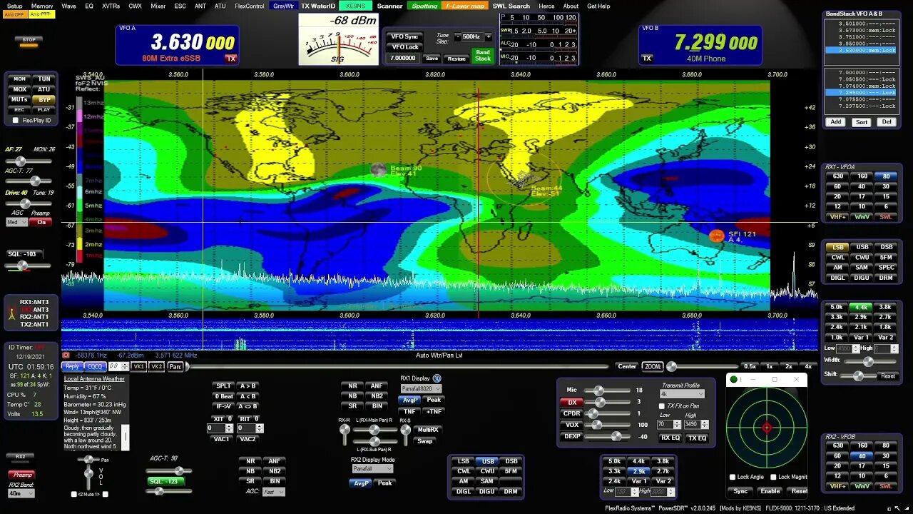
Maps of PowerSDR ke9ns v2.8
0:00 - Hold you mouse over the PowerSDR console "Maps" menu item and hit F1 to get a help window:
LEFT CLICK: SPOTTER TRACKING WORLD Map with Grayline, Sun-Moon Tracking, ISS, DX Spots, VOACAP
WHEEL CLICK: Opens separate Callsign prefix Map window
RIGHT CLICK: Toggles F-Layer, D-Layer, Lightning, Cloud cover Maps ON/OFF (Described below)
----------------------------------------------------------
0:44 - SPOTTER MAP provided by NOAA (see SPOTTER screen)
Shows World map with (SHIFT key) LAT/LONG, Day indicator, and optional Grayline, Sun, Moon, ISS
Shows Clickable (RED) spots directly on map (CTRL key goes directly to Spot Frequency)
Grid lines represent Lat, Long and +/- hours from UTC
VOACAP feature
----------------------------------------------------------
2:11 - F-LAYER MAP provided by: Australian gov space weather service critical foF2-Layer world map. (Updated every 30min)
Colors denoting the highest frequency the f2 ionosphere will reflect vertical directed signals directly back towards earth (NVIS)
Determined using ionosonde radar. The higher the reflect frequencies, the more open propagation will be in those areas.
If your station is under a Blue (or better) area on the F2 map,
you may experience skip conditions on or close to 10m to other Blue (or better) areas of the F2 map.
Red up to Blue usually indicates that the uppers bands are closed.
----------------------------------------------------------
3:28- D-LAYER MAP provided by: NOAA XRAY D-Layer Absorption level world map.
Absorbs Low Band RF in the D-Layer during daylight hours (and X-Ray events)
Higher frequencies can pass through the D-Layer up to the E/F-Layers unless shown on this map.
If you see a Space Weather report of "Radio Blackout", check for D-Layer absorption
----------------------------------------------------------
4:13 - LIGHTNING MAP provided by: Blitzortung
Real-Time but updated every 30 min
White = Recent Lighting strike (within 20 min)
Yellow = (within 40min)
Red = Very Old (within 120min)
HOLD CTRL+Z to Zoom or Magnify an area next to the Mouse on the Map.
----------------------------------------------------------
4:48 - CLOUD COVER MAP (Mosaic) Provided by: University of Wisconsin-Madison
Real-Time but updated every 30 min
Mosaic IR Cloud cover for most of the Earth
Note: No cloud data for lower center section of world map.
HOLD CTRL+Z to Zoom or Magnify an area next to the Mouse on the Map.
Download from my website at: ke9ns.com/flexpage.html
Darrin
ke9ns
-
 10:04
10:04
Space Ice
2 hours agoThe Movie Silent Hill Is Like Resident Evil Without The Good Parts - Worst Movie Ever
14.1K4 -
 5:49
5:49
Hannah Barron
23 hours agoRedneck Euro Mount
12.8K19 -
 32:34
32:34
hickok45
7 hours agoSunday Shoot-a-Round # 268
3.56K8 -
 27:33
27:33
The Finance Hub
17 hours ago $1.98 earnedBREAKING: ALINA HABBA JUST DROPPED A MASSIVE BOMBSHELL!!!
28.6K54 -
 40:23
40:23
PMG
21 hours ago $0.18 earnedHannah Faulkner and Dr. Michael Schwartz | EXPOSING BIG PHARMA
16.2K1 -
 18:55
18:55
GBGunsRumble
19 hours agoGBGuns Range Report & Channel Update 15FEB25
11.5K -
 13:31:32
iViperKing
20 hours agoGood Times + Good Energy Ft. Whez.. #VKGFAM #RRR
99.2K13 -
 12:24
12:24
Winston Marshall
1 day agoWOAH! Bannon just Revealed THIS About MUSK - The Tech-Right vs MAGA Right Civil War Ramps Up
225K309 -
 7:33:46
Phyxicx
19 hours agoRaid & Rant with the FF14 Guild on Rumble! Halo Night just wrapped up! - Go Follow all these great guys please! - 2/15/2025
151K4 -
 10:42:19
Reolock
21 hours agoWoW Classic Hardcore (LVL 60) | RAID DAY | Rumble FIRST HC Raid
97.3K5