Maps of PowerSDR ke9ns v2.8
0:00 - Hold you mouse over the PowerSDR console "Maps" menu item and hit F1 to get a help window:
LEFT CLICK: SPOTTER TRACKING WORLD Map with Grayline, Sun-Moon Tracking, ISS, DX Spots, VOACAP
WHEEL CLICK: Opens separate Callsign prefix Map window
RIGHT CLICK: Toggles F-Layer, D-Layer, Lightning, Cloud cover Maps ON/OFF (Described below)
----------------------------------------------------------
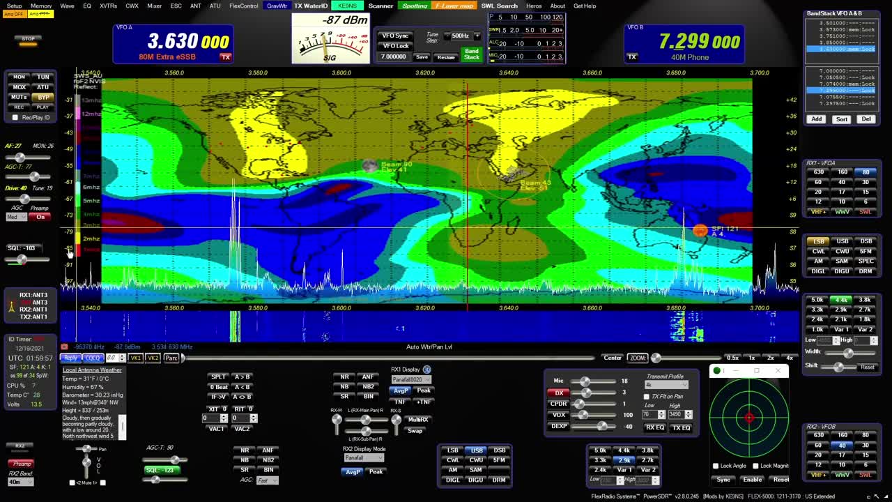
0:44 - SPOTTER MAP provided by NOAA (see SPOTTER screen)
Shows World map with (SHIFT key) LAT/LONG, Day indicator, and optional Grayline, Sun, Moon, ISS
Shows Clickable (RED) spots directly on map (CTRL key goes directly to Spot Frequency)
Grid lines represent Lat, Long and +/- hours from UTC
VOACAP feature
----------------------------------------------------------
2:11 - F-LAYER MAP provided by: Australian gov space weather service critical foF2-Layer world map. (Updated every 30min)
Colors denoting the highest frequency the f2 ionosphere will reflect vertical directed signals directly back towards earth (NVIS)
Determined using ionosonde radar. The higher the reflect frequencies, the more open propagation will be in those areas.
If your station is under a Blue (or better) area on the F2 map,
you may experience skip conditions on or close to 10m to other Blue (or better) areas of the F2 map.
Red up to Blue usually indicates that the uppers bands are closed.
----------------------------------------------------------
3:28- D-LAYER MAP provided by: NOAA XRAY D-Layer Absorption level world map.
Absorbs Low Band RF in the D-Layer during daylight hours (and X-Ray events)
Higher frequencies can pass through the D-Layer up to the E/F-Layers unless shown on this map.
If you see a Space Weather report of "Radio Blackout", check for D-Layer absorption
----------------------------------------------------------
4:13 - LIGHTNING MAP provided by: Blitzortung
Real-Time but updated every 30 min
White = Recent Lighting strike (within 20 min)
Yellow = (within 40min)
Red = Very Old (within 120min)
HOLD CTRL+Z to Zoom or Magnify an area next to the Mouse on the Map.
----------------------------------------------------------
4:48 - CLOUD COVER MAP (Mosaic) Provided by: University of Wisconsin-Madison
Real-Time but updated every 30 min
Mosaic IR Cloud cover for most of the Earth
Note: No cloud data for lower center section of world map.
HOLD CTRL+Z to Zoom or Magnify an area next to the Mouse on the Map.
Download from my website at: ke9ns.com/flexpage.html
Darrin
ke9ns
-
 LIVE
LIVE
Dr Disrespect
5 hours ago🔴LIVE - DR DISRESPECT - TRIPLE THREAT CHALLENGE - WZ, PUBG, FORTNITE
4,431 watching -
 2:12:54
The Quartering
4 hours agoAdam Schiff IN TROUBLE, Woke Lefties MELTDOWN Over Temu, Karmelo Anthony Family LIES, & Much More
103K33 -
 1:12:00
RiftTV/Slightly Offensive
2 hours ago $3.46 earnedWho KILLED Virginia Giuffre? Only 11% of Black Chicago Students Can READ? | The Rift Report
17.7K19 -
 LIVE
LIVE
The HotSeat
1 hour agoDeporting Illegals, Arresting Judges, and Saving Women's Sports — More, Please!
652 watching -
 25:18
25:18
Scary Mysteries
3 hours agoSTRANGE & SCARY Mysteries Of The Month - April 2025
6.85K4 -
 1:35:24
Russell Brand
5 hours agoEpstein’s Most Famous Accuser Found DEAD—Was She Silenced? – SF573
144K35 -
 1:49:00
Tucker Carlson
5 hours agoCatherine Fitts: Bankers vs. the West, Secret Underground Bases, and the Oncoming Extinction Event
108K99 -
 1:27:37
Sean Unpaved
4 hours agoPlayoff Fever, Draft Drama, MLB Thrillers & Belichick's Plus-One
42.9K3 -
 1:04:08
Jeff Ahern
2 hours ago $0.86 earnedMonday Madness with Jeff Ahern (12pm Pacific)
12.8K2 -
 59:34
59:34
The White House
5 hours agoPress Secretary Karoline Leavitt Briefs Members of the New Media, Apr. 28, 2025
51.7K32