Premium Only Content
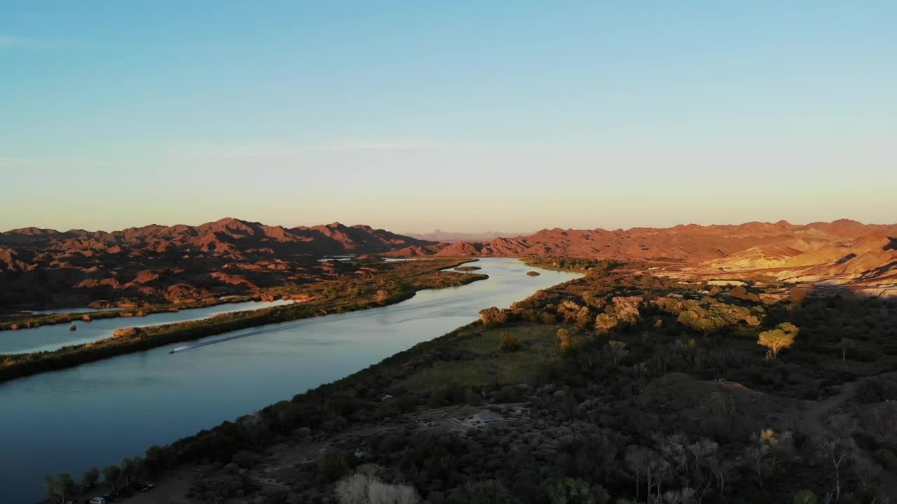
Aerial Views Over The Colorado River Near Picacho Reacreation Area
Aerial views from the drone over Picacho State Recreation Area. It is a camping, boating, and general recreation area located on a 9-mile stretch of the Lower Colorado River at the site of Picacho, a defunct gold mining town.
This remote park is located in the far southeastern corner of California and includes 54 campsites, 3 boat launches, and 5 river camps. Favorite activities at the park include stargazing, and bird and wildlife viewing (including the famous desert resident, the Bighorn sheep).
The mining town of Picacho sat on this spot in the early 1900s. The remains of a stamp mill that was used to crush the gold ore during mining operations is a popular hiking destination.
This section of the Colorado River is a popular stopover for migratory waterfowl - ducks, geese, ibis, and cormorants - usually seen by the thousands in spring and fall. Other waterfowl are found here year-round.
Location-Directions
Take the 24-mile (mostly unpaved) road north from Winterhaven near the Mexican border. The road to Picacho from Winterhaven is paved only for the first 6 of 24 miles. The last 18 miles is over a dirt road that is passable for cars and vehicles with trailers and motorhomes. At times during the summer, thunderstorms are likely to cause flash flooding in the washes, temporarily making short sections of the road impassable.
-
 0:28
0:28
Tiggertoo007
3 years ago $0.01 earnedBase jump Colorado river
49 -
 0:13
0:13
Nature
4 years agoaerial view over the city near river winter 7
81 -
 0:47
0:47
The Adventures Of Life With My Queen
3 years agoColorado River Kayaking
42 -
 4:45
4:45
KNXV
3 years agoArizona counties, towns battle over Colorado River water rights
24 -
 0:31
0:31
Outdoor Adventures
3 years agoBeautiful river in Silverton Colorado.
642 -
 4:10
4:10
ER's Adventures
3 years ago $0.04 earnedTelephone Cove - Nevada , Colorado River
159 -
 0:29
0:29
KNXV
3 years agoWoman missing after drowning incident in Colorado River
1.24K -
 LIVE
LIVE
Steven Crowder
1 hour ago🔴 What We've Missed | A Pop Culture Catch-Up
34,433 watching -
 LIVE
LIVE
Tim Pool
1 hour agoAmerica's Obesity & Health Crisis, MAKE AMERICA HEALTHY AGAIN | The Culture War with Tim Pool
4,553 watching -
 LIVE
LIVE
Benny Johnson
31 minutes ago🚨Trump SHOCK Announcement LIVE Right Now | Trump Assassination Report Release, Assassin in Court
11,938 watching