Every Earthquake | Timelapse: 1900 - 2021 | Earthquake Map 🌊📊
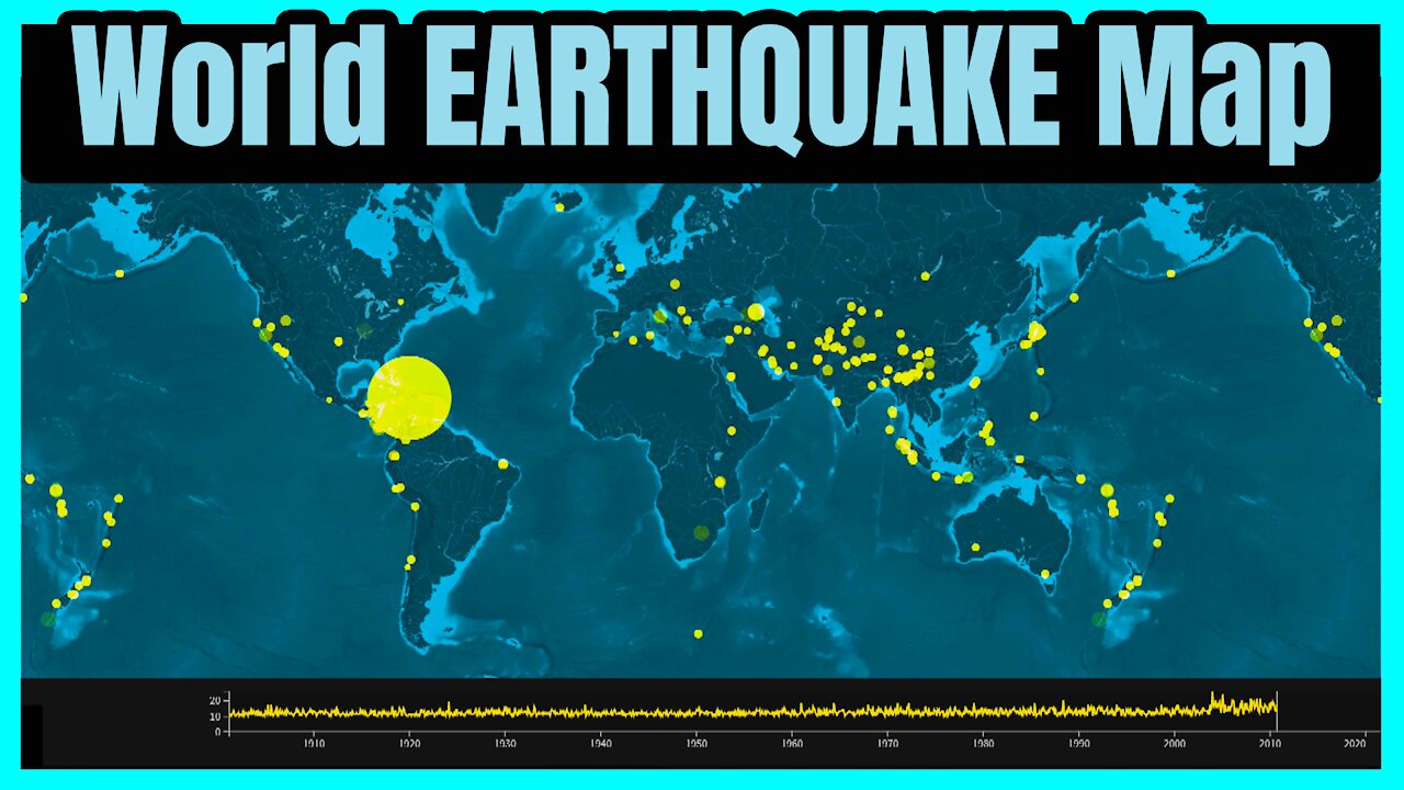
This data visual and animated map tracks significant (*) earthquakes across the world from 1900 - 2021. The size and scale of the dots are determined by the estimated death toll. The graph at the bottom tracks the number of (significant) earthquakes on a monthly basis.
Chapters:
00:00 Largest earthquake ever recorded: 9.5 magnitude in Chile
00:29 San Francisco moving toward Los Angeles; San Andreas fault
00:52 There are about 500,000 earthquakes per year
01:16 The sun and moon cause tremors
01:39 In Japanese mythology it was believe that Namazu, a giant catfish, caused earthquakes
02:02 Oil extraction can cause minor earthquakes
02:26 An earthquake can affect the length of a day
02:49 Standing water smells before an earthquakes
03:13 What is an earthquake seiche?
03:36 Earthquake footage
(*) The Significant Earthquake Database contains information on destructive earthquakes from 2150 B.C. to the present that meet at least one of the following criteria: Moderate damage (approximately $1 million or more), 10 or more deaths, Magnitude 7.5 or greater, Modified Mercalli Intensity X or greater, or the earthquake generated a tsunami.
Earthquakes can also generate sizeable tsunamis as was the case in the following:
8.8 magnitude earthquake: Ecuador-Columbia — 31 January 1906
8.5 magnitude earthquake: Atacama, Chile — 11 November 1922
8.4 magnitude earthquake: Kamchatka, Russia — 3 February 1923
8.4 magnitude earthquake: Sanriku, Japan — 2 March 1933
8.6 magnitude earthquake: Unimak Island, Aleutian Islands — 1 April 1946
9.0 magnitude earthquake: Kamchatka, Russia — 4 November 1952
8.6 magnitude earthquake: Andreanof Islands, Aleutian Islands — 9 March 1957
9.5 magnitude earthquake: Valdivia, Chile — 22 May 1960
9.2 magnitude earthquake: Prince William Sound, Alaska — 28 March 1964
8.7 magnitude earthquake: Rat Islands, Aleutian Islands — 4 February 1965
7.7 magnitude earthquake: Kalapana, Hawaii — 29 November 1975
8.4 magnitude earthquake: Southern Peru — 23 June 2001
9.1 magnitude earthquake: Sumatra, Indonesia — 26 December 2004
8.1 magnitude earthquake: Samoan Islands — 29 September 2009
8.8 magnitude earthquake: Maule, Chile — 27 February 2010
9.0 magnitude earthquake: Tohoku, Japan — 11 March 2011
7.9 magnitude earthquake: Haida Gwaii, Canada — 28 October 2012
Don't forget to like, share, and comment! Subscribe for several weekly uploads! 🙏 📊
📊 Data:
National Geophysical Data Center / World Data Service (NGDC/WDS): NCEI/WDS Global Significant Earthquake Database. NOAA National Centers for Environmental Information. doi:10.7289/V5TD9V7K
📰Publications:
https://www.bbc.co.uk/programmes/articles/1SlLY6lpq5vgxXNXfVlJSvq/12-surprising-facts-about-earthquakes
https://www.livescience.com/6187-13-crazy-earthquake-facts.html
https://www.guinnessworldrecords.com/world-records/66811-most-powerful-earthquake
https://www.britannica.com/science/earthquake-geology
🎵 Track Info:
https://www.youtube.com/watch?v=fzz9JutOt38
https://www.youtube.com/watch?v=XnYh2ZaiLdE
#Earthquakes #Maps #AnimatedMaps #DataVisualization #MapVisuals #AnimatedStats #Haiti
-
 4:08
4:08
Data Ninja
3 years agoWorld's Most Visited Websites | Website Wars 🌐📊
1771 -
 DVR
DVR
EricJohnPizzaArtist
4 hours agoAwesome Sauce PIZZA ART LIVE Ep. #37: Chaos in Roswell!
26.7K2 -
 2:11:29
vivafrei
14 hours agoEp. 253: Zelensky Dress-Down and Geopolitical Fallout! D.C. Court Rules AGAINST Trump Firing & MORE!
155K263 -
 2:13:14
Nerdrotic
7 hours ago $7.76 earnedMegalithomania! with Hugh Newman and Andrew Collins | Forbidden Frontier #092
65.6K19 -
 38:41
38:41
Sarah Westall
9 hours agoHealth Freedom Under Attack, Dr Robert Young Found Guilty on Suspicious Victimless Crime, Matt Hazen
63.5K6 -
 LIVE
LIVE
Vigilant News Network
8 hours agoDataRepublican Exposes the Shadow Government’s Darkest Secrets - Exclusive Interview | Media Blackout
1,833 watching -
 31:39
31:39
Peter Santenello
1 year agoStories From Vegas' Golden Era 🇺🇸
61.6K25 -
 LIVE
LIVE
The Why Files
12 hours agoLIVE: The Why Files 24/7 Stream n' Chat
1,308 watching -
 55:15
55:15
Russell Brand
1 day agoThe Truth About Big Pharma & COVID with Dr. Aseem Malhotra
174K11 -
 1:19:48
The Rubin Report
12 hours agoWhat the Trump Administration Must Do Instead of Revenge | Peter Thiel
131K168