Premium Only Content

Mapping the Topography of the Ocean Floor; Underwater Volcanoes, Mountains and Valleys
5.1 Mapping the Topography of the Ocean Floor; Underwater Volcanoes, Mountains and Valleys
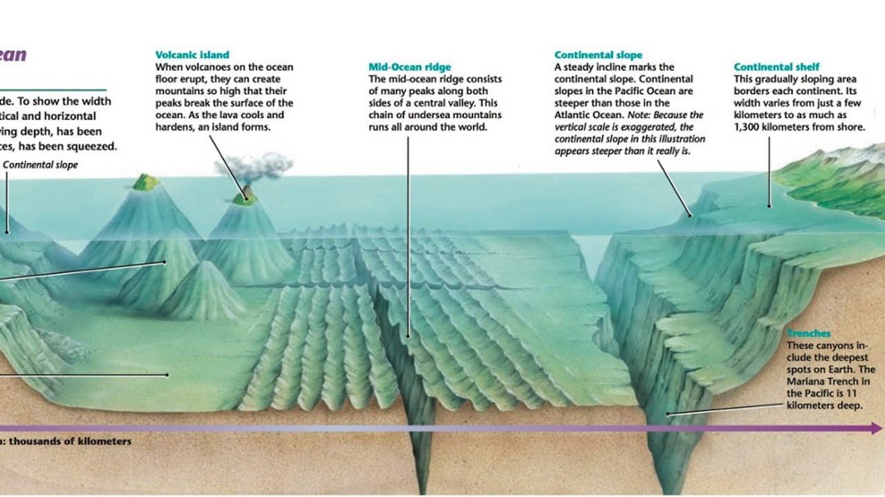
The ocean is the largest feature on Earth, covering more than 70% of our planet's surface. One of the main reasons that Wegener's continental drift hypothesis was not widely accepted when first proposed was that so little was known about the ocean floor. Until the 20th century, investigators used weighted lines to measure water depth. In deep water these depth measurements, or soundings, took hours to perform and could be wildly inaccurate.
With the development of new marine tools following World War II, our knowledge of the diverse topography of the ocean floor grew rapidly. One of the most interesting discoveries was the global oceanic ridge system. This broad elevated landform which stands two to three kilometers above the adjacent deep ocean basins, is the longest topographic feature on Earth.
Today we know that oceanic ridges mark divergent plate margins, where new oceanic lithosphere originates. We also know that deep ocean trenches represent convergent plate boundaries, where oceanic lithosphere is subducted into the mantle. Because the process of plate tectonics is creating oceanic crust at mid-ocean ridges and consuming it at subduction zones, the oceanic crust is continually being renewed and recycled.
-
 0:13
0:13
tarunrr
3 years agoUnderwater Ocean Footage
35 -
 0:45
0:45
Amazing Ocean
3 years agoBeautiful underwater dwellers | Amazing Ocean Discoveries
118 -
 24:09
24:09
Squaring The Circle, A Randall Carlson Podcast
2 hours ago#033 At The Crossroads - Squaring the Circle: A Randall Carlson Podcast
6851 -
 50:17
50:17
BIG NEM
4 days agoBrian Herzog: From Zero to 150 MILLION Views in a Year 🚀
798 -
 2:48:35
FreshandFit
15 hours agoHenny Chris VIOLATES 5 Girls 🤣
175K138 -
 6:33:57
AdmiralSmoothrod
16 hours agoescape from tarkov - the best and brightest - party games later?
131K12 -
 59:15
59:15
RealitySurvival
18 hours agoMore in coming Chaos? War With China? Trumo Tower Bombing & Bourbon Street Massacre
844 -
![VOYAGER - Brightstar [Official Music Video]](https://1a-1791.com/video/fw/s8/1/X/N/Y/l/XNYlv.0kob-small-VOYAGER-Brightstar-Official.jpg) 4:34
4:34
SeasonofMist
1 month agoVOYAGER - Brightstar [Official Music Video]
4881 -
 10:00
10:00
Ethical Preparedness
3 hours ago $0.88 earnedWhat Everybody is Missing About the Recent Terror Attacks in the USA
1.17K9 -
 24:21
24:21
CutJibNewsletter
1 day agoHappy New Year, Same Old Terrorism Episode
5481