NBC26 Storm Shield weather forecast
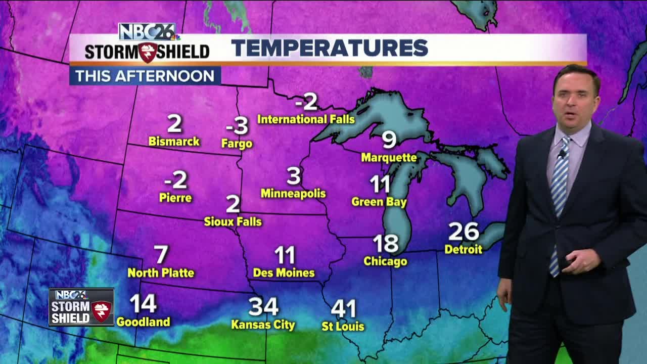
Monday was the coldest day since January & now more snow is on the way!! Tonight, we'll have some cloudiness, but those winds will be dying down a little. It's going to be very cold for this time of year with lows in the mid-single digits below zero. Tuesday, most of the daytime should be okay with the exception of the late afternoon when we could see a few flurries or light snow, but the more significant snow will get here on Tuesday evening. Highs Tuesday will only be in the mid-teens. Tuesday night into Wednesday our next snow-maker will be moving through. This will cause some headaches for the Wednesday morning commute especially. Accumulations at this time look to be between 4-7". Luckily, it won't be as windy as this past weekend's storm. Lows will be in the low-teens. Cold weather will persist on Thursday with the chance of some light snow & flurries. Chances of snow start to increase, especially Friday night into Saturday where more snow accumulation will be possible. FRIGID air moves back in this weekend. If you want spring weather on March 1st, good luck finding that in Northeast Wisconsin. At this rate, perhaps staying in Florida for the time being might be a safer bet.
-
 0:30
0:30
WGBA
1 year agoThree Degree Guarantee
262 -
 2:54
2:54
WGBA
3 years agoGino Recchia NBC26 Weather Forecast
3 -
 2:41
2:41
WGBA
3 years agoGino Recchia NBC26 Weather Forecast
2 -
 3:33
3:33
WGBA
3 years agoGino Recchia NBC26 Weather Forecast
6 -
 3:07
3:07
WGBA
3 years agoGino Recchia NBC26 Weather Forecast
3 -
 3:58
3:58
WGBA
3 years agoGino Recchia NBC26 Weather Forecast
5 -
 2:56
2:56
WGBA
3 years agoGino Recchia NBC26 Weather Forecast
5 -
 4:13
4:13
WGBA
3 years agoGino Recchia NBC26 Weather Forecast
31 -
 4:13
4:13
WGBA
3 years agoGino Recchia NBC26 Weather Forecast
41 -
 2:53
2:53
WGBA
3 years agoGino Recchia NBC26 Weather Forecast
2