🚨 March 4-5: Severe Supercells & Tornado Risks Loom!
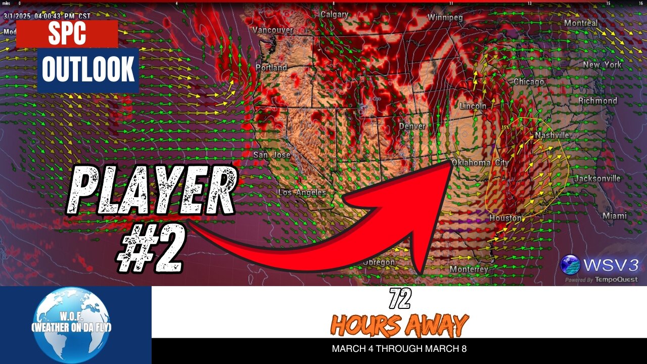
Brace yourself! 🚨 March 4-5, 2025, brings the potential for severe supercells and tornado risks across the Lower Mississippi Valley and beyond. Our latest medium-range forecast highlights strong cyclogenesis, intense wind shear, and a high chance of damaging straight-line winds, all contributing to a volatile weather setup. W.O.F. (Weather On da Fly) is your #1 source for quick Severe/Tropical Weather Outlooks & Discussions, breaking down everything you need to know about this potentially dangerous system. Stay ahead of the storm with accurate updates on SPC guidance, NOAA data, and evolving storm threats.
While uncertainties remain about some details, the environment on March 4-5 could trigger organized supercells and tornadoes, especially as Gulf moisture surges into the region. From the Lower Mississippi Valley to the Southern Atlantic Seaboard, severe weather may impact millions, so preparation is key. Don't miss your chance to stay informed with W.O.F.!
Hit that #Like button, #Share this critical update, and #Subscribe to W.O.F. (Weather On da Fly) for ongoing insights during March 2025. Stay safe, stay prepared, and count on us for all your weather updates! 🌪️☔🌩️
#weatherupdatetoday #clevelandweatherupdatetoday #clevelandweathernews #clevelandweather #clevelandweatherforecast
CHAPTERS:
00:00 - SPC Outlook
00:14 - Severe Weather Threat Analysis
02:18 - Like, Share, & Subscribe
-
 DVR
DVR
Alex Zedra
4 hours agoLIVE! Playing Call of Duty :D
56.2K6 -
 5:45:36
Film Threat
1 day agoLIVE OSCARS 2025 WATCH PARTY | 97th Academy Awards | Join the Chat!
69.1K7 -

Akademiks
6 hours agoDay 2/30. Nipsey Hussle Brother Standing on Bizniz? Offset and Cardi Calls it Quits. 50 v Jim Jones?
83.4K5 -
 5:24:38
EricJohnPizzaArtist
6 hours agoAwesome Sauce PIZZA ART LIVE Ep. #37: Chaos in Roswell!
40.4K3 -
 2:11:29
vivafrei
16 hours agoEp. 253: Zelensky Dress-Down and Geopolitical Fallout! D.C. Court Rules AGAINST Trump Firing & MORE!
179K287 -
 2:13:14
Nerdrotic
9 hours ago $9.37 earnedMegalithomania! with Hugh Newman and Andrew Collins | Forbidden Frontier #092
78.2K13 -
 38:41
38:41
Sarah Westall
11 hours agoHealth Freedom Under Attack, Dr Robert Young Found Guilty on Suspicious Victimless Crime, Matt Hazen
80K9 -
 LIVE
LIVE
Vigilant News Network
10 hours agoDataRepublican Exposes the Shadow Government’s Darkest Secrets - Exclusive Interview | Media Blackout
2,029 watching -
 31:39
31:39
Peter Santenello
1 year agoStories From Vegas' Golden Era 🇺🇸
77.1K25 -
 LIVE
LIVE
The Why Files
13 hours agoLIVE: The Why Files 24/7 Stream n' Chat
1,411 watching