
NBC26 Storm Shield Weather Forecast
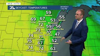
Today we are back in the upper-60s to low-70s to kick off the work week. Winds will be a bit breezy out of the southeast between 5 to 15 mph keeping it just a little cooler near Lake Michigan. Skies should range from sunny to partly cloudy as the day wears on. There could be an isolated rain shower tonight ahead of an approaching cold front from a low pressure system. Lows tonight will be in the upper-50s. A cold front will be sweeping through bringing scattered showers and T'storms. Most of the activity will be in the afternoon. Highs will continue to be mild with afternoon readings in the low-70s. Any lingering evening shower or T'storm will exit the area to the southeast as that front exits. It'll be a with lows in the upper-40s, which is actually close to normal for this time of year. This cooler air will stick around for the extended period with highs Wednesday and Thursday in the low-60s, and upper-50s for Friday and Saturday. Let's see who can make it through the upcoming weekend without kicking the furnace on.
-
 1:57
1:57
WGBA
1 year agoHow the City of Green Bay is hoping a $1.6M investment will make the community safer for pedestrians
3251 -
 3:52
3:52
WGBA
3 years agoGino Recchia NBC26 Weather Forecast
10 -
 3:34
3:34
WGBA
3 years agoGino Recchia NBC26 Weather Forecast
11 -
 4:01
4:01
WGBA
3 years agoGino Recchia NBC26 Weather Forecast
15 -
 3:11
3:11
WGBA
3 years agoGino Recchia NBC26 Weather Forecast
5 -
 3:33
3:33
WGBA
3 years agoGino Recchia NBC26 Weather Forecast
4 -
 3:45
3:45
WGBA
3 years agoGino Recchia NBC26 Weather Forecast
1 -
 4:02
4:02
WGBA
3 years agoGino Recchia NBC26 Weather Forecast
8 -
 3:46
3:46
WGBA
3 years agoGino Recchia NBC26 Weather Forecast
6 -
 3:46
3:46
WGBA
3 years agoGino Recchia NBC26 Weather Forecast
15