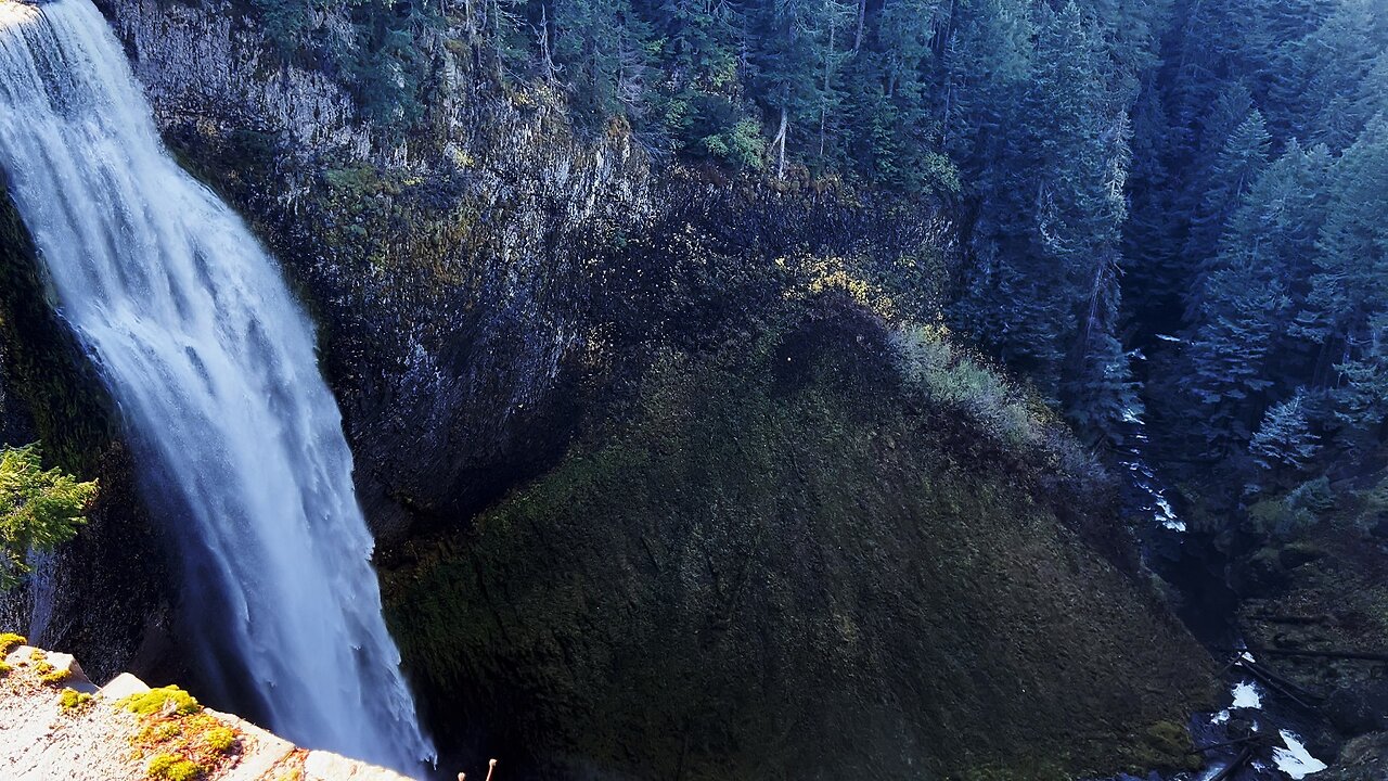
SILENT PERSPECTIVES (4K) of Salt Creek Falls, 2nd Tallest Waterfall in Oregon! | Upper Middle Lower
Silent Perspectives Montage of 8 Unique 4K Clips of Lower, Middle & Upper Viewpoints of Salt Creek Falls, each Clips is original, no Clip appears twice.
This was a Day-Hike (November 6, 2024) in the Willamette Pass area of Central Oregon, Willamette National Forest, Hiking Salt Creek Falls Trail. The Salt Creek Falls Observation Site & Picnic Area is a National Fee Area, NW Forest Pass accepted. The Area is divided into two distinct Hikes - the easier one to the Right is Salt Creek Falls Trail to Upper, Middle & Lower Viewpoints, approximately 0.6 Miles and around 200 FT Elevation Gain. *That Short Hike Only is This Video!* You can also go to the Left and do the Diamond Creek Falls Loop, including Shoreline Access to Too Much Bear Lake, which is a 3.2 Mile, 500+ FT Elevation Gain Loop on it's own. The BEST WAY to Hike this Area is to combine both Waterfall Hikes into a Super Loop and see it all in one go, which is still a relatively modest Hike of around 3.9 Miles and 750 FT Elevation Gain.
In Conclusion, there are three ways to Hike/Explore/Tackle this area:
1) Salt Creek Falls Trail ONLY - EASIEST OPTION - 0.6 Miles, 200+ FT Elevation Gain *THIS FULL HIKE IS CAPTURED IN THIS VIDEO!*
2) Diamond Creek Falls Loop & Too Much Bear Lake ONLY - MODERATE OPTION - 3.2 Miles, 500+ FT Elevation Gain
3) THE BEST WAY - One Super Loop Combining ALL Highlights - Salt Creek Falls, Diamond Creek Falls Loop & Too Much Bear Lake - HARDEST OPTION - 3.9 Miles, 750 FT Elevation Gain - *Please Note these Hiking Stats are still relatively modest in the grander scheme of Adventure Hiking, keeping it real.*
Lastly, there is another option to Hike South to Vivian Lake, but that is more of a Forest Hike away from this infrastructure that just happens to share the Parking Trailhead, so I won't go into detail on that Hike here.
Here is the VIDEO Exploring the nearby Princess Creek Campground Boat Ramp Launch @ Odell Lake:
Here is the FULL HIKE VIDEO Exploring the Shoreline of nearby Crescent Lake in the Campground Zone:
Here is the VIDEO Hiking the Simax Beach Shoreline of nearby Crescent Lake:
-
 25:28
25:28
HikingViking
20 days ago3 LARGE GROUP CAMPSITES @ Haystack Reservoir (East) Campground | Crooked River National Grassland 4K
1202 -
 2:06:17
Glenn Greenwald
3 hours agoJudge Orders Hearing on Columbia Student Deportation Case; Is the Ukraine Ceasefire Plan Serious? Trump Attacks Thomas Massie for His Budget Vote | SYSTEM UPDATE #422
67.4K51 -
 47:16
47:16
BonginoReport
6 hours agoTrump-Elon Bromance Triggers The Libs (Ep.03) - 03/12/2025
102K179 -
 4:03:41
Barry Cunningham
7 hours agoTRUMP DAILY BRIEFING: PRESIDENT TRUMP PRESS CONFERENCE | DEMOCRATS IN PANIC!
59.3K49 -
 1:56:30
Melonie Mac
4 hours agoGo Boom Live Ep 40!
21K2 -
 DVR
DVR
Kim Iversen
4 hours agoDOGE, Trump, Aliens and Remote Viewing: A Deep Dive into the Unknown
24K23 -
 1:20:08
Redacted News
6 hours agoPutin smells a TRAP as Ukraine agrees to Trump's U.S. ceasefire plan | Redacted w Clayton Morris
145K155 -
 51:59
51:59
Candace Show Podcast
6 hours agoMahmoud Khalil’s Detainment: Fighting Terrorism Or Speech? | Candace Ep 158
104K310 -
 7:43:31
Dr Disrespect
10 hours ago🔴LIVE - DR DISRESPECT - PUBG - PRO TACTICALLY WINNING
162K15 -
 1:02:40
In The Litter Box w/ Jewels & Catturd
1 day agoUSAID to Staff: Shred and Burn | In the Litter Box w/ Jewels & Catturd – Ep. 760 – 3/12/2025
85.4K32