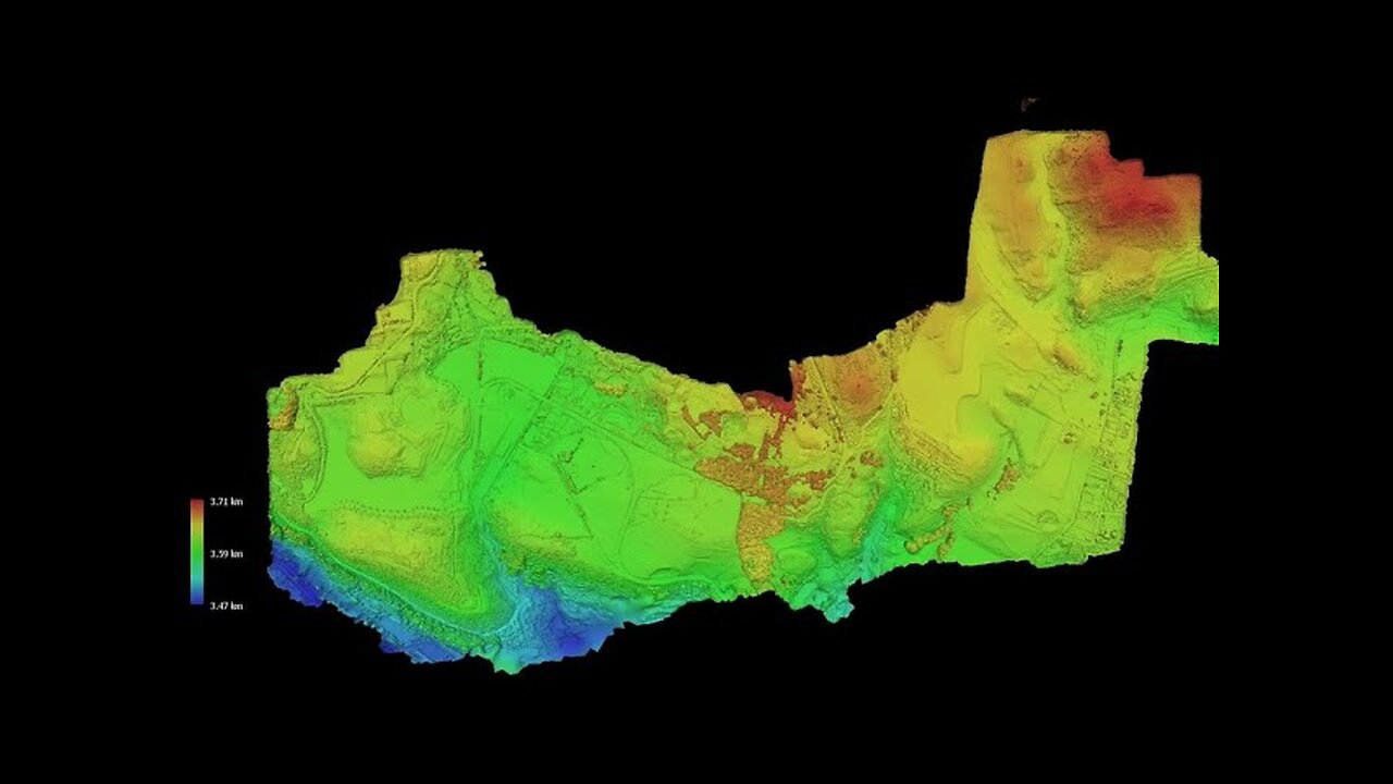
Photogrammetric 3D model of the Greater Sacsayhuaman Area
3 months ago
6
This impressive 3D model made up of more than 64 million polygons and covering an area of 2.2 square km, was created by photogrammetry wizard Marián Marčiš, combining about 2500 drone photos and 350 ground photos.
To see more of his work, you can follow him on X (https://www.x.com/mariusderomanu3) and check his publications on ResearchGate (https://www.researchgate.net/profile/Marian-Marcis-2)
_______________________________________________________________________
Music track: ReminiscenceLicense: Creative Commons (CC BY 3.0) https://creativecommons.org/licenses/by/3.0
https://www.youtube.com/user/ThisIsTheFatRatMusic powered by BreakingCopyright: https://breakingcopyright.com
Loading comments...
-
![🔴[LIVE TRADING] Markets Finally Push Higher!!! || The MK Show](https://1a-1791.com/video/fww1/05/s8/1/1/C/3/E/1C3Ey.0kob-small-The-MK-Show-Apr.-25th.jpg) LIVE
LIVE
Matt Kohrs
9 hours ago🔴[LIVE TRADING] Markets Finally Push Higher!!! || The MK Show
17,264 watching -
 LIVE
LIVE
Badlands Media
7 hours agoBadlands Daily: April 25, 2025
3,868 watching -
 LIVE
LIVE
Randi Hipper
28 minutes agoRANDI HIPPER 5 YEAR ANNIVERSARY CELEBRATION! BITCOIN NEWS
324 watching -
 LIVE
LIVE
Wendy Bell Radio
5 hours agoSmells Like Dem Panic
9,357 watching -
 LIVE
LIVE
LFA TV
13 hours agoALL DAY LIVE STREAM - 4/25/25
10,220 watching -
 1:31:32
BEK TV
9 hours agoThe Truth About Autism, Vaccines, and Parasites They Don’t Want You to Know - Dr. Jason Dean
3.04K -
 25:12
25:12
JasminLaine
19 hours agoMark Carney Gets GRILLED By Reporter—Lies Finally Get Fact-Checked… PUBLICLY
18K36 -
 11:46
11:46
Tactical Considerations
16 hours ago $4.80 earnedKimber CDS9 The Micro 1911 That Seems To Have It All
25.7K5 -
 15:48
15:48
IsaacButterfield
1 day ago $3.45 earnedWoke Lunatic ATTACKS My 2 Year Old Son!!
31.2K33 -
 55:00
55:00
The Hannah Faulkner Show
23 hours ago $2.55 earnedKLAUS SCHWAB RESIGNS & A NEW POPE with Mike Crispi | The Hannah Faulkner Show
30.1K9