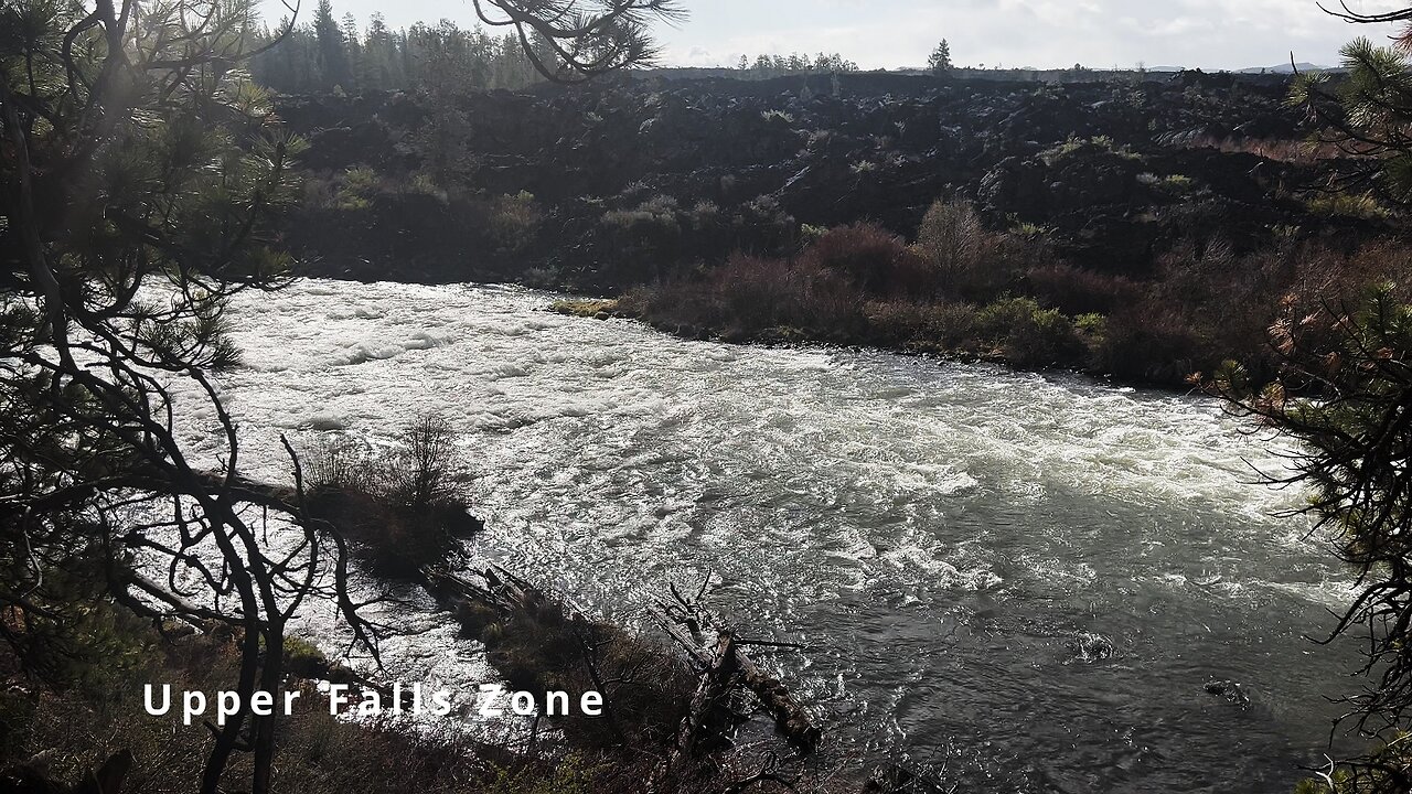
HIKING EXPLORING the Deschutes River Upper Falls Zone IN THE POURING RAIN! | Central Oregon | 4K
Chapters & Timestamps:
0:00 Arriving at the Edge of the EPIC Upper Falls Zone IN THE POURING RAIN!
0:24 Hiking Above the Upper Falls Area, a River Forest Volcanic Lava Rock Wonderland!
0:54 "Silent Perspectives" 4K Montage of 7 Unique Clips of Upper Falls & National Wild & Scenic Upper Deschutes River framed by Deschutes National Forest
In my opinion, there are about 8 Miles of PREMIUM River Shoreline Hiking on Deschutes River Trail along National Wild & Scenic Upper Deschutes River, Deschutes National Forest, Central Oregon.
This is EASILY a TOP 5 River Shoreline Hike in the Great State of Oregon! There are 3 Strategic Approaches to Capture/Tackle this EPIC area:
1) 8 Mile Point-to-Point Hike from Meadow Day Use Area to Sun-Lava Path Trailhead (called East Benham Falls Trailhead on Google Maps), in either Direction, need to arrange transportation at end of Hike!
2) 16 Mile Out & Back Hike from Meadow Day Use Area to Dillon Falls to Benham Falls to Sun-Lava Path Trailhead (called East Benham Falls Trailhead on Google Maps), in either Direction, no transportation logistics required, the Superstar Hiker Method!
3) Break Deschutes River Trail up into 2 separate more leisurely 8-Miles'ish Out & Back Hikes using Dillon Falls as the Midpoint:
a) Meadow Day Use Area Trailhead to Dillon Falls & Back.
b) Sun-Lava Path Trailhead (called East Benham Falls Trailhead on Google Maps) to Dillon Falls & Back.
On April 22, 2022, I Hiked 8 Miles Point-to-Point from Sun-Lava Path Trailhead (called East Benham Falls Trailhead on Google Maps) heading North to Benham Falls, Slough Day Use Area, Dillon Falls, Aspen Day Use Area, Big Eddy, Upper Falls, Lava Island Day Use Area, Lava Island to Meadow Day Use Area. It was a Low of 29F. Here is the FULL HIKE Video Link of that Hike:
On May 6, 2022, I Hiked 8 Miles Point-to-Point from Meadow Day Use Area Trailhead heading South to Lava Island, Lava Island Day Use Area, Upper Falls, Big Eddy, Aspen Day Use Area, Dillon Falls, Slough Day Use Area & Benham Falls to Sun-Lava Path Trailhead (called East Benham Falls Trailhead on Google Maps). It was a Low of 33F. There was a freak Hail Storm that added to the experience:
-
 25:28
25:28
HikingViking
14 days ago3 LARGE GROUP CAMPSITES @ Haystack Reservoir (East) Campground | Crooked River National Grassland 4K
1082 -
 2:36:02
Slightly Offensive
9 hours ago $19.20 earnedCandace REDPILLS the Masses in BOMBSHELL Theo Von Interview | Guest: Shane Cashman
58.9K26 -
 2:29:20
DLDAfterDark
5 hours ago $5.68 earnedDLD Live! That Sh... Will Get You K***ed! What To Consider in SHTF
35.6K1 -
 2:15:08
megimu32
9 hours agoON THE SUBJECT: IRL Streamers Attacked & Nostalgic Animal Movies That Made Us Cry
61.8K5 -
 1:00:54
The Tom Renz Show
12 hours agoMore Epstein/FBI, a Scary Trade War, & the Dem Echo Chamber
51.2K11 -
 40:43
40:43
Kimberly Guilfoyle
13 hours agoDems Double Down on Delusion-Why? Live with Tony Kinnett & Bo French | Ep.202
132K44 -
 1:28:42
Redacted News
11 hours agoBREAKING! SOMETHING BIG IS HAPPENING IN EUROPE ALL OUT WAR IS COMING AGAINST RUSSIA, TRUMP FURIOUS
174K340 -
 47:50
47:50
Candace Show Podcast
12 hours agoBREAKING: Judge Makes Statement Regarding Taylor Swift's Text Messages. | Candace Ep 155
163K138 -
 1:14:23
Josh Pate's College Football Show
9 hours ago $2.94 earnedCFB’s Most Hated Teams | FSU & Clemson Future | Big Ten Win Totals | Star Rankings Overrated?
39.6K -
 1:33:47
CatfishedOnline
10 hours agoGoing Live With Robert - Weekly Recap
50K1