Premium Only Content

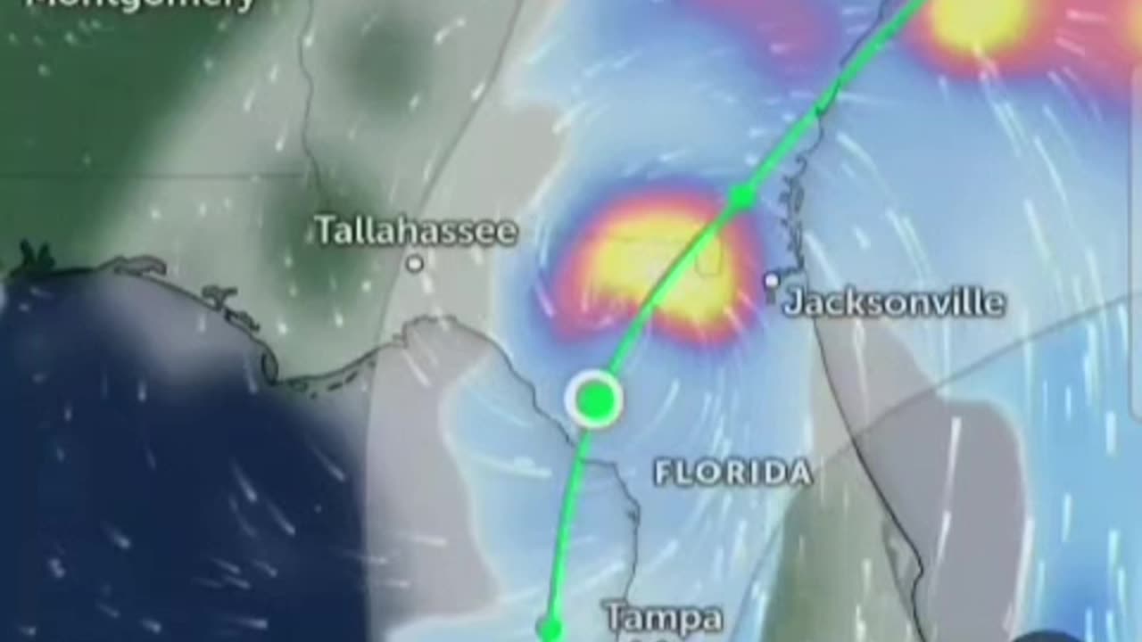
FLORIDA LANDFALL TROPICAL STORM, Carolinas viable HURRICANE DEBBIE cat2: 110mph
FLORIDA LANDFALL, TROPICAL STORM Carolinas viable HURRICANE DEBBIE : Cat2 110mph Active Systems:
The National Hurricane Center is issuing advisories on Potential
Tropical Cyclone Four, located over eastern Cuba.
* Formation chance through 48 hours...high...80 percent.
* Formation chance through 7 days...high...90 percent.
Tropical cyclone formation is not expected during the next 7 days.
&&
Public Advisories on Potential Tropical Cyclone Four are issued
under WMO header WTNT34 KNHC and under AWIPS header MIATCPAT4.
Forecast/Advisories on Potential Tropical Cyclone Four are issued
under WMO header WTNT24 KNHC and under AWIPS header MIATCMAT4.
$$
Forecaster Papin#Saturday Environmental conditions are expected to be #conducive for additional
development after that time, and a #tropical depression is likely to form this #weekend over the Straits of Florida or eastern #Gulf of
Mexico near the Florida Peninsula. #NorthCarolina #southcarolina
Tropical storm #watches or #warnings could be required for portions of Florida later today.
Active Systems:
The National Hurricane Center is issuing advisories on Potential
Tropical Cyclone Four, located over eastern Cuba.
* Formation chance through 48 hours...high...80 percent.
* Formation chance through 7 days...high...90 percent.
Tropical cyclone formation is not expected during the next 7 days.
&&
Public Advisories on Potential Tropical Cyclone Four are issued
under WMO header WTNT34 KNHC and under AWIPS header MIATCPAT4.
Forecast/Advisories on Potential Tropical Cyclone Four are issued
under WMO header WTNT24 KNHC and under AWIPS header MIATCMAT4.
$$
Forecaster Papin
Regardless of development, heavy rains could cause areas of flash #atlantic #atlanticocean
flooding across Florida, Cuba, and the Bahamas through the weekend,
and interests in these locations should continue to monitor the
progress of this system. A #NOAA Hurricane Hunter #aircraft is
scheduled to investigate this system later today.
* Formation chance through 48 hours...medium...60 percent.
* Formation chance through 7 days...high...90 percent.Southwestern Atlantic and Eastern #GulfofMexico:
A well-defined tropical wave is producing a large area of
disorganized showers and thunderstorms over #Hispaniola #PuertoRico the #VirginIslands and the adjacent waters of the
southwestern Atlantic and northeastern #Caribbean Sea. Development of
this system should be slow to occur during the next couple of days
while it moves west-northwestward over portions of the Greater
Antilles. However, environmental conditions are forecast to be more
conducive for development after the #tropicalwave passes the Greater
#Antilles and a tropical depression could form this weekend or early
next week over the eastern Gulf of Mexico or near the #FloridaPeninsula Interests across the Greater Antilles, the #Bahamas and
Florida should continue to monitor the progress of this system.
* Formation chance through 48 hours...low...20 percent.
* Formation chance through 7 days...medium...60 percent.
#Forecaster Beven
#Hurricane #Hurricanes #tropicalstorm #storms #tropicalwaves #thunderstorms #rainfall #rain #weather #flooding #forecast #TiffanysContent #heat #hot #Hurricaneseason #tropics #tropicalstorms #tropical #formation #hurricaneberyl #hurricanecarlotta #carlotta #Pacific ##gulfofmexico #tropicalcyclone #atlantic #tropicaldepression #epac #carlotta #Florida #tampa #miami #orlando #Jacksonville #crystaleiver #Puertorico #bahamas #cedarkey #floridapanhandle #hurricaneberyl #Beryl #winds #wind #florida #jacksonville #tropicalcyclone #forecast #severe #flooding #storms #rain #flooding #Mexico #cuba #carlotta #Florida, Starts THIS WEEKEND⚠️🚨 ENTIRE FLORIDA ON ALERT! Where's it going? #tropicalstorm #hurricane
-
 2:05:07
Darkhorse Podcast
1 day agoWhy Trump Wants Greenland: The 257th Evolutionary Lens with Bret Weinstein and Heather Heying
296K576 -
 8:50:58
Right Side Broadcasting Network
1 day ago🎅 LIVE: Tracking Santa on Christmas Eve 2024 NORAD Santa Tracker 🎅
366K56 -
 2:48
2:48
Steven Crowder
1 day agoCROWDER CLASSICS: What’s This? | Nightmare Before Kwanzaa (Nightmare Before Christmas Parody)
332K13 -
 33:49
33:49
Quite Frankly
1 day agoThe Christmas Eve Midnight Telethon
128K22 -
 2:12:46
Price of Reason
1 day agoAmber Heard BACKS Blake Lively Lawsuit Against Justin Baldoni! Is Disney CEO Bob Iger in TROUBLE?
77.3K24 -
 1:01:17
The StoneZONE with Roger Stone
22 hours agoChristmas Edition: Why the Panama Canal is Part of the America First Agenda | The StoneZONE
146K52 -
 18:12:15
LFA TV
1 day agoLFA TV CHRISTMAS EVE REPLAY
156K19 -
 13:32
13:32
Scammer Payback
1 day agoChanging the Scammer's Desktop Background to his Location
23.2K6 -
 4:21
4:21
BIG NEM
1 day agoNikola Tesla's Secret to Cultivating Creativity & Genius
17.9K1 -
 15:03
15:03
The Anthony Rogers Show
2 days agoAnthony Rogers - Live at Cusumano's Pizza (Upstairs)
14.2K1