Refreshing! Neverforgetniki, strengthening democracy - promoting civil society!
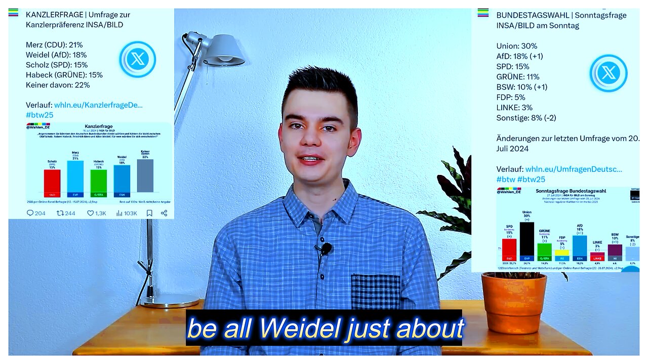
Alice Weidel is on the verge of becoming the number 1 candidate for chancellor in Germany! This new data is explosive!
New miracle victory for AfD, Weidel rejoices! Despite all the defamation against the Alternative for Germany, the verdict of the Germans is clear: Alice Weidel is taken seriously as a candidate for chancellor and can take on Friedrich Merz, while she outclasses Habeck. These new data give the AfD a boost! The AfD has obviously made the turning point in time for the elections in Saxony and Thuringia and is rising again in all polls! No wonder that sheer panic is breaking out among the old parties and that Lanz's only concern is to ban the AfD. September will be exciting.
Watch and share my new video about it here, July 30, 2024
---
@nikitheblogger YouTuber with 300,000
Without you, my work would no longer exist! I would like to thank from the bottom of my heart everyone who voluntarily supports my journalistic work financially: https://www.paypal.com/donate/?hosted...
Bank details: IBAN: DE21610500000049098011 BIC: GOPSDE6GXXX Account holder: Niklas Lotz
@nikitheblogger YouTuber with 300,000 subscribers, freelance journalist and political blogger Media personality youtube.com/@neverforgetni...Seit December 2016 at X
---
The Fault in Our ForecastsDer Fehler in unseren Prognosen
It’s impossible to predict when an earthquake will strike. This puts seismologists in a nearly impossible bind: how can they convince the public to take earthquakes seriously without crying wolf?Es ist unmöglich vorherzusagen, wann ein Erdbeben auftreten wird. Das bringt Seismologen in eine schier unmögliche Zwickmühle: Wie können sie die Öffentlichkeit davon überzeugen, Erdbeben ernst zu nehmen, ohne den Wolf zu schreien?
Asterisk MagazineAsterisk Magazin
Jul 12, 202412. Juli 2024
By Susan Hough
Read at asteriskmag.com
As a meeting broke up days after a major earthquake hit Southern California back in the 1990s, one of my colleagues quipped, “Did anyone predict it?”
Another colleague responded, “Not yet.”
The assembled group of earthquake scientists — exhausted and maybe a little punchy — chuckled at the jokes, one in the question and one in the answer. In many earthquake-prone areas, communities of amateur would-be predictors broadcast a stream of predictions that fit a certain mold: high on drama, low on specifics. “A damaging earthquake will strike in California or Japan in the coming weeks!” “California will be hit by a series of major earthquakes in 1995!” And so on.
In days of old these predictions were mostly distributed by mail. Now, of course, they are plastered far and wide on the interwebs. One hesitates to elevate any of the would-be predictors, but a Twitter search for “earthquake prediction” will find them quickly enough. So it sometimes feels surprising that any significant earthquake occurs that does not fit within the umbrella of someone’s prediction — hence the joke in the question. Then there was the answer: Claims of predictions come out of the woodwork especially quickly after an earthquake strikes. Sometimes would-be predictors rush to take credit, pointing back to an earlier vague prediction without concern for pesky details like magnitude, location, or time frame. Sometimes earlier predictions are so broad that virtually any notable earthquake can be claimed as a hit.
And without question, major earthquakes beget earthquake predictions. In the aftermath of a damaging earthquake, with aftershocks continuing to rock the area, the public’s understandable anxieties provide fertile soil for alarmist predictions of future larger quakes in the same area, or other areas. In the social media era this creates a Whac-A-Mole game, pitting a small community of scientists against moles with a dizzying array of holes from which to pop up.
The reality is that earthquake prediction is hard. “Neither the USGS nor any other scientists have ever predicted a major earthquake,” reads the official statement on the United States Geological Survey’s online FAQ. “We do not know how, and we do not expect to know how any time in the foreseeable future.” Seismologists point to three basic reasons. First, seismology is not chemistry. The Earth itself runs the experiments on its own time. To truly test a proposed prediction method, it must be applied prospectively: predicting the earthquakes that haven’t happened yet. As terrifying as they are, damaging earthquakes do not occur that frequently in any one area — at least not on timescales relevant to individuals. Second, earthquake processes play out far underground, at depths of a few kilometers to hundreds of kilometers beneath the surface. Only a small minority of fault breaks even reach the surface, and even then, observing one after the fact tells us little if anything about the physical processes that govern earthquake nucleation. Short-term weather prediction is possible because we can see weather systems brewing. There’s no way to observe what faults are doing many kilometers beneath our feet. Third, although it’s by no means proven, some evidence suggests that earthquake processes are fundamentally chaotic, the mechanics of earthquake nucleation governed by details we can’t hope to know well enough to predict future behavior of the system. Even if we could peer into the depths of fault zones, it’s possible that earthquakes would remain impossible to predict, just as avalanches remain unpredictable despite the fact that we can see the snow.
Let me stop here to make an important point. Earthquake professionals have made major strides in forecasting the long-term average rate of earthquakes in any given region. Unlike predictions, which involve meaningfully useful bounds in time, space, and magnitude, forecasts are made in terms of probabilities that an earthquake of a certain size will strike on decadal or longer timescales. For example, in 2008, seismologists predicted that there is an estimated 99.7% chance that at least one magnitude 6.7 or greater earthquake will occur in California over the next 30 years. Based on long-term odds, seismologists are known to tell the public that “it’s not a question of if, it’s a question of when” a damaging earthquake will strike.
Seismologists are also pretty good at predicting how the ground will shake if an earthquake with a specified magnitude occurs on a specified fault. These calculations tell us what we need to know to build resilient structures and infrastructure. If the built environment can withstand earthquakes well, as is possible with modern engineering and construction techniques, loss of life in earthquakes will never drop to zero, but death tolls can be counted in tens instead of tens or even hundreds of thousands.
Modern early warning systems can also send short warnings of a few seconds to maybe tens of seconds before the strongest shaking reaches their location. These systems rely on well-established physics: If you can detect a large earthquake is underway very quickly after it starts, you can potentially send a warning to people who have not yet felt shaking. The fastest seismic waves travel at the speed of sound, whereas an alert can be sent at the speed of light. Early warning systems are of little use if a big earthquake strikes close to where you are. But they can offer a little piece of mind.
Finally, seismologists can provide people a heads-up about potential earthquakes by using the established statistics of earthquake sequences. In California, for example, there is a roughly 1 in 20 chance that any earthquake will be followed by a larger earthquake within a few days. If something bigger happens, the odds are that it will only be a little bigger than the first quake. The bigger the initial quake, the higher the odds that a subsequent earthquake will be big. So ironically, statistics tell us that the odds of a major quake are highest immediately after a major quake has just struck. After a magnitude 6.5 quake hit the Mojave Desert region near Ridgecrest on the Fourth of July in 2019, scientists briefed local officials on the potential for a subsequent earthquake. The magnitude 7.1 Ridgecrest earthquake jolted the region the night of July 5. (That 2008 report was borne out.) But forecasts like this have obvious limitations: One can’t take too many actions for an eventuality that will not happen 19 times out of 20.
In many of the ways that matter, earthquakes are not entirely mercurial. Scientists can identify earthquake-prone areas and map out expected shaking sufficiently to design earthquake-resilient buildings and infrastructure. The problem is that the unpredictability of earthquakes strikes the very core of our sense of equanimity with the world. Earthquakes scare us. People who experience severe seismic ground motion are often left shaken, in every sense of the word. For some the trauma lingers.
People want earthquakes to be predictable. Seismologists can’t predict earthquakes. But in some areas especially we know that damaging earthquakes are inevitable. This poses profound communications challenges for earthquake professionals. We understand the risks, and know that they need to be taken seriously by individuals, officials, and stakeholders. At the same time, if we cry wolf too many times, the message will be tuned out, or worse, it can backfire. Earthquake professionals find ourselves walking a fine line. The earliest days of earthquake exploration — with lessons as relevant now as they were a century ago — show just how fine.
***
In the 19th century, a number of moderately damaging earthquakes, including the 1868 Hayward Fault earthquake (estimated around magnitude 6.5-7.0), struck the Bay Area not long after the Gold Rush drew settlers of European descent to the region. The forty-niners brought to California many tools and technologies, chief among them a tradition of written recordkeeping and skill in surveying.
Detail of a seismogram of the 1906 San Francisco earthquake. Photo: Remington Stone.
The 1906 San Francisco earthquake put a magnitude 7.9 exclamation point on what scientists and the public already knew by that time: that earthquakes were a real and present danger in the San Francisco Bay Area. Following the 1906 earthquake, geologists mapped first the fault break, and then kept going, over poison oak-laden hill and rattlesnake-infested dale, until they had mapped nearly the full extent of the 800-mile San Andreas Fault. It would be another five decades before the development of plate tectonics theory provided the framework to understand its significance: The fault is part of a major boundary between two tectonic plates. In the early 20th century scientists had only vague (and wrong) theories about why the Earth has active faults such as the San Andreas. But by 1910 scientists knew the fault was there, and they knew it hosted major earthquakes. Signs of the great Fort Tejon earthquake of 1857 (estimated at magnitude 7.9), which broke the central segment of the San Andreas, would still have been reasonably fresh in 1906.
Soon, scientists began to think about the impacts of earthquakes in the greater Los Angeles area, which started to grow as a population center after oil was discovered around 1900. Foremost among them was Harry Oscar Wood, a geologist at the University of California, Berkeley, who turned his attention to seismology after the great San Francisco quake. In 1921 — after years spent mapping the faults of Northern California and a stint operating the seismic research station at the Hawaiian Volcano Observatory — Wood sought funding from the Carnegie Institution to start a new seismological laboratory in Pasadena. Thanks in no small part to oil explorations, geologists already knew that the San Andreas Fault skirts the mountains north of the greater Los Angeles area. Over the next several years, Wood’s team identified many of the faults within the Los Angeles Basin itself. A study in the 1920s concluded that the Newport-Inglewood Fault was likely a major throughgoing fault, creating a series of aligned hills that poke up from the flat-lying basin.
Through the 1920s a debate ensued, splitting geologists into two camps. Was earthquake hazard in the greater Los Angeles area on par with that in the SF Bay Area? Was the region at risk of massive earthquakes like those of 1868 or 1906? No scientist of the day discounted earthquake hazard in the Southland entirely. Indeed, locally damaging shocks had occurred, including an estimated magnitude 4.9 shock that damaged brick buildings in Inglewood in 1920. Still, scientists appreciated the vast difference between a locally damaging shock and a major earthquake like 1906.
Many scientists saw evidence that the hazard was high enough to take seriously. Among them were Wood and Stanford geologist Bailey Willis, another pioneering figure in 20th-century seismology. Willis — who started his career as an engineer — was an early and energetic advocate for earthquake-safe construction. The son of early abolitionist Cornelia Grinnell Willis and poet Nathaniel Parker Willis, he came by his progressive views and talent for oratory naturally. Unlike most of his peers, he was eager to speak to journalists and the public about the dangers earthquakes posed to the region. In 1923, Wood and Willis produced an earthquake map of California, which traced the faults along which earthquakes would be expected to occur — including in Los Angeles.
In the opposite camp, public officials and captains of industry, as well as geologists with industry ties, were keen to play down earthquake hazard — or at least talk of earthquake hazard that would scare away needed capital from back East. Robert T. Hill, sometimes called the father of Texas geology, was their most prominent spokesman. Hill and his colleagues had not-unreasonable arguments as to why Los Angeles had much less cause for concern. The existence of oil and gas fields suggested that the basin’s faults had remained tightly sealed over geological time. Major earthquakes, the thinking went, would disrupt the so-called fault seals required for oil and gas to pool. Geologists also pointed to the 1886 Charleston, South Carolina, earthquake, which had been felt at (and caused damage to) far greater distances than earthquakes in California. Compared to that, and to 1906, the earthquake history of Southern California seemed tame. Scientists understand now what wasn’t known then: that the long reach of earthquakes back East is due to the nature of the Earth’s crust, not magnitude per se. The shaking from the Charleston earthquake was felt at greater distances than the 1906 San Francisco earthquake not because the former quake was bigger (it was smaller), but because seismic waves travel more efficiently through the eastern half of the country. Quite a few things about earthquakes were not understood 100 years ago.
In 1925, as the great quake debate was ramping up, an estimated magnitude 6.5 earthquake struck near Santa Barbara, taking a toll on that city, and generating shaking felt throughout the Los Angeles area. (Willis just happened to be in the area at the time; his dispatch to The New York Times notes that the buildings that remained undamaged were “well constructed.”) In 1925, Santa Barbara was considered far enough from Los Angeles that this quake did not raise immediate concerns for hazard throughout the Southland. But the 1925 earthquake did capture headlines, for a time.
While Wood continued to build out his seismic monitoring network, Willis pushed for the city government of Santa Barbara (and that of his hometown of Palo Alto) to adopt more earthquake-resistant building codes. He also lent his energy and communications talents to an early push for data from level surveys that could establish the precise elevation along transects (straight lines across the landscape used by geologists to take standardized measurements). Scientists believed that these leveling surveys could indicate directly if strain was building up in the crust. (Modern science has borne out this idea, although gradual warping of the ground has not to date proven useful for short-term prediction.) The U.S. government was involved with collection of leveling data, the elevation and elevation changes of the land being of interest for any number of governmental reasons.
Indeed, analysis of early leveling data collected by the Coast and Geodetic Survey (the nation’s first civilian scientific agency, responsible for surveying the country’s coastline) in the years leading up to 1920 appeared to show an alarming result, indicating a high rate of strain in Southern California. This result was not initially publicized, for reasons a modern scientist can guess at, and appreciate. First, the measurements themselves were uncertain. Secondly, even if the estimate was accurate, what did the leveling data actually say about earthquake risk? Herein lies a key communication challenge: If scientific results leave scientists concerned, but we aren’t sure what they mean, what, if anything, do we say about them? In the early 20th century as now, earthquake scientists are mindful of the need to not cry wolf.
Map of the destruction zone of the 1933 Long Beach earthquake from a souvenir booklet that was published shortly afterwards. Courtesy Flickr.
Resultant horizontal motion at Los Angeles during first 15 seconds of Long Beach earthquake. Courtesy NOAA.
Back in 1925 the leveling results circulated among professional groups — out of the public eye. A few months after Santa Barbara, as interest in earthquakes waned, Willis began to make bolder statements. In the words of historian Carl-Henry Geschwind, “he would scare Californians by not only pointing backward at the recent seismic destruction but also predicting that a catastrophic earthquake … would soon strike southern California.” Willis never quite made a clear-cut prediction, though he danced as close to the line as a scientist could get. In late 1925, he told a reporter, “No one knows whether it will be one year or ten before a severe earthquake comes, but when it does it will come suddenly, and those who are not prepared will suffer.” While this statement drew from his scientific understanding, it was motivated by his keen interest in promoting preparedness. If Willis stopped short of making a clear prediction, the media, within and beyond California, naturally (and not unreasonably) took the last step. An article ran in The New York Times with the headline “Prof. Willis Predicts Los Angeles Tremors.” Readers were told that according to Willis, Los Angeles “will experience a severe earthquake … in one to ten years.”
***
Willis’ prediction brought a simmering debate out of the shadows, with dollars-and-cents consequences. Insurance rates skyrocketed, impacting the commercial real estate world. Business leaders redoubled efforts to push back. So did geologists. By 1927, scientists had reconsidered the leveling data on which the prediction had been made, and found the conclusion resulted primarily from errors — a technical knockout for Willis. Following a series of articles and speeches, Robert T. Hill published a book in 1928, an entire chapter of which focused on dismantling what he called Willis’ “inconsiderate, inaccurate, and damaging prophecies.” Not all of the statements in Hill’s book have aged well (he also claimed that “judging from past history, it cannot be said that there is any great menace from the [Newport-]Inglewood [Fault].”) But much of the book was based on sound science, including his arguments against Willis. To Hill, at least, the consequences of crying wolf were clear: “The author of these fearsome predictions,” he wrote, “is a scientific man of standing but in my opinion he has ... done more to discredit science in the minds of the people of this vicinity than any other incident in recent years.”
The collapse of Willis’ prediction was not the death knell of ongoing efforts to better understand earthquake hazard in the region. By 1927 the Carnegie Institution had funded Wood’s proposal to build and install seismometers throughout Southern California. Wood had teamed up with astronomer John A. Anderson to create a new kind of seismometer to record local shocks. As data started to be recorded, the Seismo Lab brought a researcher on board to start to work with the data, a 27-year-old with a freshly minted Ph.D. in physics from the California Institute of Technology: Charles Francis Richter. A few short years after that, Richter developed the first-ever scale to measure earthquake strength.
But while the untidy death of Willis’ prediction may not have marked the death of earthquake exploration, it did serve to quell public talk of earthquake hazard. This may have been the chief aim of local business leaders — not to dismiss earthquake hazard per se, but rather to put a stop to public statements that could interfere with their ambitions. Building developers had especially bristled at talk of earthquakes that could scare away needed capital from institutions back East, and drive up insurance rates at home. As early earthquake scientists went about their business, they kept their powder dry, avoiding statements to the public or press. In the late ’20s and opening years of the ’30s, earthquakes were safely out of sight, out of mind. As the greater Los Angeles area continued to grow, residents and newcomers gave little thought to earthquakes. Rumblings were felt from time to time, but usually minor, never more than very locally damaging.
City Hall, Compton, after the 1933 Long Beach Earthquake. Courtesy Flickr.
The Earth itself put an end to the great quake debate once and for all on the evening of March 10, 1933, when the Newport-Inglewood Fault showed that it can in fact pose a great menace to those living nearby. Now estimated at magnitude 6.4-6.5, the 1933 Long Beach earthquake killed over 100 people and left a swath of damage from Long Beach through Compton and beyond. At the time, some area residents were entirely unaware of earthquake risk. Selma Gugliemo, then a schoolgirl living in Long Beach, described clinging to her mother as the Earth rattled around them. Selma, having no knowledge of earthquakes, described the experience: “we thought it was the end of the world.” After an agonizing wait, Selma and her family learned that her brother Tony had been killed in a school collapse, having gone back inside after a track meet to shower — reportedly the only child killed in a school building that awful day. California public school buildings had sprouted up like mushrooms as the population grew rapidly in the early 20th century. These larger masonry structures took a heavy toll when the Long Beach earthquake struck. Only the timing of the earthquake, near 6 p.m. local time, kept the tragedy from being much greater. Had earthquake hazard been recognized when Wood first began his advocacy, steps could have been taken to improve resilience of public school buildings.
In the aftermath of the Long Beach quake, California moved quickly to mitigate risk. On April 10, the governor signed into law the Field Act, establishing a strict review process for public school buildings. This was followed by the Riley Act on May 26, which required cities to establish departments to review and approve building plans for earthquake safety. Other cities — including Long Beach — adopted even stricter earthquake codes, modeled after the code Willis proposed for Santa Barbara. Great progress has been made toward preparedness at many levels including building codes and freeway retrofitting. Nearly a century later, much has changed.
But some things haven’t. Earthquakes remain unpredictable. The proverbial “Big One” — the next magnitude 8(ish) earthquake on the San Andreas Fault (or possibly a magnitude 7+ quake close to population centers) remains a real and present danger. It is a question of when, not if. But if concern motivates, fear often paralyzes. Earthquake professionals still contend with the line that Bailey Willis and his contemporaries danced around. That line remains impossibly fine. Balanced talk of earthquake risks is easily tuned out in a world that is never short on immediate concerns. Alarmist talk gets people’s attention, for a time, and then it backfires. If scientists make hay over that 1 in 20 chance, we will appear to have cried wolf 19 times out of 20. But it remains incumbent on the scientists who best understand the hazard to navigate the fine line, communicating to residents, officials, and other stakeholders. Perhaps lessons from sociology help scientists communicate more effectively, in a way that motivates preparedness actions that can make a real difference when an earthquake strikes. Meaningful risk reduction hinges on steps taken by everyone impacted by earthquakes — including the public at large. Earthquake risk reduction is a process, and it takes a village to move that process forward.
Susan Hough is a research seismologist, a Fellow of the American Geophysical Union, and a science writer. Recent books include The Great Quake Debate (University of Washington Press) and Predicting the Unpredictable (Princeton University Press). https://open.substack.com/pub/asteriskmag/p/the-fault-in-our-forecasts?r=45fjjl&utm_campaign=post&utm_medium=web
---
Text is available under the Creative Commons Attribution-ShareAlike License; additional terms may apply. See Terms of Use for details.
-
 LIVE
LIVE
Game On!
13 hours agoTampa Bay Welcomes Jon Gruden BACK!
1,346 watching -
 20:40
20:40
Degenerate Jay
21 hours agoWhy So Many Hate The Fable Game Series
8.83K2 -
 5:19
5:19
Kirill MultitoolOfficial
20 hours agoUSEFUL Survival SKILLS and SMART camping LifeHACKS in the wilderness!
4.71K3 -
 38:57
38:57
PMG
20 hours agoHannah Faulkner and Brandon Tatum | BREAKING THE CHAINS: Exposing the Left’s Manipulation
5.55K -
 0:50
0:50
Sean Unpaved
15 hours ago $9.18 earnedWelcome “Unpaved w/ Sean Salisbury” to Rumble
59.4K14 -
 2:10:09
FreshandFit
9 hours agoKicking Out Old Annoying Hoes In Las Vegas!
87.8K118 -
 25:53
25:53
Stephen Gardner
12 hours ago🔥BREAKING: Trump HATING LAWYER busted in $17 million money laundering scheme!
56K144 -
 20:10
20:10
CartierFamily
18 hours agoAndrew Schulz DESTROYS Charlamagne’s WOKE Meltdown on DOGE & Elon Musk!
135K104 -
 33:56
33:56
The Why Files
9 days agoLegend of the 13 Crystal Skulls | From Mars to the Maya
94.1K44 -
 2:56:14
TimcastIRL
12 hours agoEPSTEIN Files DROP, FBI GOES ROGUE, AG Says They COVERED UP Epstein Case w/Amber Duke | Timcast IRL
221K145