Premium Only Content

FLORIDA HURRICANE? GFS Location: MY #HOME 🙏🏽🙏🏽🙏🏽
North Atlantic...Caribbean Sea and the Gulf of Mexico:
1. Near the Lesser and Greater Antilles:
An area of disturbed weather over the central tropical Atlantic
Ocean is expected to interact with an approaching tropical wave
during the next several days. Development of this system is possible
while it approaches the Lesser Antilles during the early to middle
part of next week and moves generally west-northwestward near or
over the Greater Antilles towards the latter part of next week.
* Formation chance through 48 hours...low...near 0 percent.
* Formation chance through 7 days...low...30 percent.
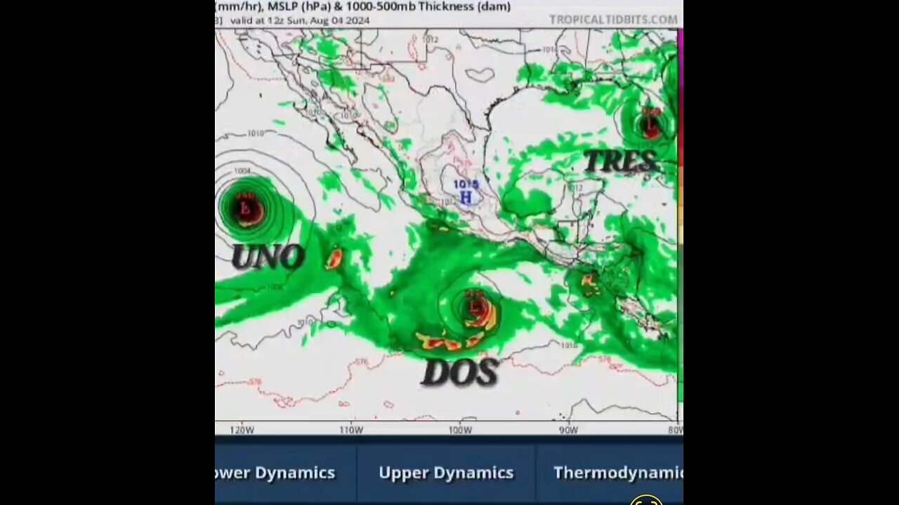
1. South of Southern Mexico:
An area of low pressure is forecast to form by the middle of next
week a few hundred miles south of the coast of southern Mexico.
Environmental conditions appear conducive for gradual development of
this system, and a tropical depression could form during the middle
or latter part of next week. This system is forecast to move
west-northwestward at 10 to 15 mph, roughly parallel to the coast of
southwestern Mexico.
* Formation chance through 48 hours...low...near 0 percent.
* Formation chance through 7 days...medium...50 percent.
2. Western East Pacific:
Another area of low pressure could form by the middle of next week
well to the southwest of the southern tip of the Baja California
Peninsula. Some slow development of this system is possible during
the middle and latter parts of next week while it moves westward to
west-northwestward across the western portion of the basin.
* Formation chance through 48 hours...low...near 0 percent.
* Formation chance through 7 days...low...30 percent.
#GFS and #ECMWF #ICON #NAVGEM suggests significant deepening as Beryl approaches the coastline of northeastern Mexico and south Texas. Somewhat surprisingly, the #corpuschristi hurricane-regional models are more subdued and suggest less intensification this cycle, but these models have been oscillating between stronger and weaker solutions. The latest NHC intensity forecast will show a bit more intensification than the prior advisory, which is on the high end of the intensity guidance, but more in line with the expected favorable environment as Beryl approaches #landfall . #Friday #Saturday #lousiana lousia #Sunday #Monday #rain #hurricaneberyl #Hurricanes #hurricanewind #Houston #Texas #louisiana #Mexico #cancun #Yucatan #cropuschristi #severe #hurricane #Hurricanes #rainfall #flooding #vacation #travel #tropicalcyclone #tropics #Saturday
#jamaican #Mèxico #storms #aletta #tropicalstorm #tropics #hurricanewind #hurricaneberyl #hurricane #hurricanes
#Beryl is expected to remain a powerful hurricane as it moves across the #Caribbean #Sea later this week and interests in #Hispaniola #Jamaica the Cayman Islands and the remainder of the northwestern #Caribbean should monitor its progress, There is large #forecast uncertainty at days 4 and 5 and users should not focus on the specific details of the track or intensity #forecast #weather #zoomearth #severe #hurricaneberyl #storm #storms #flooding #poweroutages #power #electricity #meterologist #jamaica #DominicanRepublic #haiti #TiffanysContent #weatherreport #puertorico #Houston #Texas #TexasHurricane #Yucatan #Mexico #berylpath #hurricanewarning #Louisiana #Arkansas #tennessee #mississippi #gulfofmexico #gulfcoast #rain #windy #surge #stormsurge #poweroutages #usa #stormdamage #weather #weatherevent #weathernews #TiffanysContent #meterologist
www.pivotalweather.com
www.tropicaltidbits.com
www.nhc.noaa.gov
www.star.nesdis.noaa.gov
www.zoom.earth.com
www.weather.gov
-
 12:13
12:13
Russell Brand
1 day agoThe Most Dishonest News Reporting You'll Ever See
55.4K132 -
 39:13
39:13
Rethinking the Dollar
1 hour agoSilver's Flirting With a 12-Year High—Is This the Big Breakout? | Morning Check-In
4.97K2 -
 15:38
15:38
Professor Nez
1 hour ago🚨LBJ Phone Call to Jackie Kennedy is the WEIRDEST THING I've EVER Heard! JFK Files Analysis
11.6K44 -
 1:26:12
Michael Franzese
16 hours agoTrump Dismantles DOE, Musk Saves Astronauts, Tesla Under Attack | LIVE
22.3K10 -
 5:18:42
EXPBLESS
5 hours agoNEW CLIX SKIN COMING TO THE ITE M SHOP - MAX XP ON FORTNITE
69.7K10 -
 LIVE
LIVE
Anvilight
4 hours agoFortnite | Saturday Morning Stream! | Creator Program Day #22
297 watching -
 14:16
14:16
Talk Nerdy Sports - The Ultimate Sports Betting Podcast
2 hours ago3/22/25 - March Madness: Who Wins Today? Vas & Riste Pick Every Game!
24.4K1 -
 3:02:33
RG_GerkClan
5 hours ago🔴LIVE - Lets Dominate this Weekend - Escape From Tarkov - Gerk Clan
38.7K2 -
 4:59:23
SoundBoardLord
5 hours ago90's Saturday Morning Cartoons, Chill Vibes & Great Conversations
33.5K -
 13:55
13:55
ThinkStory
1 day ago107 Hidden Clues & Details You Missed In Severance Season 2!
34.3K2