NBC26 Storm Shield Weather Forecast
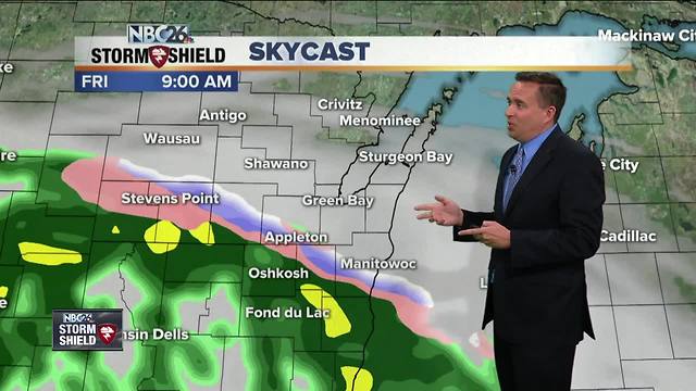
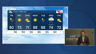
Most of tonight looks quiet, though if you live to the south, you could a a light rain shower overnight or possibly a few flurries by daybreak. Either way, most of tonight will be fine for most of us with lows only in the mid-30s....frost is possible NW of Fox Valley. There is going to be a sharp cutoff as to who sees rain on Friday, and who stays dry. The farther you live to the south of Highway 29, the more rain you'll probably see. The farther north, the better your chance of staying completely dry. Gusty NE winds off of Lake Michigan will keep temps only in the 40s, which is 15-20° below normal for mid-May. This same rain scenario will continue going into Friday night. The farther south you live, the more rain you'll see. Lows will bottom out in the upper-30s. Current model trends are actually trying to push the frontal boundary into southern Wisconsin for Saturday. That would mean much less rain for us. Either way, it's going to be kind of cool with highs in the upper-50s. Basically, if the front stays south, most of your Saturday will be okay. Mother's Day Sunday looks fairly decent with highs in the mid-60s. There will be a slight chance of a shower with a weak wave rolling through, but most of the day will be fine. Warm temperatures getting close to 80 will return for Monday. The Wolf River near Shiocton, & New London remain under a River Flood Warning for the time being with minor flooding currently being observed. The Fox River is experiencing minor flooding in Green Lake County.
-
 3:36
3:36
WGBA
1 year agoWill it be necessary to have both the AC & the heat on during the same day??
3161 -
 3:24
3:24
WGBA
4 years agoNBC26 Storm Shield Forecast
6 -
 3:24
3:24
WGBA
4 years agoNBC26 Storm Shield Forecast
8 -
 1:29
1:29
WGBA
4 years agoNBC26 Storm Shield Forecast
7 -
 4:01
4:01
WGBA
4 years agoNBC26 Storm Shield Forecast
15 -
 3:38
3:38
WGBA
4 years agoNBC26 Storm Shield Forecast
12 -
 3:17
3:17
WGBA
4 years agoNBC26 Storm Shield Forecast
11 -
 1:32
1:32
WGBA
4 years agoNBC26 Storm Shield Forecast
4 -
 3:35
3:35
WGBA
4 years agoNBC26 Storm Shield Forecast
7 -
 3:51
3:51
WGBA
4 years agoNBC26 Storm Shield Forecast
7