Michael Fish's NBC26 Storm Shield weather forecast
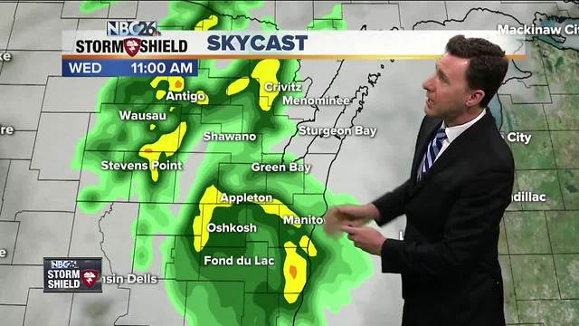
Areas of rain or possibly a T'storm will be rolling through the area at times. Highs won't be as warm today with 60s expected. Rain totals could end up over 0.50", which isn't that much, but many of our waterways are full. If there's a lingering shower or T'storm in the evening, that's going to end. Overnight lows will be around 50. Thursday, we should have a break with highs in the low- to mid-60s. We should see some sunshine. By Friday, our temperatures will only be in the 40s. Rain looks to develop late Thursday night going into Friday. Right now, the placement of a stationary front is going to be key as to who sees the most rain. Gusty NE winds off of Lake Michigan will keep temps 15-20° below normal for mid-May. Current model trends are actually trying to push the frontal boundary into southern Wisconsin for Saturday. That would mean much less rain for us. Either way, it's going to be chilly with highs only in the low-50s. Sunday through next Tuesday looks milder and dry. The Wolf River near Shiocton, & New London remain under a River Flood Warning for the time being with minor flooding currently being observed. The Fox River is experiencing minor flooding in Green Lake County.
-
 1:57
1:57
WGBA
1 year agoHow the City of Green Bay is hoping a $1.6M investment will make the community safer for pedestrians
3762 -
 2:46
2:46
WGBA
4 years agoMichael Fish's NBC 26 weather forecast
5 -
 2:30
2:30
WGBA
4 years agoMichael Fish's NBC 26 weather forecast
5 -
 2:20
2:20
WGBA
4 years agoMichael Fish's NBC 26 weather forecast
14 -
 2:21
2:21
WGBA
4 years agoMichael Fish's NBC 26 weather forecast
6 -
 2:25
2:25
WGBA
4 years agoMichael Fish's NBC 26 weather forecast
4 -
 1:55
1:55
WGBA
4 years agoMichael Fish's NBC 26 weather forecast
10 -
 2:11
2:11
WGBA
4 years agoMichael Fish's NBC 26 weather forecast
4 -
 1:50
1:50
WGBA
4 years agoMichael Fish's NBC 26 weather forecast
3 -
 1:45
1:45
WGBA
4 years agoMichael Fish's NBC 26 weather forecast
7