Premium Only Content

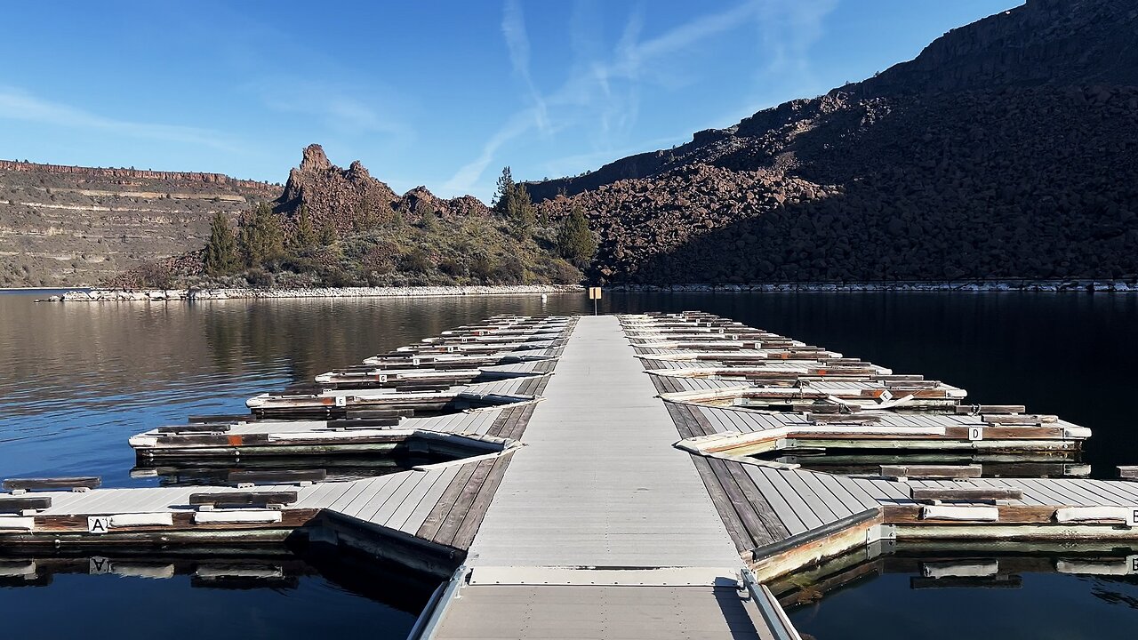
Lower Deschutes Day Use Area Boat Launch @ The Cove Palisades State Park! | Lake Billy Chinook | 4K
This 4K Video captures the Lower Deschutes Day Use Area Boat Ramp/Launch/Dock, the Floating Deployable Restrooms, the Day Use Picnic Sites on the Shoreline, and the Designated Swimming Area of the incredible Deschutes Arm of Lake Billy Chinook, and finishes with some Silent Perspectives of absolutely gorgeous and incredible Lake Billy Chinook!
***Please note that Google Maps is wrong. There is an Upper Deschutes Day Use Area AND a Lower Deschutes Day Use Area. They are nearby each other, both have their own Ramp/Launch/Dock, and they are connected by a Shoreline Trail. For some reason Google Maps has the Upper Deschutes Day Use Area INACCURATELY labeled as the Lower Deschutes Day Use Area, and doesn't have the Lower Deschutes Day Use Area even labeled AT ALL even though it acknowledges the Boat Ramp and infrastructure is there.....so this IS correct, Google Maps is wrong.***
The Cove Palisades State Park is easily a Top 3 State Park in the entire State of Oregon! Lake Billy Chinook's claim to fame is that its the confluence of 3 National Wild & Scenic Rivers - Crooked River, Deschutes River & Metolius River into a truly EPIC Lake-River-Canyon High Desert Wonderland! Thus this multi-tendrilled Lake is broken up into the Crooked River Arm, Deschutes River Arm & Metolius River Arm, each with its own very well developed infrastructure of Day Use Areas, Boat Ramp/Launches and very well groomed & manicured Shoreline Hiking Trails. Lake Billy Chinook is truly a World-Class Watersport Mecca of Boating, Fishing & Kayaking.
This area was explored on March 19, 2024. The weather was in the 30's in the AM up the the 50's by late afternoon. Due to some pre-scheduled hydroelectric dam work by PGE, the water levels were 2 FT - 5 FT lower than normal, with water levels expected to return back up to normal levels within weeks before peak season.
The road is very well paved throughout The Cove Palisades State Park and all the way through to Perry South Campground. From Perry South Campground to Monty Campground it is a relatively bumpy Forest Road - most cars should be able to make it if you drive slowly and cautiously, particularly around some blind corners on a very steep road, so exercise maximum caution driving to Monty Campground! That said, if done prudently, it is not a difficult drive, high clearance and 4WD are NOT required in my humble opinion. Always check for weather and of course do so at your own risk!
-
 3:01
3:01
HikingViking
6 days agoFINAL REVIEW Strategies & Tips Descending Tamanawas Falls Trail | 4K Winter Ice Snow Hiking Mt. Hood
871 -
 49:57
49:57
The Dan Bongino Show
4 hours agoAnother Phony Narrative Crumbles + First Show In The New Studio! (Ep. 2437) - 03/06/2025
619K1.76K -
 44:26
44:26
The Rubin Report
3 hours ago'Real Time' Crowd Stunned by Bill Maher’s Unexpected Glaring Blind Spot
44.2K36 -
 1:45:31
Benny Johnson
3 hours agoDeep State PURGE: CIA Agents STRIPPED of Badges as Trump DISMANTLES Dept of Education | Dem CENSURED
79.6K90 -
 55:56
55:56
Grant Stinchfield
2 hours ago $0.91 earnedWhat Happened to the Mystery Drones? They Don't Just Disappear, or do They?
21.7K2 -
 1:17:41
Flyover Conservatives
13 hours agoThe Medical Industry’s Dark Secret—What They Don’t Want Pregnant Women to Know! - Dr. James Thorp | FOC Show
28.6K -
 1:01:32
Standpoint with Gabe Groisman
2 days agoThe War on Israel: Yair Netanyahu Tells All
28.9K10 -
 2:10:19
Steven Crowder
5 hours agoTrump Loves Dictators: Debunking the Left’s Latest Attack Strategy
384K260 -
 1:03:38
Timcast
4 hours agoTrump Eyes CRIMINAL CHARGES For USAID Staff For FRAUD, SCOTUS Under Fire Over Ruling On $2B Payments
78.2K51 -
 2:02:54
LFA TV
18 hours agoBYE, BYE OBAMA AND BLM! | LIVE FROM AMERICA 3.6.25 11AM
53.5K25