Premium Only Content

NASA ARSET: Detecting and Monitoring Floods with SAR, Part 3/3
SAR for Detecting and Monitoring Floods, Sea Ice, and Subsidence from Groundwater Extraction
Part 3: Detecting and Monitoring Floods with SAR
Trainers: Erika Podest (JPL)
Guest Speakers: Franz Meyer (Alaska Satellite Facility/University of Alaska, Fairbanks)
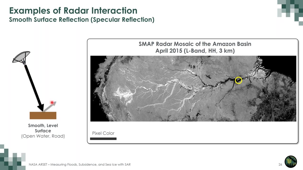
Floods are becoming more prevalent and intense. Monitoring these events, their extent, evolution, and impacts can be difficult with optical remote sensing data because cloud cover tends to be prevalent during floods. SAR can penetrate through the clouds and detect inundation regardless of day/night conditions. Information on the dynamic nature of these events can help inform disaster response and recovery efforts. This session will provide a summary of the theory of SAR for detecting floods followed by a demo using Jupyter Notebook and ASF tools to show how to generate flood maps with time series Sentinel-1 data to monitor the increase/decrease of flood waters.
You can access all training materials from this webinar series on the training webpage: https://go.nasa.gov/3PwmgAs
This training was created by NASA's Applied Remote Sensing Training Program (ARSET). ARSET is a part of NASA's Applied Science's Capacity Building Program. Learn more about ARSET: https://appliedsciences.nasa.gov/what...
-
 LIVE
LIVE
LittleDude games
4 hours agoSaturday Fortnite Hunters // LittleDude
970 watching -
 14:34
14:34
Misha Petrov
14 hours agoTikTok’s WOKE “Mean Girl” Is Insufferable
18.9K44 -
 10:46
10:46
Mike Rowe
1 day agoRiley Gaines Was Right All Along | The Way I Heard It with Mike Rowe
49.2K73 -
 25:19
25:19
SB Mowing
1 day agoI had to do a DOUBLE TAKE because I couldn’t see the house at first
27.5K17 -
 LIVE
LIVE
I_Came_With_Fire_Podcast
10 hours agoChina's Global Strategy, US Military Challenges, & The Battle for Influence
199 watching -
 2:37:42
FreshandFit
14 hours agoGreg Doucette Guessed Their Body Fat Percentages And THIS Happened...
113K113 -
 5:08:30
Akademiks
14 hours agoKendrick Lamar SPEAKS for first time SINCE BEEF in new Interview. Drake preppin new album. YE WYLING
153K27 -
 2:12:17
Tucker Carlson
14 hours agoMike Benz Takes Us Down the USAID Rabbit Hole (It’s Worse Than You Think)
297K879 -
 1:47:17
Roseanne Barr
18 hours ago $40.98 earnedThe Most Offensive Comic, Leonarda Jonie | The Roseanne Barr Podcast #86
171K180 -
 51:45
51:45
Talk Nerdy 2 Us
17 hours ago🔥 Talk Nerdy 2 Us – Feb 7th: HACKED, TRACKED & UNDER ATTACK! 🔥
132K8