Premium Only Content
This video is only available to Rumble Premium subscribers. Subscribe to
enjoy exclusive content and ad-free viewing.

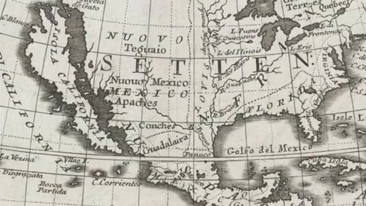
400 YEAR OLD MAPS DEPICTED CALIFORNIA AS A ISLAND
1 year ago
280
There's a piece of California history where it was once mapped as an island.
Now according to mainstream history when Spanish explorers first arrived in California, they seemed to have mistaken it for an island.
Apparently the island of California stretched nearly the entire North American Pacific coast and was thought of as an island paradise. They say that it was one of the biggest mapping errors in human history.
But how does a mistake like this even happen? AND why did California Island still appear on maps for centuries after it's initial discovery, and what caused k cartographers to be so split on the issue?
Loading comments...
-
 2:00:46
Steven Crowder
3 hours ago🔴 Fight! Major Lawsuit Announcement...
230K160 -
 LIVE
LIVE
The Charlie Kirk Show
20 minutes agoTHE CHARLIE KIRK SHOW IS LIVE 02.19.25
5,923 watching -
 1:00:47
The Dan Bongino Show
2 hours agoWhat Did Zelensky Know? When Did He Know It? (Ep. 2426) - 02/19/2025
209K454 -

Benny Johnson
1 hour ago🚨Kash Patel WINS Critical FBI Director Confirmation Vote as Trump MASS FIRES Deep State Prosecutors
12.5K23 -
 1:08:01
Timcast
2 hours agoDemocrats PANIC Over Trump Order To "Seize Control" Of Federal Agencies, Trump Asserts FULL Control
76.5K52 -
 55:32
55:32
MYLUNCHBREAK CHANNEL PAGE
17 hours agoA Little Help From Angels?
10.5K8 -
 LIVE
LIVE
LFA TV
16 hours agoLET'S KASH IN! | LIVE FROM AMERICA 2.19.25 11AM
5,189 watching -
 LIVE
LIVE
Caleb Hammer
1 hour agoChildish Couple Won’t Stop Cheating On Each Other | Financial Audit
177 watching -
 23:18
23:18
Crowder Bits
4 hours agoDebunked: John Oliver's Outrageous Lies About Trump 2.0
27.8K23 -
 2:16:08
Matt Kohrs
12 hours agoMarket Open: Key Options Levels & Breaking News || The MK Show
32.9K1