Volcano Eruption from the International Space Station
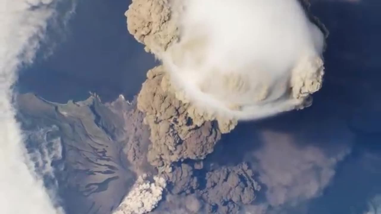
On June 12, 2009, a fortuitous orbit of the International Space Station (ISS) made it possible for an astronaut on board to capture Sarychev Volcano in the early stages of eruption. The volcano is located on the northwestern end of Matua Island, which is part of the Kuril Islands, a chain of 56 islands northeast of Japan. The eruption sent a plume of brown-colored ash and white steam rising into the atmosphere. The plume was so immense that it cast a large shadow on the island. Sarychev is one of the most active volcanoes in the Kuril Island chain. Prior to June 12, the last explosive eruption occurred in 1989, with eruptions in 1986, 1976, 1954, and 1946 also producing lava flows. Watch the video to see how the eruption looked from space. A fortuitous orbit of the International Space Station allowed the astronauts this striking view of Sarychev Volcano (Kuril Islands, northeast of Japan) in an early stage of eruption on June 12, 2009. Sarychev Peak is one of the most active volcanoes in the Kuril Island chain, and it is located on the northwestern end of Matua Island. For more info: http://earthobservatory.nasa.gov/IOTD/view.php?id=38985 http://eol.jsc.nasa.gov/ http://earthobservatory.nasa.gov/ This video can be freely shared and downloaded at https://svs.gsfc.nasa.gov/11446. While the video in its entirety can be shared without permission, the music and some individual imagery may have been obtained through permission and may not be excised or remixed in other products. Specific details on such imagery may be found here: https://svs.gsfc.nasa.gov/11446. For more information on NASA’s media guidelines, visitOn June 12, 2009, a fortuitous orbit of the International Space Station (ISS) made it possible for an astronaut on board to capture Sarychev Volcano in the early stages of eruption. The volcano is located on the northwestern end of Matua Island, which is part of the Kuril Islands, a chain of 56 islands northeast of Japan. The eruption sent a plume of brown-colored ash and white steam rising into the atmosphere. The plume was so immense that it cast a large shadow on the island. Sarychev is one of the most active volcanoes in the Kuril Island chain. Prior to June 12, the last explosive eruption occurred in 1989, with eruptions in 1986, 1976, 1954, and 1946 also producing lava flows. Watch the video to see how the eruption looked from space. A fortuitous orbit of the International Space Station allowed the astronauts this striking view of Sarychev Volcano (Kuril Islands, northeast of Japan) in an early stage of eruption on June 12, 2009. Sarychev Peak is one of the most active volcanoes in the Kuril Island chain, and it is located on the northwestern end of Matua Island. For more info: http://earthobservatory.nasa.gov/IOTD/view.php?id=38985 http://eol.jsc.nasa.gov/ http://earthobservatory.nasa.gov/ This video can be freely shared and downloaded at https://svs.gsfc.nasa.gov/11446. While the video in its entirety can be shared without permission, the music and some individual imagery may have been obtained through permission and may not be excised or remixed in other products. Specific details on such imagery may be found here: https://svs.gsfc.nasa.gov/11446. For more information on NASA’s media guidelines, visitOn June 12, 2009, a fortuitous orbit of the International Space Station (ISS) made it possible for an astronaut on board to capture Sarychev Volcano in the early stages of eruption. The volcano is located on the northwestern end of Matua Island, which is part of the Kuril Islands, a chain of 56 islands northeast of Japan. The eruption sent a plume of brown-colored ash and white steam rising into the atmosphere. The plume was so immense that it cast a large shadow on the island. Sarychev is one of the most active volcanoes in the Kuril Island chain. Prior to June 12, the last explosive eruption occurred in 1989, with eruptions in 1986, 1976, 1954, and 1946 also producing lava flows. Watch the video to see how the eruption looked from space. A fortuitous orbit of the International Space Station allowed the astronauts this striking view of Sarychev Volcano (Kuril Islands, northeast of Japan) in an early stage of eruption on June 12, 2009. Sarychev Peak is one of the most active volcanoes in the Kuril Island chain, and it is located on the northwestern end of Matua Island. For more info: http://earthobservatory.nasa.gov/IOTD/view.php?id=38985 http://eol.jsc.nasa.gov/ http://earthobservatory.nasa.gov/ This video can be freely shared and downloaded at https://svs.gsfc.nasa.gov/11446. While the video in its entirety can be shared without permission, the music and some individual imagery may have been obtained through permission and may not be excised or remixed in other products. Specific details on such imagery may be found here: https://svs.gsfc.nasa.gov/11446. For more information on NASA’s media guidelines, visitOn June 12, 2009, a fortuitous orbit of the International Space Station (ISS) made it possible for an astronaut on board to capture Sarychev Volcano in the early stages of eruption. The volcano is located on the northwestern end of Matua Island, which is part of the Kuril Islands, a chain of 56 islands northeast of Japan. The eruption sent a plume of brown-colored ash and white steam rising into the atmosphere. The plume was so immense that it cast a large shadow on the island. Sarychev is one of the most active volcanoes in the Kuril Island chain. Prior to June 12, the last explosive eruption occurred in 1989, with eruptions in 1986, 1976, 1954, and 1946 also producing lava flows. Watch the video to see how the eruption looked from space. A fortuitous orbit of the International Space Station allowed the astronauts this striking view of Sarychev Volcano (Kuril Islands, northeast of Japan) in an early stage of eruption on June 12, 2009. Sarychev Peak is one of the most active volcanoes in the Kuril Island chain, and it is located on the northwestern end of Matua Island. For more info: http://earthobservatory.nasa.gov/IOTD/view.php?id=38985 http://eol.jsc.nasa.gov/ http://earthobservatory.nasa.gov/ This video can be freely shared and downloaded at https://svs.gsfc.nasa.gov/11446. While the video in its entirety can be shared without permission, the music and some individual imagery may have been obtained through permission and may not be excised or remixed in other products. Specific details on such imagery may be found here: https://svs.gsfc.nasa.gov/11446. For more information on NASA’s media guidelines, visitOn June 12, 2009, a fortuitous orbit of the International Space Station (ISS) made it possible for an astronaut on board to capture Sarychev Volcano in the early stages of eruption. The volcano is located on the northwestern end of Matua Island, which is part of the Kuril Islands, a chain of 56 islands northeast of Japan. The eruption sent a plume of brown-colored ash and white steam rising into the atmosphere. The plume was so immense that it cast a large shadow on the island. Sarychev is one of the most active volcanoes in the Kuril Island chain. Prior to June 12, the last explosive eruption occurred in 1989, with eruptions in 1986, 1976, 1954, and 1946 also producing lava flows. Watch the video to see how the eruption looked from space. A fortuitous orbit of the International Space Station allowed the astronauts this striking view of Sarychev Volcano (Kuril Islands, northeast of Japan) in an early stage of eruption on June 12, 2009. Sarychev Peak is one of the most active volcanoes in the Kuril Island chain, and it is located on the northwestern end of Matua Island. For more info: http://earthobservatory.nasa.gov/IOTD/view.php?id=38985 http://eol.jsc.nasa.gov/ http://earthobservatory.nasa.gov/ This video can be freely shared and downloaded at https://svs.gsfc.nasa.gov/11446. While the video in its entirety can be shared without permission, the music and some individual imagery may have been obtained through permission and may not be excised or remixed in other products. Specific details on such imagery may be found here: https://svs.gsfc.nasa.gov/11446. For more information on NASA’s media guidelines, visitOn June 12, 2009, a fortuitous orbit of the International Space Station (ISS) made it possible for an astronaut on board to capture Sarychev Volcano in the early stages of eruption. The volcano is located on the northwestern end of Matua Island, which is part of the Kuril Islands, a chain of 56 islands northeast of Japan. The eruption sent a plume of brown-colored ash and white steam rising into the atmosphere. The plume was so immense that it cast a large shadow on the island. Sarychev is one of the most active volcanoes in the Kuril Island chain. Prior to June 12, the last explosive eruption occurred in 1989, with eruptions in 1986, 1976, 1954, and 1946 also producing lava flows. Watch the video to see how the eruption looked from space. A fortuitous orbit of the International Space Station allowed the astronauts this striking view of Sarychev Volcano (Kuril Islands, northeast of Japan) in an early stage of eruption on June 12, 2009. Sarychev Peak is one of the most active volcanoes in the Kuril Island chain, and it is located on the northwestern end of Matua Island. For more info: http://earthobservatory.nasa.gov/IOTD/view.php?id=38985 http://eol.jsc.nasa.gov/ http://earthobservatory.nasa.gov/ This video can be freely shared and downloaded at https://svs.gsfc.nasa.gov/11446. While the video in its entirety can be shared without permission, the music and some individual imagery may have been obtained through permission and may not be excised or remixed in other products. Specific details on such imagery may be found here: https://svs.gsfc.nasa.gov/11446. For more information on NASA’s media guidelines, visitOn June 12, 2009, a fortuitous orbit of the International Space Station (ISS) made it possible for an astronaut on board to capture Sarychev Volcano in the early stages of eruption. The volcano is located on the northwestern end of Matua Island, which is part of the Kuril Islands, a chain of 56 islands northeast of Japan. The eruption sent a plume of brown-colored ash and white steam rising into the atmosphere. The plume was so immense that it cast a large shadow on the island. Sarychev is one of the most active volcanoes in the Kuril Island chain. Prior to June 12, the last explosive eruption occurred in 1989, with eruptions in 1986, 1976, 1954, and 1946 also producing lava flows. Watch the video to see how the eruption looked from space. A fortuitous orbit of the International Space Station allowed the astronauts this striking view of Sarychev Volcano (Kuril Islands, northeast of Japan) in an early stage of eruption on June 12, 2009. Sarychev Peak is one of the most active volcanoes in the Kuril Island chain, and it is located on the northwestern end of Matua Island. For more info: http://earthobservatory.nasa.gov/IOTD/view.php?id=38985 http://eol.jsc.nasa.gov/ http://earthobservatory.nasa.gov/ This video can be freely shared and downloaded at https://svs.gsfc.nasa.gov/11446. While the video in its entirety can be shared without permission, the music and some individual imagery may have been obtained through permission and may not be excised or remixed in other products. Specific details on such imagery may be found here: https://svs.gsfc.nasa.gov/11446. For more information on NASA’s media guidelines, visitOn June 12, 2009, a fortuitous orbit of the International Space Station (ISS) made it possible for an astronaut on board to capture Sarychev Volcano in the early stages of eruption. The volcano is located on the northwestern end of Matua Island, which is part of the Kuril Islands, a chain of 56 islands northeast of Japan. The eruption sent a plume of brown-colored ash and white steam rising into the atmosphere. The plume was so immense that it cast a large shadow on the island. Sarychev is one of the most active volcanoes in the Kuril Island chain. Prior to June 12, the last explosive eruption occurred in 1989, with eruptions in 1986, 1976, 1954, and 1946 also producing lava flows. Watch the video to see how the eruption looked from space. A fortuitous orbit of the International Space Station allowed the astronauts this striking view of Sarychev Volcano (Kuril Islands, northeast of Japan) in an early stage of eruption on June 12, 2009. Sarychev Peak is one of the most active volcanoes in the Kuril Island chain, and it is located on the northwestern end of Matua Island. For more info: http://earthobservatory.nasa.gov/IOTD/view.php?id=38985 http://eol.jsc.nasa.gov/ http://earthobservatory.nasa.gov/ This video can be freely shared and downloaded at https://svs.gsfc.nasa.gov/11446. While the video in its entirety can be shared without permission, the music and some individual imagery may have been obtained through permission and may not be excised or remixed in other products. Specific details on such imagery may be found here: https://svs.gsfc.nasa.gov/11446. For more information on NASA’s media guidelines, visitOn June 12, 2009, a fortuitous orbit of the International Space Station (ISS) made it possible for an astronaut on board to capture Sarychev Volcano in the early stages of eruption. The volcano is located on the northwestern end of Matua Island, which is part of the Kuril Islands, a chain of 56 islands northeast of Japan. The eruption sent a plume of brown-colored ash and white steam rising into the atmosphere. The plume was so immense that it cast a large shadow on the island. Sarychev is one of the most active volcanoes in the Kuril Island chain. Prior to June 12, the last explosive eruption occurred in 1989, with eruptions in 1986, 1976, 1954, and 1946 also producing lava flows. Watch the video to see how the eruption looked from space. A fortuitous orbit of the International Space Station allowed the astronauts this striking view of Sarychev Volcano (Kuril Islands, northeast of Japan) in an early stage of eruption on June 12, 2009. Sarychev Peak is one of the most active volcanoes in the Kuril Island chain, and it is located on the northwestern end of Matua Island. For more info: http://earthobservatory.nasa.gov/IOTD/view.php?id=38985 http://eol.jsc.nasa.gov/ http://earthobservatory.nasa.gov/ This video can be freely shared and downloaded at https://svs.gsfc.nasa.gov/11446. While the video in its entirety can be shared without permission, the music and some individual imagery may have been obtained through permission and may not be excised or remixed in other products. Specific details on such imagery may be found here: https://svs.gsfc.nasa.gov/11446. For more information on NASA’s media guidelines, visitOn June 12, 2009, a fortuitous orbit of the International Space Station (ISS) made it possible for an astronaut on board to capture Sarychev Volcano in the early stages of eruption. The volcano is located on the northwestern end of Matua Island, which is part of the Kuril Islands, a chain of 56 islands northeast of Japan. The eruption sent a plume of brown-colored ash and white steam rising into the atmosphere. The plume was so immense that it cast a large shadow on the island. Sarychev is one of the most active volcanoes in the Kuril Island chain. Prior to June 12, the last explosive eruption occurred in 1989, with eruptions in 1986, 1976, 1954, and 1946 also producing lava flows. Watch the video to see how the eruption looked from space. A fortuitous orbit of the International Space Station allowed the astronauts this striking view of Sarychev Volcano (Kuril Islands, northeast of Japan) in an early stage of eruption on June 12, 2009. Sarychev Peak is one of the most active volcanoes in the Kuril Island chain, and it is located on the northwestern end of Matua Island. For more info: http://earthobservatory.nasa.gov/IOTD/view.php?id=38985 http://eol.jsc.nasa.gov/ http://earthobservatory.nasa.gov/ This video can be freely shared and downloaded at https://svs.gsfc.nasa.gov/11446. While the video in its entirety can be shared without permission, the music and some individual imagery may have been obtained through permission and may not be excised or remixed in other products. Specific details on such imagery may be found here: https://svs.gsfc.nasa.gov/11446. For more information on NASA’s media guidelines, visitOn June 12, 2009, a fortuitous orbit of the International Space Station (ISS) made it possible for an astronaut on board to capture Sarychev Volcano in the early stages of eruption. The volcano is located on the northwestern end of Matua Island, which is part of the Kuril Islands, a chain of 56 islands northeast of Japan. The eruption sent a plume of brown-colored ash and white steam rising into the atmosphere. The plume was so immense that it cast a large shadow on the island. Sarychev is one of the most active volcanoes in the Kuril Island chain. Prior to June 12, the last explosive eruption occurred in 1989, with eruptions in 1986, 1976, 1954, and 1946 also producing lava flows. Watch the video to see how the eruption looked from space. A fortuitous orbit of the International Space Station allowed the astronauts this striking view of Sarychev Volcano (Kuril Islands, northeast of Japan) in an early stage of eruption on June 12, 2009. Sarychev Peak is one of the most active volcanoes in the Kuril Island chain, and it is located on the northwestern end of Matua Island. For more info: http://earthobservatory.nasa.gov/IOTD/view.php?id=38985 http://eol.jsc.nasa.gov/ http://earthobservatory.nasa.gov/ This video can be freely shared and downloaded at https://svs.gsfc.nasa.gov/11446. While the video in its entirety can be shared without permission, the music and some individual imagery may have been obtained through permission and may not be excised or remixed in other products. Specific details on such imagery may be found here: https://svs.gsfc.nasa.gov/11446. For more information on NASA’s media guidelines, visitOn June 12, 2009, a fortuitous orbit of the International Space Station (ISS) made it possible for an astronaut on board to capture Sarychev Volcano in the early stages of eruption. The volcano is located on the northwestern end of Matua Island, which is part of the Kuril Islands, a chain of 56 islands northeast of Japan. The eruption sent a plume of brown-colored ash and white steam rising into the atmosphere. The plume was so immense that it cast a large shadow on the island. Sarychev is one of the most active volcanoes in the Kuril Island chain. Prior to June 12, the last explosive eruption occurred in 1989, with eruptions in 1986, 1976, 1954, and 1946 also producing lava flows. Watch the video to see how the eruption looked from space. A fortuitous orbit of the International Space Station allowed the astronauts this striking view of Sarychev Volcano (Kuril Islands, northeast of Japan) in an early stage of eruption on June 12, 2009. Sarychev Peak is one of the most active volcanoes in the Kuril Island chain, and it is located on the northwestern end of Matua Island. For more info: http://earthobservatory.nasa.gov/IOTD/view.php?id=38985 http://eol.jsc.nasa.gov/ http://earthobservatory.nasa.gov/ This video can be freely shared and downloaded at https://svs.gsfc.nasa.gov/11446. While the video in its entirety can be shared without permission, the music and some individual imagery may have been obtained through permission and may not be excised or remixed in other products. Specific details on such imagery may be found here: https://svs.gsfc.nasa.gov/11446. For more information on NASA’s media guidelines, visitOn June 12, 2009, a fortuitous orbit of the International Space Station (ISS) made it possible for an astronaut on board to capture Sarychev Volcano in the early stages of eruption. The volcano is located on the northwestern end of Matua Island, which is part of the Kuril Islands, a chain of 56 islands northeast of Japan. The eruption sent a plume of brown-colored ash and white steam rising into the atmosphere. The plume was so immense that it cast a large shadow on the island. Sarychev is one of the most active volcanoes in the Kuril Island chain. Prior to June 12, the last explosive eruption occurred in 1989, with eruptions in 1986, 1976, 1954, and 1946 also producing lava flows. Watch the video to see how the eruption looked from space. A fortuitous orbit of the International Space Station allowed the astronauts this striking view of Sarychev Volcano (Kuril Islands, northeast of Japan) in an early stage of eruption on June 12, 2009. Sarychev Peak is one of the most active volcanoes in the Kuril Island chain, and it is located on the northwestern end of Matua Island. For more info: http://earthobservatory.nasa.gov/IOTD/view.php?id=38985 http://eol.jsc.nasa.gov/ http://earthobservatory.nasa.gov/ This video can be freely shared and downloaded at https://svs.gsfc.nasa.gov/11446. While the video in its entirety can be shared without permission, the music and some individual imagery may have been obtained through permission and may not be excised or remixed in other products. Specific details on such imagery may be found here: https://svs.gsfc.nasa.gov/11446. For more information on NASA’s media guidelines, visitOn June 12, 2009, a fortuitous orbit of the International Space Station (ISS) made it possible for an astronaut on board to capture Sarychev Volcano in the early stages of eruption. The volcano is located on the northwestern end of Matua Island, which is part of the Kuril Islands, a chain of 56 islands northeast of Japan. The eruption sent a plume of brown-colored ash and white steam rising into the atmosphere. The plume was so immense that it cast a large shadow on the island. Sarychev is one of the most active volcanoes in the Kuril Island chain. Prior to June 12, the last explosive eruption occurred in 1989, with eruptions in 1986, 1976, 1954, and 1946 also producing lava flows. Watch the video to see how the eruption looked from space. A fortuitous orbit of the International Space Station allowed the astronauts this striking view of Sarychev Volcano (Kuril Islands, northeast of Japan) in an early stage of eruption on June 12, 2009. Sarychev Peak is one of the most active volcanoes in the Kuril Island chain, and it is located on the northwestern end of Matua Island. For more info: http://earthobservatory.nasa.gov/IOTD/view.php?id=38985 http://eol.jsc.nasa.gov/ http://earthobservatory.nasa.gov/ This video can be freely shared and downloaded at https://svs.gsfc.nasa.gov/11446. While the video in its entirety can be shared without permission, the music and some individual imagery may have been obtained through permission and may not be excised or remixed in other products. Specific details on such imagery may be found here: https://svs.gsfc.nasa.gov/11446. For more information on NASA’s media guidelines, visit
-
 17:19
17:19
ARFCOM Reviews
18 hours ago $0.55 earnedComplete SI Pistol Build | Strike Arms Compact Pistol
12.3K1 -
 1:08:43
MTNTOUGH Fitness Lab
14 hours agoInside the WILDEST Career Switch: How a Ballroom Dancer Conquered the Hunting World
18.1K4 -
 26:57
26:57
Uncommon Sense In Current Times
15 hours ago $0.53 earnedDefending Your Christianity Without Overcomplicating It (Part 1) | Greg Koukl
14.8K3 -
 52:58
52:58
State of the Second Podcast
13 hours agoThe Unfiltered HONEST Truth About the Firearms Community (ft. Whiskey & Windage)
17.2K4 -
 2:22:54
Badlands Media
14 hours agoBad Friends Ep. 1: In the Beginning Was the Word... and a Lot of Chaos
87.1K72 -
 2:57:33
TimcastIRL
12 hours agoFBI CAUGHT Rigging 2020 Election, Leaked Chat Logs PROVE COVER UP w/Michael Malice | Timcast IRL
276K222 -
 2:30:03
The Quartering
12 hours agoWisconsin Supreme Court Race RESULTS Brad Schimel Vs Susan Crawford!
124K56 -
 1:53:02
Laura Loomer
14 hours agoEP113: Canada's CCP Pipeline EXPOSED
89.4K53 -
 2:47:33
Clenzd Gaming
10 hours ago $3.42 earnedRanked redemption! Christ is King!
43.3K1 -
 1:29:23
Slightly Offensive
12 hours ago $19.34 earnedTop Secret CIA Docs LEAKED Showing the Austrian Painter SURVIVED | Nightly Offensive
77.1K48