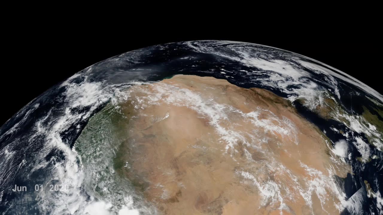
Godzilla Dust Strom। Nasa
In June 2020, a "Godzilla" dust plume travelled from the Sahara, the planet’s largest, hottest desert, across the Atlantic ocean to North America. Saharan dust plumes are a natural phenomenon and occur especially during the summertime, due to dust uplift from low level jets and haboobs. This particular event was nicknamed "Godzilla" dust plume, because of its huge extent and massive amount of dust transport - the most intense episode over the past two decades.
The data visualizations included on this webpage track the "Godzilla" dust plume by featuring near real-time VIIRS Corrected Reflectance (True Color) daily imagery for the month of June 2020. The first visualization listed on this webpage showcases the trans-Atlantic transport of the dust plume, while the second visualization showcases the formation of the dust plume as seen from West Africa.
The Sahara Desert is 3,600,000 square miles (9,200,000 square kilometers) of arid land stretched across the northern half of Africa, coming in just slightly smaller in size than the continental United States. Upwards of 60 million tons of its nutrient-laden sand and soil are lifted into the atmosphere each year, creating a massive layer of hot, dusty air that winds carry across the Atlantic to deliver those nutrients to the ocean and vegetation in South America and the Caribbean.
On its journey across the Atlantic, Saharan dust sprinkles into the ocean, feeding the marine life, and similarly plant life once it makes landfall. Minerals like iron and phosphorus in the dust act as a fertilizer for the Amazon rainforest, Earth’s largest and most biodiverse tropical forest, whose rains otherwise wash many of these valuable nutrients into the Amazon river basin.
Tracking and understanding dust plumes and their effects is critical, since dust intrusion also affects air quality. The “Godzilla” dust plume degraded the air quality in the Carribean Basin to the hazardous level and the dust intrusion into the U.S. exceeded the EPA air quality in about 40% of the stations in Southern U.S. Breathing in dust is particularly hazardous for children, the elderly, and those with respiratory conditions like asthma. Because of this, the Moderate Resolution Imaging Spectroradiometers (MODIS) on NASA's Terra and Aqua satellites, the National Oceanic and Atmospheric Administration (NOAA) GOES-16 (EAST) satellite, and the Visible Infrared Imaging Radiometer Suite (VIIRS) on the joint NASA/NOAA Suomi NPP satellite are employed to help detect dust plumes, so that at-risk communities could prepare for the potentially adverse health effects.
-
 2:37:49
The Connect: With Johnny Mitchell
1 day ago $6.88 earnedBlackwater Mercenary EXPOSES Private Military War Secrets From The Middle East, Fueling Terrorism
31.4K33 -
 2:54:21
Total Horse Channel
2 days ago2025 Scottsdale Arabian Horse Show | Saturday Evening Session
67K6 -
 22:39
22:39
The Mel K Show
9 hours agoMel K & Representative Brandon Gill | Our Constitutional Republic is Being Restored | 4-26-25
55.6K46 -
 4:17:17
VapinGamers
9 hours ago $4.22 earned📣 Fortnite Family Night! - Games and Dubs with BrianZGame - !rumbot
44.1K3 -
 4:27:48
ThePope_Live
7 hours agoLIVE - First time playing The Finals in over a YEAR! Still good? with @Arrowthorn
34K1 -
 3:06:26
TruthStream with Joe and Scott
13 hours agoRoundtable with Patriot Underground and News Treason Live 4/26 5pm pacific 8pm Eastern
50.9K34 -
 8:52
8:52
Tundra Tactical
11 hours ago $9.72 earnedSCOTUS Denies Appeal, Minnesota Courts Deal 2a Win!
51.7K11 -
 10:36:01
a12cat34dog
12 hours agoONE WITH THE DARK & SHADOWS :: The Elder Scrolls IV: Oblivion Remastered :: FIRST-TIME PLAYING {18+}
77K6 -
 22:27
22:27
Exploring With Nug
19 hours ago $12.83 earnedSwamp Yields a Chilling Discovery in 40-Year Search for Missing Man!
64.5K17 -
 1:23:26
RiftTV/Slightly Offensive
14 hours ago $12.20 earnedThe LUCRATIVE Side of Programming and the SECRETS of the "Tech Right" | Guest: Hunter Isaacson
70.7K36