Premium Only Content

An examination of the satellite images from the Koniko gas field (the largest gas field in Syria)
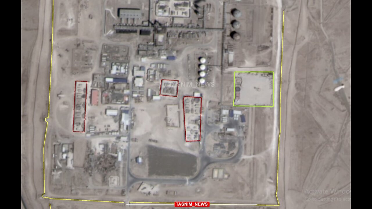
An examination of the satellite images released from the Koniko gas field (the largest gas field in Syria) shows that the US Army is heavily engaged in new constructions in this area.
According to what can be seen in the satellite images, since about 2 years ago, the construction of numerous military facilities in the Koniko gas field has been increasing, including the construction of a defensive wall (4 km) around this area. He also mentioned the creation of numerous bunkers and military sites in the northern and central part of this gas field.
In addition, since the beginning of last year (2022), a monitoring balloon management center has been established in this gas field, which monitors the area from a height of 4,000 meters above the ground. (Recent satellite images are at the moment the balloon was photographed at a height of 1,200 meters above the ground.)
Based on satellite images, it seems that 6 military sites have been created within the 100-hectare area of Koniko Square, and their location and arrangement changes from time to time.
According to the information received by Tasnim, private American companies, as operators of remote sensing satellites, take pictures of this area almost permanently and at least once a week.
-
 54:18
54:18
Candace Show Podcast
7 hours agoHarvey Speaks: Jessica Mann & The Five Year Affair | Ep 3
138K36 -
 56:53
56:53
Grant Stinchfield
6 hours ago $5.38 earnedFreeze Spending & Kick the Can Down the Road... Why Republicans Should do Just That!
69.2K10 -
 56:48
56:48
VSiNLive
6 hours agoFollow the Money with Mitch Moss & Pauly Howard | Hour 1
58.1K -
 3:28:27
Barry Cunningham
7 hours agoTRUMP DAILY BRIEFING: INTERNET UNDER ATTACK! X & RUMBLE DOWN! EXECUTIVE ORDER SIGNING!
81.3K40 -
 5:53:56
Scammer Payback
11 hours agoCalling Scammers Live
71.3K5 -
 1:36:15
In The Litter Box w/ Jewels & Catturd
1 day agoABOLISH NGOs | In the Litter Box w/ Jewels & Catturd – Ep. 758 – 3/10/2025
92.5K56 -
 2:04:36
Film Threat
1 day agoVERSUS: DAREDEVIL: BORN AGAIN + MICKEY 17 + THE STATE OF SCI-FI | Film Threat Versus
40.7K -
 1:21:46
The HotSeat
7 hours agoIt's A Trap America! Do Not Fall For It!
30.9K19 -
 1:26:22
The Quartering
9 hours agoTrump In Dubai, Democrats BUSTED Funding Attacks On Tesla, DOGE Covid BOMBSHELL & Bernie Sanders
88.9K79 -
 1:39:57
Russell Brand
11 hours agoTYRANNY In Europe as Romanian Right-Wing Presidential Frontrunner BANNED from Elections – SF550
158K47