Earth At Night
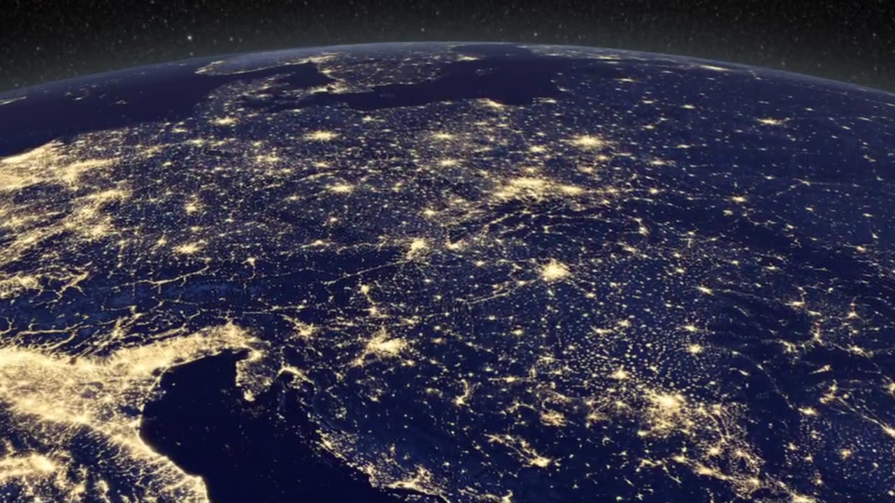
In daylight our big blue marble is all land, oceans and clouds. But the night - is electric. This view of Earth at night is a cloud-free view from space as acquired by the Suomi National Polar-orbiting Partnership Satellite (Suomi NPP). A joint program by NASA and NOAA, Suomi NPP captured this nighttime image by the satellite's Visible Infrared Imaging Radiometer Suite (VIIRS). The day-night band on VIIRS detects light in a range of wavelengths from green to near infrared and uses filtering techniques to observe signals such as city lights, gas flares, and wildfires. This new image is a composite of data acquired over nine days in April and thirteen days in October 2012. It took 312 satellite orbits and 2.5 terabytes of data to get a clear shot of every parcel of land surface. This video uses the Earth at night view created by NASA's Earth Observatory with data processed by NOAA's National Geophysical Data Center and combined with a version of the Earth Observatory's Blue Marble: Next Generation. Released Wednesday, December 5th, 2012 This video is public domain and along with other supporting visualizations can be downloaded from the Scientific Visualization Studio at: http://svs.gsfc.nasa.gov/13425 Credit: NASA's Goddard Space Flight Center/Kayvon Sharghi/Mike Carlowicz If you liked this video, subscribe to the NASA Goddard YouTube channel: http://www.youtube.com/NASAExplorer Follow NASA’s Goddard Space Flight Center • Instagram http://www.instagram.com/nasagoddard • Twitter http://twitter.com/NASAGoddard • Twitter http://twitter.com/NASAGoddardPix • Facebook: http://www.facebook.com/NASA.GSFC • Flickr http://www.flickr.com/photos/gsfc
-
 54:59
54:59
Stephen Gardner
3 hours ago🔥Biden insider: Obama was Pulling Strings | Trump Derangement is RAGING!
20.8K117 -
 4:52:51
LFA TV
1 day agoLFA TV SHORT CLIPS OF THE WEEK!
26.7K6 -
 4:12:52
Pepkilla
4 hours agoAI has taken over come with me if you want to live
19.7K2 -
 UPCOMING
Vedic compatability astrology
4 hours agoDiscover Wisdom from Dr Andrew Dutta
4 -
 8:13:39
Grant Cardone
9 hours ago10X Business Summit Day 2
75.9K1 -
 1:51:26
SternAmerican
5 hours agoElection Integrity Town Hall - Lee County with Raj Doraisamy of Defend Florida 2:00pm Est
27.9K2 -
 12:01
12:01
T-SPLY
8 hours agoBREAKING - Jasmine Crockett Under Investigation For Fraudulent Campaign Donations
15.9K28 -
 39:07
39:07
Steph & Kayls
6 hours agoFrom Spicy Content to Sleepless Nights: The Chaos of Being First-Time Parents & Creators | Ep. 1
10.8K4 -
 1:36
1:36
Nick Shirley
8 hours ago $1.64 earnedThese Anti-Trump and Elon Protesters are Idiots
17.4K38 -
 17:08
17:08
World2Briggs
1 day ago $0.79 earned10 Worst Cities to Move if You Hate Yourself.
12.4K6