Premium Only Content

Animated Flyover of Pluto’s Icy Mountain and Plains
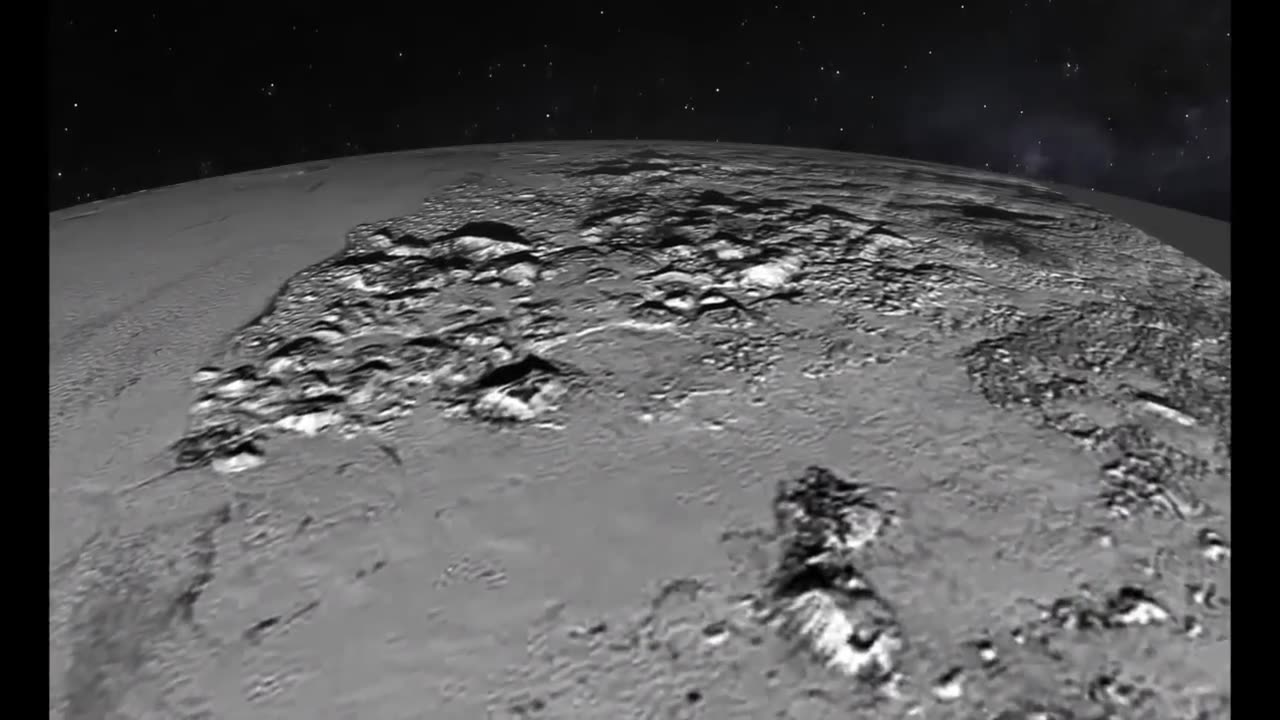
This simulated flyover of Pluto’s Norgay Montes (Norgay Mountains) and Sputnik Planum (Sputnik Plain) was created from New Horizons closest-approach images. Norgay Montes have been informally named for Tenzing Norgay, one of the first two humans to reach the summit of Mount Everest. Sputnik Planum is informally named for Earth’s first artificial satellite. The images were acquired by the Long Range Reconnaissance Imager (LORRI) on July 14 from a distance of 48,000 miles (77,000 kilometers). Features as small as a half-mile (1 kilometer) across are visible.
This simulated flyover of Pluto’s Norgay Montes (Norgay Mountains) and Sputnik Planum (Sputnik Plain) was created from New Horizons closest-approach images. Norgay Montes have been informally named for Tenzing Norgay, one of the first two humans to reach the summit of Mount Everest. Sputnik Planum is informally named for Earth’s first artificial satellite. The images were acquired by the Long Range Reconnaissance Imager (LORRI) on July 14 from a distance of 48,000 miles (77,000 kilometers). Features as small as a half-mile (1 kilometer) across are visible.
This simulated flyover of Pluto’s Norgay Montes (Norgay Mountains) and Sputnik Planum (Sputnik Plain) was created from New Horizons closest-approach images. Norgay Montes have been informally named for Tenzing Norgay, one of the first two humans to reach the summit of Mount Everest. Sputnik Planum is informally named for Earth’s first artificial satellite. The images were acquired by the Long Range Reconnaissance Imager (LORRI) on July 14 from a distance of 48,000 miles (77,000 kilometers). Features as small as a half-mile (1 kilometer) across are visible.
This simulated flyover of Pluto’s Norgay Montes (Norgay Mountains) and Sputnik Planum (Sputnik Plain) was created from New Horizons closest-approach images. Norgay Montes have been informally named for Tenzing Norgay, one of the first two humans to reach the summit of Mount Everest. Sputnik Planum is informally named for Earth’s first artificial satellite. The images were acquired by the Long Range Reconnaissance Imager (LORRI) on July 14 from a distance of 48,000 miles (77,000 kilometers). Features as small as a half-mile (1 kilometer) across are visible.
This simulated flyover of Pluto’s Norgay Montes (Norgay Mountains) and Sputnik Planum (Sputnik Plain) was created from New Horizons closest-approach images. Norgay Montes have been informally named for Tenzing Norgay, one of the first two humans to reach the summit of Mount Everest. Sputnik Planum is informally named for Earth’s first artificial satellite. The images were acquired by the Long Range Reconnaissance Imager (LORRI) on July 14 from a distance of 48,000 miles (77,000 kilometers). Features as small as a half-mile (1 kilometer) across are visible.
This simulated flyover of Pluto’s Norgay Montes (Norgay Mountains) and Sputnik Planum (Sputnik Plain) was created from New Horizons closest-approach images. Norgay Montes have been informally named for Tenzing Norgay, one of the first two humans to reach the summit of Mount Everest. Sputnik Planum is informally named for Earth’s first artificial satellite. The images were acquired by the Long Range Reconnaissance Imager (LORRI) on July 14 from a distance of 48,000 miles (77,000 kilometers). Features as small as a half-mile (1 kilometer) across are visible.
This simulated flyover of Pluto’s Norgay Montes (Norgay Mountains) and Sputnik Planum (Sputnik Plain) was created from New Horizons closest-approach images. Norgay Montes have been informally named for Tenzing Norgay, one of the first two humans to reach the summit of Mount Everest. Sputnik Planum is informally named for Earth’s first artificial satellite. The images were acquired by the Long Range Reconnaissance Imager (LORRI) on July 14 from a distance of 48,000 miles (77,000 kilometers). Features as small as a half-mile (1 kilometer) across are visible.
-
 LIVE
LIVE
Candace Show Podcast
1 hour agoBlake Lively's BOMBSHELL Legal Filing | Candace Ep 149
6,229 watching -
 1:41:00
Darkhorse Podcast
3 hours agoIf Only We’d Known: The 265th Evolutionary Lens with Bret Weinstein and Heather Heying
31.8K20 -
 DVR
DVR
Vigilant News Network
4 hours agoElon Musk Shuts Down RFK Jr. Critics With One Powerful Statement | The Daily Dose
8.45K2 -
 1:01:21
In The Litter Box w/ Jewels & Catturd
20 hours agoI've Got Your Proof - Right Here! | In the Litter Box w/ Jewels & Catturd – Ep. 745 – 2/19/2025
32.7K19 -
 2:14:30
FreshandFit
4 hours agoDavid Icke On COVID Lies, Censorship, Secret Societies, Infiltration of MAGA, AI Control, Alternative Media Subversion And MORE!
51.7K18 -
 1:41:41
The Quartering
6 hours agoTrump's New IVF Order, GameStop CEO Denounces Wokeness Amid Sale, and Elon Musk's DOGE Role Revealed
78.9K37 -
 LIVE
LIVE
Dr Disrespect
5 hours ago🔴LIVE - DR DISRESPECT - TARKOV - ZERO TO HERO PISTOL ONLY
2,823 watching -
 LIVE
LIVE
Film Threat
7 hours agoCRISIS ON MULTIPLE MARVEL MOVIES! | Hollywood on the Rocks
109 watching -
 49:19
49:19
Miss Understood With Rachel Uchitel
1 day agoKris Krohn: The Real Estate Playbook for Financial Freedom
31.6K3 -
 15:24
15:24
Bearing
8 hours ago"N*ZI GERMANY HAD TOO MUCH FREE SPEECH" - Brain Dead CBS Anchor Gets SCHOOLED 😂
4.3K30