Premium Only Content

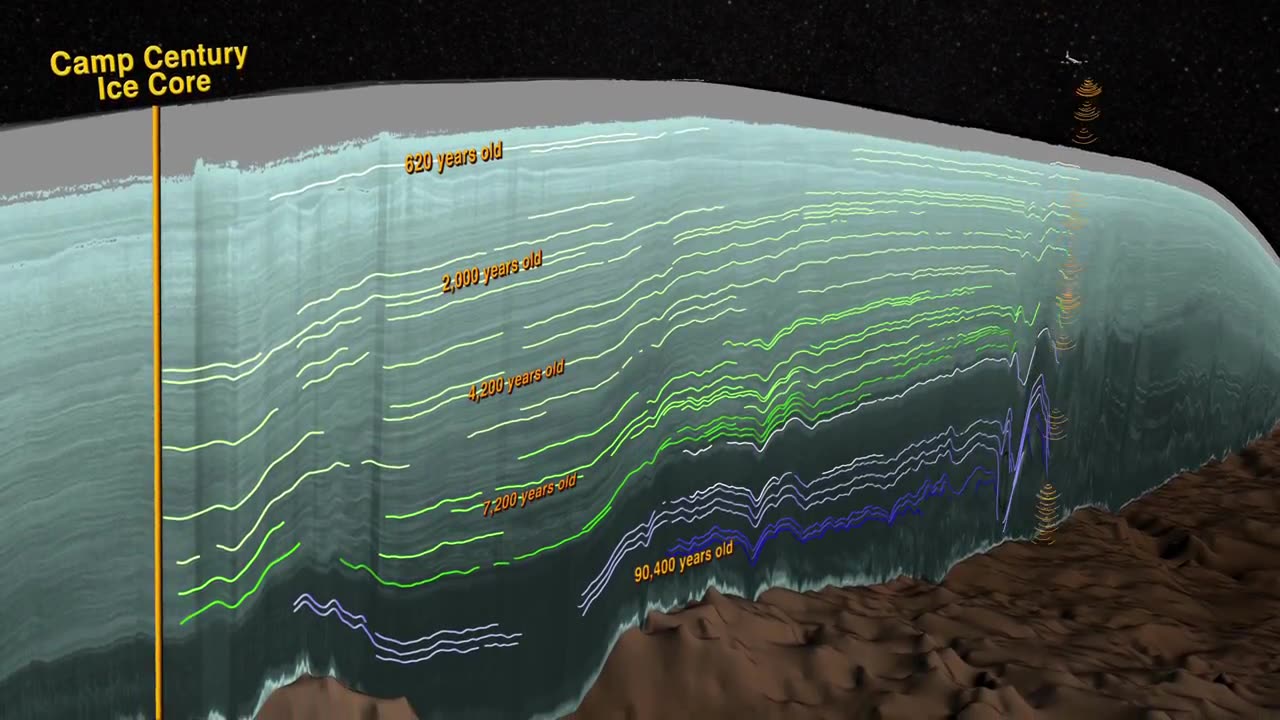
NASA | Greenland's Ice Layers Mapped in 3D
http://www.nasa.gov/content/goddard/icebridge/nasa-data-peers-into-green... Peering into the thousands of frozen layers inside Greenland’s ice sheet is like looking back in time. Each layer provides a record of not only snowfall and melting events, but what the Earth’s climate was like at the dawn of civilization, or during the last ice age, or during an ancient period of warmth similar to the one we are experiencing today. Using radar data from NASA’s Operation IceBridge, scientists have built the first-ever comprehensive map of the layers deep inside the ice sheet. This video is public domain and can be downloaded at: http://svs.gsfc.nasa.gov/goto?4249 Like our videos? Subscribe to NASA's Goddard Shorts HD podcast: http://svs.gsfc.nasa.gov/vis/iTunes/f0004_index.html Or find NASA Goddard Space Flight Center on facebook: http://www.facebook.com/NASA.GSFC Or find us on Twitter: http://twitter.com/NASAGoddard
-
 33:41
33:41
PMG
11 hours ago $0.75 earnedHannah Faulkner and Haile McAnally | OMAHA YR RACE
7.19K3 -
 21:24
21:24
The Based Mother
1 day ago $1.46 earnedThis is not a drill - California is set on self-destruction.
7.96K7 -
 6:06:49
Sgt Wilky Plays
14 hours agoFirefight Friday
63K6 -
 5:03:49
Drew Hernandez
17 hours agoLA MAYOR PUSHED $49 MILL LAFD BUDGET CUT ONE WEEK BEFORE FIRES?
119K72 -
 2:52:04
Nobodies Gaming
13 hours ago $6.68 earnedNobodies Rumble Gaming TEST STREAM 2.0
73.6K3 -
 1:00:36
Talk Nerdy 2 Us
12 hours agoDigital Surveillance, TikTok Shutdowns & The Hackers They Don’t Want You to Know About!
59.7K2 -
 3:08:37
SpartakusLIVE
14 hours agoDelta Force || Tactical, Strategic, HARDCORE
62.7K2 -
 3:32:05
I_Came_With_Fire_Podcast
18 hours agoTRUMP GUILTY Verdict, LA Fires, New American EXPANSIONISM, and Cyber Truck Updates!!
38.1K16 -
 1:26:05
Glenn Greenwald
15 hours agoGOP Senators Demand Tulsi Support Domestic Surveillance To Be Confirmed; Group Tracks IDF War Criminals Around The World; System Pupdate: Pointer's Determination To Survive | SYSTEM UPDATE #387
151K145 -
 57:27
57:27
Flyover Conservatives
1 day agoHealthy People Are Ungovernable: The Secrets They Don’t Want YOU to Know - Tracy Beanz | FOC Show
81.8K7