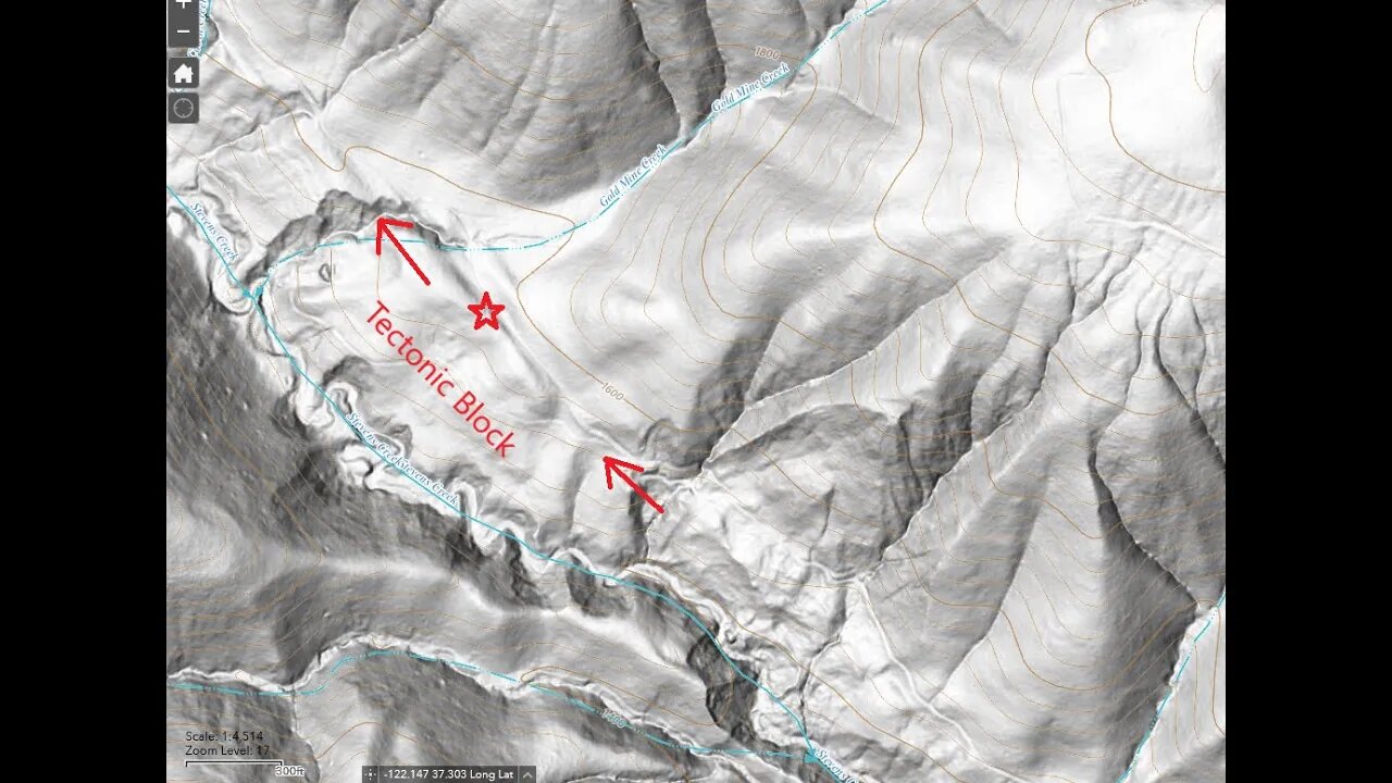
Gold Mine Creek - Tectonic Block
Looking at the tectonic block that sits between the historic and Quaternary traces of the San Andrea fault near Gold Mine Creek.
The hill shade maps really help to show the land forms, especially when combined with the USGS fault maps on Google Earth.
Paper: ENVIRONMENTAL GEOLOGIC ANALYSIS OF THE MONTEBELLO RIDGE MOUNTAIN STUDY AREA:
https://babel.hathitrust.org/cgi/pt?id=mdp.39015042059330&seq=38
"TECTONIC BLOCKS - Large angular to rounded, commonly elliptically shaped masses of relatively hard rocks surrounded by a clay-rich. sheared matrix. Occurs within shear zones and fault gouge. In the shear zones of the Franciscan' rocks, these' blocks range from fist size to masses more than one mile long."
USGS National Map Viewer w/ Hill Shade:
https://apps.nationalmap.gov/viewer/
USGS Quaternary Faults data:
https://earthquake.usgs.gov/education/geologicmaps/qfaults.php
Download the "qfaults.kmz" file from the link on the page, then import that into Google Earth.
Tip: Zoom into your area of interest BEFORE turning on one of the layers. I recall this file has the fault traces, landslide areas and geologic units for a large area and it'll bring your device to a crawl if you enable one of these layers zoomed way out.
You can see how the Canyon Trail, that's mostly built on an old ranch road, follows the historic trace of the San Andreas fault.
If you check out this previous video:
https://youtu.be/_7jxPb-Cvmw?t=366
You can see what this area looked like prior to the road being built.
Montebello Open Space history page:
https://www.openspace.org/preserves/monte-bello#history
More to come...
Subscribe for more content like this
Comment, rate, share & click the bell icon
And as always, thanks for watching
#USGS #HillShade
-
 LIVE
LIVE
Steven Crowder
1 hour ago🔴 Doge's Big Secret & Trump Slaps Commies and Illegals
50,438 watching -
 1:02:52
VINCE
2 hours agoTulsi Just Found The Classified Election Rigging Files | Episode 20 - 04/11/25
80.9K81 -
 LIVE
LIVE
The Rubin Report
2 hours agoWill Trump’s New Escalation in Trade War with China Backfire?
876 watching -
 LIVE
LIVE
Benny Johnson
16 minutes ago🚨 Director of National Intelligence Reveals EVIDENCE of Rigged 2020 Election, Machines Switch Votes
2,248 watching -
 LIVE
LIVE
LFA TV
4 hours agoLFA TV - ALL DAY LIVE STREAM 4/11/25
2,210 watching -
 LIVE
LIVE
Canada Strong and Free Network
3 hours agoCanada Strong and Free Network
197 watching -
 LIVE
LIVE
Caleb Hammer
21 minutes agoShe’s Hiding $330,000 Debt From Overseas Husband | Financial Audit
119 watching -
 1:00:01
BonginoReport
5 hours agoFighting the Red Dragon: Evita + Natalie Winters - BR Early Edition w/ Evita (Ep.180)
103K51 -
![🔴[LIVE] China Retaliates, Breaking Inflation News & Payday Friday || The MK Show](https://1a-1791.com/video/fww1/2d/s8/1/R/r/a/B/RraBy.0kob.1-small-LIVE-China-Retaliates-Break.jpg) LIVE
LIVE
Matt Kohrs
10 hours ago🔴[LIVE] China Retaliates, Breaking Inflation News & Payday Friday || The MK Show
1,054 watching -
 LIVE
LIVE
Wendy Bell Radio
6 hours agoAll The President's Men
9,651 watching