Premium Only Content

Stevens Creek Landslide Lake Level Visualization
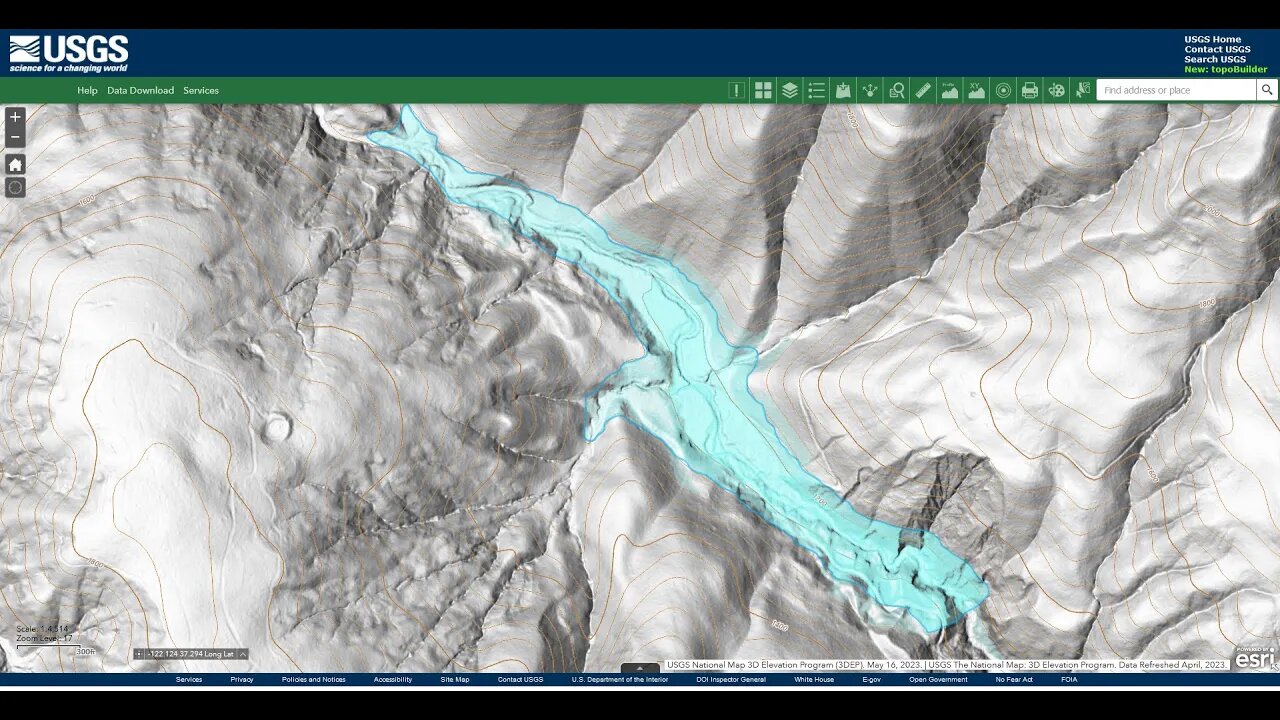
Going by GPS elevation data (1236 ft.), it appears that the landslide lake may have backed up about 1 km above the landslide to where the modern Lower Table Mountain trail starts.
I traced the 1240 foot contour line and filled in that area in a transparent blue color to generate this view of a possible high water point:
https://photos.app.goo.gl/rdm2LovcWbE4EhZw6
Volume estimation:
3000' long x 100' avg.width x 40' avg.depth / 42,000 ft^2/acre = 285 acre-feet or ~351,000 m^3.
This area is where traces of the 1895 road show up. There also seem to be large sediment bars on both sides of the creek where the trail crosses Stevens Creek. The 1895 road seems to have taken advantage of the relatively flat lake deposits between these 2 water crossings. However, the flood and subsequent erosion after the 1906 earthquake and landslide is likely what wiped out a good portion of that old road between the 2 creek crossings.
Stevens Creek flow information:
https://alert.valleywater.org/map?p=sensor&sid=5045&disc=f
This is my hypothesis for what has happened in this section of Stevens Creek to explain the flat nature and deep sediment here. Also ties in the anecdotal evidence from the 1973 geology paper:
ENVIRONMENTAL GEOLOGIC ANALYSIS OF THE MONTEBELLO RIDGE MOUNTAIN STUDY AREA:
https://openlibrary.org/works/OL68916...
Pg. 22 mentions a landslide associated with the 1906 earthquake and this is ground zero for that slide. In fact, the report mentions that slide extended for 1/2 mile, nearly a kilometer, along the canyon.
USGS National Map Viewer w/ Hill Shade layers:
https://apps.nationalmap.gov/viewer/
More to come...
Subscribe for more content like this
Comment, rate, share & click the bell icon
And as always, thanks for watching
#USGS #HillShade #geology #earthquake #tectonicplates
-
 DVR
DVR
Simply Bitcoin
2 hours ago $0.37 earnedNEW REPORT: Bitcoin ETF Insider Doubles Down on UNTHINKABLE 2030 prediction! | EP 1176
6.68K -
 LIVE
LIVE
The Dana Show with Dana Loesch
1 hour agoTRUMP PLANS TO TAKE OVER GAZA | The Dana Show LIVE On Rumble!
674 watching -
 59:36
59:36
The Dan Bongino Show
4 hours agoTrump Shocks The World With Major Announcement (Ep. 2416) - 02/05/2025
624K987 -
 1:19:04
The Rubin Report
3 hours agoTrump & Netanyahu Shock with Truly Unexpected Plan for Gaza
63.5K62 -
 1:59:23
Steven Crowder
5 hours ago🔴 Trump's Hitlist Grows: USAID, Dept. of Education, CIA, and... Gaza?
385K335 -
 57:49
57:49
Grant Stinchfield
2 hours ago $1.53 earnedThe FBI Withholds 5000 Names of Agents & Employees Who Hunted Down J6'ers
9.05K4 -
 2:02:40
LFA TV
17 hours agoMA-GAZA STRIP! | LIVE FROM AMERICA 2.5.25 11am
55.1K13 -
 2:14:55
Matt Kohrs
11 hours agoBreaking Market News, Earnings Review & Live Trading $1M || The MK Show
81.8K1 -
 1:27:18
Caleb Hammer
3 hours agoRadical Femcel Is Literal Garbage | Financial Audit
26K1 -
 38:57
38:57
Rethinking the Dollar
3 hours agoEvery Signature Counts: How Trump's Policies Threaten the Dollar's Stability
43.9K5