Premium Only Content

Comb Ridge Wash Trail - Bears Ears National Monument
Comb Ridge
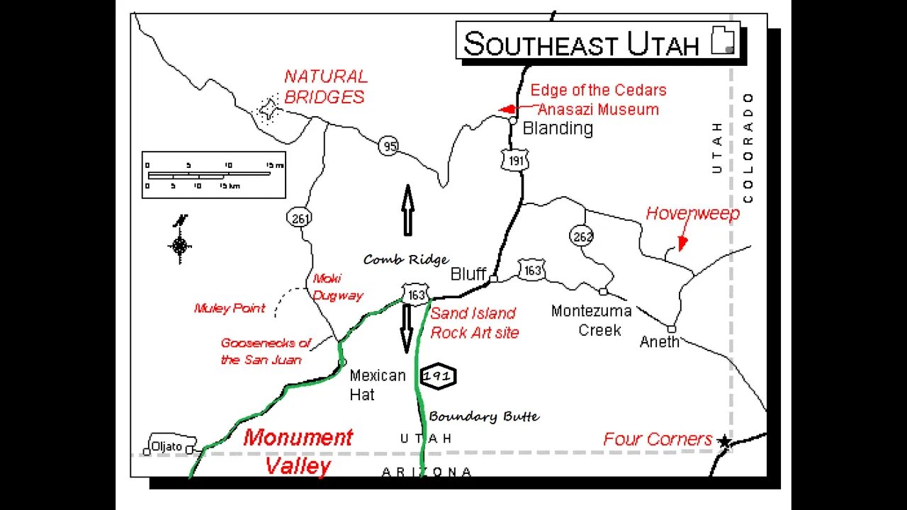
Just a few miles west of Bluff is Comb Ridge, a steep ridge running 80 miles in a north/south direction from Kayenta, Arizona to the foothills of the Abajo Mountains near Blanding, Utah. Tilted at almost 20 degrees and over one mile wide, the name comes from the jagged appearance of the ridge which is similar in shape to a rooster’s comb.
This natural marvel is a classic example of what geologists call a monocline, or a step-like bend of the earth’s rock layers in one direction. This blunt rock extension occurred nearly 65 million years ago, when tectonic plates buried deep under the earth’s surface slipped, leaving a rugged scar across once smooth stone.
Comb Ridge is now protected and form the major part of the Shash Jaa Unit of Bears Ears National Monument.
History
Archaeological surveys of the Ridge have revealed more of the formation’s ancient secrets, from Ice Age camps and 800-year-old Ancestral Puebloan cliff dwellings, to historic artifacts of Anglo settlers, and strange lanes carved into the earth across miles of desert. These are Ancestral Puebloan roads and “Anasazi roads” are believed to connect places of significance.
In 1880, Mormon pioneers on the last leg of their grueling Hole-in-the-Rock trek crossed the structure before settling Bluff. Knowing Comb Ridge was a formidable obstacle, they traveled south along the Comb to the San Juan River. There they built another dugway up the face of Comb Ridge naming it “San Juan Hill”.
Comb Ridge Exploring
Ancestral Puebloans once found refuge in the Comb’s alcoves. Vacationers wishing to explore the rich archeological aspects of the Comb can discover traces of the ancient Ancestral Puebloan culture via ruins and rock art on the canvas of cave walls. Each cleft in Comb Ridge indicates a small canyon created by flash floods that can be accessed from behind the ancient stretch of rock formation.
As you drive west from Bluff on Highway 163, you will cross the Ridge. Two, parallel gravel roads run north/south on either side of Comb Ridge: Comb Wash (County Road 235) to the west of Comb Ridge and Butler Wash (County Road 230) to the east. The roads link to Highway 95 on the north.
Butler Wash has entrances to numerous, short, box canyons which contain rock art and ruins. North of Highway 95 are the Butler Wash Ruins overlook. This is a cliff dwelling built and occupied by Ancestral Puebloans around 1200. Parts of the site have been stabilized and reconstructed. Round trip hiking distance is about 1 mile. Parking and a restroom are available.
Visit With Respect
Comb Ridge is part of the Bears Ears National Monument and, as such,dwelling remains and rock art are extremely fragile and are of important cultural significance. To preserve this important landscape for future generations, visitors should refrain from touching rock art or moving artifacts. Before you go, check out the "Visit with Respect" tips offered by blogger, Erica Tucker.
General Information
Fees: A permit is required from the Bureau of Land Management for hiking for day use and overnight backpacking in Butler Wash. Day use permits (except for Moon House) are available at self-pay locations at some trailheads but a better plan is to obtain a permit for all of Cedar Mesa through https://www.recreation.gov/ and go to the “My Reservation” section. I purchased an annual pass for “Cedar Mesa & Comb Ridge Day Hiking”. It cost me, as of May 2023, $44.50 and is good to the end of May 2024.
Camping: Just south of Highway 95 on Butler Wash is the Comb Wash Campground which features dispersed camping and pit toilets. No water is available. Dispersed camping is also allowed along Comb Wash and Butler Wash. You must stay on previously disturbed areas within 150 feet of designated routes and should not drive off road to create a new campsite. Please do not camp inside ruins. Plan on bringing your own water and to pack out your trash and waste.
BLM Website Links: https://www.blm.gov/programs/recreation/permits-and-passes/lotteries-and-permit-systems/utah/cedarmesa
www.blm.gov/sites/blm.gov/files/documents/files/River%20House%20Ruin.pdf
YouTube video showing the River House Ruins: https://youtu.be/80l98-ukBEQ
Hole-in-the-Rock Trek Remains an Epic Experience in Pioneering
https://historytogo.utah.gov/hole-rock-trek/
Thanks for watching and viewing our channel. It is sincerely appreciated.
Cactus Hill
-
 LIVE
LIVE
Dr Disrespect
4 hours ago🔴LIVE - DR DISRESPECT - WARZONE - CRAZY CHALLENGES
4,088 watching -
 LIVE
LIVE
China Uncensored
1 hour agoCan Anything Stop the Tiktok Ban?
153 watching -
 7:08
7:08
Guns & Gadgets 2nd Amendment News
5 hours agoTruckers Fight For National Reciprocity
1.08K3 -
 LIVE
LIVE
Scammer Payback
1 hour agoCalling Scammers Live
433 watching -
 DVR
DVR
Stephen Gardner
1 hour ago🔥Congress DROPS Bad News on Newsom and Biden!
2.7K1 -
 LIVE
LIVE
Twins Pod
1 hour agoHe Left The RAP Industry To Make Christian Music! | Twins Pod - Episode 48 - Bryson Gray
1,553 watching -
 1:30:05
The Quartering
3 hours agoSupreme Court RULES On TikTok Ban, Kamala Harris At Rock Bottom & Brawls Break Out At Costco!
37.7K10 -
 1:36:11
Tucker Carlson
3 hours agoSean Davis: Trump Shooting Update, & the Real Reason Congress Refuses to Investigate
140K67 -
 2:55:32
The Dana Show with Dana Loesch
4 hours agoTHE END OF TIKTOK | The Dana Show LIVE On Rumble!
7.62K5 -
 1:22:57
The Criminal Connection Podcast
4 hours ago $0.19 earnedPADDY DOHERTY: Dougie Joyce RESPONSE! Bare Knuckle Fighting, Sausage Fests & Assassination Attempts
6.15K