Premium Only Content

Drone Captures Slackliner's Incredible Valley Crossing
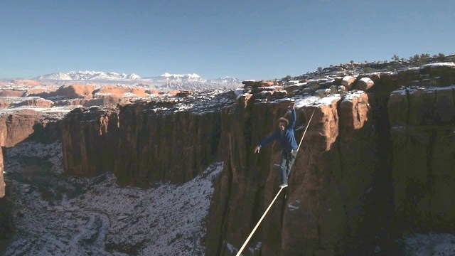
The Moab desert forms a breathtaking backdrop to a slack liner's nail-biting valley crossing 400ft in the air.
Using a camera attached to a drone, a team from SkySight Aerial Imaging was able to film the daredevil walk in 360 degrees. Thrill-seekers Andy Lewis and Scott Roger scaled towering rock monuments to make the 70ft crossing - and were treated to unparalleled aerial views of the snowcapped Utah landscape.
The Biblical name Moab refers to an area of land located on the eastern side of the Jordan River. Some historians believe the city in Utah came to use this name because of William Pierce, the first postmaster, believing that the biblical Moab and this part of Utah were both "the far country". However, others believe the name has Paiute origins, referring to the word moapa, meaning "mosquito".
Moab is famous for canyoneering, hiking, river rafting, biking, motorcycling, ATV riding, and 4x4 driving. The Moab area is home to many easy to difficult off-road trails for novice to experienced off-roaders. Every year the Moab Munifest, one of the biggest mountain unicycling events in the world, takes place at Moab.
What a stunning view!
-
 59:42
59:42
PMG
4 hours agoManhood in Crisis: What Ancient Rome Can Teach the 21st Century
1.91K -
 LIVE
LIVE
Akademiks
3 hours agoASAP Rocky Case has Begun . He's facing 24 years for SH**ting his friend!
3,452 watching -
 1:58:50
Revenge of the Cis
4 hours agoEpisode 1436: Adios Amigo
13K2 -
 1:14:45
Awaken With JP
5 hours agoTrump's Making Everyone His B*tch LOL - LIES Ep 76
72.7K39 -
 1:41:43
Megyn Kelly
1 day agoMedia's ICE Hoax, Vance's Masterclass on CBS, & Trump vs Bass, w/ Steve Bannon & Batya Ungar-Sargon
68.3K69 -
 1:04:28
In The Litter Box w/ Jewels & Catturd
1 day agoGreen New Scam | In the Litter Box w/ Jewels & Catturd – Ep. 729 – 1/28/2025
88.9K34 -
 2:03:41
The Quartering
6 hours agoTrump To END Income Tax, Captain America Backlash, Obese Rapper Sues Lyft & Surge Pricing In Walmart
95.5K43 -
 1:05
1:05
tether
12 hours agoHadron by Tether - tokenize anything, anywhere
34.9K3 -
 34:32
34:32
Standpoint with Gabe Groisman
21 hours agoGovt. Workers AREN’T Working Says DOGE Chair Sen. Joni Ernst
26.8K9 -
 56:49
56:49
Savanah Hernandez
5 hours agoMASS DEPORTATIONS ARE HERE AND THEY ARE GLORIOUS
42.2K18