Satellites Are Saving Lives In Battle Against Chile's Wildfires
Satellites are saving lives in Chile where wildfires caused by record-hot weather are breaking out in the Southern Hemisphere.
Summer temperatures in the Southern Hemisphere of more than 104 degrees Fahrenheit (40 degrees Celsius) are affecting attempts to combat a massive wildfire outbreak involving at least 231 distinct flames in central Chile.
At least 26 people have been killed, 1,182 have been wounded, 1,100 dwellings have been demolished, and three regions have declared a state of emergency.
These wildfires are burning in three sparsely inhabited central districts - Araucana, Biobo, and Nuble - which are home to many grape, apple, and berry farms, as well as large areas of forest land.
The Nuble area has maintained a preventative early warning system owing to the possibility of forest fires caused by high temperatures since 30th January.
The flames are occurring in the midst of a 13-year-long drought and an extraordinary heat wave in the country's south.
The wildfires have already made 2023 the second worst year in terms of hectares burned, following the so-called "firestorm" that ravaged the nation in 2017.
Twenty-eight of the hundreds of fires have burnt the amount of forest and woodland that the country normally loses in a year.
Temperature forecasts from Santiago to the southern areas have sparked worries about the existing 81 active flames.
Authorities have warned that continued hot and dry weather might aggravate what are already the worst fires in the country's recent history.
Carolina Toha, Chile's interior minister, claimed 76 new flames erupted on 3rd February alone, and that record temperatures were making it impossible to contain the blazes.
"The temperature has reached levels we've never known before," Toha remarked on Saturday.
She also urged that the flames act as a wake-up call to the consequences of the climate disaster. "Chile is one of the countries most vulnerable to climate change, and this is based on genuine experience, not theory."
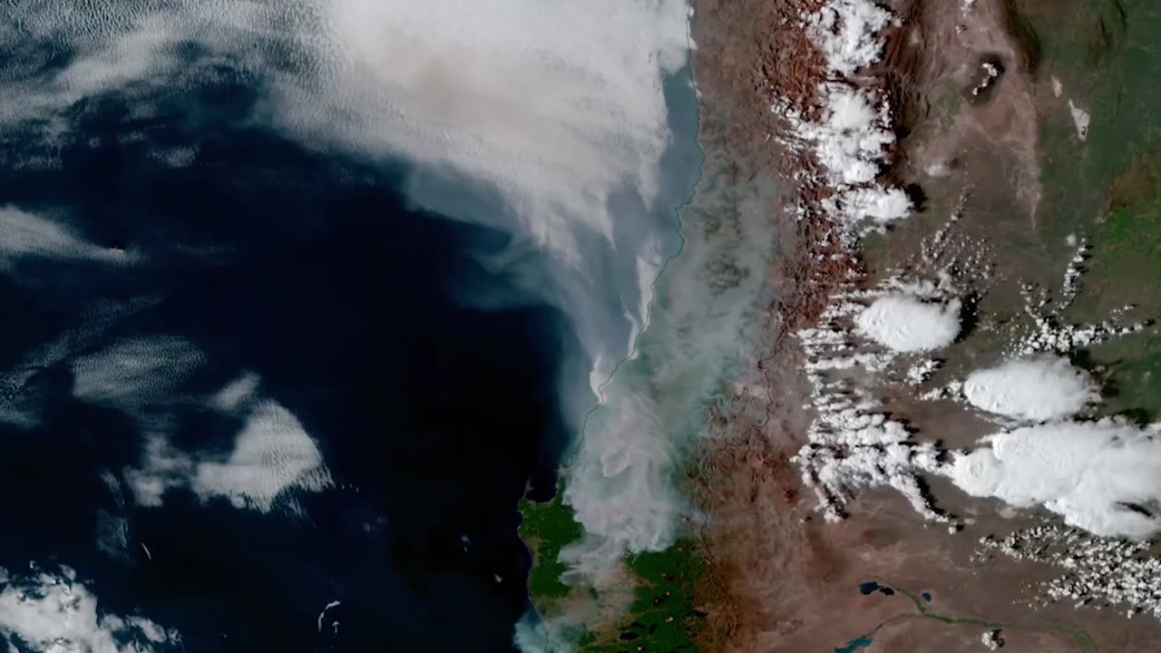
In a dynamic fire environment, NOAA's geostationary satellites offer immediate and potentially life-saving information.
Fires are regularly detected by GOES-16 and GOES-18 before they are seen on the ground, which is especially crucial in isolated places.
The satellites also detect fires in real-time, identify and track smoke, and assist in determining the magnitude and temperature of a fire.
The NOAA-20 and Suomi NPP polar satellites of the Joint Polar Satellite System serve a significant role in identifying and tracking wildfires, particularly in remote areas.
Their high spatial resolution imager identifies smaller, lower-temperature flames and also detects fires at night.
These satellites' data is also crucial for smoke models used by fire departments, first responders, and air traffic controllers.
-
 0:58
0:58
Viral Tab News
1 year ago $0.04 earnedDrug Trafficker Seized In Spain After Decade Under Radar
577 -
 27:24
27:24
Mr. Build It
5 days agoDECK DISASTER! How We Fixed a Botched Build
27.2K10 -
 26:58
26:58
barstoolsports
6 hours agoZach Bryan Blocks All of Barstool | Stool Scenes
19.6K3 -
 1:06:44
Talk Nerdy 2 Us
22 hours ago🔥 Hackers vs. The World: From Amazon breaches to FBI-confirmed Chinese telecom spying
17.6K15 -
 1:24:20
Vigilant News Network
20 hours agoJoe Rogan Drops Shocking Election Claim | The Daily Dose
94.7K83 -
 1:10:18
FamilyFriendlyGaming
19 hours ago $16.49 earnedCat Quest III Episode 2
90.6K1 -
 20:07
20:07
DeVory Darkins
1 day ago $16.73 earned"They Talking About Finance!" The View FRUSTRATED by NYC Mayor TRUTH BOMB
61.9K55 -
 1:20:18
Steve-O's Wild Ride! Podcast
2 days ago $9.46 earnedThe Hawk Tuah Girl Is Really Becoming Successful! - Wild Ride #243
45.5K4 -
 1:29:26
Game On!
20 hours ago $8.76 earnedJon Jones vs Stipe Miocic Heavyweight Title Fight | UFC 309 Preview
46.2K4 -
 30:26
30:26
The Why Files
7 days agoThe Pascagoula UFO Incident | When Nightmares Come True
77.5K60