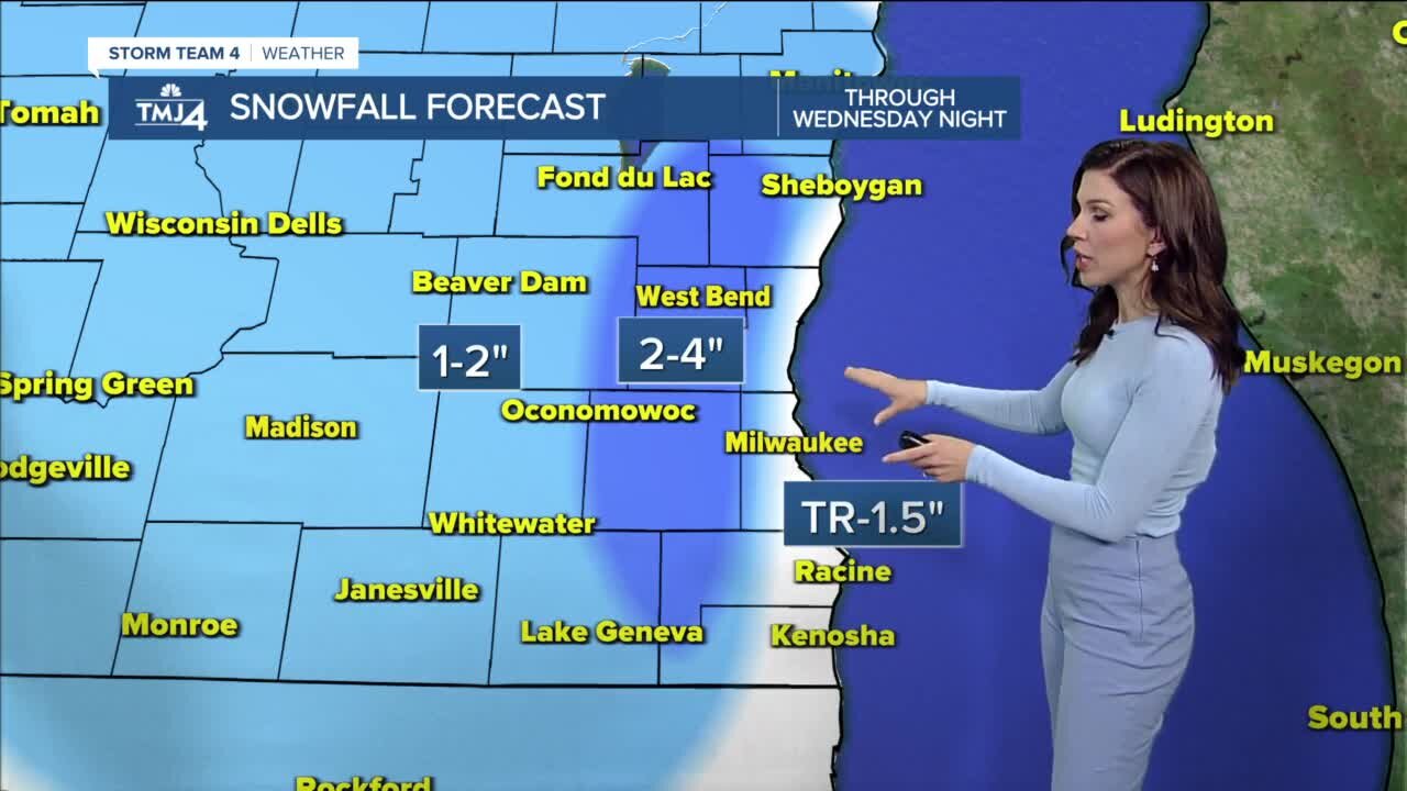
Snowy next few days
Snow showers arrive Tuesday morning and will continue throughout the day. Closer to Lake Michigan will see a rain/snow mix, and potentially just rain at times, as the lake is currently 47° near Milwaukee, 15° above freezing. Isolated snow showers will continue overnight and into Wednesday, with a rain/snow mix by the lake. As the winds shift and colder air moves in from the northwest, we'll switch to light snow showers across the entire area Wednesday night into Thursday. Snowfall will be very light during this time, with <0.5" possible, and taper off from west to east. Temperatures will be chilly Tuesday and Wednesday with highs near 40° and lows in the low 30s. Snowfall accumulation will be 1-2" across southeast Wisconsin. But breaking it down a bit more, by the lakefront where temperatures will be above freezing, we'll see a rain/snow mix, with snowfall accumulation a trace to 1.5", including the city of Milwaukee. Most inland spots can expect 1-2", with higher totals through the Kettle Moraine (eastern Fond du lac, western Sheboygan, Washington, Waukesha, western Racine, and western Kenosha counties) where 2-4" of snow is possible. Colder temperatures move in behind the storm with highs near 30°, lows in the teens, and wind chills in the single digits by the weekend.
-
 1:45
1:45
WTMJMilwaukee
1 year agoProject Drive Safer: How to use metered ramps and HOV lanes in the Milwaukee area
1K -
 1:16:43
Roseanne Barr
4 hours ago $7.53 earnedAnd Gad Saad let there be light | The Roseanne Barr Podcast #96
37.1K17 -
 LIVE
LIVE
Akademiks
4 hours agoDay 9/30. Shannon Sharpe Own Homies Turning They back on him? Uzi Rushed to Hospital? Lil Durk Bond
2,268 watching -
 37:50
37:50
Friday Beers
18 hours ago $0.48 earnedWho Died in Our First Dungeons and Dragons Battle? (Ft. Almost Friday TV)
20.9K2 -
 1:20:16
The HotSeat
2 hours agoCollapse of Common Sense: What the Hell Happened to Minnesota?
25.2K1 -
 11:08
11:08
Talk Nerdy Sports - The Ultimate Sports Betting Podcast
2 hours ago4/24/25 - No One’s Safe: NBA Blowouts, MLB K Bombs, and NHL Kill Shot
17.1K -
 1:04:00
Jeff Ahern
3 hours ago $1.15 earnedThursday thrash with Jeff Ahern!
30.2K1 -
 1:11:52
Russell Brand
5 hours agoThey LIED About 9/11—Now the Truth Is Leaking Out – SF572
153K149 -
 56:46
56:46
Sean Unpaved
5 hours agoNFL Draft Deep Dive: First-Round Movers & Stars to Watch
42.8K -
 54:38
54:38
Ben Shapiro
5 hours agoEp. 2185 - My Journey To Ukraine and My Interview With Zelensky
62.2K55