Stevens Creek Canyon: Above the Landslide
As it exists today, Stevens Canyon Road is paved up to the gate at 1000 ft. elevation. Beyond that, there's limited motor vehicle access along with hiking, biking and equestrian access. About half way to the end, there's a slide area that's taken out the old road, blocking motor vehicle access. The old road continues to the first creek crossing as part of the Canyon Trail.
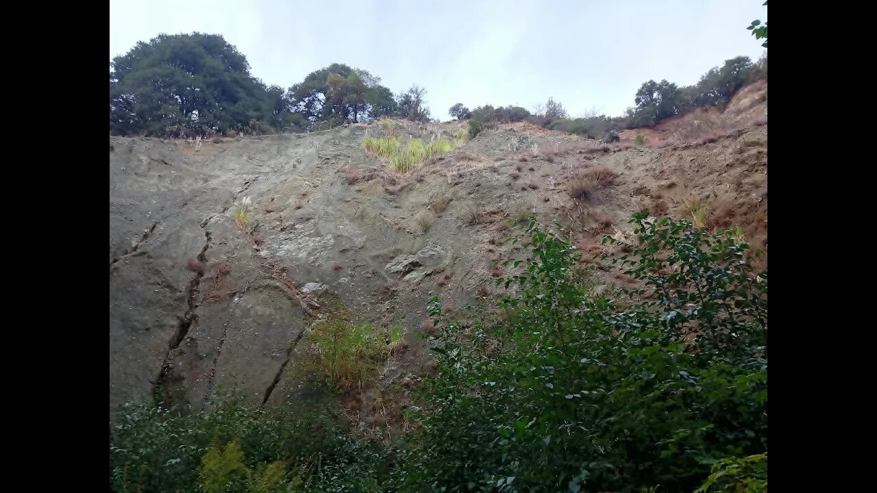
This was a hike downstream from the modern Canyon Trail creek crossing to the area of the landslide that seems to be associated with the San Andreas Fault. This section of the creek canyon is very spectacular and is mostly hidden from view from the road.
Paper: ENVIRONMENTAL GEOLOGIC ANALYSIS OF THE MONTEBELLO RIDGE MOUNTAIN STUDY AREA:
https://openlibrary.org/works/OL6891657W/Environmental_geologic_analysis_of_the_Monte_Bello_Ridge_mountain_study_area_Santa_Clara_County_Cali#editions-list
Pg. 22 mentions a landslide possibly associated with the 1906 earthquake that may be the one visible today.
Future plans are to access the upper wrecked car, possibly this winter. Then next fall, water levels permitting, will try to hike up the canyon from below and try to get to the lower wrecked car and connect up to where I ended this hike.
The "Slide" GeoCache seems to have fallen victim to it's namesake, likely in 2017. This was one of the first caches I looked for on my weekly bike rides in starting in 2018. Never found it and nobody has logged it for years and it's finally been archived. The slide area on the south side of the canyon is composed of a lot of Serpentinite rock that gets pulverized by the fault movement. Add water and it flows like wet concrete.
About the USGS HTMC:
https://www.usgs.gov/programs/national-geospatial-program/historical-topographic-maps-preserving-past
View/download maps on the TopoView site:
https://ngmdb.usgs.gov/topoview/
I used the 1895 Palo Alto quadrangle or the 1900 historical topo as listed in GaiaGPS along with the OSM topo map:
https://www.gaiagps.com/
More to come...
Subscribe for more content like this
Comment, rate, share & click the bell icon
And as always, thanks for watching
-
 3:03:35
TimcastIRL
9 hours agoTrump Just FIRED OVER 6,700 IRS Agents In PURGE, Democrats SOMEHOW Angry w/Chloe Cole | Timcast IRL
176K247 -
 1:39:48
Kim Iversen
12 hours agoThe Measles Fear Hoax: How They’re Using an Outbreak to Smear RFK Jr.
105K82 -
 1:18:19
Glenn Greenwald
11 hours agoRumble & Truth Social Sue Brazil’s Chief Censor Moraes in US Court; DC Establishment Melts Down Over Trump's Ukraine Policy | SYSTEM UPDATE #409
122K116 -
 1:33:39
Redacted News
13 hours agoBREAKING! Europe goes NUCLEAR against Trump over pushing for PEACE in Ukraine | Redacted
195K232 -
 1:00:43
The StoneZONE with Roger Stone
9 hours agoRoger Stone Destroys Mike Pence for Attacks on Trump | The StoneZONE
121K50 -
 1:05:43
Flyover Conservatives
1 day agoFederal Reserve on the Chopping Block—Trump’s Boldest Move Yet! - Floyd Brown, Western Journal | FOC Show
71.5K7 -
 2:50:40
Melonie Mac
15 hours agoGo Boom Live Ep 38!
72K4 -
 11:08
11:08
China Uncensored
13 hours agoXi Jinping's Greatest Fear
40.6K14 -
 2:11:20
I_Came_With_Fire_Podcast
18 hours agoFar Left TROJAN HORSE | SPECIAL Forces in MEXICO | GERMANY under FIRE
29.3K13 -
 1:41:00
Darkhorse Podcast
15 hours agoIf Only We’d Known: The 265th Evolutionary Lens with Bret Weinstein and Heather Heying
170K40