Stevens Creek Road, Another Wrecked Car and More!
This is a section of creek that's mostly hidden from view from the trail. Hearing all the noise coming up from below as well as seeing all the slide activity I suspected this section might be quite spectacular. It was that and then some.
As it exists today, Stevens Canyon Road is paved up to the gate at 1000 ft. elevation. Beyond that, there's limited motor vehicle access along with hiking, biking and equestrian access. About half way to the end, there's a slide area that's taken out the old road, blocking motor vehicle access.
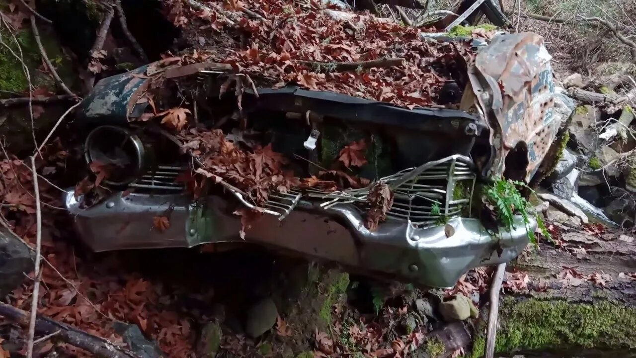
I followed the steep gully down closer to the creek. I did run across a faint user trail near the bottom that I followed to get back up. It's still steep as heck and there's some near Class-3 moves to get up. It's around 150 ft. vertical drop from the trail to the creek. You can see that in the condition of this car vs. the first one. But most importantly, I now know there's an exit from the canyon here, about the only one for half a mile in either direction.
Looking at my GPS tracks, I see that I was about 200 ft. down stream of where I stopped in Oct. There must be at least one more waterfall up stream, that may call for a return trip, stay tuned. I also need to figure out how to look at my old tracks and way points while recording a new track. I think I have an idea that I'll try out on a future trip.
There's a prominent band of Serpentinite rock in the middle of the slide area. It's a metamorphosed basalt, likely ancient seafloor material, that was subducted under the continental plate 50-100MYA at a depth of 30-50km. Since it's much less dense than the original basalt, it gets scraped off onto the continental plate and becomes part of the exotic terrane that forms much of the west coast of US. It eventually ends up on the surface. It's actually the state rock of CA. This Serpentinite rock gets pulverized by the fault movement. Add water and it flows like wet concrete. As suspected, that band of rock runs all the way down to the creek.
Just past the slide area are several wrecked cars down below the old road. One is near the top and another one seems to be farther down. This area was acquired by the MidPen Open Space District around 1978. I suspect the road was gated at that time, so it likely pre-dates that time. If anyone has any ideas on the make/model/year of this wrecked car, feel free to post that in the comment section below.
I think I'm finally getting a handle on how to get Open Camera working better on my phone to record videos out on the trail, especially in low light. Been working through many settings over the last year or so. The challenging part is the video on the screen while recording always looks great, but then when you put it on a big display, you can see the issues. I had been trying settings recommended on YT videos, but those seemed to make things worse. Finally went back to what seemed to work early on and go from there. Still have some things to try to get dialed in, but hopefully the video quality is improved.
Paper: ENVIRONMENTAL GEOLOGIC ANALYSIS OF THE MONTEBELLO RIDGE MOUNTAIN STUDY AREA:
https://openlibrary.org/works/OL6891657W/Environmental_geologic_analysis_of_the_Monte_Bello_Ridge_mountain_study_area_Santa_Clara_County_Cali#editions-list
Pg. 22 mentions a landslide possibly associated with the 1906 earthquake that may be the one visible today.
More to come...
Subscribe for more content like this
Comment, rate, share & click the bell icon
And as always, thanks for watching
-
 20:47
20:47
MTNTOUGH Fitness Lab
20 hours agoDELAYED: Kyrgyzstan Ibex Hunt | A MTNTOUGH Original
15K -
 59:50
59:50
Trumpet Daily
20 hours ago $4.76 earnedThe End of the Trans-Atlantic Alliance - Trumpet Daily LIVE | Feb. 17, 2025
14.6K19 -
 52:05
52:05
PMG
11 hours ago $1.18 earnedWhat Does Freedom Cost? Steven Solomon's On-the-Ground Documentary in Ukraine
8.39K -
 2:38:54
TimcastIRL
12 hours agoElon Secret Child Scandal ERUPTS, Ashley St. Clair Story Goes Viral w/Bethany Mandel | Timcast IRL
181K115 -
 2:04:52
Kim Iversen
14 hours agoElon's Pumping Out Babies Like They're Tesla Model 3's | EU Panics Over Peace Talks, Wants More War
168K160 -
 1:05:35
Man in America
17 hours agoFort Knox & Trump’s Secret Gold Move—The Financial Reset NO ONE Is Ready For?
119K133 -
 2:21:20
Robert Gouveia
14 hours agoTrump Goes to SCOTUS! Judge CAVES on DOGE? Fani Willis Not Happy!
127K33 -
 20:41
20:41
Stephen Gardner
14 hours ago🔥You Won't BELIEVE What JUST Happened To Don Trump Jr.!!
134K219 -
 58:00
58:00
The StoneZONE with Roger Stone
12 hours agoEuropean Leaders Resist Trump Peace Overtures To Their Own Demise | The StoneZONE w/ Roger Stone
95.8K12 -
 9:29
9:29
AlaskanBallistics
13 hours ago $12.11 earnedWyoming Suppressors and Rifles at Shot Show 2025
113K6