Premium Only Content

Looking for the 1948 Structures and Roads
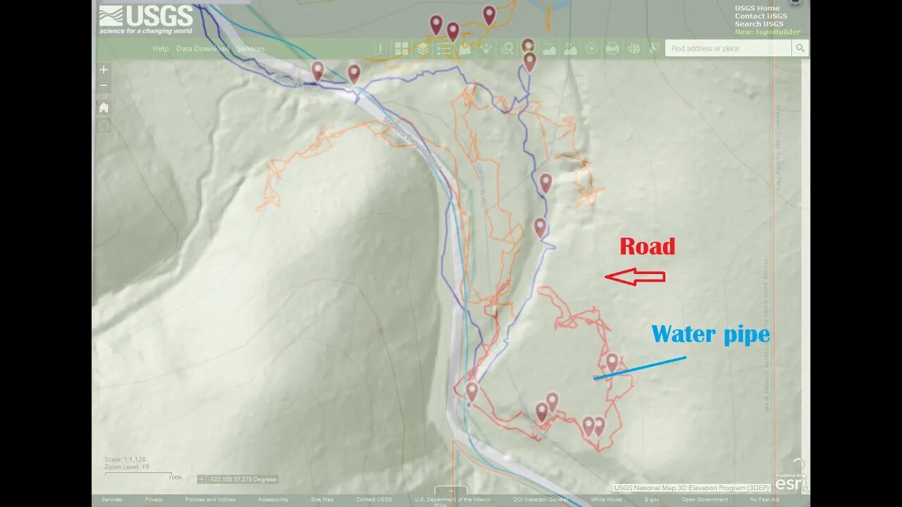
A return trip to see if the old road seen on the USGS HillShade map could be used to access the bench to the east of the creek where 2 structures are shown on the 1948 topo map.
It does give access to the bottom end of the bench but heavy brush prevented going any farther up towards the pond area. There were signs of past activity here, an old fence and water pipe along with an old road cut along the foot of the canyon slope. Nice confirmation of being able to identify potential roads on the hill shade map and then being able to go out and find that road in real life.
Pretty slow going up in this area. A bit over an hour to go 0.32mi. or 0.5km. I might try again later this year when the water level drops in the creek like last October. That way, it's easier to move up/down the creek bed and then try accessing the bench from other locations.
Thumbnail image was an overlay of screen captures of the hill shade map and the GaiaG track done in Gimp. Was difficult to get a similar zoom level and get the 2 images to line up well.
USGS National Map Viewer:
https://apps.nationalmap.gov/viewer/
View/download maps on the TopoView site:
https://ngmdb.usgs.gov/topoview/
Subscribe for more content like this
Comment, rate, share & click the bell icon
And as always, thanks for watching
#USGS #HillShade
-
 47:50
47:50
Candace Show Podcast
6 hours agoBREAKING: Judge Makes Statement Regarding Taylor Swift's Text Messages. | Candace Ep 155
113K113 -
 1:14:23
Josh Pate's College Football Show
3 hours ago $0.29 earnedCFB’s Most Hated Teams | FSU & Clemson Future | Big Ten Win Totals | Star Rankings Overrated?
14.5K -
 1:33:47
CatfishedOnline
5 hours agoGoing Live With Robert - Weekly Recap
27.8K -
 55:18
55:18
LFA TV
1 day agoEurope’s Sudden Turn Against America | TRUMPET DAILY 3.6.25 7PM
32.2K3 -
 4:21
4:21
Tundra Tactical
4 hours ago $2.12 earnedPam Bondi MUST Enforce Due Process NOW!
23.7K1 -
 56:42
56:42
VSiNLive
5 hours agoFollow the Money with Mitch Moss & Pauly Howard | Hour 1
48K1 -
 1:05:32
In The Litter Box w/ Jewels & Catturd
1 day agoShalom Hamas | In the Litter Box w/ Jewels & Catturd – Ep. 756 – 3/6/2025
103K37 -
 1:23:00
Sean Unpaved
7 hours ago $3.19 earnedNFL Free Agency
53.4K4 -
 18:25
18:25
Stephen Gardner
6 hours ago🔥The REAL REASON the Epstein Files are being HIDDEN | I CONFRONT Alan Dershowitz for details!
66.2K146 -
 1:58:44
The Quartering
10 hours agoTrump To Charge USAID Staff, Campus RIOT Erupts, Theo Von & Candace Owens, Ukraine Gets Worse!
117K72