Premium Only Content

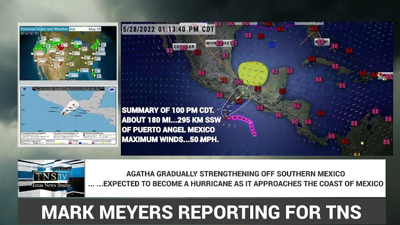
BREAKING: TROPICAL STORM AGATHA FORECAST TO BECOME A HURRICANE AND MOVE INTO S MEXICO BY LATE SUNDAY
FROM THE NATIONAL HURRICANE CENTER IN MIAMI
BULLETIN
Tropical Storm Agatha Intermediate Advisory Number 3A
NWS National Hurricane Center Miami FL EP012022
100 PM CDT Sat May 28 2022
...AGATHA GRADUALLY STRENGTHENING OFF SOUTHERN MEXICO...
...EXPECTED TO BECOME A HURRICANE AS IT APPROACHES THE
COAST...
SUMMARY OF 100 PM CDT...1800 UTC...INFORMATION
----------------------------------------------
LOCATION...13.5N 98.0W
ABOUT 180 MI...295 KM SSW OF PUERTO ANGEL MEXICO
MAXIMUM SUSTAINED WINDS...50 MPH...85 KM/H
PRESENT MOVEMENT...NNW OR 345 DEGREES AT 5 MPH...7 KM/H
MINIMUM CENTRAL PRESSURE...1000 MB...29.53 INCHES
WATCHES AND WARNINGS
--------------------
CHANGES WITH THIS ADVISORY:
None.
SUMMARY OF WATCHES AND WARNINGS IN EFFECT:
A Hurricane Watch is in effect for...
* The southern coast of Mexico from Salina Cruz to Punta Maldonado
A Hurricane Watch means that hurricane conditions are possible
within the watch area. A watch is typically issued 48 hours
before the anticipated first occurrence of tropical-storm-force
winds, conditions that make outside preparations difficult or
dangerous.
Interests elsewhere in southern Mexico should closely monitor the
progress of Agatha. Additional watches and warnings will likely be
required for portions of this area later today.
For storm information specific to your area, please monitor
products issued by your national meteorological service.
DISCUSSION AND OUTLOOK
----------------------
At 100 PM CDT (1800 UTC), the center of Tropical Storm Agatha was
located near latitude 13.5 North, longitude 98.0 West. Agatha is
moving toward the north-northwest near 5 mph (7 km/h). A turn toward
the northeast is forecast to occur late tonight or Sunday. On the
forecast track, the center of Agatha will approach the southern
coast of Mexico on Sunday and make landfall there on Monday.
Satellite data indicate that the maximum sustained winds have
increased to near 50 mph (85 km/h) with higher gusts. Additional
steady to rapid strengthening is forecast, and Agatha is expected
to become a hurricane on Sunday.
Tropical-storm-force winds extend outward up to 70 miles (110 km)
from the center.
The estimated minimum central pressure is 1000 mb (29.53 inches).
HAZARDS AFFECTING LAND
----------------------
WIND: Hurricane conditions are possible within the hurricane watch
area on Monday, with tropical storm conditions possible late
Sunday or early Monday.
STORM SURGE: Storm surge could produce coastal flooding near and to
the east of where the center passes the coast in areas of onshore
winds. The surge may be accompanied by large and destructive waves.
RAINFALL: Agatha will produce heavy rains over portions of southern
Mexico by Sunday into Tuesday night. The following rainfall amounts
are currently expected:
Mexican state of Oaxaca: 10 to 16 inches, with isolated maximum
amounts of 20 inches possible. Life-threatening flash flooding and
mudslides may occur.
Mexican state of Chiapas: 5 to 10 inches, with isolated maximum
amounts of 15 inches possible. Life-threatening flash flooding and
mudslides may occur.
Eastern portions of the Mexican state of Guerrero: 2 to 6 inches,
with isolated maximum amounts of 10 inches possible.
Life-threatening flash flooding and mudslides may occur.
Mexican states of Vera Cruz and Tabasco: 2 to 4 inches, with
isolated maximum amounts of 6 inches possible.
SURF: Swells generated by Agatha are expected to begin affecting
the coast of southern Mexico early Sunday. These swells are likely
to cause life-threatening surf and rip current conditions. Please
consult products from your local weather office.
NEXT ADVISORY
-------------
Next complete advisory at 400 PM CDT.
$$
Forecaster Cangialosi
-
 1:13:11
Flyover Conservatives
22 hours agoWARNING! Is Bitcoin CIA-Controlled? – The Shocking Reality of Digital Assets - Clay Clark | FOC Show
18.9K4 -
 2:00:37
Space Ice
9 hours agoSpace Ice & Redeye Try To Figure Out Seagal's Most Incoherent Movie
57K2 -
 1:00:36
PMG
23 hours ago $5.76 earned"Santa Trump is Giving Us Hope - But Will Johnson Stand Strong?"
59.1K9 -
 54:30
54:30
LFA TV
1 day agoThe German Strongman’s Arrival Is Imminent | Trumpet Daily 12.18.24 7PM EST
48.5K2 -
 2:04:11
Melonie Mac
7 hours agoGo Boom Live Ep 32! Soul Reaver Remastered!
40K8 -
 39:11
39:11
Sarah Westall
4 hours agoDigital Slavery and Playing with Fire: Money, Banking, and the Federal Reserve w/ Tom DiLorenzo
50.3K4 -
 1:38:38
2 MIKES LIVE
9 hours ago2 MIKES LIVE #157 ILLEGALS, PROTESTORS AND DRONES!
33.7K1 -
 1:01:03
LFA TV
1 day agoTHE LATEST SPENDING BILL IS AN ABOMINATION! | UNGOVERNED 12.18.24 5pm EST
36.9K36 -
 1:43:34
Redacted News
8 hours agoBREAKING! WARMONGERS PUSHING TRUMP TO LAUNCH PRE-EMPTIVE WAR WITH IRAN | Redacted News
146K261 -
 1:00:26
Candace Show Podcast
7 hours agoPiers Morgan x Candace Owens | Candace Ep 123
84K241