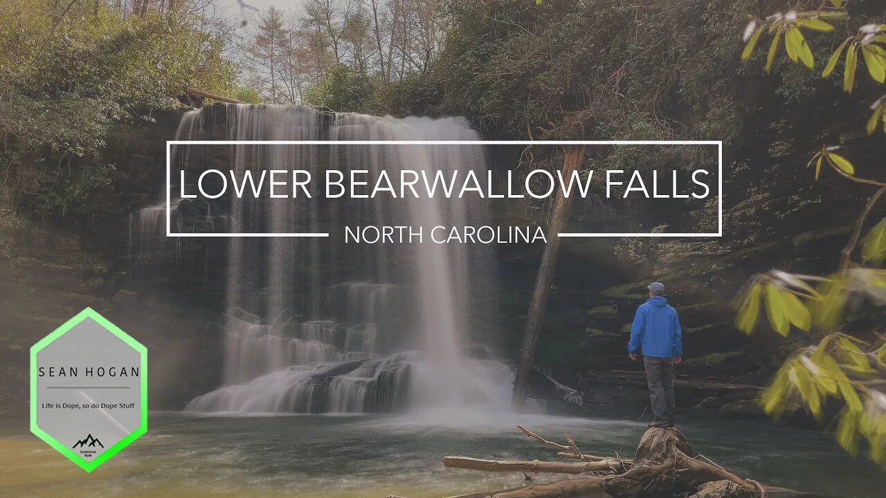
Lower Bearwallow Falls, NC -- 4K Cinematic
The Jocassee Gorges gates are open! My friends Lindsay, Amanda, Josh, Lesli and I took advantage, filled up the old Jeep & hit up Lower Bearwallow Falls. It is off of the Auger Hole Trail just over the border in North Carolina, pretty close to Gorges State Park in Nantahala National Forest. All the photos I’ve seen of these beautiful falls make it look much smaller than it is in person. These drone shots have a bit more perspective of their real size. 4WD with good ground clearance is a must on Chestnut Mountain Rd. Chestnut Mountain Rd itself is quite long, however, our destination was Lower Bearwallow Falls off of Auger Hole Trail. Auger Hole Trail took us through a creek crossing along an old Forest Road, then we turned off according to our directions on a ridgeline near Lower Bearwallow Falls. The descent down to the base of Lower Bearwallow Falls was rather steep and slippery. If visiting, this is NOT a beginner hike and you must be able-bodied and fit enough for the very drastic vertical in the final portion of the hike. The Green gates are typically open from Sept. 15 through Jan. 1 & March 15 through May 1. This is one of the WC 100 Challenge.
Instagram: https://www.instagram.com/nevergrowbored
My Photo Site: https://seanhogan.smugmug.com/
My Hiking Blog: https://nevergrowbored.blogspot.com
Twitter: https://twitter.com/seanhogan410
FB Page: https://www.facebook.com/seanhogan410
LinkTree: https://beacons.ai/nevergrowbored
Music Link: https://soundcloud.com/attommusicofficial/distant-memories
AllTrails Link: https://www.alltrails.com/explore/recording/lower-bearwallow-falls-7059b7d
Google Map Location of Parking Lot: https://goo.gl/maps/M16ybsbNpE3qSSqp8
Google Map Location of Falls: https://goo.gl/maps/LJ9xAh47CJRVZaBV6
GravelMap Offroad Map: https://gravelmap.com/route/53607-chestnut-mtn-auger-hole#13.63/35.0641/-82.94505
Electronic Equipment:
Trail App I use: https://www.alltrails.com
Drone I Use: https://store.dji.com/product/mavic-air-2
Handheld Gimbal I Use: https://www.dji.com/osmo-pocket
My Hiking Gear:
Boots: t.ly/qC2f
Daypack: t.ly/e3TH
Backpack: t.ly/CUTP
3P Tent: t.ly/bz4h
2P Tent: t.ly/jUhy
Hammock: t.ly/iIRz
Shorts (non-jorts): t.ly/dbFq
Socks: t.ly/MnOX
Shades: t.ly/LWSH
DJI Link to $10 Off Coupon: https://referral.dji.com/events/dji-referral/referrers/0f7ae30e-d8ad-492c-b24b-9e9004f9eb31/share
#blueridgemountains #hilliardfalls #jocasseegorges #waterfall #waterfalls #waterfallsnc #pisgahnationalforest #waterfallhike #northcarolina #lakejocassee
-
 4:51:08
Wahzdee
13 hours agoSniper Elite Then Extraction Games—No Rage Challenge! 🎮🔥 - Tuesday Solos
97.1K3 -
 2:12:58
Robert Gouveia
12 hours agoSenator's Wife EXPOSED! Special Counsel ATTACKS; AP News BLOWN OUT
104K41 -
 55:07
55:07
LFA TV
1 day agoDefending the Indefensible | TRUMPET DAILY 2.25.25 7PM
33.7K14 -
 6:09:26
Barry Cunningham
18 hours agoTRUMP DAILY BRIEFING - WATCH WHITE HOUSE PRESS CONFERENCE LIVE! EXECUTIVE ORDERS AND MORE!
86K50 -
 1:46:37
Game On!
13 hours ago $7.25 earnedPUMP THE BRAKES! Checking Today's Sports Betting Lines!
51.6K4 -
 1:27:21
Redacted News
13 hours agoBREAKING! SOMETHING BIG IS HAPPENING AT THE CIA AND FBI RIGHT NOW, AS KASH PATEL CLEANS HOUSE
198K284 -
 1:08:28
In The Litter Box w/ Jewels & Catturd
1 day agoCrenshaw Threatens Tucker | In the Litter Box w/ Jewels & Catturd – Ep. 749 – 2/25/2025
140K57 -
 44:57
44:57
Standpoint with Gabe Groisman
1 day agoWill Byron Donalds Run for Florida Governor? With Congressman Byron Donalds
60.8K10 -
 1:06:25
Savanah Hernandez
12 hours agoEXPOSED: FBI destroys evidence as NSA’s LGBTQ sex chats get leaked?!
94.3K38 -
 1:59:58
Revenge of the Cis
14 hours agoEpisode 1452: Hindsight
68.7K13