Premium Only Content

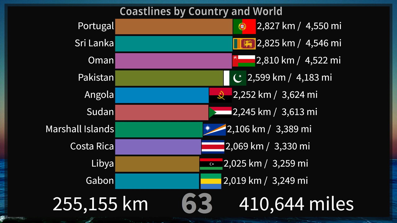
Length of Coastlines by Country and World
This bar chart show the approximated length of coastlines by country (top 100) and the world, in kilometers and miles, derived from World Vector Shoreline database at 1:250,000 scale.
The methodology used to estimate length is based on the following: 1) A country's coastline is made up of individual lines, and an individual line has two or more vertices and/or nodes. 2) The length between two vertices is calculated on the surface of a sphere. 3) The sum of the lengths of the pairs of vertices is aggregated for each individual line, and 4) the sum of the lengths of individual lines was aggregated for a country. In general, the coastline length of islands that are part of a country, but are not overseas territories, are included in the coastline estimate for that country (i.e., Canary Islands are included in Spain). Disputed areas are not included in country or regional totals.
Caspian Sea is included as part of coastlines, thus countries like Uzbekistan and Kazakhstan are not considered landlocked.
Macau and Hong Kong are included in China, but not Taiwan.
The world counter includes all coastlines.
Sources:
World Vector Shoreline, United States Defense Mapping Agency, Figures were calculated by L. Pruett and J. Cimino, unpublished data, Global Maritime Boundaries Database (GMBD), Veridian - MRJ Technology Solutions, (Fairfax, Virginia, January, 2000).
Music:
Rainswept - T.I.D.E.
https://soundcloud.com/rainsweptmusic/tide
T.I.D.E. By Rainswept is licensed under a Creative Commons License. https://creativecommons.org/licenses/by-sa/3.0/
Special Effect by:
AA VFX: https://www.youtube.com/c/dvdangor2011/
-
 1:05:00
Part Of The Problem
13 hours agoDave Smith | Trust the Science | Part Of The Problem 1196
59.9K36 -
 13:58
13:58
Tactical Advisor
18 hours agoBudget vs Expensive Shotgun
36K12 -
 14:19
14:19
justintech
14 hours ago $3.28 earnedBest Gaming PC Under $2000 - In 2024
21.3K6 -
 5:09
5:09
Guns & Gadgets 2nd Amendment News
23 hours agoFBI Stops 9/11 Style Terror Attack!!
36.6K24 -
 9:39
9:39
GBGunsRumble
1 day agoGBGuns Armory Ep 128 Kimber R7 Mako Carbon Compact
61.8K6 -
 1:00:51
The Tom Renz Show
22 hours ago"DEI Is Racist - Who knew & Redfield Now Worries About COVID Jabs"
74.3K9 -
 5:01
5:01
BIG NEM
14 hours agoInside the Albanian Mob... As a Serb.
39.4K2 -
 1:40:14
TheConnieBryanShow
4 days agoGAIN OF FUNCTION: MRNA, D.A.R.P.A. & THE PFIZER PAPERS
32K6 -
 2:14:01
Fresh and Fit
11 hours agoDr. Disrespect Moves To Rumble!
88.8K64 -
 6:14:53
Akademiks
14 hours agoDrake Sued his Label for Botting Kendrick Lamar Streams to 'End Him'. Kendrick Drops new video!
88.2K26