


Aether Round Table #41 Climate Change
Aether Round Table #41 Climate Change
Presented by toby:
https://discord.gg/EkuRVqvx
support the aethercos boys
Kofi
Aethercos https://ko-fi.com/aethercosmology
Alan https://t.co/rvMoGWEGEg
Shane https://t.co/51oNBhsogA
Cashapp
$Shanestpierre
$Alanspaceaudits
$tobyearth
548
views

Unveiling The Mysterious Powers Of Aether!
more mainstream Aether...
Unveiling The Mysterious Powers Of Aether!
https://www.youtube.com/watch?v=Rg-ugsB5Nao
“If you want to find the secrets of the universe, think in terms of energy, frequency and vibration.”
― Nikola Tesla
“Today’s scientists have substituted mathematics for experiments, and they wander off through equation after equation, and eventually build a structure which has no relation to reality. ”
― Nikola Tesla
827
views
1
comment
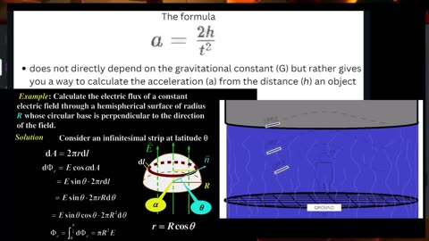
Flat Earther explains gravity in 2 minutes
Flat Earther explains gravity in 2 minutes
Little G expressed as a function of height and time on the fly inside the lions den 😅 ✊🙏💪
https://publish.obsidian.md/shanesql/Gravity
For those in the comments who will inevitably realize the above is simple kinematics and not dynamics, and will shout that I tried to trick them...
The Dynamic Causal mechanism explained:
https://x.com/AntiDisinfo86/status/1808888143640166415
836
views
2
comments
Just me wrecking globers
Shane Versus am Entire Discord Server full of Hardcore Globies on 'Gravity'
How do YOU think it went? 😆😅
Clipped from: "Shane Gets Wrecked At The MMM"
🤣
https://www.youtube.com/watch?v=CYHI4kW85_w
If you want to battle these guys, this is where they hang out:
https://discord.gg/eP3rf9wf
806
views

Just me wrecking globers
Just me wrecking globers
Compilation of Aether Boys wrecking globers just over last two days.
This video is a nicely edited transition from explaining little g, deriving little g on the spot, speculating about the causal mechanism of little g, destroying the traditional causal mechanism of little by reducing newtons law of gravitation to keplers 3rd law, right into maps, cosmography, and how geodetic surveying only ever proved a flat earth. Quite a day.
😅😂🤣
721
views
3
comments
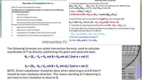
Geodetic Surveying, Spherical Excess, and Coordinate System Datums explained in 2 mins
Geodetic Surveying, Spherical Excess, and Coordinate System Datums explained in 2 mins
#ThanksMCToon @Mctoon27
Thanks mike 😅
Clipped from #FEF #Flatearthfriday
https://youtube.com/watch?v=KEECyFv1oT0
The TRANSCONTINENTAL TRIANGULATION and the AMERICAN ARC OF THE PARALLEL https://mctoon.net/wp-content/uploads/2020/02/transcontinental-triangulation-and-the-american-arc-of-the-parallel.pdf
Support the aethercos boys
Kofi
Aethercos https://ko-fi.com/aethercosmology
Alan https://ko-fi.com/space_audits#checkoutModal
Cashapp
$shanestpierre
$Alanspaceaudits
$tobyearth
#theodolite #surveying #AetherCosmology #Aether #Geocentric #theodolite #surveying #FlatEarth #AetherCosmology #Aether #Geocentric#🄻🄴🅅🄴🄻🄷🄴🄰🄳🅩 #FlatEarthFridays #FE #StationarySaturdaze #FlatEarthFriday #FlatEarthFridays #FlatEarthFriday #FlatEarth #flatearthfridaycrew
509
views

Do all Maps project the Globe? explained in 2 mins
Do all Maps project the Globe? explained in 2 mins
Clipped from #FEF #Flatearthfriday
https://youtube.com/watch?v=KEECyFv1oT0
The TRANSCONTINENTAL TRIANGULATION and the AMERICAN ARC OF THE PARALLEL https://mctoon.net/wp-content/uploads/2020/02/transcontinental-triangulation-and-the-american-arc-of-the-parallel.pdf
Support the aethercos boys
Kofi
Aethercos https://ko-fi.com/aethercosmology
Alan https://ko-fi.com/space_audits#checkoutModal
Cashapp
$shanestpierre
$Alanspaceaudits
$tobyearth
#theodolite #surveying #AetherCosmology #Aether #Geocentric #theodolite #surveying #FlatEarth #AetherCosmology #Aether #Geocentric#🄻🄴🅅🄴🄻🄷🄴🄰🄳🅩 #FlatEarthFridays #FE #StationarySaturdaze #FlatEarthFriday #FlatEarthFridays #FlatEarthFriday #FlatEarth #flatearthfridaycrew
583
views

#FlatEarthFridays Ep. 103 hosted by @100KryptoKeyz & @LevelHeadzHQ Rolling on X
#FlatEarthFridays Ep. 103 hosted by @100KryptoKeyz & @LevelHeadzHQ Rolling on X
@space_audits
#FlatEarth
Youtube:
Rumble:
Rokfin: https://rokfin.com/stream/50183
Bitchute: https://old.bitchute.com/video/ZtRpKyzTHet6/
x Broadcast:
Twitter: https://twitter.com/AntiDisinfo86
Odysee: https://odysee.com/asddd:e61a025c611a25aea8ce78457758b07ba630fa55
Also streaming on:
SpaceAudits: https://www.youtube.com/@space_audits
#FlatEarth
#theodolite
#surveying
#AetherCosmology
#Aether
#geostatisist
#geodatisist
#Geocentric
#theodolite
#surveying
#FlatEarth
#AetherCosmology
#Aether
#Geocentric
#🄻🄴🅅🄴🄻🄷🄴🄰🄳🅩
#FlatEarthFridays
#FE #StationarySaturdaze
#FlatEarthFriday
2.03K
views
1
comment

We have known for thousands of years the earth is a sphere! RIght?
We have known for thousands of years the earth is a sphere!
RIght?
....
Right guys?
Do you know HOW some guy 2000 years ago proved the shape of the earth?
https://publish.obsidian.md/shanesql/The+Circumference+of+WHAT%2C+though
Well...what actually happened was someone measured the CIRCUMFERENCE of our VISIBLE RADIUS. And told everyone with zero evidence that this applied to the physical globe earth that we stood on.... when it would be optically identical in either case.
This circumference is all that has EVER been measured, but the real question is,
THE CIRCUMFERENCE OF WHAT?
The physically curving ground that you have never seen and has never been measured by any human, ever. period.
OR....
The naturally curving celestial hemisphere?
Which, again, residents of both models agree is inherently curved, and both treat it as such.
It seems the circumference of the circle gets repeatedly measured, but how, in any of these instances, could you differentiate it being the circumference of a planar circle inside a sphere, or the circumference of the visible radius around you into the celestial heaven the same amount in every direction? [Which is also supported by Angular Resolution limit/aperture/wavelength of light/ diameter arguments for an optically curving planar earth]
one from the other from inside?? (See animation below)
What about that measured angle of the light would be different in a spherically curving earth, or an optically curving planar one?
Well there goes the whole basis for the globe !
"What!? You don't subscribe to the theory that 2000 years ago some dude assumed parallel light rays (against every observation) made a measurement of the angle of the sun, made a comparison to a known distance between two cities, then used the angle of the second observation to conclude THE WHOLE WORLD IS TILTED
D AT 23.4 Degrees? Since light beams from the sun that appear crepuscular are simply a trick that make it appear as if they aren't parallel.
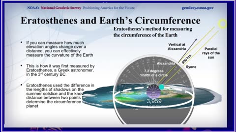
Eratosthenes, a Greek astronomer, and mathematician, measured the circumference of the Earth around the 3rd century BC. His method involved measuring the angle of the sun's rays at two different locations at the same time. Here's a step-by-step explanation:
Understanding the Setup:
Eratosthenes used two cities: Alexandria and Syene (modern-day Aswan), which are approximately 800 km apart.
He observed that at noon on the summer solstice in Syene, the sun was directly overhead (no shadow cast), while in Alexandria, it cast a shadow, indicating the sun was at an angle.
Measurement of the Angle:
In Alexandria, he measured the angle of the shadow, which was 7.2 degrees. This angle is the central angle corresponding to the arc of the Earth's surface between the two cities.
Calculating the Fraction of the Earth's Circumference:
The 7.2 degrees is 1/50th of a full circle (since 360 degrees / 7.2 degrees = 50).
This means the distance between Alexandria and Syene (800 km) represents 1/50th of the Earth's total circumference.
Quantifying the Circumference:
To find the total circumference (C) of the Earth, we use the formula: C=Distance×360∘AngleC = \text{Distance} \times \frac{360^\circ}{\text{Angle}}C=Distance×Angle360∘
Plugging in the values: C=800 km×360∘7.2∘C = 800 \text{ km} \times \frac{360^\circ}{7.2^\circ}C=800 km×7.2∘360∘
Simplifying the fraction: C=800 km×50=40,000 kmC = 800 \text{ km} \times 50 = 40,000 \text{ km}C=800 km×50=40,000 km
Summary
Eratosthenes' measurement was based on the following principles:
The difference in the sun's angle (7.2 degrees) between two locations.
The known distance between the two locations (800 km).
Using the proportion of the angle to the full circle (360 degrees) to determine the Earth's circumference.
His method provided an estimate for the Earth's circumference that was remarkably accurate for the time, giving a value of approximately 40,000 km.
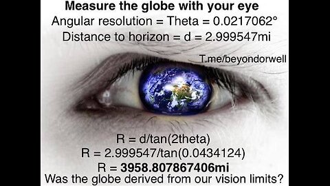
This of course applies to a circle as well as a sphere, especially defined by an that equation calculates the radius of a circle based on the angular resolution and the distance to the horizon.
R = d / tan(θ)
Where:
R = Radius of your spherical vision limit
d = Distance to Horizon
θ = Angular Resolution Limit
Eratosthenes used the cities of Syene (modern-day Aswan) and Alexandria in his famous calculation of Earth's circumference. Here are a few other city pairs and distances that could work similarly for measuring the Earth's circumference using a similar method:
City Pairs and Distances
Los Angeles and San Francisco, USA
Approximate Distance: 615 km (382 miles)
Both cities lie roughly on the same longitude.
Cairo, Egypt and Alexandria, Egypt
Approximate Distance: 180 km (112 miles)
Both cities are on a similar longitude and relatively close, making measurements easier.
Berlin, Germany and Hamburg, Germany
Approximate Distance: 290 km (180 miles)
Both cities are relatively close and on a similar longitude.
New York City, USA and Washington D.C., USA
Approximate Distance: 330 km (205 miles)
These cities are relatively close and roughly aligned north-south.
Beijing, China and Tianjin, China
Approximate Distance: 120 km (75 miles)
Both cities are on a similar longitude and relatively close.
Tokyo, Japan and Yokohama, Japan
Approximate Distance: 30 km (19 miles)
Both cities are very close and aligned north-south.
Madrid, Spain and Valencia, Spain
Approximate Distance: 350 km (217 miles)
These cities are relatively close and roughly aligned north-south.
Sydney, Australia and Newcastle, Australia
Approximate Distance: 160 km (99 miles)
Both cities are on a similar longitude and relatively close
Other stuff about the same:
Eratosthenes
https://www.youtube.com/watch?v=E-YBmX5a3qM&t=3702s
How do we know the Circumference of the limit of our vision?
https://www.youtube.com/watch?v=94xP53vbPQs&t=4s
DEBATISM X Ep X11: Roohif vs. Shane St. Pierre | Curvature: Optical or Physical?https://www.youtube.com/watch?v=VKgcMOhzNO4&t=3s
https://www.youtube.com/watch?v=2qz2yJWvvxc&t=49s Circumference of the Spherical Limit of your view
What did he measure? https://www.youtube.com/watch?v=9RShOAFh8JE
The Truth about Cryptosthenes, Eratosthenes, and the circumference... of what?
https://www.youtube.com/watch?v=DY72Op537nk
828
views
1
comment

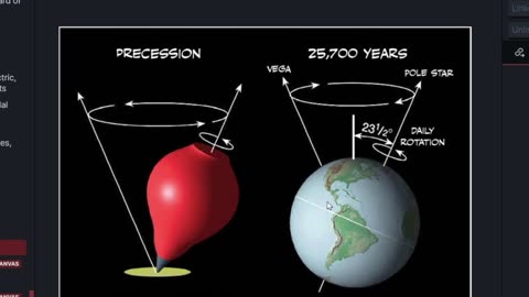
The Celestial Sphere + angles to Polaris on Flat Earth
The Celestial Sphere + angles to Polaris on Flat Earth
For all the Globers who are laughing at their own model without even knowing it..... https://publish.obsidian.md/shanesql/Library/The+Celestial+Sphere…
Rotating Sky Explorer https://astro.unl.edu/naap/motion2/animations/ce_hc.html
Shane's Flat Earth Dome Model
https://adl.place/shanes-fe-model
https://x.com/AntiDisinfo86/status/1775505383722832148
The Celestial Sphere
https://publish.obsidian.md/shanesql/The+Celestial+Sphere
69 Miles Per Degree mathed out properly
https://publish.obsidian.md/shanesql/69+Miles+Per+Degree
To any observer the night sky appears as if it is a hemisphere resting on the horizon. It is almost as if there is a surface to the heavens on which the stars seem to be fixed. This is why one way to describe star patterns and the motions of heavenly bodies is to present them on the surface of a sphere.
The celestial sphere presupposes that Earth is at the center of the view, which extends into infinity. Three-dimensional coordinates are used to mark the position of stars, planets, constellations, and other heavenly bodies. The Earth rotates eastward daily on its axis, and that rotation produces an apparent westward rotation of the starry sphere.
This causes the heavens to seem to rotate about a northern or southern celestial pole. These celestial poles are an infinite imaginary extension of Earth's poles. The plane of Earth's Equator, extended to infinity, marks the celestial equator. In addition to their apparent daily motion around the Earth, the Sun, Moon, and planets of the solar system have their own motion with respect to the sphere.
The Sun moves about Earth in an ecliptic plane. A line perpendicular to the ecliptic plane defines the ecliptic pole. All of the wandering stars in the sky appear to revolve around the Earth, so their movements are projected onto the celestial sphere nearly on the Earth's ecliptic.
At night the sky appears like a giant dome overhead, or an upside-down bowl set upon the horizon as if on a table.
The bowl of night is studded with the light of thousands of stars, of varying apparent magnitude.Some stars always retain the same spatial orientation with respect to each other; these are the fixed stars.
The fixed stars are distributed among 88 constellations (such as Ursa Major the Big Bear).
To the imagination, many star patterns other than the official constellations are discernible; these patterns are called asterisms (such as the Big Dipper and the Winter Hexagon).
The rim of the bowl of night is the horizon, or azimuth circle.
Azimuth = measured along the horizon, in degrees.By convention, azimuth is measured clockwise from due north.DirectionNorthEastSouthWest North-East-South-West = Never eat slimy worms.
Find north by using the Big Dipper to locate Polaris, the north star. Polaris is closer to true north than a magnetic compass.
Note: In Japan, azimuth is measured clockwise starting from the south.
The point directly overhead
733
views
1
comment

Aether Round Table #38 Meteors
Aether Round Table #38 Meteors
@space_audits
#FlatEarth
Youtube: https://youtube.com/live/xe3XNxu94k0?feature=share
Rumble: https://rumble.com/v54de8w-flatearthfridays-ep.-102-hosted-by-100kryptokeyz-and-levelheadzhq-rolling-o.html
Rokfin: https://rokfin.com/stream/50076
Bitchute:
x Broadcast:
Twitter: https://twitter.com/AntiDisinfo86
Odysee: https://odysee.com/dgghhd:62eb165ffb857e1d86975d730996b6d438909329
Also streaming on:
SpaceAudits: https://www.youtube.com/@space_audits
#FlatEarth
#theodolite
#surveying
#AetherCosmology
#Aether
#geostatisist
#geodatisist
#Geocentric
#theodolite
#surveying
#FlatEarth
#AetherCosmology
#Aether
#Geocentric
1.06K
views
3
comments
Are you lads down with the tri-wobble required by globularity?
Are you lads down with the tri-wobble required by globularity?
The tri-axes wobble of simultaneity?
Obviously, a little facetious there, but in all honesty, how does the uniform motion of a rotating sphere cause the effects needed by three independent axes of rotation?
**Cue the globers who will come tell me how stupid I am without refuting anything I have said 😂😅
709
views
1
comment


#FlatEarthFridays Ep. 102 hosted by @100KryptoKeyz & @LevelHeadzHQ Rolling on X
#FlatEarthFridays Ep. 102 hosted by @100KryptoKeyz & @LevelHeadzHQ Rolling on X
@space_audits
#FlatEarth
Youtube: https://youtube.com/live/ORRzrYuSLas?feature=share
Rumble: https://rumble.com/v545g8u-aether-cosmology-xspace-flatearth-on-thursday-night.html
Rokfin: https://rokfin.com/stream/50029
Bitchute:
x Broadcast:
Twitter: https://twitter.com/AntiDisinfo86
Odysee: https://odysee.com/ssads:42fc71bc12d3e0f3475ecd202665f6b168b32313
Also streaming on:
SpaceAudits: https://www.youtube.com/@space_audits
1.19K
views
1
comment
Aether Cosmology XSpace FlatEarth on Thursday Night
Aether Cosmology XSpace FlatEarth on Thursday Night
@space_audits
@tobyearth
#FlatEarth
Youtube:
Rumble:
Rokfin:
Bitchute:
x Broadcast:
Twitter: https://twitter.com/AntiDisinfo86
Odysee:
Also streaming on:
SpaceAudits: https://www.youtube.com/@space_audits
#🄻🄴🅅🄴🄻🄷🄴🄰🄳🅩
#FlatEarthFridays
#FE #StationarySaturdaze
#FlatEarthFriday
#FlatEarthFridays #FlatEarthFriday #FlatEarth
#flatearthfridaycrew
#FlatEarth
#theodolite
#surveying
#AetherCosmology
#Aether
#geostatisist
#geodatisist
#Geocentric
#theodolite
#surveying
#FlatEarth
#AetherCosmology
#Aether
#Geocentric
809
views
1
comment
Dispelling the vagaries when people stammer about Eratosthenes
Dispelling the vagaries when people stammer about Eratosthenes
Other stuff about the same:
Eratosthenes
https://www.youtube.com/watch?v=E-YBmX5a3qM&t=3702s
How do we know the Circumference of the limit of our vision?
https://www.youtube.com/watch?v=94xP53vbPQs&t=4s
DEBATISM X Ep X11: Roohif vs. Shane St. Pierre | Curvature: Optical or Physical?https://www.youtube.com/watch?v=VKgcMOhzNO4&t=3s
https://www.youtube.com/watch?v=2qz2yJWvvxc&t=49s Circumference of the Spherical Limit of your view
What did he measure? https://www.youtube.com/watch?v=9RShOAFh8JE
The Truth about Cryptosthenes, Eratosthenes, and the circumference... of what?
https://www.youtube.com/watch?v=DY72Op537nk
404
views
Æther Round Table
the Hildegard aether model part 2 [by Cassander]
Upcoming presentation by Dr. Robert Bennett re: the aether model presented in this book:
The True Conception of the World according to Hildegard von Bingen, Translated by Dean H. Kenyon
Link to book: https://aethercosmology.com/t/prep-for-bennetts-dww-prez/125?u=space_audits
The presentation will be focused on information starting on page 100.
If you have questions/comments, email them to alanspaceaudits@gmail.com with the title “BENNET PREZ” and we’ll make sure to get them answered during the presentation.
Thanks,
Aether Cos
934
views
1
comment
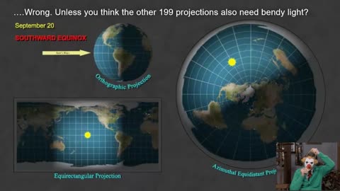
Light Distribution is equal on ANY map projection
Daylight Distribution is equal on ANY map projection, including the direction preserving azimuthal equidistant.
It is simply taken from observations all around the earth and most see it on the orthographic projection, so most people assume earth is a globe. THIS IS INCORRECT.
Song stolen from
@Inventionaire on twitter.
@ManOfStone on telegram
on here
https://www.bitchute.com/channel/9R5qSifG7j3j/
.
Go FOLLOW him.
378
views
Projected Coordinate System Datums are among the top reasons people think we live on a sphere.
Projected Coordinate System Datums are among the top reasons people think we live on a sphere.
_____
One more time, any calculations based on latitude and longitude will yield the graticule it was projected from.
To calculate those speeds, guess what they used?
ALL distances based on the graticule.
the formula for calculating the speed of a point moving along a circle's circumference, which is based on the circle's radius and the rotational speed:
𝑣=𝜔𝑟
where 𝜔 (omega) is the angular velocity, and 𝑟 is the radius of the circle at the latitude in question.
Angular Velocity (𝜔): Earth rotates 360 degrees per day, which translates to an angular velocity of 360∘24 hours=15∘ per hour.
Radius at Tropic of Cancer (𝑟):
The radius of the path of a point on the Tropic of Cancer can be calculated from the Earth's radius at the equator multiplied by the cosine of the latitude (𝑅cos(latitude)
Assuming Earth's average radius 𝑅 is about 6,371 kilometers, the radius at the Tropic of Cancer is 6371×cos(23.5∘).
With R≈6,371 km and latitude ≈23.5∘
the radius 𝑟 at the Tropic of Cancer becomes 6371×cos(23.5∘) kilometers.
Convert this radius into miles if required
(1 km = 0.621371 miles).
Use the radius to calculate the speed:
𝑣= 15∘ ℎ𝑜𝑢𝑟 × (𝑟 in miles or kilometers)
At the equator, the distance per degree of longitude is about 69 miles (or about 111 kilometers).
This is derived by dividing the Earth's equatorial circumference by 360 degrees.
The formula to calculate the actual distance per degree of longitude at a given latitude is:
𝐷=cos(latitude)×69 miles
ALL BASED ON THE GRATICULE.
ALL distances based on the graticule.
Now, consider the Sun.
Makes perfect sense, the sun is going the same speed in the south as it does in the north, but with a different tangential velocity . You know speed and tangential velocity are different, right?
V=wr VS V = d/t
Of course, since the Gleason map represents the exact same data as the globe, which is the same as every other map that uses the required longitude and latitude, the tropics are figured to be about 22,859 miles long. Because the math is based, of course, on the coordinate system....Its easy
Circumference of tropics l=2πR⋅cos(ϕ)
where
R [mean radius of the Earth, approximately 6378.137 kilometers]
ϕ is the latitude of the Tropic of Cancer in radians.
Or more accurately for your geoid.....
l=2πR⋅cos(ϕ)⋅(1−0.00669438sin2(ϕ))−0.5
(I mean, we are better globers than you as well)
Because YOU have to account for Earth's oblateness (flattening at the poles) using the eccentricity factor 0.006694380.00669438, and it subtracts 0.50.5 to adjust for possible overestimation.
Of course, you can always go backwards, and derive the latitude at your current tropic by
l = 2π cos(φ) ⋅ 6378137 ⋅ (1 - 0.00669438 sin^2(φ))^(-0.5)
Given l = 36788 km, we can plug this value into the formula and solve for φ.
36788 = 2π cos(φ) ⋅ 6378137 ⋅ (1 - 0.00669438 sin^2(φ))^(-0.5)
We have to denote φ = cos(φ) and φ = sin(φ), so our equation becomes:
36788 = 2φ ⋅ φ ⋅ 6378137 ⋅ (1 - 0.00669438 φ^2)^(-0.5
Right?
The Answers (FE Only)
---------------
1) What do all maps project?
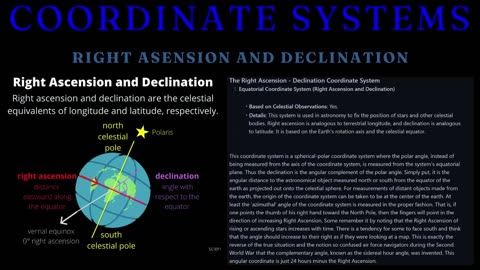
All maps project a coordinate system onto a flat surface. The most commonly used coordinate system is the geographic coordinate system, which models the Earth as a sphere or ellipsoid. This system uses latitude and longitude to specify locations on the Earth’s surface. Different map projections then transform these spherical coordinates into a two-dimensional representation, each with its own set of compromises regarding area, shape, distance, and direction.
2) How is latitude determined?
Latitude is determined by measuring the angle between the horizon and a known celestial object,
such as the Sun at its highest point (noon) or Polaris (the North Star) at night. This angle corresponds directly to the latitude of the observer. For example, if Polaris is 30 degrees above the horizon, the observer is at approximately 30 degrees North latitude.
3) How is longitude measured - what observations were crucial in establishing the farthest southern longitudes, as requested by the Board of Longitude in 1714?
Since The geographic coordinate system relies on the positions of celestial bodies to determine latitude and longitude, Taking angles to the stars at various longitudes was a fundamental aspect of properly mapping and refining the geographic coordinate system. They supposedly studied the variations of the night sky, as different stars become visible, and the lunar values - the angular distance between the Moon and a specific star - then compared them with distances listed in the nautical almanac.
4) What are the resultant differences in geodesic surveying, commonly referred to as 'deflection of the vertical', used for in regard to celestial navigation?
The deflections of the vertical are critical for accurate celestial navigation and are accounted for in various ways, including through the use of ephemerides and navigational almanacs.
They incorporate the deflections of the vertical to adjust the observed altitude. The deflections of the vertical are critical for precise celestial navigation. While they are not directly added to the almanac or ephemeris, correction tables or algorithms are used to adjust observed celestial altitudes. These corrections ensure accurate navigation by accounting for local gravitational anomalies, enhancing the reliability of positional data derived from celestial observations. Modern navigational systems and digital tools integrate these corrections
automatically, streamlining the process for navigators.
5) What are any of the 3 stated purposes of astrogeodetic surveying based on? [Based on the document "The Use and Abuse of Vertical Deflections,"]
Transformation of Astronomical Coordinates to Geodetic Coordinates: Converting coordinates determined by observing celestial bodies to those based on an ellipsoidal Earth model.
Conversion of Astronomic Azimuth to Geodetic Azimuth: Adjusting azimuths (directional angles) derived from astronomical observations to correspond with geodetic references.
Reduction of Vertical and Horizontal Angles to the Spheroid: Correcting measured angles to account for the curvature of the Earth, ensuring they align with the spheroidal model used in geodetic systems.
[Source for the paper]( https://www.semanticscholar.org/paper/THE-USE-AND-ABUSE-OF-VERTICAL-DEFLECTIONS-Featherstone/8e1900b750cd2687e2688972b9b4dc5c5773ac92)
Featherstone, W. E. (1999). The use and abuse of vertical deflections. In Proceedings of the Sixth South East Asian Surveyors’ Congress, Fremantle, Western Australia.
G Projector Map Software
https://publish.obsidian.md/shanesql/G+Projector+Map+Software
Cosmography
https://publish.obsidian.md/shanesql/Cosmography
Coordinate Conversions and Transformations including Formulas
https://www.iogp.org/wp-content/uploads/2019/09/373-07-02.pdf
Longitude
https://publish.obsidian.md/shanesql/Longitude
The Sky Mile Presentation
https://publish.obsidian.md/shanesql/The+Sky+Mile+Presentation
The Celestial Sphere
https://publish.obsidian.md/shanesql/The+Celestial+Sphere
69 Miles Per Degree
https://publish.obsidian.md/shanesql/69+Miles+Per+Degree
The Celestial Sphere
https://publish.obsidian.md/shanesql/The+Celestial+Sphere
Map Project
https://publish.obsidian.md/shanesql/Map+Project
Maps and the Coordinate Systems they are Projected From
https://publish.obsidian.md/shanesql/Maps+and+the+Coordinate+Systems+they+are+Projected+From
Sky Miles
https://publish.obsidian.md/shanesql/Sky+Miles
Maps and the Coordinate Systems they are Projected From
https://publish.obsidian.md/shanesql/Maps+and+the+Coordinate+Systems+they+are+Projected+From
Coordinate Systems
https://publish.obsidian.md/shanesql/Coordinate+Systems
Coordinate System and Map Projection Papers
https://publish.obsidian.md/shanesql/Coordinate+System+and+Map+Projection+Papers
Cartesian coordinates
https://mathinsight.org/cartesian_coordinates
Cylindrical coordinates
https://mathinsight.org/cylindrical_coordinates
Cylindrical and Spherical Coordinates
https://math.libretexts.org/Bookshelves/Calculus/Calculus_(OpenStax)/12%3A_Vectors_in_Space/12.07%3A_Cylindrical_and_Spherical_Coordinates
8.2: Spherical and Cylindrical Coordinates
https://math.libretexts.org/Bookshelves/Linear_Algebra/A_First_Course_in_Linear_Algebra_(Kuttler)/08%3A_Some_Curvilinear_Coordinate_Systems/8.02%3A_Spherical_and_Cylindrical_Coordinates
493
views

WE DO THIS FOR FUN!
WE DO THIS FOR FUN!
LOL What a great clip from Sacred!
https://x.com/100KryptoKeyz
#FEF on twitter 𝕏 spaces 🎙️🔥
I wanted to quickly show off the database, flex to the globers who say we never bring evidence (700+ papers in there), and reach out to the True Earthers.
If you have a question on a topic, I bet I have a tab on it already.
If not, let me know, and I will shortly create one =)
But this clip is off #FEF and @100KryptoKeyz talking to the anti flat earth groupies, and I think it totally works with me also displaying the mighty database lol
The link:
https://publish.obsidian.md/shanesql/Source+PDFs
Navigate to other tabs with the menu on the left
other links to my database
G Projector Map Software
https://publish.obsidian.md/shanesql/G+Projector+Map+Software
Cosmography
https://publish.obsidian.md/shanesql/Cosmography
Coordinate Conversions and Transformations including Formulas
https://www.iogp.org/wp-content/uploads/2019/09/373-07-02.pdf
Longitude
https://publish.obsidian.md/shanesql/Longitude
The Sky Mile Presentation
https://publish.obsidian.md/shanesql/The+Sky+Mile+Presentation
The Celestial Sphere
https://publish.obsidian.md/shanesql/The+Celestial+Sphere
69 Miles Per Degree
https://publish.obsidian.md/shanesql/69+Miles+Per+Degree
The Celestial Sphere
https://publish.obsidian.md/shanesql/The+Celestial+Sphere
Map Project
https://publish.obsidian.md/shanesql/Map+Project
Maps and the Coordinate Systems they are Projected From
https://publish.obsidian.md/shanesql/Maps+and+the+Coordinate+Systems+they+are+Projected+From
Sky Miles
https://publish.obsidian.md/shanesql/Sky+Miles
Maps and the Coordinate Systems they are Projected From
https://publish.obsidian.md/shanesql/Maps+and+the+Coordinate+Systems+they+are+Projected+From
Coordinate Systems
https://publish.obsidian.md/shanesql/Coordinate+Systems
Coordinate System and Map Projection Papers
https://publish.obsidian.md/shanesql/Coordinate+System+and+Map+Projection+Papers
559
views
1
comment

Rhumbline Networks, The Astrolabe, Zodiac Navigation, and the Aetheric Winds of Hildeguard
Rhumbline Networks, The Astrolabe, Zodiac Navigation by the 'houses of god', and the Aetheric Winds of Hildeguard
https://t.co/nJr1n0VWaF
588
views
Flat Earth Friday Ep 101 FLAT EARTH FRIDAY RETURNS
Flat Earth Friday Ep 101 FLAT EARTH FRIDAY RETURNS
Join the Space: https://x.com/i/spaces/1PlKQDbBBWyxE
tonight at (sometime probably)
@space_audits
@tobyearth
#FlatEarth
Streaming on
Youtube: https://youtube.com/live/RurOgCZWgJg?feature=share
Rumble: https://rumble.com/v52r513-aethercosmology-crew-flat-earth-on-thursday-night-3.html
Rokfin: https://rokfin.com/stream/49810
Bitchute: https://www.bitchute.com/video/tbkrW35UkcrA/
x Broadcast:
Twitter: https://twitter.com/AntiDisinfo86
Odysee: https://odysee.com/AethercosmologyCrewFlatEarthonThursdaNight:82cfedf1bfb1473e4877d25416be1c182ccf2fd4
Also streaming on:
SpaceAudits: https://www.youtube.com/watch?v=5TJXeNx69e4
#🄻🄴🅅🄴🄻🄷🄴🄰🄳🅩
#FlatEarthFridays
#FE #StationarySaturdaze
#FlatEarthFriday
#FlatEarthFridays #FlatEarthFriday #FlatEarth
#flatearthfridaycrew
#FlatEarth
#theodolite
#surveying
#AetherCosmology
#Aether
#geostatisist
#geodatisist
#Geocentric
#theodolite
#surveying
#FlatEarth
#AetherCosmology
#Aether
#Geocentric
1.42K
views
11
comments

Aethercosmology Crew Flat Earth on Thursday Night #3
Aethercosmology Crew Flat Earth on Thursday Night #3
Join the Space: https://x.com/i/spaces/1YpKkwwlBBoKj
tonight at 9pm est
@space_audits
@tobyearth
990
views